Sue and Martin in Mallorca 2019

Sue and Martin in Mallorca 2019
On the Archduke's Path in Mallorca

Saturday, 30 April 2011

Saturday 30 April 2011 - Puig Sant Martí and S'Albufera de Mallorca Natural Park

A short bus ride found Sue and me in Alcúdia by 10.40 on a cloudy morning with a cool breeze.

We soon warmed up by way of the rough and direct 266 metre ascent of Puig Sant Martí. A view from the summit is shown above. The hill was otherwise deserted, but judging by the amount of rubbish it does receive regular visits from the less environmentally conscious brand of visitor. Judging by the tacky streets in this part of Alcúdia, such visitors wouldn't have to stray far from their digs to reach this splendid little hill and its panoramic view.

The rest of the morning was spent negotiating our way without the benefit of a map to S'Albufera de Mallorca Natural Park, via a piece of waste ground with an abandoned chair that provided a suitable venue for lunch.

R+L were duly located after their 30 mile bike ride via Muro, and we spent a happy afternoon with Crested Coots and more Bee Orchids, to name just two of the plentiforous fauna and flora that will no doubt appear at some point by way of a link to a slide show.

That's all for now, as the demolition of a food and drink mountain is getting into swing, after which I'll be in no state to continue.

So it's goodbye from Mallorca for the time being...it has been an excellent trip.

Sent using BlackBerry® from Orange

Friday, 29 April 2011

Friday 29 April 2011 - The Mountain Road to Lluc Monastery


Pictured today at 10am, Robert, Lyn and me setting off from outside our apartment at the start of our journey on the road to Campanet.

Sue stayed at home to wallow in ... (most men would prefer to go to the pub, I suspect).

It was slightly cloudier today, but excellent conditions for cycling. It's a popular road for cyclists that leaves Puerto Pollença in the direction of Campanet. We by-passed that town in favour of some quiet lanes to Binibona, where morning coffee was not readily available.

However, a little further on in Calmari, we found a suitable café, which also for some reason was showing a 'royal wedding'. Robert was eventually dragged kicking and screaming from the TV, and our merry trio embarked on the gentle 400 metre climb up to Coll de sa Batalla. Robert went first and I thought I was behind him, but I got in with a group of seven road bikers from Surrey and didn't notice Robert coming back down the hill in search of Lyn.

So after a long wait at the coll, the easy descent to Lluc was most welcome. We lingered there for some time - lunch, botanical gardens, monastery, etc, before heading off along the scenic mountain road to Pollença via Coll de Femenia, at 640 metres probably the highest point I'll reach this trip. We kept stopping to snap the lovely views, so progress was agreeably gentle.

By and by, after a relaxing descent past Mortitxet, we cruised into Pollença, with Robert's bike seemingly on auto pilot. Straight to the ice cream kiosk. More tasty ices. They set us up for a final potter through the lanes back to the apartment for another thrilling episode with the barbecue.

Today's excellent route was about 64km and took a very leisurely less than seven hours.

Sent using BlackBerry® from Orange

Thursday, 28 April 2011

Thursday 28 April 2011 - Three Walks in One Day!

Sue and I don't possess any notable guide books or maps of Mallorca. Despite it being my third visit, I've always wondered whether I'd enjoy repeat visits, and my companions have always been heavily armed with literature. So my own library is unusually bare when it comes to Mallorca.

This time Robert and Lyn have everything you could want to know about cycling on the island, and Sue has borrowed the 'Walk Mallorca (North & Mountains)' Discovery Walking Guide, by Charles Davis. Thanks Nightbird. This week's walks have been based on some in that excellent guide book. We have no walking map.

Today Sue and I were kindly transported by R+L to Kilometre 12 on the scenic road to Cap Formentor on another beautiful warm, sunny morning.

This placed us in a fine location to tackle three of Charles's walks and be home by bus for 4.30.

Walk number 38 was our first target. Setting off at 10am, the easy stroll down to Cala Figuera, on a good track through the pines with tuneful chaffinches, hardly prepared us for what was to come.
The route from the beach up to the 299 metre summit of El Morro de Catalunya was rough and tough. Marked by cairns, it's easy enough to find the way, but very slow going. Not that one would want to hurry, given the fine views that unfold during the ascent through beds of Rosemary and St Johns Wort. Cap Formentor soon comes into sight, then from higher up there are views to the green fields of Casas Velles and, in the distance, the Torre de Albercutx. Today's picture was taken on the summit, looking west.

An hour later we had descended back down past chatty stonechats to the sparkling sea at Cala Figuera, where a few bathers were now installed on the rocky beach. It's a steep haul back up to the road, especially in this heat. We comforted ourselves in the knowledge that the heavily tattooed group of Brits in flipflops that we encountered may have found it tougher than we did.

That got us up to the car park at Kilometre 13 on the PM-221 road, the starting point for walk number 39.
Our 12.45 start took us down a pleasant lane towards Cala Murta. After 15 minutes, spot on 1pm, a picnic table appeared under a canopy of pine trees. Perfect timing for a picnic!

After lunch we headed along rough paths all the way up to Coll de Olivares. Near here the guide book describes having to climb a fence to enter privately owned land (ie trespass), but we were pleased to be able to negotiate the high fence by way of a sturdy new ladder stile. Mallorca has not always welcomed walkers, but I suspect the activity is now recognised as producing good income for the island, whose landowners are gradually becoming more tolerant. I suspect that thanks are due to in part to the numerous German visitors who love to walk on the island, for this gradual improvement.

Anyway, this potentially unwelcome barrier having been surmounted, we strolled on up the rough track to Coll de la Geneta, from where a trail of cairns led us directly over a rough limestone pavement to the spacious 332 metre summit of Na Blanca.

More fine views, especially towards this morning's summit.

On the cairned way up we had passed two Brits, the only two people seen out walking today. They had Charles Davis's guide book in their hands. Maybe the German guide books don't recommend today's routes?
Walk number 37 starts at Playa Formentor and covers the ascent of Na Blanca. Since we were already on that summit, all we had to do was follow walk 37 in reverse. This is pretty simple so long as you follow the basic rule about following cairned routes where there is no path as such. (If you lose the cairns retrace to the last cairn you found and start again.)

Not even a 'lost cairn' incident prevented us from achieving the descent to the bus stop in around an hour, though a 'low branch' incident did cause Sue to falter for a while, muttering "Why didn't you tell me about the low branch?" Simple - I didn't notice it!

A word of warning to potential passengers - the 15.45 bus back to Puerto Pollença left Formentor rather early!

We had been on our feet in the heat for nearly 6 hours, ascending around 700 metres in total, covering only about 13km despite 'ticking off' three walks in Charles's book.

R+L have now arrived back from a 47 mile peramble on their bikes, including a couple of hours in Manacor looking for lunch.

'Paella' is calling from our local restaurant...

Sent using BlackBerry® from Orange

Wednesday, 27 April 2011

Wednesday 27 April 2011 - A Ride to and a Trip to Pollença


A glorious sunny morning greeted us today. Robert, Lyn and I were quick off the mark, with a cycle ride to Cap de Formentor planned before the traffic got too heavy.

The plan worked, and we enjoyed a great four hour ride to the point and back. 44km with 860 metres ascent. Lovely views (Lyn and I are pictured at the Cap, where we also enjoyed coffee and cake).

Meanwhile, Sue got the bus to Pollença and climbed Puig de Maria before meeting us for tapas.

The rest of the day disappeared in a blaze of activity involving Pollença, a misplaced car, some fizzy wine and an adventurous barbecue.

Sent using BlackBerry® from Orange

Tuesday, 26 April 2011

Tuesday 26 April 2011 - A Stroll to Penya Roja

Woke to a cloudy day and a clumsy kitchen (still haven't cleared the broken bottle from behind the 'fridge!). Light rain fell as we breakfasted, wondering how those at home were coping with the UK's heatwave.

Good news has arrived on the grandparenting front - Kate and Jacob are back at home and the lad is getting on well with his new surroundings.

This morning Sue and I got a lift in Robert and Lyn's taxi, and after a few false trails in Alcúdia we were dropped off at the beach near Campamento de la Victoria. A 40 minute stroll up to Ermita de la Victoria was rewarded with a coffee at the otherwise deserted restaurant. But the narrow path to Penya Roja was really busy. It runs alongside cliffs to some fortifications that overlook Cap del Pinar. After squeezing through a small tunnel we clung on to a chain fastened to the rocks above a 250 metre plummet into the sea (one bounce or two?) for the unwary. Having survived thus far it was an easy scramble to a lonely cannon that has spent the last 400 years perched atop Penya Roja. It wasn't so lonely today though, with hundreds of German tourists clambering all over it.

After retracing our steps for a while, we returned to the track that narrows to a steep mountain path for the ascent to our highest point of the day, Talaia D'Alcúdia, an excellent spot for lunch amongst the asphodel - 445 metres, with fine views in all directions on this now clear day.

It's was a sunny hour from here to Coll Baix, down at 130 metres. The path crosses the bare slopes of the Puig d'es Boc before descending in zigzags. A vertiginous view (pictured) at the top of these zigzags affords one the pleasure of the sight of the churning waters on the beach at Platja de Coll Baix, which can apparently be a dangerous place to bathe.

From Coll Baix, pleasant woodland paths led us all the way back to Alcúdia, via an incident with a bus that had mislaid its 20 passengers (we had seen them) and a rare encounter with some Bee Orchids that were flourishing in an innocuous ditch at the gates to Parc de la Victoria.

The old town of Alcúdia was a fine place to finish this walk, after 23km of strolling with around 800 metres ascent, in around 7 hours including breaks. A pot of tea at one of many cafés went down very well before we tracked down a bus back to Puerto Pollença. Provisions had been laid out by R+L for us to construct a meal, which was duly wolfed down after that duo had returned at 8pm from a 55 mile bike ride.

So today turned out to be a lovely day, despite the early drizzle, but we have heard the sad news from SAHH that there has been a temporary hiatus in Timperley's April heatwave.

Sent using BlackBerry® from Orange

Monday, 25 April 2011

Monday 25 April 2011 - A Bike Ride to Muro

Firstly, thank you, everyone, for your messages, including an entire tome from Clive Dunn's department of literacy, concerning grandparenthood. Everything is going well and we'll be visiting the youth as soon as we return to the UK.

Today Sue set off early for a walk to Cala de Sant Vicenç, including a scrambly diversion to a summit.

Meanwhile the three cyclists headed off in a fairly random direction, past the Parc Natural de S'Albufera de Mallorca, towards the small town of Muro.

Avocets and egrets entertained us in the Parc, but there was no sign on this route of the rare crested coots that we saw here last year.

Muro was reached after Robert had got through another inner tube, and the café where R+L planned to enjoy lunch was eventually found after several tours of the environs of the church pictured above. It sits on top of a small hill that is visible from miles away. The desired café was less visible.

Excellent vegetable pasties and delicious cake were 'on tap' when we eventually found the place.

A few drops of rain reminded us of the overcast day, before we were further distracted, beyond the hilltop village of Búger, by another of Robert's punctures. This time the culprit was found - a small piece of glass in a tyre, persistently rubbing through a whole batch of inner tubes.

Even into a head wind, the journey past Campanet along a pleasant valley between two ranges of hills was most enjoyable. Our 65km ride was completed by 5pm, in plenty of time for a visit to Bruce's ever more crowded bike shop. We depleted his dwindling reserves of inner tubes and grabbed a big spanner to move my saddle into a less cramped position.

There were lots of bikers out today, many on hired bikes. Few will have enjoyed such a splendid evening meal as our quartet's home cooked fayre of pork tenderloin with cauliflower cheese and much more, followed by pears in red wine.

Sent using BlackBerry® from Orange

Sunday, 24 April 2011

Sunday 24 April 2011 - Overcast in Puerto Pollença

Yesterday disappeared in a surreal puff of time. Kate's early "I've just had a baby" call was of course the highlight, but in no time at all we had planted some onions in Barney and Carmen's massive garden, then 'Uncle Mike's' taxi zoomed us off to Terminal 1, and before we knew it we were toasting the new parents from a table at 'can Cuarassa'. It's an excellent restaurant just a few minutes walk down the road from the apartment here in Mallorca that we are sharing with Robert and Lyn for the week.

The weather here is temperate. We have moved from a UK heatwave to April showers in Mallorca.

After waving Sue off on a scenic walk in the Bóquer Valley, and a trip to the local bike shop to collect my hybrid bike for the week (R+L have already been here for a few days so have their bikes), the three of us set off on an undulating 45 km tour of the Alcudia peninsula.

A coffee at the Mirabel de la Victoria set us up for the afternoon's trip to Port d'Alcudia, where various more produce was scoffed and Lyn tried to resuscitate a dying horse (pictured). A planned 'long way round' route home was rejected after spots of rain appeared from ominous black clouds.

Luckily, we made it back before the rain started. Sue had returned, loaded with pictures of flowers, and we enjoyed an exciting evening in the apartment.

Sent using BlackBerry® from Orange

Saturday, 23 April 2011

Not a Spanish Training Camp

Whilst Poor Michael is being put through his paces in the mountains above Marbella, Sue has dragged me away to some other place - this photo taken from Robert and Lyn's taxi as we neared our destination.

Sent using BlackBerry® from Orange

Grandad

Jacob, one hour old, on 23/4/11
My daughter Kate excelled herself this morning by producing my first grandchild, Jacob, six pounds, at 6.15am.  Three and a half weeks early, but the poor lad was clearly feeling too hot and elected for an early bid for freedom.

Congratulations to Kate and Simon, and if Kate reads this (which I don’t think she will) I really don’t think you need to change his name to Gollum – I’m sure his looks will improve!

Friday, 22 April 2011

The Mobberley 8 – A Good Friday Tradition

“Fancy a bike ride tomorrow:
The first pub is the
Plough and Flail, a bit of a posh joint. It's good to get there for around 11.45am.
The order of battle is:
Plough & Flail > Stag at Warford > Frozen Mop > Bird in Hand > Bull's Head (popular lunch stop, bring butties) > Church > Chapel House > Railway.”

JJ is an expert at leading people astray.  Anyway, I couldn’t resist finding out what this was all about so I popped down to meet him at the Bird in Hand and the Bull’s Head.

It was very hot and summery.  “Sometimes it snows” someone observed.  Apparently this unstructured event started around thirty years ago.  The protagonists are still around, this year (perhaps always) cleverly disguised as chickens.  It’s not organised.  It just happens.  There’s music at the end in the Railway.

Well done, JJ, you do get up to some pranks!

The pictures speak for themselves, mostly.  But keen observers may notice a ninth pub, The Roebuck, in the background.  Apparently it has been banned from the event due to having perpetrated a misdemeanor regarding lunchtime food.

Outside the Bull's Head

This t-shirt contest has a clear winner…

This t-shirt contest has a clear winner

The whole thing was apparently started by a couple of chickens! Summer in Mobberley

Thursday, 21 April 2011

Thursday 21 April 2011 - A Lake District Backpack - Day 5 - Dalehead Tarn to Mary Mount Hotel

Poor Michael sets off from Maiden Moor towards Cat Bells, at a cracking pace...

It got hotter.  By 8am we were in shorts and t-shirts, on the summit of High Spy.

As indicated last night, I enjoyed a quick trip up Dale Head in the cool of the evening.  Even then it was pretty warm.  Coming down was Ethan, on his first solo backpack, having spent the day coming to Dalehead Tarn from Esk Hause.  Via Pillar!  A long day out, and quite a challenge.  Well done, Ethan.  We chatted later and it seemed clear to me that whatever else life throws into the path of this youngster, he has the great satisfaction of knowing that a lifetime love of hillwalking awaits him.  It can be very therapeutic at times, Ethan, and is always enjoyable – albeit sometimes in retrospect.

Continuing on to Maiden Moor, Cat Bells, and our final summit, Skelgill Bank, Derwent Water, looking glassy through the haze, gradually got closer, and we started to meet more and more people.

“It’s his first mountain” said one proud dad as his young son enthusiastically tackled the scrambly bits near the summit of Cat Bells.  I wonder how many people can name Cat Bells as the first mountain they climbed?  Quite a few, I suspect.

We made good progress in between stopping for chats with random folk, and trying to take photos of the haze that will need to be ruthlessly edited to avoid an excruciatingly boring slide show.  The final hour or so was spent strolling pleasantly around the edge of Derwent Water and back to Mary Mount Hotel for a drink and a sandwich before the hot drive home.  On the causeway before Mary Mount we bumped into Maggie and Roy, on a stroll around the lake from Maggie’s dad’s house in Keswick.  It’s a small world.  These two know Don and Liz, to whom we gave tea yesterday, and my children spent New Year in Maggie’s dad’s house when they were very small and Maggie’s parents owned the B&B at the other end of the garden.  Happy memories, including some NYD ‘strolls’ up Skiddaw.  Maggie has even attended one of these Lakes backpacking trips in the past, when we camped at Sprinkling Tarn, if my memory is correct.

Today’s 11 km stroll took a little over 4 hours, but included less than 400 metres of ascent, in deference to Poor Michael’s failing health.  That Spanish Training Camp should sort him out for the TGO Challenge, though!

Seriously, this was a great little outing in the finest scenery and company, not to mention the unexpectedly pleasant weather.  We learnt a lot from the experience, and will apply that in relation to kit, food and route, to our approach to the TGO Challenge, to which we are both really looking forward.

Wednesday, 20 April 2011

Wednesday 20 April 2011 - A Lake District Backpack - Day 4 - Blackbeck Tarn to Dalehead Tarn


Waking to a clear blue sky, with the sun on the tents by 7am, made for a most pleasurable start to the day. By the time we set off at 7.40, others who had been camped nearby were seemingly long gone.

A short stroll led to Innominate Tarn, Alfred Wainwright's final resting place, pictured above with Pillar in the background.

Moving on, we savoured fine views from the summit of Hay Stacks before enduring the steep descent to Scarth Gap. Here, my original plan was eschewed in deference to Poor Michael's allergic reaction to excessively steep hills. [He has been booked, at no expense spared, into a Spanish Training Camp, in the high altitudes above Marbella, in an effort to prepare him for the rigours of the TGO Challenge!] So we headed down from Scarth Gap to the sunny shores of Buttermere, chancing upon happy tourists, tufted ducks, and a myriad of near perfect reflections in the still waters along the way.

By now we were in shorts. It was hot. At the tea shop we sought out a table in the shade. At 10.30 on 20 April! "Not a bad day for July" quipped the owner, before launching into a whinge about the National Trust and its perceived lack of sensitivity to the local people and to other landowners.

I can recommend the chocolate cake.

A welcome breeze accompanied us for the ascent of Robinson, during which a long pause on the interestingly named minor summit of High Snockrigg afforded fine views towards Buttermere village and Crummock Water and Loweswater in the haze beyond.

No need for a fleece though, despite the breeze. Lunch was taken along with a smattering of families, backpackers and others on the broad summit of Robinson.

Setting off with some D of E gold students (the two boys were enjoying it, the two girls weren't), we left them at the saddle to traverse easily up Hindscarth, with excellent views to the Newlands valley and Keswick. Paragliders were again out in abundance. This must be their ideal weather.

It's a fine walk from Hindscarth round to the distinctive stone cairn that adorns the summit of Dale Head. Here, our four D of E students had been reunited with a chatty minder who was trying to coax them down to the tea shop at Honister. They were tired; they'd come from Buttermere.

Our own walk was now nearly over for the day, the 20 minute descent to Dalehead Tarn revealing some enticing green swards for the tents. But with the bedrock only an inch or so beneath the grass, we chose some pitches on the nearby rougher - but softer - grassland of the fell. Very comfy it is too.

It was only 3.50pm; we had walked about 13km, with 1100 metres of ascent, in just over 8 hours. Mr Sloman should be impressed, and with yesterday's performance of 17km in 11 hours, as I think this just about qualifies as 'Daunder Pace' - ie less than 1mph! Would you credit it?!!

The late afternoon passed very merrily as various passers by chatted at length, and one unexpected pair of reprobates called in at our hastily constructed (seating arrangements were still being debated) tea shop. It was great to see you - the tea certainly seemed to make you speed off up High Spy!

It's another beautiful evening up here at 500 metres, and our short day has given us plenty of chance to enjoy it.

PS Back up to Dale Head for a signal. Brilliant here at 8.30pm. Thanks for all your comments, I'll make appropriate responses tomorrow. I'm glad Alan seems to have resolved the boarder issue, I was wondering how to deal with that!

Poor Michael would say hello, but he's currently indisposed (ie sleeping off today's hills).

Goodnight.

Sent using BlackBerry® from Orange

A Chance Encounter at Dalehead Tarn


At Dalehead Tarn Tea Shop on a sunny Wednesday afternoon....

Sent using BlackBerry® from Orange

Tuesday 19 April 2011 - A Lake District Backpack - Day 3 - High House Tarn to Blackbeck Tarn, by Haystacks


A perfectly clear morning greeted us today, so we can't really complain about the slight haziness.

The early morning reflections in the tarns were wonderful. I thought I had a picture here, but it must have been taken with the camera, so you'll have to wait.

Today's picture is, instead, of our camp at Blackbeck Tarn, taken at sunset, when I discovered that the planned image didn't exist.

We started the day with a quick trip up Glaramara, before idling our way back over Allen Crags to the main path between Sprinkling Tarn and Angle Tarn. Here, a National Trust operative was dutifully collecting bits of wood from the hillside and burning them one by one to avoid setting the peat alight. "Our lunch hut was destroyed by a whirlwind" he offered.

Esk Hause revealed our first (of many) walkers of the day. There were a couple of folk on Great End when we arrived there, but Ill Crag was deserted for the duration of a leisurely brew stop in the sunshine.

T-shirts were the order of the day for us, but up on Scafell Pike many of the elated tourists were bare-chested. It was very busy in a congenial sort of way. Whilst waiting for Mike, who slowed on the final steep climb, I acted as resident photographer on the summit mound. Two neighbours spotted each other - "Well, if we'd known you were coming here we could all have come in one car!"

Mike and I had dutifully climbed Broad Crag on our way to Scafell Pike. It was deserted. As we got back to the main path a child asked his parents if he could scramble up the Crag. Despite the lad's reasoned plea - "Why do we come to these places if we can't do a bit of scrambling?" his request was dismissed out of hand. A 'debate' followed after I sided with the child - "You take him up then" concluded the parents. I should have done. A missed opportunity.

By the time we had nipped sackless up Lingmell, strolled down the Corridor Route via a pleasant lunch spot, and arrived at the Stretcher Box at Sty Head, it was after 3.30 and everyone else was going down. So the path up Great Gable was empty. At the summit I brewed up then waited for Mike whilst chatting to a couple of backpackers about GR20 on Corsica, and other trekking destinations. The girl's parents were in training for GR20, camping and unsupported, for her Dad's 60th birthday. Brilliant!

Mike eventually arrived, and with our final destination glowing far below in the late sun we bumbled on over Green Gable and Brandreth. Clouds had been building, but now they evaporated, though the thick haze remained. Very atmospheric.

After a pathless 2km, spent watching paragliders over Buttermere, we arrived at the main path between Haystacks and Honister Pass, and strolled finally onto a fine piece of turf by Blackbeck Tarn.

It's perfectly still here. There were even a few midges. After more good nosh, mine washed down with hot chocolate, I enjoyed a good wash with hot water before settling down to write this entry, which will be posted tomorrow as there's no signal here and I'm not inclined to go and look for one tonight.

Meanwhile, the peace of the camp site has been shattered by noisy geese and ducks, etc, but apart from the noise of the birds, I've also discovered why Anne doesn't mind Mike coming on these trips - it gives her a quiet night!

Today's 17km route, albeit with 1400 metres ascent, took us 11 hours. The pace was 'gentle'. That's rather longer than estimated, so as tomorrow's plan was a tougher day we have decided to miss out the Buttermere Fells, and head instead over Haystacks and down Scarth Gap to pick up our planned route at the Fish Inn.

Sent using BlackBerry® from Orange

Tuesday, 19 April 2011

Guess Where?


On a beautiful sunny day.

Sent using BlackBerry® from Orange

Monday 18 April 2011 - A Lake District Backpack - Day 2 - Below Great Crag to High House Tarn (NY 240 093 - 674 metres)


Yesterday concluded with an unforgettable visit to Great Crag in the light of the newly risen full moon and the red afterglow of sunset. It took some time for the posting to transmit, but on this lovely warm evening it was a pleasure to dally, trying to identify the wide array of Lakeland peaks that are visible from this splendid viewpoint. It's not the first time that an evening saunter in a quest for a phone signal has paid unexpected dividends. I tried to attract Mike's attention and go up again, but he was deep in slumber or i-pod.

Also reverting to yesterday, thanks in abundance must go to Nightbird and her esteemed worse half (whose normal nickname is inappropriate on this occasion) for the really excellent weekend that culminated in a lovely lunch that resulted in a minor food mountain for me almost immediately, as I felt no need for more food for the rest of the day.

Today dawned warm but cloudy, and that cloud dominated the day, with just a few sunny periods.

Good walking weather. Just as well! We managed 1500 metres ascent over our 20 km route. I'd planned to do it in 10 hours, but we 'overshot' by 45 minutes. Never mind, we arrived at this lovely sheltered spot with a view to Great Gable at 6.30, giving us plenty of R+R time. We need that - just reiterating the peaks we visited today is exhausting...

We started with Great Crag, my third visit in consecutive days - fine views. Then past Dock Tarn and a bit of a plod in t-shirts up to Low Saddle, High Saddle and Ullscarf.

The next summit, the distinctive feature of Lining Crag, was more a sort of ... well, crag than a summit. Here we brewed up and watched our first people of the day, pouring up the valley from Stonethwaite, many of them perhaps on the Coast to Coast route.

After the short ascent to Greenup Edge, our summiteering continued, monitored closely by wheatears, with Low White Stones and High Raise, the highest summit in the Langdale area. This heralded an array of 'Langdale' peaks - Codale Head, Sergeant Man, Thunacar Knott, Pavey Ark and Harrison Stickle, below which we enjoyed lunch and rather hazy views of the Langdale valley, with Windermere beyond, seemingly floating in the mist.

After a good break, we set off in search of Thorn Crag, which I'd missed on my last visit with Rick and Stuart & Co. This time I found it, but not without a struggle, eventually winding up at Bill Birkett's map reference via every other possible contending point for the name of Thorn Crag. It was ... a crag!

Loft Crag, however, is a nice summit. We visited that as well, before moving on to Pike O' Stickle, where we wisely dropped our sacks for the short, scary for Mike who hasn't visited the Langdales before, ascent to the airy summit.

A romp down to Stake Pass was then followed by the weary ascent of the ridge leading to Rossett Pike via Black Crag and Buck Pike, from where today's picture of the Langdale Valley was taken.

We managed then to avoid the temptation of the numerous camping spots near Angle Tarn, preferring to continue on up to Allen Crags and High House before plonking our tents in the gathering gloom in this sheltered spot near High House Tarn, where there's no running water. So we're filtering tarn water.

That's 20 Birketts and 11 Wainwrights for the day, by my reckoning.

After the usual sumptuous camp meals an early night was in order - by way of preparation for an easier day tomorrow!

It's spotting with rain and very overcast.

Sent using BlackBerry® from Orange

Sunday, 17 April 2011

Sunday 17 April 2011 - A Lake District Backpack - Day 1 - Mary Mount to below Great Crag


Have you ever found yourself driving home from the Lakes on a lovely Sunday evening, wishing that you could stay in the hills rather than prepare for all that Monday morning entails? I have, many times. But today that wish has come true. Mike and I are camped just below Great Crag at NY 270 150, on a wonderful evening.

Today's images show us setting off from Mary Mount on our 6 km stroll to camp (also shown) where we relaxed in luxuriant sunshine before losing it at around 8 pm.

My day started with a short stroll up Castle Crag with Sue, before returning to Mary Mount for the principal business of the weekend, Nightbird's birthday party. Thirty or so of her many friends attended this auspicious occasion, some of them visiting the Lake District for the first time. Yesterday's high cloud had dissolved into bright sunshine by lunch time, and was followed by a perfect summery afternoon. A red squirrel even visited the hotel's bird feeder.

'Poor Michael' duly arrived, and after a major boot faff on my part (I decided to use the trusty old Scarpa Infinities rather than the brand new HI-TEC Rainers that still need a bit of breaking in) we set off soon after 4 pm.

From Derwent House my navigation let me down (I blame Nightbird's wine) and we found ourselves amongst climbers and quite some way from our first target, King's How.

It was entertainingly thrutchy, especially after the huge lunch and with a 16 kilo load. So we missed our first planned summit - a good start?... But Brund Fell, a fine Birkett with extensive views made up for that, and soon afterwards, despite mislaying the path again, we arrived at this excellent spot, where I feel a very long sleep coming on.

Goodnight.

Sent using BlackBerry® from Orange

Saturday, 16 April 2011

Saturday 16 April 2011 - A Watendlath Round


Everyone else wanted an unstructured but easy day, probably involving Cat Bells, and I've been up there countless times, so I stuck to Plan A and enjoyed the 20 km round shown in the previous posting.

After a huge breakfast it was hard work up the thrutchy route by the Lodore Falls, but the path soon levels out and leaves the unfolding view of Derwent Water to meander through glades of wood sorrel, gently up to Watendlath (pictured).

A pot of tea went down well before I continued on this fine day up to Great Crag, a Wainwright I don't think I've visited before.

The Watendlath chaffinches, sparrows and robins were active as ever, almost taking food from your hand. A plump wood pigeon acted as an effective hoover.

Geese and pied wagtails were busying themselves as I passed on the way to Great Crag's twin summits, and a spot for tomorrow's wild camp revealed itself about 30 metres from the planned location.

It's a rough path to Dock Tarn, and rough, pathless ground from there to Blea Tarn, from the vicinity of which a short haul took me up to my second summit of the day, Watendlath Fell. Time for some lunch.

I'd met a few people, mainly couples enjoying quiet paths - this area is less frequented than Cat Bells, where others in our party encountered masses of folk.

There was hardly anyone else, though, on the broad ridge that I followed over the summits of Shivery Knott, Middle Crag, High Tove, High Seat, and Bleaberry Fell. There were good views ahead to Skiddaw and Blencathra, and all around to countless other Fells.

This route could on occasion be a bit boggy (the haul up to High Seat could perhaps be likened to that up Buckden Pike), but after recent dry weather it was fine today, with a little care. Wheatears and meadow pipits recorded my progress, and a buzzard made brief appearances all afternoon.

Beyond Bleaberry Fell a recently constructed 'yellow brick road' snakes down towards Walla Crag. More people were around now, but Walla Crag was otherwise deserted for a while as I sat there admiring the view across Derwent Water and Bassenthwaite Lake.

I gave up on trying to get an internet connection and headed down to Ashness Bridge before returning to Mary Mount along the shore path. Goldcrests were chirping merrily near Ashness Bridge, and dog violets and garlic mustard were in full bloom.

Today's walk was 20 km, with 950 metres ascent (though my new Garmin Gadget indicates more, having recorded my random meanderings rather than the straight line drawn on the map), taking 6.75 hours.

A fine day out (including 5 Wainwrights and 8 Birketts). The new boots rubbed a bit, but should be ok for tomorrow's backpack.

Better start packing! But first I'll enjoy the lovely evening from our bay window overlooking Derwent Water.

As for the others - some went around the lake, some went up Cat Bells, and some went up Castle Crag for an encore.

Sent using BlackBerry® from Orange

Friday, 15 April 2011

On the Road Again – Let the Fun Commence

The view from Great Gable towards Lingmell - 2 March 2011

I’ve just glanced at the calendar.  Out of the next 64 days, I’ll be at home for 12 of them, and after that it’s 50/50 for three months.  So after lots of ‘day trips’, the tent – last used in September on the Peebles to Moffat trip, has been dusted off and chucked into the Go-Lite Quest rucksack.

Whilst the Peebles to Moffat squad regroups for its totter back to Peebles, I’ll be enjoying a couple of nights of luxury at Mary Mount (J’s birthday celebration).  It’ll be ‘mobile blogging’ for a while, so I’m adding a few maps now, so that you can follow our progress, or even join us on the backpack.

Here’s a possible route for tomorrow (Saturday):

A walk from Mary Mount - 20 km, 950 metres ascent

20 km, with 950 metres ascent, and just the second time I’ll have worn the HI-TEC Rainer boots that HI-TEC sent to me after their trail shoes wore out.  They are determined not to give up on their efforts to get me to review something that I can conclude is ‘durable’.  We’ll see! 

That day walk will be covered by the first mobile posting.

Then Sue will head off home and I’ll be joined by ‘Poor Michael’ my companion on this year’s TGO Challenge (he now even signs his emails ‘Poor Mike’!) for five days in the wilds of the Lake District.

Here’s our plan for Day 1 (Sunday), starting from Mary Mount around 4 pm.  If we can’t find anywhere to camp at point 5, we may stumble on to Blea Tarn, but you may observe from the previous day’s route that I have ‘a cunning plan’.

We’ll be carrying a good 16 kilos (each!) at this point, so speed won’t be great.

Lakes Backpack - Day 1 - Sunday 17 April 2011 - 6 km, 500 metres ascent

Day 2 is a tough one and will test us, and our gear.  I’m hoping the new boots will be ok, but trainers have been packed just in case, rather than the normal Crocs.  We’ll be doing 21 km with 1500 metres of ascent.  Feel free to join us!

Lakes Backpack - Day 2 - Monday 18 April 2011 - 21 km, 1500 metres ascent

Day 3 (Tuesday) sees us going there and back to Glaramara before striking camp and heading to the top of England, before descending the Corridor Route and thrutching up Great Gable, from where we would like to enjoy views like the header picture taken last month.

It’s just 18 km, with 1400 metres ascent, culminating near Blackbeck Tarn, an excellent place for a wild camp.

Lakes Backpack - Day 3 - Tuesday 19 April 2011 - 18 km, 1400 metres ascent

Day 4 has the bonus of lunch in the fleshpots of Buttermere, before the long ascent of Robinson.  But by now we should have eaten our way through around 3 kilos of food, and used up most of our gas and consumables, so with only around 12 kg on our backs we should be romping up the hills.  If we are not shattered from the previous two days!

It’s 17 km with 1700 metres of ascent, with what I hope will be a good ‘pitch’, at Dale Head Tarn.

Lakes Backpack - Day 4 - Wednesday 20 April 2011 - 17 km, 1700 metres ascent

Thursday sees us returning to Mary Mount by lunch time – probably too smelly to venture inside! – via a pleasing romp over Cat Bells and alongside Derwent Water.  11 km with 400 metres ascent.
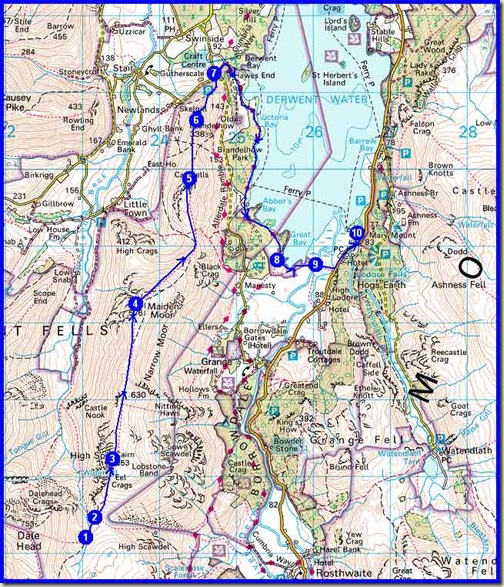
Lakes Backpack - Day 5 - Thursday 21 April 2011 - 11 km, 400 metres ascent

Do feel free to join us if you can – my phone will be on, and there is intermittent reception over most of this route.  It should be a great way to start the backpacking season for those of us who tend to take a ‘winter break’.  As you can see, short cuts are possible on each day – we hope to do the planned route, but we’ll see how it goes.

The trip after that will be rather a contrast, and will feature bicycles.

On a completely different subject, Gillian Price (author of guide books for walking in Italy) was in touch yesterday, delighted that the swifts have arrived in Venice (ours will be at least another month) and happy to tell us about a new Cicerone Guide - Trekking in the Alps.

She asserts - the authors are ‘all terribly proud of it and hope it inspires lots of people to go trekking’.

If you fancy going a little further afield, the 20 routes described in this book are all mouth-watering in their own way.  A number of them are hutting trips and can be done with just a small day sack, whereas others cover more remote areas where there are still mountain huts but wild camping may be possible.

Inspirational?  Quite possibly.  It’ll probably soon be added to our library.

Have a great weekend, everyone, and good luck to those on the Moffat to Peebles extravaganza.

Thursday, 14 April 2011

Baked Lemon Pudding

Baked lemon pudding - logo!

One of the simplest and most appreciated items on our recent Eskdale menu was Baked Lemon Pudding, a recipe taken from my first cookbook, 'Katie Stewart Cooks' (1971).

It’s quick and easy and often enjoyed by our family as part of Sunday dinner.  Delicious.

Baked Lemon Pudding

Ingredients

4 ounces (113g) self-raising flour
pinch of salt
4 ounces (113g) butter
4 ounces (113g) castor sugar
2 eggs, lightly beaten
zest of 1 lemon, finely grated
1-2 tablespoons milk to mix
castor or icing sugar for decoration

FOR THE SAUCE

4 ounces (113g) castor sugar
2 level tablespoons cornflour
juice of one lemon, made up to ½ pint (275ml) with hot water

METHOD

1. Sift together the flour and salt and set aside.

2. Cream together the butter and sugar until light and creamy, then gradually beat in the lightly beaten eggs and grated lemon zest.

3. Add a little of the sifted flour along with the last few additions of egg, then fold in the remaining flour and enough milk to mix to a medium soft consistency.

4. Spoon into a buttered 2-2½ pint baking dish and spread evenly over the base of the dish. Set aside while preparing the sauce.

5. In a mixing basin, combine together the sugar and cornflour, then stir in the mixed lemon juice and hot water.

6. Blend well and pour over the pudding.

7. Place immediately just above the centre of a fairly hot oven (190C/375F/Gas No 5) and bake for 40 minutes.

While baking, the cake mixture will rise to the top and the sauce will go underneath.

When baked, sprinkle with castor or icing sugar and serve the pudding with its own delicious lemon sauce. Other additives, such as double cream, crème fraiche, etc, are permitted.

This recipe is suitable for 4 portions.

It’s sadly not very photogenic, but I’ll try to add an image in due course.