Sue and Martin in Mallorca 2019

Sue and Martin in Mallorca 2019
On the Archduke's Path in Mallorca

Friday, 20 January 2012

Joe’s Cup

Joe's Cup 

The old enemy (time) has delayed the write up of my continuing perambulation along the Lancashire Trail with East Lancs LDWA group.  I’ll write about that next week, but here’s a highlight from Wednesday’s ‘plod’.

On the moor above the quintessential English village of White Coppice, stands the ruin of Drinkwaters Farm.  Norman claims to have known the old farmer – he probably hastened the poor man to an early grave!  The farm was so named because of a nearby spring which still flows, rather gently, just below the path from the summit of Great Hill.

Not far from the farm ruins is a small, discrete memorial to a local fell runner, Joe Whitter (1939-1991).

Joe, a member of Wigan Phoenix,  was one of Lancashire’s true fell running characters well known for his ultra-distance runs over these moors. The spring at Drinkwaters was used regularly by Joe and his companions on Sunday morning runs.  The February 1992 Fellrunner magazine contained an obituary where it was observed

“Joe Whitter was one of those essential characters that make fell running what it is. The Anglezarke Moors will be a poorer place without him and he will be sadly missed. Typically, Joe requested his ashes be scattered on the moors he loved, and there are many fell runners who will now be unable to run past Drinkwaters on Great Hill without remembering him.”

Norman seems now to have taken over custodial duties in relation to the cup, which is now used to collect small donations – here Anne is doing just that, making a donation.  With my money!  I’m sure it’ll go to a good cause.

Much of the text for this posting was taken from Ian Charters’ excellent running blog – here – I do hope Ian doesn’t mind.

I’m heading north for the weekend in a few minutes, so will be back next week with a fuller report on Wednesday’s walk from Rivington to Abbey Village.

Have a great weekend, everyone.

Back to Lancashire Trail Index

Thursday, 19 January 2012

Five Days of Winter Sunshine

Witchhazel at Dunham Massey Winter Garden - 15/1/12

The wet weather had to end sometime, and the forecast of fine weather was reliable enough to allow Rick, Stuart, JJ and me to enjoy a superb day in the Lake District on Friday.

The good weather continued until Wednesday morning, when we woke to fine drizzle from a low cloud.  I’m slightly ashamed not to have taken better advantage of the fineness, but the Parkrun on Saturday was under clear skies, and JJ joined Sue and me for a very pleasant 10km stroll to Dunham Park and on to Altrincham on Sunday.  The header image is from Dunham’s Winter Garden, and there’s a slideshow from that walk/visit here.

Monday saw me take advantage of the continuing fine, frosty conditions via a bike ride to Lymm and back, but the small camera (Canon Ixus 105) that I thought had dried out after its drowning last week decided to remain poorly, so no images of a lovely sunrise.  All was well until the sun caught the frozen mud of the towpath.  The surface couple of millimetres soon thawed sufficiently to be dragged up by each turn of the wheels.  It was like cycling through glue.  Glue that was thrown up and gradually enveloped both cycle and rider!  So whilst the conditions looked perfect for a ride, they were actually the opposite.  To cap it, our outdoor hose was frozen, so cleaning was laboriously attempted (‘achieved’ is not the correct word) using buckets of warm water to swill the mud…

Tuesday was another nice day, that somehow disappeared in a fog of forgotten activity.

And so to Wednesday, and fine drizzle from a low cloud – more of that later…

Tuesday, 17 January 2012

Friday 13 January 2012 – An Ullscarf Round

The steep ascent to Brown Rigg

My plan to pop up Moel Siabod, on this the first day of really good weather of the year, were soon adjusted when I realised I could enjoy a lift with JJ and Rick, whose target was a very pleasant round from Thirlmere, involving Ullscarf and six other minor summits.

After abandoning Rick’s car at a leisure centre between Carnforth and Milnthorpe, we were all transported by Stuart up to Thirlmere, where we drove around for some while looking for free parking.  We gave up, but £7 for a day’s parking does seem a bit steep.

Anyway, we ‘booted up’ and set off along the lane to Dobgill, where readers may prefer to park should they follow in our steps (same price, but the short road walk is avoided).

It was a lovely day, and we soon warmed up as we headed steeply up (pictured above) beside a wood in which trees were crashing down in the wake of a Forestry Commission chain saw.

Pausing for breath by a small ring of iron railings that may reveal the site of an old well, with Bella, Stuart’s young collie, the dog posed obediently, fooling Stuart into thinking she would be well behaved today.

Above the high point of the forest the gradient eased as we made our way towards the balanced rock that marked our first summit of the day - Brown Rigg (463m).

Navigation was no problem at all on this bright, sunny day, despite the pathless nature of most of our walk.  But it was easy going throughout, and we dropped gently down to Stone Hause before ascending an obvious ramp up to our second summit, Blea Tarn Fell (558m), with fine views towards Skiddaw.

Heading into the sun towards Standing Crag, the following image portrays the terrain and skyscape that was typical of this lovely winter’s day.

Descending in the sun from Blea Tarn Fell towards Standing Crag

After skirting around to the left, Standing Crag (611m) was easily attained.  Here’s JJ on the summit, with Bassenthwaite Lake and Skiddaw in the background.

JJ on Standing Crag, 611 metres

We contoured high above Blea Tarn, gradually rising towards a raven sentry on the Low Saddle of Coldbarrow Fell (656m), where superb views drew the eye north to Watendlath, Derwent Water and Bassenthwaite Lake.

The view to Watendlath, Derwent Water and Bassenthwaite Lake

Time for a Team Photo: Martin, Stuart, Bella, Rick, JJ:

Team photo at lunchtime on Low Saddle of Coldbarrow Fell (656 metres)

Lunch was taken, by four of us, anyway, whilst Bella disobediently foraged for victims on the fellside and finished up with JJ’s tasty scones. 

On the road again, we were soon looking back to High Saddle of Coldbarrow Fell (675m), from the ascent of Ullscarf (726m).

Ullscarf summit, our only ‘Wainwright’ of the day, afforded fine views of much of the Lake District, with Great Gable prominent to the west, and nearby Fairfield to the east.

To the south, we looked down to Helm Crag, with Windermere in the distance; Skiddaw and Blencathra vied for attention to the north.

From Ullscarf a pleasant descent over rough ground led to Wythburn Fell, with Seat Sandal and Fairfield directly ahead of us.

Descending from Ullscarf to Wythburn Fell, with Fairfield dead ahead

Here’s the approach to our seventh and final summit of the day, Wythburn Fell (508m), with the slopes of Helvellyn in the background.

Approaching the summit of Wythburn Fell (508m)

Our descent route on this short round continued north east along the broad rough ridge of Wythburn Fell, skirting a beacon and eventually picking up a path leading from Ullscarf Gill.  A right angle turn then took us gently back down to the car park at Wythburn.

From where a short drive led to this excellent rehydration point, starring ‘Collie Wobbles’, which is what Bella may also have had after stern words from Stuart.

The Watermill at Ings - for essential supplies

Here’s our route - approx 13km, 600m ascent, taking a leisurely 5 hours:

An Ullscarf Round - approx 13km, 600m ascent, 5 hours

Our 7 summits are marked above as points 2 to 8.

There’s a 37 shot slideshow here.

All in all an excellent first mountain day of the year.

Thursday, 12 January 2012

Wednesday 11 January 2012 - Marple Mellor Night Ride with the Manchester Mountain Bikers

Walc 'leads' a 'night ride'

Last night I enjoyed my second trip out with the Manchester Mountain Bikers, this time on a ‘night ride’, my main reason for getting together with this club.

A ride that lasts from 6.30 to 8.30 pm would more correctly be described as an ‘evening ride’, but it was dark, so who cares.  It was also fine, after another ‘mizzly’ day, and thankfully (whilst Liverpool were thrashing City in the rain in central Manchester) all we got by way of precipitation on this ride was a little very light drizzle.

Roman Lakes being closed, we started from Arkwright Road in Marple, taking care not to damage a pristine hedge, and soon after 6.30 I headed off with Walc, today’s leader, pictured above, Keith who I’d met before, and Steve, Adam, Richard, Austin and Poley, down the rutted lane towards Roman Lakes, then up the steep, rough lane to emerge at the golf course in Mellor.

This was the steepest part of the outing, which although ridable in its entirety somehow did seem to be mainly uphill.  Luckily Keith was ‘sweeping’ on this ascent, and arrived at the top carrying my rear mudguard and a foot protector that I’d lost without noticing.  Thanks Keith.  The other foot protector came off (my trail shoes turn out to be two bulky for these protectors, normally worn with trainers) and the mudguard was re-attached, though I spent the rest of the evening nervous about losing it again.

We were soon off again along the pleasant single-track to Brook Bottom and (sadly) past the Fox Inn.  Around here we lost Poley, allegedly due to a light failure, but I think he just fancied a drink. We then turned left to complete an interesting circuit via a fudge brownie break and Mellor Moor, with fine views of the lights of the surrounding towns, before regaining the single-track leading back down to the Fox Inn, which again we ignored, this time in favour of a steep but enjoyable descent to Strines Station on another track that hadn’t previously seen the wheels of one of my bikes.

Then it was easily back to the start via the lower track past Roman Lakes, chatting with Keith about bike trips to the Alps and Pyrenees.

I think Walc had intended to ascend back up to go around the golf course and down to Roman Lakes by a more sporting route, but it seems that he missed the turn.  I was quite happy with the short figure of eight circuit.

My new lights worked very well, and there was hardly any speed sacrifice due to the darkness, but a minor gear problem meant that I stayed in a low gear throughout the ride in a bid not to get covered in oil, so I tended to bring up the rear, being naturally the slowest on steep ascents and descents as well.  Sorry, folks, if I kept you waiting.

Here’s the approximate route – about 14 km, with 350 metres ascent, taking just over 2 hours.

Our 14km route included about 350 metres ascent and took about 2 hours

My Garmin Gadget produced the following data:

As noted above, we returned extremely muddy.  So when I got home I dumped my track suit straight into a sink to wash off the worst of the mud.  Oops, my camera was still in the pocket.  It drowned.  It will now sit in a bowl of rice for a few days in a (probably futile) bid to resuscitate it.  The memory card was undamaged, though, and at least it wasn’t my new camera…

All in all a very pleasant little excursion, despite the camera mishap.

Monday, 9 January 2012

Sunday 8 January 2012 – A Circuit from Taddington and some Strange Encounters

Mistbow near Flagg - 8 Jan 2012

With virtually no traffic we arrived early in Taddington, where sadly the Queens Arms wasn't yet open – so most of us had a long wait outside the pub.

Eventually we did get going, and 16 folk stumbled out of Taddington.  Mick was particularly eager to be let off his leash.

Mick and the chasing horde

We were walking into what appeared to be a cold mizzle – it looked set to be a rather dank day.

The approach to Chelmorton took us past the village's former water supply – Bank Pit Spring, known as ‘Illy-Willy Water’, situated by a former lead mining site.  It was replaced in the late 19th century by a nearby (now redundant) 10,000 gallon tank.

We passed the Church Inn, ignored by our leader, who pressed on through the gloom.
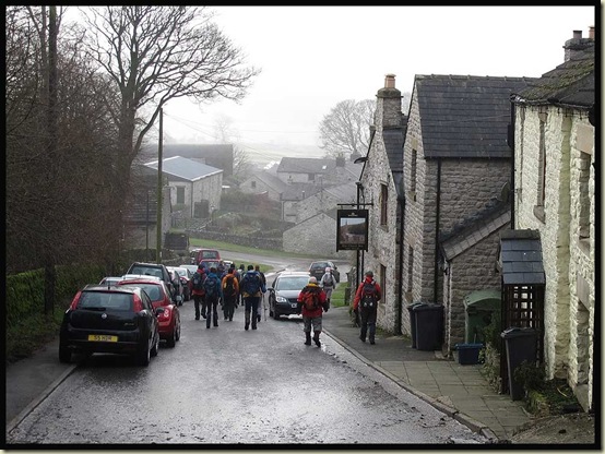
Passing the Church Inn - Chelmorton

After a while elevenses were taken beside a convenient wall at Town Head, with fudge, fudge brownies, and Phil's chocolate orange to supplement our diets.

Some grunting noises from behind the wall revealed some chatty residents.

Sue chats to a new friend

We continued towards Flagg, in unexpected sunshine.

Fields near Flagg

Unfortunately Flagg's hostelry was subjected to a devious by-pass.  Our leader, Sue W, had obviously gone tea total…

A skein of Canada Geese flew overhead, whilst a flock of Fieldfare and Redwings browsed in the fields nearby and a Kestrel hovered in the distance.

Our first strange encounter was an unusual mistbow (“a nebulous arc of light”) pictured at the head of this posting, which held our attention for some time and actually remained in position for much of the day.

Monyash was crowded with walkers, so some of us lunched at the War Memorial.

 Lunch at Monyash

Other members of the group pointedly sat elsewhere; we were being irreverent in their eyes.  But we thought the remembered servicemen would delight in the fact that we were using the perfect 'bench' afforded by their memorial to scoff our well earned lunch.

The nearby Bulls Head provided sustenance to those whose flasks had run dry.

The village cross – Monyash…

Monyash village cross

…dates from about 1340, when the village was granted a charter to hold a weekly market on a Tuesday and a three day fair to celebrate the festival of Holy Trinity.  The cross was probably wooden, and mounted on top of the stone shaft.  The circular holes in the base are where lead miners tested their drills after sharpening them at the smithy.

The end of the mistbow had the features of a rainbow, but most of its nebulous arc was the white of a mistbow.

The end of the rainbow

We came upon the remains of Magpie Lead Mine, near Sheldon.

Magpie Mine

According to the Peak District Mines Historical Society’s website:

The earliest recorded workings date from 1740, and the Magpie Mine was one of several such ventures working different veins in the same area. The miners had difficulty in keeping the workings free from water, but by 1824, a Newcomen type pumping engine had been erected on the Main Shaft. This led to the production of 800 tons of lead being mined in 1827, a record that remained unbroken until 1871.

Magpie Mine was also troubled by disputes with neighbouring mines over who had the right to work each vein. Miners from Magpie Mine and Maypitt Mine were both working the Great Redsoil Vein, and would light fires underground to smoke out their opponents. The arguments raged for years, both underground and in the courts. In 1833, three Maypitt miners were suffocated by the fumes, and 24 Magpie miners were put on trial for their murder. Several were freed immediately, and eventually all were acquitted because of the difficulty in identifying the individual culprits, and the provocative actions of the Maypitt miners themselves. It is said that the wives of the "murdered" men put a curse on the mine, and the effect of the disputes was to ruin the mine, which closed in 1835.

In 1839, the Magpie Mine, now incorporating the Great Redsoil workings, was reopened. A number of innovations were introduced, including steel borers, safety hats, safety fuse, and iron winding ropes, as well as a more regular pattern of shift working and payment for the workers.  The Main Shaft was deepened to 208 metres, and a 40-inch Cornish pumping engine was installed. When this proved inadequate, the manager proposed to replace it with a 70-inch engine, but the proprietors could not agree. Some felt that a sough (a drainage tunnel) would be a better solution, and appeals to the Duke of Devonshire to adjudicate fell on deaf ears.

Various attempts were made over the next 30 years, but it was not until 1873 that construction of the sough started. It took eight years to drive it from the River Wye near Ashford-in-the-Water to meet the Main Shaft, a distance of 2km.

Production of lead continued on and off into the 20th Century. An optimistic report in 1913 promised reserves of four million tons, which attracted businessmen from Sheffield and Glasgow to join forces with the owner. Their venture closed in 1919, and despite briefly reopening in 1923, nothing happened  with the mine until after the Second World War, when attempts to work the mine using submersible electric pumps were made.  A new winder - in reality a ship's winch fitted with a diesel engine - and a steel headgear were installed. Despite this more sophisticated equipment, no large body of ore was found, and with the end of the Korean War and the fall in the price of imported lead, the mine closed for the last time in 1954.

Back to the present…

After some uncertainty regarding the route, we passed through a vehicle showroom, where Paul was encouraged to make an offer for this fine machine with an identity crisis.

A Peugeot/Citroen 106

Sheldon looked a nice village, with home-made produce for sale, and a pub, around which our leader skillfully manoeuvred us.
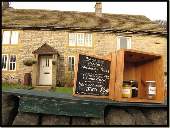
Homemade produce in Sheldon

Our second strange encounter of the day came at the top of Deep Dale, where some mountain bikers were lifting their equipment over a stile.

“They shouldn’t be here” – I could hear mumbling from some members of our group concerning the presence of bicycles on a footpath.  Looking down Deep Dale, we could see that it was very steep – hard enough to walk up, let alone push a bike.  One of the stragglers was huffing and puffing, and I’m sure I detected a voice emitting “Get a Move On” noises.

Yes indeed, this mountain biker was being encouraged to go more quickly, apparently by way of a combination of such noises and prickly love bites, by no less than a Green-cheeked Conure or Parakeet!

A green-cheeked conure

There’s a first for everything I suppose, we’d never seen this before, and those who (unbelievably) missed it didn’t believe the rest of us and claimed that my camera must be loaded with a photoshop tool!

And to be fair to these friendly mountain bikers, although it seemed like a narrow path, they actually had every right to be where they were – on a bridleway.

I've contrived to make the steep descent look deceptively flat!

Deep Dale

A nearby information board refers to this area as having been lived in since Neolithic (Stone Age - from 4000-2500BC) times, and a 'Dark Gully where demons lived'.

By the time we had crossed the A6 and ascended to Brushfield, the light was failing and the mizzle had recommenced. I was at the back, or I’d have led a splinter group along the track to the NW of Brushfield, before turning SW down the pleasant path across High Dale, avoiding any tarmac.  But in her wisdom our esteemed leader (thanks Sue W) took us down to the A6 for an unpleasant section of tarmac completely at odds with the excellent quality of the rest of the route.  Luckily, back at Taddington the pub was open and the beer was good, in front of a roaring fire, for the six of us who enjoyed a relax and a chat before heading home.

The Queens Arms, Taddington

Here’s our route – 20km with around 400 metres ascent.  It took us 6 hours, of which we were not moving for 2 hours.  The section from 8>1 is not recommended (by me at any rate) – I commend the track to the NE of High Dale, then the path across High Dale to Taddington for a very amenable conclusion to a good walk before reaching your 6th hostelry of the day…

Our route - 20km, 400 metres ascent, 6 hours (including 2 hours breaks)

There’s a mediocre (44 image) slideshow here, mainly for the benefit of those on the walk.

Here’s what the Garmin gadget recorded – feel free to use this data, Gayle (she forgot to turn her Gg on).

Friday, 6 January 2012

Weather

Sunrise from the Bridgewater Canal near Lymm

It has been a bit grotty recently in the weather department around Timperley, but today I set off in the dark on my bike during a rare dry interlude.

Sunrise from the Bridgewater Canal was really quite attractive.

Sunrise from the Bridgewater Canal near Lymm

Just out of shot is a dredger, clearing silt from the well maintained waterway.

Also just out of shot is my bike, covered in mud.

An inconsiderate thorn then delayed my return home, but at least my hands were warmer pushing the bike than they were riding it.  I hadn’t noticed the frost when I left home, lightly clad.

The purpose of the ride was to test my new lights.  They work fine, but I think the charger may be faulty – surely the battery should not still register ‘full’ after an hour’s use?

Cycling along the towpath was a bit like riding through treacle.  Now I know why I had a five month break from cycling between October and March last year, and a four month break the year before.

Thursday 5 January 2012 – Around Woolston

Gorse (Ulex europaeus) by Manchester Ship Canal
I nipped out yesterday after the wind and rain had passed, for a walk I didn’t think I’d been on before, but it seemed strangely familiar.

I’ve now searched my own blog to find, here, that “a report on the walk that Sue and I enjoyed around Woolston on 18 September (2010)will have to wait, or forever be forgotten.”

Well, until today it was forgotten.  It’s not a particularly inspiring walk anyway, but for the record – and there may be folk local to North Cheshire who may enjoy it – here’s the report on my repeat of the same walk.

It’s just a 15-20 minute drive over the Warburton toll bridge and down the A57 to Weir Lane, on the left just beyond Junction 21 of the M6 motorway.  A stroll down the ever narrower lane leads past a tarted up lock keeper’s house to the River Mersey.  The river used to be the main link between Manchester and the sea, and since the 1700s attempts have been made to adjust its meandering course and make journeys along the river shorter and quicker.  So at the end of the lane is the course of a canal, Woolston New Cut, which has only recently been abandoned and silted up.  Then a bridge took me over the river, which flows due west over a weir (hence ‘Weir Lane’).  This earlier short cut now prevails as the main course of the river. My route took me around a large curve and past a suspension bridge that now merely leads to an uninhabited island due to the shortcut having been dug.

It’s not a good time of year for wild flowers, but there was plenty of Gorse (Ulex europaeus) – pictured above.

The old course of the river leads right next to the embankment of the final solution for navigation to Manchester – the Manchester Ship Canal, dug in the 1890s.  The Mersey feeds into the canal in Salford, but by now has departed again on its parallel journey to the nearby coast.  My route headed alongside the Ship Canal for a while, as far as Latchford Locks, and this view to the west, the bridges in Warrington being either swing bridges or Very High Bridges.  Not many ships venture upstream here nowadays.

Looking down the Ship Canal from Latchford Locks

There’s quite some height in those lock gates – a good 20-30 feet.

Latchford Locks is the scene of much new house building, with just a few terraced cottages remaining from the days when they were probably situated across the road from a factory.

There are playing fields, and pathways strewn with unsightly litter.  The authorities here seem to have given up their losing battle with litter.  Back beside the Mersey, a well protected pipe bridge precedes a near 180 degree bend in the river that leads eventually to Kingsway Bridge, near the centre of Warrington.

Across the bridge, my route took me down the true right bank of the river, with the winter sunshine bathing the scene with unfamiliar light.

The River Mersey at Woolston

I was supposedly following the route of the Mersey Way, a footpath that leads from the east of Warrington for about 35 km to the Mersey Estuary.  Like many things Liverpudlian, this may have been a good idea at the time, with a fair sized budget, but no provision seems to have been for maintenance of the facility.  So nowadays the information boards are blank, the paths are overgrown, signs are missing, benches and picnic tables are rotting, and litter remains uncollected.

However, that hasn’t discouraged the wildlife – perhaps the opposite - there’s lots of it around here, with Woolston Eyes, a major dumping ground near the start of the walk for silt from the Ship Canal, providing artificial marshlands for huge flocks of geese, ducks, waders and gulls.

A family of Tufted Ducks gathered protectively on the river.

Tufted Ducks on the Mersey

After a tricky but avoidable section of path, where recent winds had blown the robust but light and hollow stems of what I assumed had once been Himalayan Balsam across the path, another bend in the river hailed the appearance of the remains of Woolston New Cut, the ‘short cut’ canal mentioned earlier.  My path took me back to Weir Lane via the towpath. 

There’s a bit of water at the western end of the Cut.

Woolston New Cut

Soon an avenue of young trees leads off into the distance, with no sign of any water.  Nor were there many people about.  Despite being near the centre of a large town, I encountered just two dog walkers in over two hours of walking.

The 'towpath' by Woolston New Cut

The water has gone, but the cut has been taken over by several acres of bulrushes as we approach Weir Lane and the end of this short stroll in the sunshine.

Bullrushes in Woolston New Cut

Here’s the route – 12 km with very little ascent, taking 2 to 3 hours.

My route - 12 km with very little ascent in 2.25 hours

There’s a slideshow here, for anyone who wants to learn a little more about this area.

Thursday, 5 January 2012

The TGO Challenge 2012

The outline of Martin and Sue's 2012 TGOC route

Here’s a first glimpse of the route across Scotland, from Ardrishaig to Aberdeen, that Sue and I have plotted for this year’s TGO Challenge.  It was vetted, a few weeks ago, by Alan Hardy, who made some helpful observations as to antiquities we may encounter en route, but no adjustments to the straightforward route were necessary.

It’s quite long, at almost 400 km (250 miles) nearly 50 km longer than we’ve done before, but with only about 11,500 metres of ascent it’s rather less undulating than any of my/our previous crossings.  Some 20 ‘hills’ are included, but some of these are small protuberances that don’t appear on any ‘list’, and just 2 Munros and 1 Corbett are planned.  One of the Munros is Schiehallion, on 17 May, in relation to which I’ve agreed to write a short essay for the Munro Society, who are compiling a 10th Anniversary Anthology of ascents of all the Munros in the period from 1st January to 30th September 2012.  So we’ll be pleased to see anyone up there around 11.30 to 12.30 on 17 May.  Medical Supplies and Shortbread will be available.  You could even leg it over from Alan Sloman’s cheese and wine party a couple of days earlier, but we’ll be setting off from Bunrannoch House at around 8 am.

I’ve still not tidied up the blog postings and photos from last year’s Challenge, but the following images provide a flavour.

Firstly, after walking 30 km up Glen Feshie and over to the Linn of Dee, my companion, ‘Poor Michael’, collapsed in a heap, to be greeted by Judith Barnes, on her way down to Mar Lodge.  “Where are you going?” asked Judith, who then seemed puzzled by my response - “Ballater”, as we headed up Glen Lui towards Derry Lodge!

Judith and 'Poor Michael' in Glen Lui

Cheese and wine features strongly on the Challenge, and the participation of Mr Sloman is not compulsory.  A few days later, at Water of Aven (near Mount Battock) ‘Poor Michael’ and I were joined by Roger Boston, and brother and sister, Markus and Silke – all the way from Austria, for an impromptu gathering in blinding sunshine at ‘Chez Phreerunner’.

Cheese and wine on the TGO Challenge

Happy Days – two of many…

Our 2011 route plan, and links to all my TGO Challenge routes and reports, albeit requiring a bit of editing, can be found here.

Now then, the rain is easing; where shall I go today?

Wednesday, 4 January 2012

2012 – A Gentle Start

Jake - 8 months
Given that the weather has been pretty atrocious, and the forecast was gloomy, Sue and I decided on a rare New Year’s Day lie in, rather than our usual trip to somewhere high.  There seemed little point in using a tank of petrol to get to the top of some hill or other where we would be immersed in view inhibiting clag.

New Year’s Eve saw us lunching together with the pixies (who are now probably too old to appreciate that description) and Kate and Jacob, now eight months.  Those of you who can read upside down may correctly surmise that Jake’s mother is an optimistic mathematician.

The little boy becomes more interesting by the day…

Jake and Kate

Anyway, with mum back at work, he’ll have to fend for himself over the coming months.  I’m sure he’ll manage fine.  There’s a very small slideshow here.

After the NYD lie-in, we did of course observe our tradition of a walk, even if no hills were to be involved, and we were pleased to be joined by JJ for a stroll down the Bridgewater Canal and the disused Warrington and Altrincham Junction Railway as far as Warburton.

We started by lingering on Timperley Bridge whilst JJ finished his breakfast at home.  So this is the first image of 2012.  The first of many!?

New Years Day at Timperley Bridge

This gent appeared to be enjoying his NYD ‘sail’.

On the Bridgewater Canal

JJ duly joined us for the 9km stroll to the Saracens Head, our designated port of call for lunch and the afternoon.

John and Sue on the towpath in Altrincham

We arrived just as the rain started.

Outside the Saracens Head

It rained all afternoon.  We didn’t get wet.  Not externally, anyway. This was a traditional ‘session and sing’ accompanied by Hob Goblin.

Inside the Saracens Head

There were 30 to 40 folk in attendance, many of them, like Richard (below) and JJ, musicians and singers.

Richard Peach - musician

A fair old dent was made in the stocks of Hob Goblin, and there was a moving tribute to JJ’s mum, a stalwart member of this fraternity, who sadly passed away on Christmas Day.

Darkness fell, the rain stopped, the moon came out, and the three of us stumbled back to Timperley without recourse to any other means of illumination. 

It had been an excellent start to the New Year.

Yesterday a stroll into the village for provisions revealed a gaping abyss in the local retail sector.

Greengrocer's shop to let

Ian Moores, greengrocers, was empty, with To Let signs outside.  Whilst it wasn’t the finest of its type, this shop did provide a useful local service.  It’s a sad loss.  The nearby Co-op now needs to up its game.

Luckily, we do still have an ironmongers and ‘DIY’ shop, which apparently opened in 1907.  I wonder how much longer it will survive.  And there’s a bank and an excellent butcher.

The Ironmongers shop survives

Timperley was once the home of John Arnold, a stonemason.  He was landlord of this pub, which dates from 1840.

Stonemasons Arms

It’s also known as ‘The Naked Child’, but that’s another story.

HAPPY NEW YEAR, everyone.