The main purpose of this blog is to keep in touch with friends and family, and maybe entertain others with common interests, particularly in relation to the outdoors. We hope you enjoy it, and your comments are valued....
Sue and Martin in Mallorca 2019
On the Archduke's Path in Mallorca
Friday, 23 March 2012
Friday 23 March 2012 - Meall na Fearna (in a cloud)
It was foggy, but my main requirement was well satisfied by the thankfully open and well stocked conveniences in Comrie and Lochearnhead.
I didn't feel like driving much further, so went round to Ardvorlich House and set off optimistically up Glen Vorlich. Tea stops kept me going, but by the time I reached the boggy watershed extreme weariness had set in - Dunkeld Hilton Lassitude, I suspect.
The route up Meall na Fearna doubles back a bit before rising steeply over rough ground to the summit. At 600 metres I pressed on into a cloud, forgetting the guide book's advice that "the high undulating ground above 600m may cause route finding problems in misty weather". Correct!
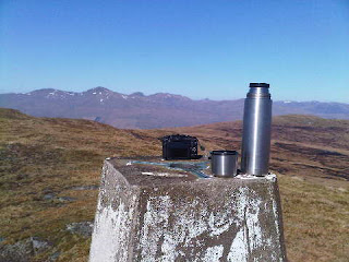
The Garmin gadget was switched on so it'll be interesting to see where my half hour's wanderings took me. But despite feeling unwell I eventually made it to the summit. I even found time to take a picture (above) which captures the ambience. I'd thought the fog would clear, but despite an optimistic comment from Louise, it didn't. Never mind.
The route down, on which I paid a little more attention to the map, was easy enough. But given that frequent stops were necessary and I'd resigned myself to a foodless day, the dinner appointment that I'd been looking forward to was aborted. Shame - it was with Sue's highly efficient PCT team that's being disbanded next week.
So I pottered back to Timperley after three excellent if fairly modest forays on which I didn't see a single other walker.
Tomorrow will be different.
In due course I may get around to an entry with some routes and a slide show - most of the pictures being from yesterday's wonderful outing on Creag Uchdag. The routes are now with the slideshow - here.
Thursday, 22 March 2012
Thursday 22 March 2012 - Creag Uchdag (and the arrival of Spring)
Today's objective, Creag Uchdag, involved driving up picturesque Glen Lednock, past a lone lady mountain biker - the only person seen 'on the hill' today - from the pretty village of Comrie. It's then a half hour walk up the road from the car park to the dam. On the way up there are good views of an extensive waterfall spreadeagled over some rocks below the dam.
The reservoir was less than full, and is overlooked by a well positioned bench dedicated to the memory of Charles G Robertson, who was involved in the dam's construction. Tea break number one was taken here, once the resident Oyster Catchers had adjourned to a safe position.
A further couple of hours saw me scurrying over the minor summit of Meall Dubh Mòr and up to the trig point pictured above. From this highest vantage point (879 metres) for miles around, the panoramic views were outstanding.
After lingering on the top for some time, a fairly quick descent - avoiding the slurpy bits - had me back down at the bench for tea break number three pretty quickly, though I paused for a while to watch some Golden Plovers, and also a pair of birds of prey, which I took to be Buzzards. There were also some smaller mouse hunting birds that I failed to identify.
Then it was back to base for a pleasant afternoon with my hosts, who are enjoying a very 'chilled out' week.
Sadly, this fine day on the hill was rather overshadowed by the receipt of some very bad news concerning the health of a good friend from University days.
And I'd like to wish Alan R a speedy recovery from his much less serious - albeit terrifying - trip to the 'doc'; thanks also go to my 'secretary', who has succeeded in unlocking the Salford slide show from the grasp of Google.
Slideshow now here.
Wednesday, 21 March 2012
Wednesday 21 March 2012 - Choinneachain Hill
Apologies to those who tried and failed to view yesterday's Salford Trail slide show. Sadly I've been unable to 'read' a barrage of 'Googlies' and I keep getting stumped. However, the link should now work. Enjoy!
I can't re-insert the link here due to my further lack of competence, in this case it's the dreaded Blackberry that I've failed to master.
Today's picture of Choinneachain Hill (on the right) was taken from the dam on Loch Turret Reservoir, just outside Crieff. It was a fine day for a hill walk, albeit a bit noisy with seriously vocal gulls. No people at all though, until I met a farmer feeding his sheep at the end of the 14km walk.
The sound of raucous gulls was soon replaced by the melodic trill of a curlew, as I sauntered along a pleasant track laden with frogs and their spawn. Then the 400 metre ascent was by way of a thin path, not marked on my map, beside a burn to the south of Ton Eich. After that a short heather bash took me to the hill's cairn laden summit.
There was very little snow up there at just under 800 metres. The hares, still in the pure white of their winter raiment, provided a rather amusing sight as they stopped and started in unison. To be fair, when stationary they probably looked like rocks from above.
Good views towards Ben Chonzie were enjoyed as I strolled across to Auchnafree Hill, which seems to me to be of diminutive stature compared with Choinneachain Hill despite the protestations of the Ordnance Survey.
Auchnafree Hill does however take first prize on the peat hag front. Some bog dodging was necessary.
But it was warmer and calmer than expected - hat and gloves were not required, the old Vapour Rise fleece proving ideal for the 'early Spring' conditions.
Meadow pipits tweeted high above me, but there was no sign yet of the wheatears having returned from their holidays.
An easy descent with fine views across Loch Turret Reservoir soon had me back at the car and emptying the dregs from my flask before setting off to tonight's Bothy, where a good dose of Chardonnay can be blamed for any unintelligibility within these scribblings.
Slideshow now here.
Tuesday, 20 March 2012
Thursday 15 March 2012 – The Salford Trail – Part 1 – Salford Quays to Clifton (nearly)
Last year the ‘Plodders’ section of East Lancs LDWA systematically walked the Salford Trail, breaking it into five stages. I missed the first of those walks, not actually being a member at the time, so Reg kindly agreed to keep me company for today’s re-enactment.
He turned up on time outside the Lowry Centre, with Anne and Nancy, and off we went, to be joined after a few seconds by Roy Bullock, whose brainchild the Salford Trail represents.
A cold grey blanket was sprawled over Salford, brightened in Salford Quays by a variety of stainless steel plaques embedded into the walkways by the canal, with statements like “Lasses took on men’s work for less than skivvy pay and when the war was over they were shunted outta way”.
Detritus littering a corner of the canal basin offered a prelude of what was to come – rather more litter than we expected, but it’s clearly difficult to control, and there’s been much progress from the days 100 years ago when the place would have been strewn with dead dogs and other less savoury items than those we could see today.
Staff at Salford City Council got wind of our feelings about some of the litter before this posting was drafted. It’s to their great credit that they are expressing concern regarding known issues and are looking for solutions even before I’ve said a word about it.
Good luck to them, it must be a tremendously difficult task to control litter in the urban environment, especially in an era when schools aren’t interested in educating the children on such non academic matters.
As Roy Bullock has pointed out after reading this entry:
’I remember some time ago in response to a litter problem a council
spokesperson saying "We employ hundreds of people and machines to
clean up other peoples litter it is not our policy to create litter" I
thought that those few words spoke a lot about the problem and I
really do sympathise with them over it.
Regarding the rubbish in the canal, as I said on the day of the walk,
Salford being at the thick end of the river Irwell gets everybody
else's rubbish. The rivers Croal, Roch, Irk, Medlock and Tib all empty their unwanted flotsam into the Irwell, which finds its way to Salford Quays, so it is an unending problem. Yesterday's lolly stick in Bolton could be in Salford Quays tomorrow.’
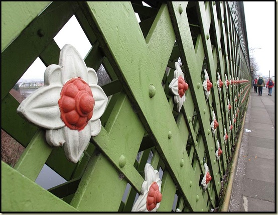
After a while we reached the first of many brightly painted bridges, the Trafford Road swing bridge. It no longer swings, but the giant cog wheels by which the bridge used to be turned using hydraulic power remain in situ.
Our walk was now free of roads for some distance as it followed the waterway known as the Erie Basin, with Manchester's Beetham Tower merging into the cloud just a few hundred metres away from us, whilst cormorants, swans and a variety of ducks were active on the waterway.
Some impressive new signs and information boards are being installed. We hope there is also a follow up budget for removing the inevitable graffiti.
We passed the former Colgate Palmolive plant in the heart of Salford Quays. 'Soapworks', is apparently "set to become an iconic building within the North West Office market".
A lot of effort has been and is being put in to develop the area in a tasteful manner, whilst retaining and renovating some original features.
We entered an area of 'uncontrolled graffiti' where not even the scrapyard had escaped! Then a section of ‘supervised’ graffiti saying nice things and mentioning councillors… (have a look at the slide show, and form your own opinion).
Woden Street footbridge is known locally as Mark Addy's Bridge, after the man who saved more than 50 people from drowning in the heavily polluted River Irwell, before his own death as a result of swallowing some of the polluted water whilst carrying out his final rescue.
Shortly beyond the spot where the River Medlock finds its way into the Irwell on the other side of the river, there’s a narrow stone bridge which we approached on tiptoe, as the quiet basin behind it is a haunt of kingfishers. Sadly they they evaded us today. The basin was used by Salford Corporation Cleansing Department, before the days of flush toilets. Collections of 'night-soil' were brought here to be mixed with road sweepings and fine cinders before being transported along the river to farms on Irlam and Barton Mosses.
Soon we were pausing for a while to admire the stalactites. Yes, on a bridge in Salford!
A canal used to run from here to Bolton and Bury. Great efforts are being made to reopen this canal, but a lot of work is still needed. We passed a plaque in memory of Margaret Fletcher (1949-2006) a driving force behind the project.
Across the river/canal, the Beetham Tower glances down on a short lived link with the Bridgewater Canal, constructed as part of a 'toll war'. Special permission is now required to explore that section of canal, which came out in the basin next to where the Bridgewater Hall now stands.
The section of waterway bordering with central Manchester was fairly littered. With bridges as well as rubbish.
A visit to the Mark Addy pub (he's pictured at the entrance with his bravery medals) saw us enjoying coffee, with toast and beef dripping - a speciality of the house. Those of us who had it were left with the taste of beef dripping for much of the day, but we didn’t run out of energy!
Just beyond the Mark Addy, we came upon the resplendently refurbished statue of Joseph Brotherton (1783-1857), the first Salford MP, whose wife was the author of the first vegetarian cookbook. It has recently been rescued from the 'heathens across the river' and now stands proud at the end of New Bailey Street, where our route left the waterway (although a waterway path is under construction, and according to Roy Bullock on 25 March has now been opened).
“Salford must employ an army of bridge painters!” That was a fairly unanimous comment as we passed the beautifully painted bridge parapets by Salford Central railway station.
Spaw Street is run down at present but must once have been a vibrant spot – it’s named after the place nearby where Salford once had a cold water mineral bath, or spa. The bath was fed by a natural spring and people took its water at a time when they believed it to be a cure for all ills.
Sacred Trinity Church, Salford's oldest, dates back to 1635. It stands behind the world's first gas lit street. That was in the early 1800s.
Here they are - Reg, Anne, Nancy and Roy - on the site of the former Gravel Lane Bible Christian Church where the inappropriately named Rev William Cowherd developed the idea of food without meat, leading eventually to the formation of the Vegetarian Society by Joseph Brotherton on the principles set by Cowherd.
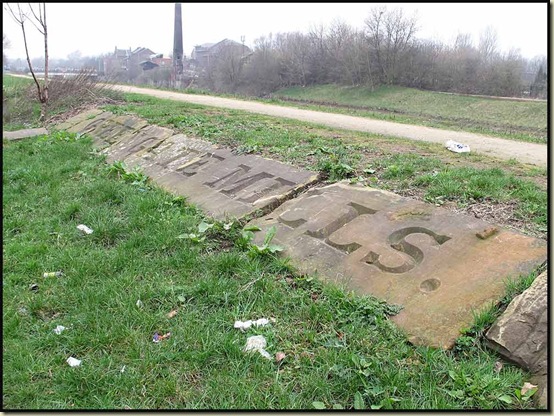
Returning to the banks of the Irwell, the bank was littered with piles of old stones from the mills that used to grace its banks. Here, amongst the litter, some of those old stones have been reclaimed and re-laid.
We continued on along the left hand bank as far as Adelphi footbridge, with its view of the Adelphi weir, beyond which there's a large meadow with a pond. We paused here on well built benches for lunch and brownies, before circumnavigating the meadow, which is surrounded by University buildings.
The Willow was blossoming.
Another smartly painted bridge took us into Peel Park, perhaps the world's first inner city park. Named after Robert Peel, it dates from 1846 and was the first of three parks opened on the same day.
Tufted ducks frolicked in the river below the Frederick Road bridge - scene of a proud mayor!
Plaques on each end of each parapet proclaim the importance of Mayor Robinson.
Back on the left hand side of the river, having crossed the footbridge that collapsed in 1831 when crossed by soldiers walking in step – the vibrations caused the suspension to fail, and they were all catapulted into the river, we strolled amiably along a new pathway.
After crossing Gt Cheetham Street by Cromwell Bridge, and fame for another mayor of Salford, R Husband, we continued along a steel fenced path past student accommodation under a verandah of blossom.
Across the meadow land that was once Castle Irwell Racecourse, we came to a humped back footbridge that looks over to a block of flats called the Peninsula Building. It was here that CAMRA was conceived.
Now we embarked upon an interesting two mile loop, first across the site of an old Manchester Golf Course, past mounds that used to be bunkers. Bulrushes have taken hold in places, and deer can apparently be seen in these parts. A return to ‘wild land’. In the middle of Salford!
We moved on up to an area with long views down to the racecourse. This is The Cliff, known locally as the Landslide. The last landslide was in 1927 and it took with it part of the main road that carried the tramlines – that’s the cobbled street pictured below.
You can still see the iron rails laid between the cobbles and the street paving. These were to enable horse drawn vehicles to brake against the rails as they descended the steep slope.
Wandering on, past the Bishop of Manchester’s house, and having touched upon the district of Higher Broughton, we moved on to Kersal, and St Paul's Church.
A tour of the churchyard revealed much of interest. It houses the vaults of the Holt brewing family, and their relatives the Kershaws who now own the brewery. Edwin Waugh (1817-1890), the Lancashire Dialect poet, is also buried here.
Moving on, we strolled over Kersal Moor whilst Roy continued to educate us on all matters Salford – apparently this moor was the site of the first racecourse in Salford in the 1680s, before racing was transferred to the Castle Irwell course. There was a Great Chartist meeting here in 1838, with around 300,000 people in attendance, and before that, in 1804, a duel was fought, between Major Philips and Private Jones. Up there, we were at the dizzying height of 260 feet, on the very summit of the City of Salford.
"Take the rising path on the left next to the nursery school" says Roy in his route description. It will have to be edited. Unless they build another school there. Mind, you could just about make out the playground, and the sign for the school was still in place.
Back at the River Irwell, via a housing estate, we were joined at Jubilee footbridge by a young lad who was visiting a friend after work. "Not me" he says, agreeing with us about the sad state of Salford's litter problem. Just after this we meet two lads carting a load of wire and tubing along on a bike. I think we were all too gob-smacked to react.
A 'stadium' sculpture on the east bank of the Irwell apparently cost a fortune. Opposite, on our side of the river, is the point where in 1944 a Lancaster bomber crashed into the end houses of Regatta Street, killing the airmen and destroying several houses.
A few metres further on, from behind the Hercules Powder Company, appeared this rather unpleasant looking effluent. I promised to report it. I have done.
Next, we passed the 'stand' from where the regatta could be watched. I don't think they have the regatta here any more, but Goosanders were busy flying up and down the 'straight'.
The riverside path passes the huge expanse that is Agecroft Cemetery. We noted a memorial with the black rosette in front of it as being that of Peter Lobengula, the 'Black Prince', who came to Salford with the Savage Africa Show in the late 1800s. He stayed behind and settled in Salford, claiming later that he was the son of King Lobengula of Matabeleland.
We'd planned to go to Clifton, but the scenic delights of this walk had distracted us sufficiently to need to call time at the boundary of Agecroft Cemetery, and walk up Agecroft Road to catch the number 8 bus at the A666 in Pendlebury. But not before studying the pipework of the Thirlmere Aqueduct - two huge pipes and the ornamental ironwork of the Water Works bridge that dates from 1832.
A little further up the road the aqueduct seemed to have sprouted a third pipe! I'll leave that for Reg to explain…
Here’s our route for the day – about 21km with very little ascent.
That leaves me with Agecroft to Clifton to complete the whole walk – that’s about 2 miles, on which I’ll report in due course, together with an index covering all my Salford Trail walks.
Meanwhile, there’s a slideshow of today’s walk here. It’s a long but worthwhile set of images, for those who may be interested.
All my Salford Trail postings can be found here, in reverse order, and most importantly, Roy Bullock’s labour of love, with a host of fascinating additional information, is here.
Enjoy the Salford Trail, everyone.
Monday, 19 March 2012
Wednesday 14 March 2012 – The Cloud and Gun Hill
Last Wednesday saw me heading over to Buxton for a session with my old workmate, Chris, who is now at the Health & Safety Executive’s head office.
On the way I enjoyed a stroll up The Cloud from Rushton Spencer, where a Staffordshire Way car park behind The Knot Inn provides a good base for walks in this picturesque part of Staffordshire.
The 92 mile Staffordshire Way passes through here, and the Knot is the emblem of that route.
This walking route utilises the trackbed of the North Staffordshire Railway. The line was opened in 1849 as part of the Churnet Valley line and remained open until passenger services were withdrawn from the northern end of the Churnet valley line in 1960. Freight services lasted until 1964 when they too were withdrawn and the track lifted. Here it is today.
After about a kilometre my route joined the Gritstone Trail, and also the Dane Valley Way, all three footpaths coinciding at this point where, curiously, a signpost indicates ‘LYME PARK 18ML/30KM’. I can’t recall seeing many distances marked in kilometres on UK footpaths – perhaps Staffordshire is leading the way.
The Cloud made its appearance out of the gloom as I strolled along the deserted path, to the fairly constant sound of pot shots at clay pigeons being taken at nearby Cloudside Shooting and Sporting Club.
Towards the summit of The Cloud an array of ten signs awaits those brave enough to tackle the final few metres to the summit (don’t bother if you have a hang glider or a bicycle).
There are views far and wide from up here, as can be seen from the orientation point pictured below, but you can see that ‘The Cloud’ lived up to its name today – the Cheshire plain should have been visible in this photo. But it wasn’t…
I could just make out the outline of Mow Cop, five miles away, and whilst the low veneer of mist never really cleared, the sun did try to put in a muted appearance as I made my way around the wood to the south of The Cloud, and returned towards Rushton Spencer via a selection of well-marked field paths.
Saint Lawrence Church has a timber framed church possibly from the 14th century existing within the walls of the late 17th century stone building. The date above the east window is 1690 and above the south doorway is 1713. I came across the church, with its weather-boarded turret, in an isolated position in fields above Rushton village. Anciently, apparently, the church was known as the Chapel in the Wilderness.
The grave of Thomas Meakin is in the churchyard. Meakin was thought to have been poisoned by his master, an apothecary, for having fallen for his master’s daughter. After exhumation, Meakin’s body was brought back to his home village of Rushton for burial but it was set apart from others by the fact that it is the only grave to face west.
Here’s the view east, looking down through weak sunshine to the village of Rushton Spencer and the end of this little excursion.
The route I took, shown below, was about 11km, with around 300 metres ascent, easily completed within 3 hours. A good half day amble if you happen to be in the area, and hopefully you’ll choose a day when the ‘Sporting Club’ is closed, though after a while you’ll probably cease to notice the popping of the guns.
With a few minutes to spare before meeting Chris in Buxton, I nipped up Gun Hill, a fairly nondescript protuberance to the south of Danebridge. Whilst it was pleasantly sunny, misty cloud still obscured the views.
It was good to keep in touch with Chris, and later to meet up with TGO Challenger Andy Howell and others at Stockport Walking Group’s weekly get together, where Andy, apparently commissioned by the tourist boards of Ireland, London, Birmingham and Rio de Janeiro, was showing a few of his photos.
What a pleasant day, even if I was a bit peckish by the time I got home!
Friday, 16 March 2012
March 10/11 2012 – A Rentahostel Weekend in Wooler
Well, it hardly seems a week since we were setting off on this trip!
Last Friday saw about 40 sundry persons accumulating at Wooler Youth Hostel, for a weekend in ‘sunny’ Northumberland.
The ‘Local Pub’ Arms met our little sub group’s requirements, with a good value two course offering. Then GS’s 'pre-booked’ group of about a dozen turned up, much to the surprise of the restaurant staff, who had received a call from the ‘Local Pub’ Arms in a neighbouring village along the lines of ”Have you seen our customers?” The answer of course was “Yes, they are eating here.” The (other) ‘Local Pub’ Arms were not amused and are no doubt being overwhelmed by GS’s apologies for this stupendous ****-**!
With about 20 cars between us and room for only just over half of those in the car park, also used by residents of a nearby house, ‘Mayhem’ could accurately describe Saturday morning’s assembly outside the hostel. Some left to attempt a linear hill ‘bagging’ route, whilst 19 of us assembled for a lower level outing from Wooler.
These three looked cheerful enough, as they gathered for the leaderless stroll.
Various maps were surreptitiously fondled as we headed off along the St Cuthbert’s Way footpath, which I’d thought was the intended route to the Iron Age fort on Humbleton Hill that I was told was our first destination.
So when everyone paused at a path junction, I strolled on along the St Cuthbert’s Way path, expecting to be followed, unaware that an intermediary destination, Coldberry Hill, had been inadvertently inserted into the plan.
Anyway, I enjoyed a potter around the remains of the fort, which possibly dates back to several hundred BC, before all 19 of us gathered for elevenses on the sheltered side of the hill on this somewhat chilly day.
"Nice tea" says Sue.
‘When’s she going to pass the shortbread?’ ponders Paul.
It was altogether Very Jolly (see slideshow – link below - for more pics of people being Very Jolly).
Further on, another 'Fort & Settlement' was visible from the summit of Gains Law (319metres), with good views back to Humbleton Hill and the dry valley to its south.
After some discussion a consensus was reached whereby we would continue to be leaderless but would follow the St Cuthbert’s Way path - a 100km (62.5 mile) long distance walking route across the Scottish Borders to the Northumberland Coast following in the footsteps of St Cuthbert - all the way to Tom Tallon’s Crag. Here’s part of the assembly, striding out along the broad path, with the Northumberland lowlands stretching towards the coast in the background.
There’s a high (815 metre) hill near here called The Cheviot. It has a reputation for trapping the unwary in a morass of mud and bog, and on this day you could add cloud to that list, so we observed its grey flanks with some pleasure that it wasn’t on our itinerary. Nor was it worth capturing on ‘film’ (or ‘phillm’ as they pronounce it in this far flung extremity of the UK).
All apart from Colin had attentively listened to the plan to conquer the immense boulders of Tom Tallon's Crag – at 353 metres the highest summit, if not the high point, of this walk, so whilst he hid out of the wind in some heather by a path junction, the rest of us enjoyed a break in the shelter of Tom’s two foot cliffs. It was still early, so lunch was delayed until we had trudged along a few more little red dots to Commonburn House. A quick dash from the vanguard ensured a nice grassy bank, out of the wind, for lunch, somewhat to the disgust of a group of youngsters heading for the same spot. There were quite a few people about in this area.
Some of our group chose to head directly to Broadstruther, as planned (apparently), from here, leaving about a dozen of us to enjoy a longer walk that took us first past one of several walled enclosures in the area, still completely intact, presumably used for corralling livestock.
A rough track across the moor delivered us to the edge of a wood above Goldscleugh. Here something 'spooked' Sue W, who rushed up a tree in a bid to escape.
A good path led through the wood towards Goldscleugh, where the blare of a hunting horn was unmistakable as we looked down to the dilapidated farmstead to see a jolly band of hunters with their pack of hounds. Whilst seemingly a bit ‘posher’ than our rag tag (Colin excepted, he has a big posh car) band, the hunters – who had no booty – couldn’t have been more friendly.
“We were drinking and chatting whilst the boss got bogged down, the fox made a break for it and the hounds got lost” – I think that’s the gist of what she was telling us.
The route from Goldscleugh led up to a final tea break after a few dark mutterings as we negotiated our way along a ‘path’ that had once run through the trees of a now felled forest.
Eventually we reached a cottage at Broadstruther, which those on the 'short route' had passed some time earlier. At first we thought it might be a bothy, but this place was far too smart to warrant that description.*
Wide paths and sturdy bridges then ensured an easy passage back to Wooler. Just as well, as people were starting to flag. Some were nearly asleep.
Here’s Saturday's route - 27km, 700 metres ascent, 8 hours (subject to a short cut from point 5 to point 7 by a few people).
Fortified by Sue’s Saturday night soup, stew and cheesecake, the assembled gathering, apart from those who had gone gone ‘sick’ (though Sue isn’t getting the blame for spreading chicken pox), managed to summon the energy needed on Sunday morning with which to consume their second ‘Ken’s Big Breakfast’ of the weekend.
Then some folk went home, but the majority pottered over to Craster, where we set off along the well worn path towards Dunstanburgh Castle.
There were quite a few of us on this walk!
Embleton beach provided a sunny spot amongst rock pools for elevenses and a sunbathe or paddle for everyone except me. I had urgent business back at Craster having left the fridge turned on. Flat battery averted, I returned in time to join those who hadn't succumbed to the lure of their long journeys home, for the final stroll over firm sand (pictured at the head of this posting), with trees, on the approach to the fleshpots of Newton.
It was 'beer o'clock' by the time we reached the Ship Inn, from where some of us left with sunburn.
Pied Wagtails skittered across the roofs at the back of the pub.
Toads were abundant on the walk back to Dunstanburgh above the beach. They were piled on top of each other like little dumps of dog poo. Care was needed. Clumsy feet squash toads!
Dunstanburgh Castle drew ever closer, and here Sue and I said our goodbyes and went off to explore the castle (see slideshow) whilst everyone else went on their way.
Then we also went home...
Here's our route - 14km, 70 metres ascent, in all of 4 hours.
There’s a full slideshow here if anyone is interested.
Finally, here’s Ken’s ‘Bird Report’:
Saturday: Skylark, Lapwing and Curlew returned to the moors for breeding.
Sunday: Yellowhammer and Linnet, Oystercatcher and Eider at Craster; Fulmar, Razorbill and Kittiwake returned to sea-cliffs to breed. Seal basking in the bay at Craster as well.
Monday, 12 March 2012
Gear Review - Lowe Alpine Nanon 50:60 Hyperlite Backpack
I’m very lucky in that over the past year or so Webtogs have been sending me useful items of kit to review. I was therefore delighted when Gareth agreed to send me the closest of the rucksacks stocked by Webtogs to a direct replacement for the Quest.
[Note that on 5 September 2012, Webtogs Limited went into liquidation, but its business has legitimately been continued in the name of Dorset Mountain Sports Limited, t/a Webtogs, with whom I have had no contact whatsoever, nor did the liquidator of Webtogs Ltd respond to my enquiry as to whether any members of the public had lost money as a result of the liquidation.]
So way back in October last year the Lowe Alpine Nanon 50:60 Hyperlite Backpack plopped through my letter box (well, perhaps it’s not quite that small!). At approximately 1400 gm the Nanon is perhaps slightly lighter than the Quest, and it is more compact, topping out at about 60 litres capacity compared with the Quest’s 72 litres. However, the lightweight Dyneema fabric of the Nanon feels to me to be rather more robust than the old Quest’s less durable nylon fabric.
I’ve delayed reviewing the rucksack to give me time to make objective comments rather than a ‘first impressions: brilliant’ sort of review, but I also have to admit to not having used it all that much. Yet! It’ll get a lot more use in the coming months, after which I’ll append appropriate comments to this review.
I have used it on an overnight backpacking trip (pictured above – not very well packed, and I lowered it a little after the pictures had been taken), for which it was perfect. Once I’d spent a few minutes adjusting the straps I found it extremely comfortable, and it had plenty of room for all that I needed. I’d have been quite happy to fit another couple of days’ food into the sack, but beyond that I may have been struggling. I don’t however travel particularly ‘light’, and some of my gear is fairly bulky, so I reckon that someone who pays more attention to carrying lightweight gear than I do might get their kit and up to 5-6 day’s provisions into this bag, especially in summer.
The rucksack has also been used as a day sack (as above – recognise the hill?) for a number of winter walks, on which I tend to load a fair amount of extra gear – gloves, hats, down jacket, emergency shelter, etc - in case of ‘problems’ (some of my companions being less prepared than others for wintry conditions). I’ve found it brilliant for this as the straps allow it to compress to a small size – you really don’t realise that you are carrying a 60 litre sack, and the ice axe stashes neatly rather than floating about in mid air.
Design
The Nanon’s main compartment sits below a removable, floating lid with a large and easily accessible external zipped pocket with a key clip. On the underside of the lid is a secure internal lid pocket. Two small hip belt pockets accommodate items such as a mobile ‘phone or a wallet, but these wouldn’t be big enough for GPS units much bigger than a Geko. The main body of the rucksack can be entered from the bottom via a long zip – this is a large ‘plus’ over the Quest for me as it enables me to load the rucksack before striking camp, and the tent can then be slotted into the bottom of the rucksack without the need to remove the other contents. There’s a deep pocket on the front that’s suitable for all the provisions and snacks you may wish to have ready access to during your walk, and behind that pocket is a cavernous space in which I have been keeping my waterproofs, but others may wish to stash their tent here. Other features include extra external lashing points, large stretch side pockets, an SOS panel, ‘unique’ walking pole tip grabbers for secure storage, reflective logos, hydration pocket, and a ventilating harness.
I noticed one review that raised concern about the robustness of the buckles, but whilst these, and the straps, have clearly been cut down to minimise weight (“10mm web reduces weight with no loss of function” – according to the manufacturer), they appear to me to be well made, securely attached, and hopefully they will prove to be durable.
On the hill
I soon managed to adjust the rucksack to a comfortable position – it comes with clear fitting/adjustment guidance. The manufacturer has clearly put considerable effort into achieving a comfortable design, and they want customers to take advantage of this by following their guidance on how to achieve a comfortable fit.
I didn’t need to make significant adjustments to switch the rucksack from its role as a backpack for a multi-day wild camping trip to its role as a winter day sack, apart from drastic tightening of the compression straps.
At risk of being repetitive, here’s Lowe Alpine’s blurb on the product:
“The Nanon targets those people who want a lighter packs but also want functional features that help to organise their loads during the trek.
Key Features and Benefits: • Super lightweight pack that still carries well
• Lightweight but durable Dyneema fabric body
• Lightweight Centro adjustable back for maximum comfort from a precise fit
• Lightweight version of AdaptiveFit hip belt ensuring maximum comfort
• 10mm web reduces weight with no loss of function
• Airflow mesh in back panel reduces moisture build up
• Front compression pocket for wet gear or additional quick access items
Additional Features: Extra external lashing points, large stretch side pockets, key clip, lid lash points, SOS panel, secure internal lid pocket, unique walking pole tip grabbers for secure storage, reflective logos, hydration pocket, ventilating harness, hip belt pockets, extendible lid.
Volume: 50lt+10lt extension=60lt 4000+600cu.ins
Load Zone: 10-15kg / 22-33lb”
My comment on that would be that I feel that it would cope with a little more than 15 kilos if necessary. I also note that there’s an ‘XL’ version for people with long backs, though Lowe Alpine don’t seem to say how long your back needs to be to require this version.
Practical Use:
- I’ve used this rucksack for backpacking and for winter day walks over the past five months. It has been a pleasure to wear for both those activities
- I’ll expand this section of the review in due course for comments of the ‘used and abused’ nature (see below)
- Webtogs’ price was £134.99 in March 2012, including a discount of 10%
- There are numerous alternatives, so much dependent upon personal requirements and preferences that I will leave readers to take their own counsel
- It's now early 2015 and this is still my rucksack of choice for backpacking. It accompanied me across the GR10 route in the Pyrenees for two months in 2013, and it will shortly embark on its fourth TGO Challenge - a two week backpack across Scotland. I still think its an excellent piece of kit, though I have heard complaints from people taller than my 5 ft 8 inches - they say the back length of the sac is insufficient lengthwise, so they have sought alternative products. I don't know whether they investigated the XL version referred to below?
August 2015: just back from walking GR11 (Spanish Pyrenees, coast to coast) in seven weeks, during which this rucksack's life ended. The straps started to deteriorate, with the attachment shown below failing. Luckily there was a piece of elastic with which to effect a temporary repair.
Then the long zip on the rucksack that enabled insertion of the tent or other items without having to empty the rucksack - it failed. Whilst this zip was very useful, once it has failed the rucksack is pretty useless as the contents are prone to falling out. Luckily I managed to get the zip to grip, but every time I unzipped it another half hour would be spent trying to get it to grip again.
You can also see that the Dyneema fabric has started to show serious signs of wear, with some holes appearing.
Time to recycle this item....
Conclusion:
- The Lowe Alpine Nanon 50:60 Hyperlite Backpack is great for use as a compact backpacking rucksack or a voluminous day sack, and will also be ideal for Alpine hutting trips or similar
- It’s well constructed from what appear to be quality components, and comes with clear instructions on how to achieve a comfortable fit. There’s an ‘XL’ version for people with long backs
- I like the ‘bells and whistles’ whereby this sack has lots of features for very little added weight, including a zip that facilitates the stashing of a wet tent at the bottom of my load without having to first empty the sack
- Thanks have to go to Webtogs for providing a piece of kit that is a pleasure to use and will accompany me on many trips in the days to come
- Can you tell? I’m impressed with this one… initially, anyway
- It was good while it lasted, but durability was not this rucksack's strong point. The indestructible Karrimor Jaguar 65, 20-30 years old, will resume it's position as my rucksack of choice.
Note: Whilst the rucksack was provided by Webtogs, this review, over which I have total editorial control, is totally independent of that on-line retailer.
__________________________________________________________