Sue and Martin in Mallorca 2019

Sue and Martin in Mallorca 2019
On the Archduke's Path in Mallorca

Friday, 6 April 2012

Thursday 5 April 2012 – Canterbury, and a North Downs Way Bimble

Canterbury Cathedral Quire

Sue had never been to Canterbury.  Today’s overcast skies allowed her to remedy that omission.  She enjoyed the cathedral, and the walk through gardens by the River Stour was very pleasant, but much of the town resembled any other medium sized conurbation in the UK.

Canterbury Cathedral

We adjourned to the nearby village of Wye, with its view towards the Millennium Crown on a nearby hillside, before parking at the top of the hill on the route taken by the Long Distance Path known as the North Downs Way, which in this area also bears the name of ‘European Route E2’.

North Downs Way and E2 signs

I wonder whether we’ll find similar signs on the E5 route we plan to take in a few weeks time.  We certainly won’t be taking a laptop computer with us on that trip!

A brighter day would have shown the North Downs in a better light, but despite the chilly gloom, and a scarily vacant picnic table from the Marie Celeste, we enjoyed the empty countryside on this pleasant amble.

North Downs picnic bench

Those invisible skinny-legged picnickers need very long arms to reach the condiments, but from what were they hiding?

Here’s our route – 10 km, with 300 metres ascent, taking 2-3 hours – one of a plethora of walks you could devise in this well footpathed part of the world.

Our route - 10km,300 metres ascent, 2.5 hours

Sadly, that’s it for now as we imminently embark on a long journey northwards, so after any interlude that we may or may not report on, it’ll be back to the delights of the Lancashire Trail and the Bridgewater Canal next week…

Thanks go to Gemma and Ed, the owners of Waters Edge, for providing such a delightful abode, via English Country Cottages, for our week in Kent.

Thursday, 5 April 2012

Wednesday 4 April 2012 - Scotney Castle and some Kentish Bimbles

Bluebells at Forsham - 4/4/12

Much to our surprise we were greeted by yet another sunny day, so wet weather plans were deferred in favour of a trip to nearby Scotney Castle, which may not yield childhood memories for many of my readers as it was only relatively recently opened to the public.

We arrived early, making time for a 7-8 km walk around the circumference of the estate, using the marked ‘Parkland’, ‘Woodland’ and ‘Hop’ paths.  Here’s Sue, dashing on ahead in the woodland…

Onthe woodland walk at Scotney Castle

… and here’s where they grow the hops for the local Westerham Brewery’s beer.

Hops at Scotney

By the time we got back the tea room was open for us to refuel before embarking on a tour of the house, built in 1837 for Edward Hussey III, whose last descendant lived there until 2006.  It has a rich history, being renowned in its heyday for lavish entertainment. 

In later years the upper floor was divided into flats, one of which was surreptitiously occupied by Margaret Thatcher when she was leader of the opposition, as her safety in her nearby matrimonial home couldn’t be guaranteed by the people who look after that sort of thing.

Scotney Castle - The House

At the bottom of the garden lies an abandoned medieval moated castle, stones from which were used in the construction of the house, the castle being left in a deliberately ruined state, as the focus of the celebrated gardens.

Scotney Castle

After lunch we scrapped plans to visit Bewl Water and a nearby Pinearetum due to exorbitant parking charges, and headed back to Waters Edge, from where we could enjoy an equally scenic 9 km circular walk.

This led us along pleasant byways with expansive views over the Kentish countryside….

A Kentish byway

… and on to the village of Rolvenden, past fields full of bleating lambs, and this splendid windmill.

Windmill at Rolvenden

St Mary the Virgin, Rolvenden, was passed as we ambled along the High Weald Landscape Trail…

St Mary the Virgin, Rolvenden

… past the impressive house and grounds of Great Maytham, where another green woodpecker was seen foraging in the grass.  Then it was back to Forsham down the ever quiet Wassall Lane.

Here’s our route, a much abbreviated version of Saturday’s walk – 9km, 130 metres of ascent, taking about 2 hours.

Our route - 9km, 130 metres ascent, 2 hours

All in all another splendid day, aided again by the BBC’s seemingly unending ability to get the weather forecast wrong, though we aren’t of course complaining about it being sunny all day, again!

Wednesday, 4 April 2012

Tuesday 3 April 2012 – Sissinghurst Castle, Tenterden and Smallhythe Place

Daffodils at Sissinghurst

An unexpectedly sunny morning saw us heading off to Sissinghurst.  Like Rye and Bodiam it’s only 15 minutes from Waters Edge, so travelling this week has hardly been arduous.

Sissinghurst isn’t really a castle.  It started life as a Saxon pig farm, but it prospered and a manor house was built.  Only part of a moat from the original structure survives today.  By the late 16th century wealthy owners had built the existing tower and a magnificent Renaissance courtyard house with 38 fireplaces and a vaulted gallery 40 yards long.

The Tower at Sissinghurst Castle

Deterioration took place when the building was leased to the government during the Seven Years War (1756-63).  It was used as a prison camp for over 1000 captured French sailors.  They called it Chateau de Sissingherst or Sissinghurst Castle.

After the French sailors had wrecked the courtyard house, much of the building was demolished, but from the 1800’s a series of owners carried out repairs on many of the remaining structures, and used the fertile land to great advantage in the production of a wide variety of crops.

However, the photos from the time when Vita Sackville-West and Harold Nicholson bought the place in 1932 show that its condition was very far from the pristine sight that greets the viewer from the top of the tower in these days of comparative affluence.

View to the library and oast houses, from Sissinghurst Castle Tower

Harold and Vita got to grips with the building and the garden, and left a fine legacy to the National Trust, with their grandson still involved with the estate.

The gardens will be brilliant in the summer, but even now certain sections are in fine fettle, keeping a team of nine gardeners fully occupied.

Tulips at Sissinghurst

After our usual picnic lunch we hopped back into the car for a few minutes before parking up at the small town of Tenterden.  Although the town dates from early times, the oldest building these days is thought to be a 15/16th century gatehouse cottage on the main street.  There’s lots of interest in the town, but time permits only a snippet just now… (slide show later, perhaps).

This ‘snippet’ is the old Miller’s/Chandler’s Warehouse, a three storey 18th century building.  Looking up to the roof you can see the doors and a pulley, clues to its former use.  It is edged with white wood quoins and clad with ‘mathematical tiles’, so called because, made geometrically and laid flush, they present the appearance of sophisticated brickwork.  Many buildings from around 1770 to 1800+ used this technique of laying tiles on old timber frames to produce a new brick like appearance.  The illusion was impossible to disguise at the corners, hence the use of the vertical timber quoins to finish the edges and assist in weatherproofing.

Tenterden - Mathematical tiles on the Chandler's Warehouse

A couple of miles down the road, Smallhythe Place, another National Trust property, houses many interesting artefacts and possessions of a leading actress in her day, Ellen Terry.  One of her notebooks shows that she cleared over £300 profit in one week for a performance around 1900.  She was one of the wealthiest women of her times, and clearly very influential in the world of theatre.  The rickety-floored timber framed house in which she lived in later life seems to be held together by a series of metal bars.  Like many such places, it has probably seen a huge number of changes in its long life.  In the garden, a theatre in a thatched barn occasionally draws today’s leading actors to perform short programmes in honour of the great lady and of old traditions.

Smallhythe Place

It was only a ten minute drive back home from this interesting spot where there were some very helpful and informative National Trust guides.

But Ellen Terry’s death mask was a bit disconcerting.  Would you like to think your descendants will remember you for ever as they view your death mask displayed in a cabinet in their front room!?

Tuesday, 3 April 2012

Monday 2 April 2012 – Rye and Winchelsea

Rye - a typical street

Another cloudless day, perhaps the last for some time, saw us heading back into East Sussex and down to Rye, one of the Cinque Ports, for a browse and a bimble.

Rye has pretty streets and a fine hilltop church, St Mary’s, which dates from… well, there’s a list of its Vicars, Rectors and Patrons since 1036.  The clock dates from 1561 and is one of the oldest working church tower clocks in the country.

(I’m saving today’s ‘church’ photos for a later slideshow.)

We freed ourselves from the fleshpots of Rye, notably Fletcher’s House Tea Room, for today’s 17 km bimble, which headed first into Rye Harbour Nature Reserve. 

The first target was Camber Castle, built in the reign of Henry VIII to protect Rye from the growing threat of French and Spanish invasion.  This was one of a chain of south coast defences protecting vulnerable areas.  However, shingle soon built up in front of the castle, and after a while its cannon fire would no longer have been able to reach the sea.  So it was abandoned in 1637 and now lies a mile inland.

Camber Castle

A short walk from the castle is a bird hide that we had all to ourselves today, a day of deserted but well marked paths (as is the norm down here) in bright sunshine.  Our brief stop at the hide quickly revealed the following birds:

Mute swan, Coot, Mallard, Black-headed gulls, Tufted duck, Lapwing, Shelduck, Teal, Cormorant, Shoveler, Oyster catchers, Greylag geese, Gadwall, Moorhen, Canada geese, Wood pigeon, Chaffinch, Marsh harrier, Blue tit, and Reed buntings.

Adjourning to a sunny bench for lunch, we added the following to that list:

Carrion crows, Rooks, Blackbird, Robin, Magpie, Kestrel, various sparrows, Blackcap, Heron and Linnet. 

And given that we just have a very crappy little pair of binoculars, limited knowledge of bird species and negligible knowledge of their calls, we probably missed many more.

Continuing onwards,  we found that Winchelsea proudly announces itself to the world.

Winchelsea welcomes you

It’s a quaint little place, with another big church.  At one end of the village the Strand Gate has failed to halt a recent spread of buildings, but in the countryside to the south of the village the ‘New Gate’ was never reached, due to a decline in population following the ‘Black Death’ epidemic.  Perhaps the houses will get there during the 21st Century.

After passing through both gates and the intervening village we found ourselves beside the Royal Military Canal.  This was built from 1804 to 1809, when Napoleon was threatening to invade.  The excavated soil from the 28 mile canal was piled up on the landward side to protect troops from enemy fire.  Every 500 metres along the length of the canal a kink (‘enfilade’) was inserted to enable cannons to be fired down each stretch.  In practice, the canal was never called upon for defence purposes, but it did help to control the smuggling that was rife on Romney Marsh at that time, albeit subject to the corruption of the authorities that is now practiced in the UK in more subtle ways, but is still commonplace in its more blatant guises across many parts of the world.

Beside the Royal Military canal

The flask was de-dregged at a pleasant spot beside the canal, before a pleasant wander back into Rye and our expensive incorruptible car park.

Here’s today’s route – about 17km with not much more than 100 metres ascent.  Given the distractions, it took us all day.

Our route - 17km with minimal ascent

Monday, 2 April 2012

Sunday 1 April 2012 – Bodiam Castle and a Kent and Sussex Bimble

Bodiam Castle 

The sun returned today, if not all the warmth of the past week.

Bodiam Castle tea rooms provided sustenance before we explored the medieval castle, which has a long history.  It was home to gentry for hundreds of years before its royalist owners fell foul of Cromwell’s men.  This resulted in a steady deterioration to dereliction before Lord Curzon bought it in the early 20th century.  He restored parts of the building and staunched the path to complete ruin before passing it on to the National Trust.

Well worth a visit, and a cornetto…

The moat seems to be full of giant carp that compete very strongly with the ducks for the generous provisions offered by the children of Kent.  Or should that be Sussex?

Fighting for scraps of bread

Across the road, the Castle Inn advertises all day food, so why not drop in for a picnic.  These people skilfully avoided the trees to do just that.

Lunch at the Castle Inn?

Meanwhile, enthusiasts of a bygone means of transport were enjoying the journey between Tenterden and Bodiam.  I reckon speeds of 10 to 15 mph were being achieved, nearly as fast as yesterday’s biplanes (which were slightly cropped just to avoid a sparsely populated frame).

First train of the season on the Kent and East Sussex Railway

After lunch outside the castle we enjoyed a three hour, 12 km, bimble, featuring sections of the well maintained Sussex Border Path, and the interesting church whose hilltop position made it the centrepiece of this walk – St Nicholas’s, Sandhurst.  The St Michael’s Window in this church dates impressively from 1450.

St Nicholas Church - Sandhurst Cross

That ‘cornetto moment’ followed a descent back to the castle via some picturesque oast houses, after which we tootled off home having admired this late afternoon view of the well fortified castle.

Bodiam Castle

It was so well fortified, in fact, that the French never attacked it.

Here’s our route – 12 km with about 200 metres ascent, including a stroll down to the station.

Our route - approx 12 km in 3 hours

I’ll provide some links to more information on antiquities etc that we encounter this week in due course, but in order to access the internet I have to stand on a chair with the computer on a high window sill: it’s not the best position for surfing the web!

Saturday, 31 March 2012

Saturday 31 March 2012 – A Kentish Bimble

Tree near Rolvenden

As expected, the weather has changed.  A thin mizzle coated the car as we stocked up with provisions at Tenterden.

Luckily that had cleared by the time we set off from Waters Edge on a very pleasant 20+km bimble through the pleasant Kentish countryside.  Well marked paths meant that any navigational mishaps were entirely my fault.

The spring flowers are well on here – daffodils in profusion, with plenty of Lesser Celandine, Dog Violets, Cuckoo Flower, Primroses, Wood Anemone, Bluebells and lots of hedgerow blossom, to name but a few.

Daffodils

As we proceeded along a route designated as the ‘High Weald Landscape Trail’, we noticed that many of the houses have curiously designed roofs and weatherboarding.  These buildings were oast houses, with kilns for drying hops.

A typical Kentish house

We left the trail shortly before reaching Rolvenden Station – a reopened railway that uses steam trains.  It starts business for the year tomorrow, and was a hive of activity as volunteers brushed off the winter cobwebs and got the stock ready for action on the line that runs just ten miles – from Tenterden to Bodiam.  Whilst we were stopped for lunch in a sheltered spot next to some badger setts by Mount le Hoe, four biplanes approached at speed and treated us to an aerobatic display before heading off as quickly as they arrived.

Biplanes

The Bull at Benenden didn’t look open, so we enjoyed the dregs of our tea on a bench by the cricket pitch, where sadly there was no game today.

Nearby, St Georges church has an impressive 12 bells, and lots of ‘peal boards’.  Not to mention the stunning windows.

Window at St Georges, Benenden

Today we got used to rabbits and squirrels darting in front of us.  The only people we saw were a handful of dog walkers.  But on some grass near Benenden something was busy scurrying and digging.  It turned out to be a busy Green Woodpecker.  A fine specimen, presumably well fed on worms.  But shouldn’t it have been in a tree?

More on the plentiful bird life around here in a future posting.

Here’s our route – 20km (plus a bit where I misread the map), with 325 metres ascent, taking us a little over five hours.

Our route - 20+km, 325 metres ascent, 5.5 hours

All in all, a very enjoyable start to our sojourn ‘down south’.

PS  We seem to have intermittent WiFi here, so bear with us re comments.  Yours are welcome, but we may be unable to respond.  I do have to apologise for my recent mis-spelling of ‘Strawbury’ though.  Sorry, JJ (and well spotted!).

Friday, 30 March 2012

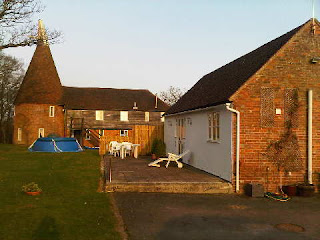
Waters Edge

This is our home for the next week - the building on the right. It's one of Forsham Oast's outbuildings, tastefully restored by the current owner.

Forsham was owned by Osbert de Forshamme in the days of King Edward 1, and Sir John de Forshamme held it, by old dateless deeds, in very early times.

The remains of an ancient chapel lie outside our front door. Beside the house is a pond with all manner of life, including Valerie and Trudi, Aylesbury ducks who will be providing us with tasty breakfasts.

Wednesday 28 March 2012 – The Lancashire Trail – Part 6 – Mellor to Whalley (Episode 2)

Norman demonstrates his plumbing skills at Whalley Weir

Time permits only a brief report on this walk just now.  Episode 1 will follow after Easter.

Towards the end of the walk, on another lovely summer’s day, Maude asked Norman, our resident ‘Plumber’, if he would be kind enough to demonstrate the skills of a ‘Master Plumber’.  When he had returned from his dunking, and Reg had dried him out, Norman looked at Maude with a puzzled expression.  “I said ‘Master Plumber’, not ‘Mad Plumber’” barked Maude “you stupid man!”

Back to Lancashire Trail Index

Thursday, 29 March 2012

Sunday 25 March 2012 – The 27th Two Crosses Circuit – An LDWA Production

Off route, on the summit of Bull Hill - a HuMP
From the 8am start in Tottington, it took us about 4 hours to reach Bull Hill, on the ‘short’ 18 mile route taken by this LDWA Challenge Walk.  Our little group from Timperley plus hangers on was nevertheless taking it easier than most, buoyed by JJ’s superior lethargy and jokes.  Here we are, Martin, John B, Judith, Alistair, Moira, JJ, Viv, Jeanette, Paul and Bailey, lined up by the trig point, all in aid of Alistair’s surreptitious ‘ticking’ of a HuMP!

Earlier, we had started bleary eyed after the clocks had gone forward by an hour, and my stomach had been less than compliant all night, so I for one was pleased to find some friends who were doing the short route, giving me a good excuse to abandon my planned long route (25 mile) challenge.

After a ‘mud dunk’ near the start, we passed the Pack Horse Inn at 9am.  Alistair posed by the doorway, already looking for 'refreshments' on this hot summery day.

Nearby, we took turns posing by Affetside Roman Cross - the first of the Two Crosses on this walk, this one situated on the ancient ‘Watling Street’ Roman Road from Manchester (Mannucium)to Ribchester.

By Affetside Roman Cross

Jumbles Reservoir was very calm, unlike Check Point 1 – where no refreshments were on offer, just the bizarre sight of a refreshing haircut on offer from a maniac masquerading as a 'Master Plumber'.

The Barber of Checkpoint Number 1

Beyond here, we encountered the splendid castellated railway bridge by Turton Tower, and a series of minor ascents as we gently perambulated along the Witton Weavers Way.

JJ cracked a few jokes in an effort to jolly everyone along to Check Point 4 – where there was no sign of any Master Plumber (thank goodness) but lots of tasty morsels.  We stayed for ages, watching loads of folk who had already done the extra seven miles of the long route speed through.

Amorous Canada Geese broke the glassy surface of the nearby Turton and Entwistle Reservoir, as we hastened on towards….

"Oh no!" exclaimed Alistair "we can't walk past this" ... "can we?", as The Strawberry Duck failed to secure our custom.  There has to be a first time for everything, I suppose.

We cracked on at a steady 5kph (3mph), slowing only when it got the better of JJ’s bowels.  JJ further slowed us to Moira and Judith’s more reasonable pace by stubbornly taking the lead, pretending he was the only one who knew the way.

Then Alistair and I decided to ‘bag’ Bull Hill, and were a little surprised when our entire group followed.  “It's a 'HuMP'” announced Alistair, after consulting his on-line Hill Bagging List - “a hill with a Hundred Metre Prominence”.  Alistair is a HuMP spotter.

We headed off the hill, JJ still in the lead.  But the diversion had thrown him.  We weren’t exactly going in the wrong direction, but we had missed a checkpoint.  So the marshalls at Check Point 6 were slightly surprised when 9 of their 300 or so customers suddenly appeared from behind their wall, ie from completely the ‘wrong’ direction.  We were disappointed to find that the marshalls had got so hot lugging up their barrels of water that they’d drunk it all.  They did however offer a well stocked bar – sherry, whisky, beer, etc, though I was still feeling queasy and others eschewed this fine facility.  Shame!

A little further on we arrived at the second of the Two Crosses on this walk - Pilgrim's Cross on Holcombe Moor.  Dating from ancient times, the cross was removed at some point in the mists of time, to be replaced in 1902 by the current structure, which makes a nice seat.  Here, David and Bill were enjoying a beer or two in the sunshine.  We debated whether alcoholics should be allowed on Challenge walks.  JJ asserted that ONLY alcoholics should be allowed…

David and Bill at Pilgrims Cross

Three ponies kept us company from here, all the way to Holcombe Brook, where one of their number spent ages splashing itself in order to cool down, much to the amusement of the riders.

Our next objective was Peel Tower, a monument to Sir Robert Peel constructed in 1852, where there were lots of refreshments on sale and the scene was much as it would be on a sunny summer’s day.

Peel Tower

We enjoyed good views north to Haslingden and Rawtenstall, but any effort to look south was greeted by a blinding sun and its associated haze.

By the time John B had slithered down a unique approach to Holcombe Brook, and we’d watched the antics of the horse in the brook, the others had disappeared.  So John and I plodded on to Check Point 7 – and, would you credit it, there was that Plumbing barber again...

“Where’s JJ"?” we asked.  “Where’s JJ?” reciprocated the barber.  Would you credit it, he’d missed another Check Point, and after a while appeared with his entourage from completely the wrong direction.  And he thought he knew the route like the back of his hand!

By now the end was in sight (figuratively speaking) and the sun was still shining as we passed Greenmount United Reform Church, before heading down a pleasant disused railway line and back to Tottington Youth Centre for tea and soup and lots of other refreshments for those without upset stomachs.

Here’s our '18 mile' route - 28km, 570m ascent – our version that took 6 hours 37 minutes.

Our route - 28km, 570 metres ascent, 6hrs 37mins

Thanks go to everyone at East Lancs LDWA for organising such a splendid walk, with excellent support (away from the maniac barber) and lots of good food.  The weather was pretty perfect as well.

There’s a short slideshow of my pictures here, and Alistair’s excellent blog entry is here.  The LDWA’s ‘Two Crosses’ page is here.

Saturday 24 March 2012 – Andrew’s ‘Appy Amble – A Peak District Wander

Starting off from the layby beside Ridgegate Reservoir

Andrew’s carefully crafted amble required a 10.00am departure from Ridgegate Reservoir, by Langley.  Some of us only just about got there in time.

On this occasion the ‘Famous Five’ (Sue, Jenny, Richard, Andrew, Martin) were joined by Liz and Neil, down from the Yorkshire Dales to taste some of the hillier bits of Cheshire.

Andrew led off past some forest, where the resident sparrowhawks weren’t in evidence today.  He seemed relieved when the usual tea van at Trentabank was conspicuous by its absence – that would have put us behind schedule!

Once on the open moorland above the edge of the forest, we could see a trail of people on their way up Shutlingsloe, a busy place on this warm sunny Saturday.

We soon reached the top and took our turn at the trig point.

On the summit of Shutlingsloe - Sue, Jenny, Liz and Martin

Elevenses on the summit were followed by the gentle descent towards Wildboarclough, from which we looked back to a hovering kestrel and the hordes on Shutlingsloe's summit.  Our path would now be quiet all the way to Tegg’s Nose, most people apparently preferring shorter excursions today.

Descending above Wildboarclough

A field of grazing goats provided respite from the ubiquitous sheep as we pottered on along Andrew’s carefully plotted route, which headed relentlessly north towards Torgate Farm.  Near the farm we stopped for lunch in the shelter of a wall (there was a miniscule cool breeze) with Shining Tor as our backdrop.

Lunch near Torgate Farm, with a Shining Tor backdrop

The afternoon’s perambulations soon had us up at Macclesfield Forest, where the schedule and the size of our group precluded a rest on the well positioned bench which relates the first two lines of William Henry Davies’s poem - ‘Leisure’.

Macclesfield Forest chapel

What is this life if, full of care,
We have no time to stand and stare.

No time to stand beneath the boughs
And stare as long as sheep or cows.

No time to see, when woods we pass,
Where squirrels hide their nuts in grass.

No time to see, in broad daylight,
Streams full of stars, like skies at night.

No time to turn at Beauty's glance,
And watch her feet, how they can dance.

No time to wait till her mouth can
Enrich that smile her eyes began.

A poor life this if, full of care,
We have no time to stand and stare.

Moving on from Macclesfield Forest - the place, we headed on up Charity Lane.  Some distressed mountain bikers saw us take to their preferred route, leaving the skittery pebbles for them to negotiate with care.  No animosity though, there’s room for everyone here.

Then we entered Macclesfield Forest - the forest, where on this particular path the trees always seem to look wonderful.  It’s a great forest path.

Macclesfield Forest

Through the forest and on below Five Ashes we strolled, behind schedule.  A short debate as to whether a short cut should be deployed was resolved by an overwhelming desire to visit the industrial archaeology of Tegg’s Nose quarries.  I’ve written about Tegg’s Nose before, notably here, so I’ll restrict today’s indulgence to just one of Sue’s photos.

Old quarry machinery at Tegg's Nose

Tegg’s Nose was even busier than Shutlingsloe.  Perhaps not surprising, given the cafe and toilet facilities.  There were lots of ‘Duke of Edinburgh’ students, clearly embarking on a summer of training to enjoy the Great Outdoors.  The weather won’t always be as kind to them as it was today…

We looked down from Tegg's Nose to the Reservoirs of Langley and to Croker Hill beyond – a hazy vista through which not even nearby Jodrell Bank could be discerned.

Passing through an area of brightly flowering Gorse, we noticed that it was full of ladybirds.

Bottoms Reservoir was flat calm apart from the ripples created by a pair of amorous Great Crested Grebes.  We had heard Chiffchaffs today – their arrival in the UK is a sign of spring, and blog postings from all around the country are recording their arrival.  I wonder where our Swifts are just now?

Bottoms Reservoir, Langley

Steam engines outside the Leather's Smithy distracted us briefly from a distance, or rather the raucous behaviour in the vicinity of the engines, as we completed this lovely stroll via the southern shore of Ridgegate Reservoir, before adjourning (not too far behind schedule) to tea and cake and an evening of fine dining at chez Andrew and Rosemary.  Thank you both for a splendid route and an entertaining evening.

Here’s our route - 20km, 650 metres ascent, taking a leisurely 6 hours.

Andrew's Amble - 20km, 650 metres ascent, 6 hours

There’s a slideshow here, and for those who prefer to walk a little further, there’s a report (courtesy of JJ) on a very similar but slightly longer route here.