Sue and Martin in Mallorca 2019

Sue and Martin in Mallorca 2019
On the Archduke's Path in Mallorca

Saturday, 12 May 2012

Friday 11 May 2012 - TGO Challenge Day 1 – Ardrishaig to Ford – A Fine Day in the West

Route: virtually as planned - see http://www.topwalks.com/tgoc2012.html Day 1 for map
Distance: 29.5km
Ascent: 600m approx
Time taken: 9hrs including at least 2.5 hrs stops
Weather: mainly cloudy with sunny periods and a cool north westerly breeze
Challengers encountered: most of the Ardrishaig starters, plus 'hangers on' Mildred and Barbara.
Flora and Fauna: lots of canalside flowers, including bluebells, greater stitchwort, pignut, lady's mantle, spurge, water avens, bugle, wood anemone, dog rose, lady's smock, primroses, forgetmenots, marsh marigold, red campion and lesser celandine. Later, common dog violet and lousewort on the hill.

Mergansers and mallards on the canal, eider and other ducks in the estuary. Long-tailed tits, goldfinches, siskin, greenfinch, great tit, chaffinches, buzzard, carrion crows, many wheatears, cuckoos, blackbirds, house martins, skylarks and meadow pipits.

Roe deer in Kilmartin Glen.

The Grey Gull treated us to a fine breakfast. This hostelry proved to be an excellent starting point with a great group of people. Thanks go to the Australian management and all their staff for making everyone so welcome.

We signed out and set off at 9am, with Sue in 'happy mode' because I'd arranged a flat walk along a canal towpath, as she had requested.

The Crinan Canal was opened in 1801 as a short cut (some say "the most beautiful shortcut in Britain") for lazy sailors who couldn't be bothered or were too scared to sail all the way around the dangerous waters of the Mull of Kintyre. Thomas Telford was involved a few years after that, when the original construction proved inadequate (ie - the canal collapsed). His attentions must have worked - today, mergansers were in charge of the placid waterway, some 200 years later.

We soon came upon the Cairnbaan Hotel, which suddenly and unexpectedly had to open its coffee shop. It was a very jolly group of Challengers who supped coffee and nibbled some remnants of shortbread, helped by the fact that many of us knew each other from previous trips. We even discovered that some of us have mutual friends, such as Gilly Hunt, who will be on our next trip - she lives down the road from Geoff Gafford, who was with us today together with Frank and Bert. Hello Gilly!

After this, most of the others were heading directly towards Carron Bothy, whilst Sue and I continued alone along the towpath towards Crinan. We saw no further Challengers today.

At Islandadd Bridge we headed away from the canal, into the Moine Mhòr, or Great Moss - a flat area that leads into Kilmartin Glen, an area rich with history. The glen has one of the most important concentration of Neolithic and Bronze Age remains in Scotland. There are more than 350 ancient monuments within a six mile radius of the village of Kilmartin, with 150 of them being prehistoric. Monuments include standing stones, a henge monument, numerous cists, and a "linear cemetery" comprising five burial cairns. Several of these, as well as many natural rocks, are decorated with cup and ring marks. The remains of the fortress of the Scots at Dunadd, a royal centre of Dal Riata, are located to the south of the glen, on the edge of the Great Moss.

Cup and ring marks or cup marks are a form of prehistoric art, consisting of a concave depression, no more than a few centimetres across, pecked into a rock surface and often surrounded by concentric circles also etched into the stone. Sometimes a linear channel called a gutter leads out from the middle. The decoration occurs as a petroglyph on natural boulders and outcrops and also as an element of megalithic art on purposely worked megaliths such as the slab cists of the Food Vessel culture, some stone circles, and passage graves. 

But I digress. We paused at length at the 5000 year old Temple Wood stone circle (pictured above), and spent a while exploring the interior of a burial mound. Luckily for Andrew W, his route doesn't pass this way....

En route, the sad remains of Poltalloch were past. The sad tale of the rise and fall of the Malcolm family's fortunes is reflected in the crumbling masonry of this once stately building. The nearby church, however, remains intact and is worth a visit - it sports some lovely stained glass windows and Malcolm memorabilia.

Hastening on to Kilmartin, we joined David and Janet in their lovely new garden. They moved here on Wednesday, so we provided our last two pieces of shortbread by way of a house warming present. Jim joined the party and was placed on wardrobe carrying duty. Thanks for the tea + biscuits, you two.

Alan Hardy had predicted a boggy ascent of Beinn Bahn, but it really wasn't bad, with the reward of a summit 'brew stop' out of the wind with great views back over Kilmartin Glen to the Paps of Jura, and on to Loch Awe, most scenically placed in the evening sun, with the snow-capped summits of Ben Cruachan glittering behind the loch.

Then we strolled pleasantly down to Ford, where Alison J soon whisked us back to Kilmartin Hotel for a good meal, and a most enjoyable evening. I've known Alison for 40 years or so and hadn't seen her for a while, so it was great to catch up. She sends her best wishes to those mutual friends who read these pages, as do David and Janet.

Alistair, Lyn, Martin R and Alan R - thanks for your comments. We noted how well Lynsey was looking in Glasgow, Alistair - we hope she has a great crossing.

That's all for now, apart from thanking Alison for her excellent B+B service - more than enough, I suspect, though given a lack of 'phone signal you may not receive it for a while.

Sent using BlackBerry® from Orange

Thursday, 10 May 2012

Thursday 10 May 2012 - TGO Challenge Day 0 - Montrose to Ardrishaig - A Rainy Day 'Up North'

After a sunny six hour drive to Montrose, with spring foliage and rape looking splendid in the bright light, we soon got into the 'Challenge Spirit' by way of a ritual encounter with three generations of the Fowkes family outside the fish 'n chip shop. Bernard, Margaret, Jackie and Emily, together with Emily's friend Lee, were all looking as chipper as ever. Bernard is nearing his 84th birthday. "This will be my last Challenge" he muttered, like a broken record.

Then JJ's valuables were dropped off at the Park Hotel, where the staff are, as always, looking forward to TGO Challenge fortnight, before we adjourned to spend a very pleasant evening with Alison R, who sends her best wishes to any readers who may know her. She was on excellent form.

Today Alison kindly gave us a lift to the station as it was, and many hours later still is, raining. It has been a thoroughly wet day, but a very jolly one. Seating on the train to Glasgow was a bit haphazard due to a freight train derailment, but the train was on time and the only mishap involved one of the heavier Fowkes rucksacks making an unexpected bid for freedom from the luggage rack, attacking three of us as it tried to escape from the clutches of its owner. Perhaps it knows what it's in for over the next two weeks!

Sue counted about sixty Challengers at Queen Street, plus a number of 'supporters', most of whom were provided with shortbread or brownies* to help them on their way.

It was great to renew many acquaintances here, but sad not to see Tim and Kate Wood, who have had to drop out due to Kate's illness. I'm sure we weren't the only ones to miss them. Our thoughts are with you, Tim and Kate.

After waving off most of the others on the 12.21 to Oban and Mallaig (including JJ, who appeared - dripping with anxiety - with about two minutes to spare), a short dash to Buchanan Street, via some last minute purchases at Tiso's and lunch in John Lewis's, found us with a select group, including our old friend Roger Boston, on Citylink's 2pm service to Campbelltown. It was another pleasant journey, despite the rain, on a posh bus.

Roger is pictured above, with various others whom I'll leave readers to try to identify, leaving the bus when we reached Ardrishaig at 4.45pm. Can you tell, I was struggling to get a picture for today - I should have taken one at Queen Street.

A dash up the wet street soon drew us to the welcome of the Grey Gull Hotel, where Sue and I have been treated to a huge family room in which to sort out our vast selection of gear for tomorrow's walk, which I've told Sue will be mainly flat and may feature a house warming party, for which she will of course be expected to provide the shortbread.

*I'm a proud man tonight after Jackie F offered me a position as 'brownie cook' at her high class café in Melbourne, Derby!

Wednesday, 9 May 2012

Paul Brunn – 1950 to 27 April 2012

Paul Brunn - May 1970

It was with great sadness that I attended Paul’s funeral today.

Paul was a contemporary of mine at UMIST over forty years ago, and is pictured above showing his usual responsible style of management, in this instance in May 1970 as newly elected Chairman of the Tech Domski Hiking and Hostelling Club (TDHHC), by attempting to ride a children’s pink elephant outside an amusement arcade in Whitby.

Whilst family life and work commitments as a Mechanical Engineer drew Paul, like many of my other TDHHC contemporaries, away from a life in the outdoors, we had kept in touch over the years by way of occasional meals etc with others who were thrown together in the lottery of lifelong friendships that one tends to establish with contemporaries from University days.

My abiding memory of Paul is his expert and captivating rendition of ‘Napoleon’s Retreat from Wigan’ at the Fish Inn in Buttermere, before he adjourned to lie on his tent in the rain in a nearby field of cows.

There are many more happy memories – but time is against me today.

Paul was a lovely person and a great personality who will be sadly missed.  Our condolences go to all his family and to his friends.

The TGO Challenge 2012

Poor Michael struggles to find a way down to Glen Feshie on 20 May 2011
It’s that time of year again.  Doesn’t it come around quickly?

Tomorrow (well, later today actually, but after a sleep), Sue and I embark on a journey to Ardrishaig, at the southern end of the Crinan Canal, for a 250 mile ‘pilgrimage’ across Scotland, starting on Friday 11 May and finishing at Nigg Bay, Aberdeen, on Thursday 24 May.

We are hoping for sunshine like that in the above picture taken on ‘The Challenge’ on 20 May last year.  In this picture ‘Poor Michael’ is bathed in sunshine as he battles against gale force winds in a bid to free himself from the clutches of Carn Dearg Mor and descend to the relative calm of Glen Feshie.  An icy squall was about to hit us.  So, we’d like some of that sunshine, but perhaps not so much of the wind and rain, though it IS supposed to be a Challenge, and last year’s weather really wasn’t all that bad.

I’ll be trying to post diary entries as we make progress, but I won’t be putting up daily route maps.  Instead, they are all on this web page, together with a sort of kit list and some statistics.  I’ll link daily to that page, and you can click on the Day Number to go straight to the relevant map (should you so wish).

Before setting off to deposit our transport in Montrose (JJ has ordered a taxi to Timperley on 25 May – transport has to be in position) we’d like to wish all other Challengers a happy and safe crossing, or – if they aren’t doing it this year, an enjoyable vicarious experience (as for all other readers).  We look forward to bumping into a few old friends, and making some new ones, and Sue will of course be trying hard to cement her reputation as ‘The Shortbread Lady’.

Let the journey begin (subject to one unhappy matter that will be obvious from the next posting).

Tuesday, 8 May 2012

Sunday 6 May 2012 – Tales from a Towpath

On the towpath at Middlewich

So, the day finally had to arrive…

“Time for some TGO Challenge training” declared Sue, suddenly becoming aware of the imminence of our forthcoming 250 mile walk across Scotland.

“Let’s take a leaf out of the Fenlanders’ book”, I suggested.  “Some of them have managed to do it quite a few times, and I think the secret of their success lies with their training regime.  That means the training must take place somewhere flat, and beer and food need to be involved.”

We duly selected Middlewich, in the flattish plains of Cheshire, as a suitable venue.  It’s not far away from home, and the short drive soon found Sue and me admiring the anciency of Halfpenny Hill, as this spot was apparently known until 1309.

Middlewich Church

“Halfpenny Hill!” Sue exclaimed.  “You told me it would be flat.”

My solution was to guide her down to the towpath of the Trent & Mersey Canal.  “It doesn’t get much flatter than this” I suggested.

“What if I fall down a hole?” she jested.

Anyway the day was ideal for a stroll along the grassy towpath.  We noted some lovely old signs along this 92 mile stretch of waterway. They date from different periods – the first we passed was dated 1813, the next one, very similar in design, was from 1977, perhaps a replacement when the waterway was refurbished.

The canalside forget-me-nots were a vibrant blue on this sunny day.

Canalside forgetmenots

Posh new signposts eliminate the need for the mental stress of metric conversions for the good people of Middlewich.

Middlewich - home of posh new signposts

The stroll north along the towpath was exceedingly pleasant.

Beside the Trent & Mersey Canal north of Middlewich

"Hello!" exclaimed Gerry, as we chanced upon what could only be described as a Motley Crew.

Who are these people?

By now, Sue was feeling quite tired from the 4 km she had managed to cover, so she blagged a lift back to Middlewich.  I felt obliged to stow away with her.

We passed quite close to this heron....

A nonchalant heron

Lovely reflections were admired as we glided along, though the water was a little on the brown side due to lots of barge propellers churning up the mud.

We had arrived just in time for 'elevenses'.  Sue’s voracious appetite had perhaps been anticipated?

Elevenses

A short queue was encountered at Middlewich's 'Big Lock', and with Robert being assisted by Roger, the boat was always going to look a little 'misdirected'.

Roger assists Robert

...but it slowly wandered into the Big Lock.

In the 'Big Lock'

It was a slick operation. Everyone had a role, especially Stewart…

We were impressed by this pristine bench in Middlewich.

A Middlewich bench

Louise took on the role of 'Water Diviner' - it seems the boat required regular drinks of ballast to prevent it rising up and flying away.

”Look what a mess you’ve got us into now, Robert!”  Louise was angry.  “It’s all that ballast you put in” retorted Robert, “it’s made us go down.  I think we’re trapped!”

"Where do we go from here?"

Eventually, Gerry found a gadget that would release the boat from its trap, albeit she slipped a disc in her desperate attempt to ‘un-lock’ her friends.

Gerry slips a disc

It was indeed a Motley Crew that was trying to manoeuvre the good ship Phoebe through this set of locks at Middlewich.

After a while Robert guided the old boat gently into the bank, and Phoebe took a break for a while.

You may recall that ‘food and beer’ were a prerequisite of this training walk.  I’d been a little apprehensive as I’d forgotten to bring either of the said items, but luckily this bunch of naval cadets had their priorities quite well sussed.  Lunch was quite a lavish affair…

A pauper's lunch

After lunch, at last, Robert got the boat straight, pointing it neatly towards the bridge ahead. "But our route is under the bridge to the right" shrieked Lyn, having finally managed to locate our position on the map.

The turn down the Middlewich branch of the Shropshire Union Canal took us under a rather low bridge and through a series of challenges that readers will have to visit the slideshow to discover.

Eventually, clear water was reached.  "Hey up there...where are we?"

All that's missing is the white stick!

"I'm down here, having a shower" came a weak voice from the business end of the ship, which seemed to have entered another culvert.

Roger takes a shower

This branch of the Shropshire Union Canal comprises a lovely rural section of waterway.  Our passage caused havoc with a family of ducks - mum and 12 chicks.

Soon, with Stewart at the helm, Robert knew the safest course of action for the safety of the whole crew.  He abandoned ship…

...so did Roger, who had nearly drowned in his bid to escape when Stewart grabbed the tiller.

Phoebe - a survivor of much abuse

“We are getting a long way from Middlewich” moaned Sue “I want to go home.”  So we did.

Here’s today’s  training ground.  We walked from Middlewich to somewhere near Bostock Green, then after cadging the lift, we walked back from half way between Middlewich and Clive Green.  About 6 km in total.  “Excellent preparation” Sue agreed, adding “I trust you’ve planned a TGO Challenge route beside a canal, and no more than 6 km a day…”

Oops!  I’m half way there – that’ll have to do.

0600route

Our sincere thanks go to the entire crew of Phoebe for putting up with us for so long!  And for catering for Sue’s voracious appetite. 

There’s a slideshow (53 images) here.

Robert’s alternative (fictional?) account of the entire trip can be found here.

Monday, 7 May 2012

Friday 4 May 2012 – An Evening in Deepest Cheshire

Whipping Stocks Inn sign

The first of Andrew’s ‘Deepest Cheshire’ evening walks of the year took place on a fine if overcast evening, starting with a taste of ale at the Whipping Stocks Inn.

Mary, who is usually found on Tyneside, joined us for the evening, and we set of at a gentle stroll along a pleasant path through Ambrose Acre, heading towards the country pile that is Peover Hall.

Strolling through Ambrose Acre

Round the corner from the hall is St Lawrence’s Church. The original church was built in the reign of Edward III (1327-1377). The present tower was built of brick in 1739, and the nave and chancel were rebuilt in brick in 1811.

Over Peover Church (St Lawrence's)

The words on this gravestone will be familiar to connoisseurs of such places.

Gravestone in St Lawrence's Churchyard

Here’s the hall, a private house with one car outside…

Peover Hall

The stables date from 1654 according to this lintel.

Lintel over stable door

It’s a large building – the lintel is just above Mary’s head.

Peover Hall Stables

Further on, past an abandoned golf course that has been allowed to return to grazing land, Colshaw Hall’s entrance sports a nicely varnished sculpture produced from the stump of a felled tree.

Sculpture by Colshaw Hall

The area is littered with expensively refurbished /rebuilt farmhouses, and we passed four vast swathes of lawn each sporting the double posts that Andrew recognised as being the goalposts of polo pitches.

Here’s just one of those pitches.

Polo field in Peover Superior

“How the other half live…” we chorused.

Beyond the opulent displays of obscene wealth, farmers were still working in the fields as dusk came and went, and we returned to the pub past another huge building that used to be a private house, Radbroke Hall, now home to some of Barclays Bank’s offices.

Here’s the route of our 9km amble through pleasant Cheshire countryside.  A pleasant and genial two hour stroll tonight.  Thanks go to Andrew for planning the route.

Our route - 9km, 24 metres ascent, 2 hours

Friday, 4 May 2012

Nelson Peach – Jack Frightenem Goes Viral?

Nelson Peach - Jack Frightenem

Sue and I were privileged last night to attend the launch of Cult Folk Band, Nelson Peach’s latest CD launch.

It was an excellent evening, very well attended, with lots of chocolate pudding Jennings Cumberland Ale.

Well done, Richard, Lesley and Rick, pictured below, from a distance, with a very weak flash, from a drowned camera.

Nelson Peach at their Jack Frightenem CD launch on 3 May 2012

I understand there has been a ‘run’ on stock of this fine CD, so readers should order now from the foot of this page to avoid disappointment.

Thursday, 3 May 2012

Who ate all the Chocolate Pudding?

Backpackers in the Egerton Arms

I’ll give you one guess.

“Just bulking up for the TGO Challenge” quipped the culprit.  Fair enough, I suppose, he/she had walked 50 miles on Saturday “to loosen up for The Challenge”.  A first-timer whose spoon had failed to reach stared longingly at the well-licked plates.  Another, a seasoned Challenger who isn’t doing it this year (Fort William to Edinburgh has preference) looked on, with a knowing grin.

Such was the excitement to be gained from last night’s bi-monthly ‘Backpackers Meal’ – this time at the Egerton Arms, Astbury, whose restaurant behaved very understandingly on the night, as our meal time was delayed when a '”we’ll be there in five minutes” message turned into a half hour delay.  There is more than one Egerton Arms in Cheshire….

The loudest laughs of the night were however reserved for a Challenger who was absent, but who has recently published a kit list with a glaring missing item.  Personally, I think he deliberately missed off the vital piece of equipment just to wind the rest of us up.

Wednesday, 2 May 2012

Curious Brothers

The Curious Brothers - two ibex in the Maritime Alps

I entered this image of two young ibex in the Austrian Alpine Club Photo Competition (2011).  It didn’t win anything.

However, it’s more interesting than the pictures from Timperley this week, where I’ve been ensconced at home whilst our garden fence has been most effectively replaced by Ian, Mickey and Jay, from CL Fencing Services.  At least that gave me a chance to print our maps for next week’s TGO Challenge and order a few consumables from Bob and Rose, Webtogs, and others.  Annoyingly, the closure of Milletts in Altrincham leaves us with no local outdoors shop, so I’ll have to go into Manchester to buy new boot laces and proofer.

There still seems lots of ‘House Admin’ to do before we set off this time next week to start The Challenge, but I’ll try to make one or two postings in the meantime before the routine of daily ‘mobile blogging’ takes over.

Saturday, 28 April 2012

Tuesday 24 April 2012 – An Evening Stroll on the Sandstone Trail

Sundown on Snidley Moor

The venue for tonight’s evening walk was Beacon Hill, near the start of the Sandstone Trail.  I had thought I might be alone, but Sue made time to come along, as did Richard and Andrew.

We enjoyed a delightful evening, pausing on Woodhouse Hill to admire the views across to Liverpool and The Wirral, not to mention the Welsh mountains.

Admiring the view from Woodhouse Hill

In days past this high ground was favoured by early settlers because the heavy clay soils of the plain gave rise to a landscape of thick woods and poorly drained mosses (think of parts of modern-day Delamere Forest).  The hills were drier and had light, sandy soils which were easier to work and not so densely wooded.  Lines of communication during this period may also have followed the sandstone ridges, on which there is plenty of evidence of ancient (circa first century BC) hill forts, built in the years before the Roman occupation.

On Woodhouse Hill

The sandstone hills themselves were shaped by ice sheets during the last ice age, between 75,000 and 10,000 tears ago.  Until well beyond the Middle Ages, tidal marshes and reedbeds reached far inland.  But the building of the Manchester Ship Canal around 1894 brought major changes.  The ‘Big Ditch’ as it was known, cut off the marshland from the sea, releasing much of the wildlife rich wilderness for farming and industrial use, as you may surmise from the poor sunset picture below (taken with the ‘drowned’ Ixus 105 camera on its fourth temporary resurrection – Richard’s iPhone images should be much better).

Sunset from Woodhouse Hill

After a while it got quite dark, so our visually challenged member resorted to torchlight, but the ambient light was sufficient for the rest of us to safely regain the Simon’s Lane car park (SJ 518 766) before adjourning to the Bull’s Head to admire the thrashing of Barcelona by the most unlikely of opponents (Chelsea, for the record) and enjoy a blather with a beer.

This 10 km (6 mile) route is an excellent introduction to the 34 mile Sandstone Trail.  Allow 2 to 3 hours.  A shorter version is described here.

Our route - 10km, 250m ascent, about 2.5 hours

Postscript:

Conrad took one look at the sunset image and thought he could improve it in Photoshop.  I’d already improved it from this original:

Sunset from Beacon Hill

But Conrad did even better:

Sunset from Beacon Hill

The escarpment is Helsby Hill.

Friday, 27 April 2012

Scotland – Monday 16 to Sunday 22 April 2012

Jutta, Robert and Wolfgang with The Quiraing behind them

Monday 16 April

I reported on a sunny drive to Skye here.  This posting summarises ‘Monday to Friday’ and gives a little more about the weekend.  If you prefer just to look at the pictures, they are here.

My sunny drive was punctuated by many pauses, notably at Loch Laggan, at the War Memorial near Spean Bridge, with views of Ben Nevis clear of cloud, and by Loch Loyne, to admire the mouthwatering western summits beyond the loch.

From Loch Duich there was a good view to the distinctive slopes of A' Ghlas-bheinn in the background, with the slopes of Beinn Fhada to its right.

A' Ghlas-bheinn and Beinn Fhada from Loch Duich

Soon afterwards the Skye bridge and the Cuillin hills beckoned enticingly, and Seaview Guest House in Broadford was a welcoming venue for a reunion with Wolfie and Jutta, who with their friend (and my room mate) Robert made up this year’s complement of the ‘Dornbirn Crew’.

Skye beckons the traveller

The trio had just finished a B&B trip along part of the Skye Trail, and we enjoyed a pleasant evening and a satisfactorily spicy meal in Kyleakin’s ‘Indian’ (actually Bangladeshi) restaurant.

Tuesday 17 April

We wisely scrapped a plan to slog up Glamaig in the rain, in favour of a trip to The Quiraing which the others had not previously visited. My report on that day is here and as always there are lots more pictures in the slide show here. By way of a flavour, here’s Jutta after ascending through The Prison gully.

Jutta ascends through The Prison

We (except Robert who declined to ascend due to his vertigo) enjoyed lunch on The Table, and we regrouped in good weather for a jaunt up to the easy summit of Bioda Buidhe, and some really excellent views.

Here’s our route - 10km, 650m ascent, taking around 4.5 hours including breaks.

Monday's route - 10km, 650m ascent, 4.5 hours

Dinner was taken at Coruisk House in Elgol.  Good food in an interesting place, and I have to thank Markus, Wolfgang’s brother, for paying my bill (all the way from Dornbirn!).  I have some very generous friends.

Wednesday 18 April

Leaving the ‘Dornbirn Crew’ to make their way home, I enjoyed another sunny drive, this time to Arnisdale.  Frequent photo pauses - Loch Duich, Kintail Lodge Hotel, another view of A' Ghlas-bheinn, this time from Mam Ratagan, Beinn Sgritheall’s snowy northern slopes, resulted in a very slow journey.

My contemporaneous report on the day is here.

The stalkers path up to above the Eas na Cuingid cascade is very easy, and beyond that, even though the route abandons the path, the ascent of Beinn nan Caorach is really very straightforward.  I suspect that Alistair P plans to go up Beinn na h-Eaglaise before Beinn nan Caorach on next year’s TGO Challenge – that would be a brutally steep, if easy, ascent from Arnisdale, or a scrambly ascent from Bealach Arnasdail if he chooses that route.  I may be in the same area!

Beinn nan Caorach, sports great views of Beinn na h-Eaglaise with Beinn Sgritheall behind, and Ladhar Bheinn can be seen in its full glory standing impressively behind Loch Hourn.

From Beinn na h-Eaglaise, Rum is clearly seen, but all bar the southern tip of the Cuillins are hiding behind the bulk of neighbouring Beinn Sgritheall.

On the steep descent from Beinn na h-Eaglaise after easily gaining the small lochan at Beinn Bhuidhe, lousewort was flowering, and on the lower slopes spring was coming along fine, the call of the cuckoo being accompanied by the sight of primroses, dog violets, lesser celandine, cuckoo flower, gorse, and more.

These docile highland cattle squinted at me as I passed, but the nearby herd of deer (see slide show) was a little more jittery.

Highland cattle in Glen Arnisdale

This most enjoyable outing, finishing just as some rain came in, was followed by a scenic drive to Newtonmore, and a welcome from Sue and Neil at Newtonmore Hostel.

Here’s today’s approximate route - 15km, 1000m ascent, taking 5 hours including breaks.

Tuesday's route - 15km, 1000m ascent, 5 hours

Thursday 19 April

Today’s contemporaneous report is here.

Basically, I enjoyed a walk from Kingussie with Sue and one of her three lurchers, Harvey.  The sun came out as we strolled up Glen Gynack  but by the time we reached a lunch hut we were glad of the shelter.

After winding through the mist from Beinn Bhreac, we were pleased to reach the summit of Carn an Fhreiceadain (878m) – this would be a very easy tracked route in good weather with no snow cover, but the swerving track did nearly fool us at one point.  We passed a strangely large cairn on the way down and even met three old fogeys ascending this easy Corbett, a rare encounter by the week’s standards.

Here are Sue and Harvey, eying up a spot for lunch by Allt Mor.

Sue O and Harvey scout for a lunch spot beside Allt Mor

Here’s today’s approximate route - 19km, 670m ascent, taking about 5 hours including breaks.

Wednesday's route - 19km, 670m ascent, 5 hours

I spent a second evening in the Glen Hotel, after brewing up a sumptuous pasta on the hostel stove, this time with a JOGLE cyclist, Sam, who helped me fail to assist a family from Birmingham in their quest to win the Pub Quiz.

Friday 20 April

The further west I went, the fouler the weather became.  I nearly abandoned walking today, but after lunch in the car at the Linn of Dee I decided to give it a go, if only to stroll up to White Bridge and back.

As it was, the rain stopped as I strolled alongside the River Dee, observed by the first wheatears I’d seen this year.  Beyond White Bridge water was rushing down the Chest of Dee’s rapids.

Chest of Dee rapids

Sgor Mor’s 813 metre summit was gained after a bit of a thrutch through deep heather, but the 3km ridge walk to Sgor Dubh’s 741 metre summit was a delight, though the higher Cairngorm peaks were sadly enveloped in cloud.

It actually turned into a sunny afternoon in the Dee valley after a steep final descent through deep heather, before I pootled back to Craiglea B&B in Braemar to write up my report on the day before being joined by The Workers – Sue, Lyn and Alastair.

Here’s my route for the afternoon - 17km, 500m ascent, taking 4.25 hours including breaks.
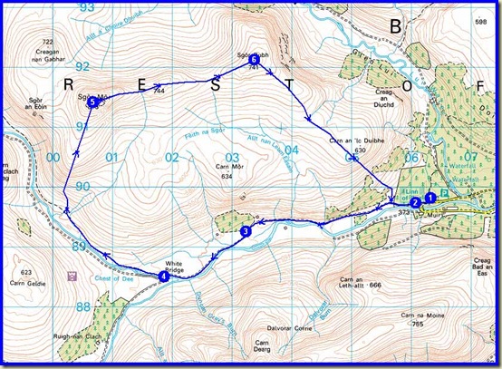
Thursday's route - 17km, 500m ascent, 4.25 hours

Saturday 21 April

Fortified by an excellent meal at Moorfield House Hotel, and by Dave and Angela’s fine breakfast, we felt able to tackle something hilly despite rather iffy weather.  Al’s original plan for a long day up Beinn Bhreac and Beinn a’ Chaorainn was discarded in favour of an easier route over An Socach, taking advantage of the luxury of having two cars at our disposal.

Sue chatted to the horses at Baddoch whilst the rest of us faffed with our equipment, before we set off at a cracking pace up the glen beside Baddoch Burn for about 6km.  Well, the others set a cracking pace; I was in ‘holiday mode’.

After catching them up when they stopped for elevenses, I watched them disappear into a cloud ahead as we ascended the fairly benign slopes of An Socach.  At least, they seemed benign to me so long as you kept to the left of a snow filled gully.  The others had apparently waited there, in a cloud, for me to turn up, so the 944 metre summit was deserted when I reached it.

I always knew they would turn up, as Al and Lyn had not been here before and Al needed to tick it off us ‘bagging’ list.

We were in and out of cloud as we descended to the north, but the long valley that is Glen Ey soon appeared for good.

Looking down to Glen Ey from An Socach

A steepish descent, during which Sue tried to wreck her overtrousers by bum-sliding over heather, took us to a delightful lunch spot, after which we continued into the long valley along deer trods, eventually crossing the Ey Burn cascade at the ruins of Altanour Lodge, from where an excellent track runs all the way, over 8km, to Inverey.

Four cyclists on hire bikes passed us, presumably having bagged the Munros - Carn Bhac and Beinn Iutharn Mhor.

Half way down Glen Ey, Sue spotted a big bird.  It was great to watch the golden eagle soaring for some time close above the slopes of Creag an Lochain before landing in a tree.  Oyster Catchers also accompanied us today, together with dippers, curlews, golden plovers, some ducks, and several smaller unidentified birds.

A couple of bridges over the Ey Burn later, and “we must be getting close to Inverey, mustn’t we?” by which time the sun had emerged.

On our way back to Craiglea B&B (Dave and Angela) we called in at Thornbank to visit Simon and Kat, who fed us with delicious žemlovka.

Visitors to Braemar may enjoy a visit to Thornbank, where Kat can apparently provide miraculous therapies for certain ailments – see here.  Sadly she won’t be in town during the imminent TGO Challenge, and Sue will be too busy cooking my tea to offer services in the ‘therapy room’!

Here’s our route for the day - 21km, 550m ascent, taking 6 hours including breaks.

Saturday's route - 21km, 550m ascent, 6 hours

The Moorfield provided more excellent nosh.  But we were the only customers, not that anyone seemed to mind or even look worried.

Sunday 22 April

Simon joined us on this last outing of the trip. After dumping some cars at the Spittal of Glenshee, we returned up the pass for an easy 35 minute stroll to reach our first Munro of the day, Carn Aosda.

Group on Carn Aosda (917m)

45 minutes later, on a pleasant but overcast day, we'd reached the ugly summit of The Cairnwell (933m), our second Munro of the day.

Returning to an old sign, we took the ridge to the south of Loch Vrotachan.

It's quite a broad ridge - no dangers here - with Carn nan Sac  a fairly short walk away, providing a mid point on the walk to our final Munro summit of the day.

There’s a good view to the south east from Carn nan Sac, beyond a prominent cairn, across to Creag Leacach, the other side of the A93 road.

There was snow lying above 850 metres or so, but although it was very soft it wasn't deep enough to hinder our progress.

A little over an hour after leaving The Cairnwell, our third and final Munro of the day was reached - Carn a' Gheoidh (975m).
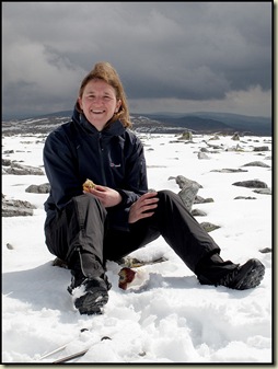
Lyn on Carn a' GheoidhAl on Carn a' Gheoidh

After a short break on the summit, we headed to a more sheltered spot for lunch - not that it was very windy – after admiring the view south, with Carn Mor and Ben Gulabin ahead.

The steep snow was too soft for glissading, but we soon reached the subsidiary summit, Carn Mor, where Lyn seemed to spend the whole time peeling off her overtrousers whilst the rest of us enjoyed our lunch.

We enjoyed the views towards Glas Tulaichean for the rest of our walk.

Glas Tulaichean from Carn Mor

A large group of ramblers approached from the south as we ambled off Carn Mor.  “We are the Dunperthing Rambling Club” announced their spokesman, “today we are going up Carn Mor.  Is it far to the top?” adding, under his breath:  “Which club are you in?  You don’t seem to have many members.”  I explained that we were a group of private individuals and that we had ‘permission’, and left it at that.

As Ben Gulabin got closer, a wide and brutal ascent path was revealed – it turned out to be as steep as the ascent up into The Prison in the Quiraing.  Thankfully it was almost as short and a little while later we were enjoying a siesta on our final summit of the trip - Ben Gulabin (806m) - on a warm April afternoon.

In the sun on Ben Gulabin (806m)

Having admired the views at length, we then headed off home, and as customary during the course of this week, the sunshine heralded a shower, so we just failed to reach the cars left at the Spittal of Glenshee before the rain came ...

Never mind, our clothes are all dry now!  I think.

Here’s the day’s route - 18km, 800m ascent, in a shade under 6 hours including breaks. (Three very easy Munros and a Corbett.)

Sunday's route - 18km, 800m ascent, 5.75 hours

There’s a fairly lengthy slide show here, if you can stomach it.

Phew!  I’ve had this posting hanging over me all week.  Time to move on…