Sue and Martin in Mallorca 2019

Sue and Martin in Mallorca 2019
On the Archduke's Path in Mallorca

Saturday, 16 June 2012

Saturday 16 June 2012 - Maol Chean-dearg

After last night's party, those still standing chose a relatively easy hill for today's walking exploits.

Thus it was that after waving goodbye to Steve, Jenny and Richard, who were heading off today, ten of us drove through light rain to Coulags, where it wasn't raining.

The path up to Bealach a' Choire Ghairbh, past a rather smart bothy, is a delight, from near sea level to around 600 metres without really noticing the gradient.

From the bealach the path steepens to reach the Munro summit of Maol Chean-dearg (933 metres) rather more easily than the slabby route up the neighbouring Corbett - An Ruadh-stac (892 metres). Both are fine hills, but today their summits were only intermittently revealed through the cloud. Our summit photo was, for the first time for a while, without a view, although it was warm and calm enough to enjoy our lunch around the massive summit cairn, which for many of us featured large slabs of Louise's alcoholic chocolate cake.

A pair of ptarmigan were on hand to inspect the site and join the mice in a hunt for Sue's dropped crisps.

An uneventful descent concluded our travails in this part of the world for the time being, though others in our group are continuing to other parts of Scotland in an ongoing hill climbing frenzy.

Today's 17km included about 900 metres ascent and took around 6.5 hours.

As soon as we set off from Coulags the rain started again. Sue thinks she saw an otter swimming in Loch a' Chroisg. Julie had been on a short walk slightly to the east of us; it had rained all day there. The ten of us had been very lucky.

We've also been very lucky to have Louise and Liz as our catering department. They have fed us like the Lords and Ladies who are their usual clientele, finishing tonight with Mull scallops, haggis-neeps-n-tatties, apple crumble, and the usual fine cheese board.

I'm out of time now, so you are spared more fauna, flora and geological etc stuff - until next time! We travel home tomorrow, and some 're-grouping' will be required before the next trip.

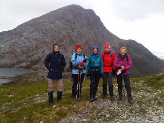
Today's photos were both taken near Bealach a' Choire Ghairbh, the first showing Meall nan Ceapairean, which I'd planned to climb but didn't, with the second picture of today's girlie contingent (Sue W, Tove, Sue B, Ruth and Carol) in front of An Ruadh-stac.

Sent using BlackBerry® from Orange

Friday, 15 June 2012

Kinlochewe Lodge

This week's venue, situated amongst some of the finest hills in Scotland, is an early C20 hunting lodge currently owned by Pat Wilson, a Perth landowner. It's rented out on a weekly basis to groups like ours, with the Wilson family using it for just 2-3 weeks a year.

The occasion, as mentioned earlier, is G+T's 100th birthday party, celebrating their passage of fifty years each.

It's a great place to stay, and quite reasonably priced if the cost is divided between 18 people plus 'staff'. There are lots of rooms. Cluedo style jokes abound - was the murderer Miss Brown in the Billiard Room with the Ice Axe, or was she in the Music Room when the gory deed took place?

I know of other groups who have used the Lodge on a self catering basis, but we have Louise and Liz, thus freeing the rest of us from any worries about where our next meal is coming from.

Although the Lodge is close to the centre of the village, we are told that pine martens can often be seen serenading on the lawns at dusk. It would be a treat to see one of these elusive animals, but we haven't seen one yet.

The Lodge is altogether a brilliant base for a trip of this nature.

Sent using BlackBerry® from Orange

Friday 15 June 2012 - Fionn Bheinn

With high cloud and a bit of a breeze drifting in with a gradual change in the weather, we chose an easy day on a Munro that Sue hadn't previously visited.

Taking a direct route from Achnasheen, beside Allt Achadh na Sine, we soon reached a pleasant spot (pictured, with Meall a' Chaorainn behind) for a cup of tea or two.

I thought the ascent would be harder, but despite an increase in the wind velocity and the absence of a clear path, the summit trig point dutifully appeared a couple of hours and 800 metres ascent after our 9.30 start.

We were just below the cloud base, in a strong breeze against which Sue braced herself for a summit photo (see lower image). Two other walkers were also enjoying a day out; otherwise we saw nobody on the walk.

It wasn't a day to linger, but the easy path down Sail an Tuim Bhain enabled us to enjoy the wide ranging views. To our south, cloud had enveloped the summits, whilst to the north everything was cloud free - including An Teallach on the horizon. So the rest of our group would have good views as they 'toured', visited gardens, or ascended a nearby hillock.

We reached the road after passing through a sequence of deer fences, with the inevitable roe deer being trapped in the forest that the fences are supposed to protect. Here we bumped into the gents we'd seen on the summit; it would have been impolite of us to refuse the lift offered back to our car.

The 11km walk, with about 800 metres ascent, had taken just 3.5 hours - leaving plenty of time for lunch at the roadside viewpoint that overlooks Kinlochewe, and a long chat with Louise before anyone else arrived back at the Lodge.

Today is GI's 50th birthday, which together with Tove's achievement in reaching the same vintage earlier in the year is the reason we are all here this week.

Happy Birthday, Graham and Tove (who don't read these pages, but I'll refrain from insulting them on this occasion).

So there will be a big party tonight ...

Sent using BlackBerry® from Orange

Thursday 14 June 2012 - Beinn Alligin

Beinn Alligin is one of my favourite hills, so it was great to be up there again today.

Unlike Monday, when both hills had several summits of similar height to visit to ensure that the tops had actually been 'bagged', Beinn Alligin sports two indisputable summits - one at each end of its easy summit ridge. The difficulties, such as they are, on Alligin involve the traverse of its three 'horns' which grace the north eastern spur of the hill. Today we chose to visit these in ascent, which perversely involves an awkward if well protected descent move on the way down from the final horn before scrambling easily up to the Munro summit of Sgurr Mòr.

Sue and I had set off with Steve, who would spend the whole day with us, and with Graham, Richard and Jenny, who chose the excellent traverse of Beinn Dearg for their outing in the continuing wonderful weather.

Initially we took the wide path up Coire Mhic Nòbuil, where Sue is seen above with Graham, with a Beinn Alligin backdrop. Then after leaving Graham to guide R+J over Beinn Dearg the three of us climbed steeply up through bands of rock, eventually gaining the summit of the first 'horn'. From the ridge we could see the others slowly rising up Beinn Dearg's airy western flank, and we enjoyed splendid views across to yesterday's summits and far beyond.

Sue is pictured in the lower image with Steve on the third and highest 'horn', with Baosbheinn behind them, before we descended more easily than I could recall, to the col leading to the summit.

We felt we had earned our lunch, which was enjoyed at leisure today, with no time pressures to hasten us along our way.

Continuing to the summit, we paused frequently to admire the dramatic outline of the 'horns' below us, and just beyond that high point we halted again at the spectacular cleft of Eag Dhubh.

Soon afterwards we met a couple of Scots on their way to explore the 'horns'. We met only six people all day, and nobody else seemed to be traversing the hill in our anti clockwise direction, though erosion on the summit ridge and on the path in Coir' nan Laogh was clear evidence of its great popularity.

A stroll along the ridge soon brought us up a band of sandstone slabs, to the southern summit of Tom na Gruagaich, where we enjoyed a final slug of tea before descending easily and quickly back to the car park on the Diabeg road.

We noticed the bright yellow flowers of Bog Asphodel on the lower slopes today, and a small yellow orchid appeared amongst the huge numbers of blue and white ones. The large single flowers of Melancholy Thistles occasionally nodded as we passed them in gullies on lower ground, and Mountain Everlasting is abundant in these parts.

On the subject of flora, we've found Ken Butler's 'Wild Flowers of the Northern Highlands of Scotland' brilliant for this trip. It deals with just 250 of the 1500 species found in the area, but of those 250 we've only spotted a small handful of plants.

Anyway, after our 12km walk, with about 1200 metres ascent, completed in less than 7 hours, we had plenty of time for the usual indulgences, including a trip to the Kinlochewe Hotel to sample their tasty draft beer.

Sent using BlackBerry® from Orange

Thursday, 14 June 2012

Wednesday 13 June 2012 - Beinn an Eoin and Baosbheinn - A Classic Round

Sue and I set out alone today; others had different agendas. We all enjoyed fine days out in perfect (sunny, clear, no wind, no midges) weather, so everyone was happy tonight.

We started at about 9am from the 'Red Barn' by Am Feur-loch on the Gairloch road. The track to Loch na h-Oidhche is a good one, with information boards and four waymarked routes designed for the more casual traveller in need of a short walk from the Red Barn.

We took that path for 6km, meeting two men on a buggy, with a couple of dogs. These were the only people we saw all day. The stepping stones over the Abhainn Loch na h-Oidhche were high and dry, evidencing the fact that since 13 May, when all May's rainfall fell in one day, there has been very little rain hereabouts.

A few hundred metres beyond the stepping stones, two massive erratics announced the need to turn left. We would now be pathless for many miles, initially over easy ground to reach the ridge by Coire Loch na Geala that rises to point 715 at the northern end of Beinn an Eoin. We were delayed by 'flower stops' after discovering sundew and orchids, and by Sue falling into a bog and covering her legs in a substance that looked like ... sick. Bogs were hard to find today, but Sue was up for that challenge.

The flattish ridge culminated in a short burst of ascent to the summit, from which the views of Torridon and far, far beyond were absolutely magnificent on this crystal clear day. It had taken a little over 3 hours to get thus far.

A pleasantly blunt knife edge ridge took us to the rocky convex nose of Beinn an Eoin, down which we picked our way slowly but entertainingly to a point a little to the left of the bothy at Poca Buidhe, which appeared to be occupied by two dogs!

Lunch was followed by the ascent of a pleasant ridge with widening views, to Ceann Beag, Baosbheinn's 705 metre outlier.

It was still some way to the summit, due to a couple of abrupt gashes in the ridge, but we got to admire those summit views, and enjoy more of our tea and a second lunch, at around 3pm, some 6 hours after setting off from the Red Barn. The upper picture shows Sue approaching the summit, with
Beinn an Eoin behind her and more distant Torridonian giants to her right.

It was a truly magnificent day for this classic round of hills.

Some more undulations delivered us to the pinhead of a further summit, from which the most precipitous descent of the day (walking poles were tossed down to make the downclimb easier) took us to a lovely broad ridge that rose gently to our final 801 metre summit. The views to the Outer Hebrides from here were wonderful, as were the views back to the central Torridon peaks. (Sue is pictured in the lower image on this broad ridge, with our steep descent in the background and Beinn Dearg to the right.)

After lingering with our last cuppa to take in these views, we embarked on a final steep 600 metre descent into the Flowerdale Forest, to reach the thin river known as Abhainn a' Garbh Choire by a small but obvious footbridge. After the first 300 metres down steep but easy grass, the gradient eased but the going became somewhat 'lumpy'. Sue was flagging, but revived when she found a spring issuing crystal clear cool water. We continued over a rocky bluff to a deer fence that was easily climbed at a well used corner, and on to the previously mentioned footbridge. Here we didn't cross the bridge, instead joining the 'yellow' trail, a path marked by posts beside the left bank of the river that took us through more stunning scenery all the way back to the Red Barn. We reached there at about 6pm, 3 hours after leaving the summit of Baosbheinn. The 26km walk (hardly a 'stroll' today) had involved about 1800 metres ascent and had taken 9 hours.

We returned to the Lodge in plenty of time for a cream tea, bath, beers and another fine dinner, after this most satisfying of mountain days.

Simply wonderful!

Sent using BlackBerry® from Orange

Wednesday, 13 June 2012

Tuesday 12 June 2012 - Beinn Eighe

Thanks for your comments on various posts, I'll respond next week when I have more than a weak phone signal.

Today Sue and I had a last minute change of plan when we woke to a gloriously sunny morning. Beinn Alligin was left for another day.

We were joined by Steve for this fine walk up one of the best hills that Scotland has to offer - Beinn Eighe. Whilst we knew from yesterday that Steve is a sound walker, we didn't know how he would cope with a long scrambly ridge. We had only met him on Sunday and he had only walked on a few Scottish mountains. So we decided against tackling the entire ridge, targeting instead the comparatively easy central section.

A car was therefore left at the Ling Hut car park, then we returned to Loch Bharranch to start walking at around 10am. It's a well made path all the way up to Spidean Coire nan Clach, our first summit and Steve's tenth Munro, mercifully clear of cloud although the day's weather had now settled into a rhythm of sunshine and showers.

We enjoyed the 2km ridge walk to A' Coinneach Mhor, from which today's image was taken - towards Torridon, with Beinns Alligin and Dearg.

Lunch had been taken en route, and we enjoyed the friendliest of several encounters on the hill today. Terry Gallaher, training for a forthcoming triathlon event, paused during his run for a chat. We wish him well, and we were pleased to note later that he did find a quick way down from Ruadh-stac Mòr, our own next objective.

By the time we got up there the cloud was down. Despite a long wait amongst strikingly pink beds of Moss Campion, we couldn't persuade it to clear, though eventually the rain eased and our waterproofs could finally be stashed for the day. That left us relatively unencumbered for the steep descent to Loch Coire Mhic Fhearchair, where we enjoyed our last sip of tea, with some CCS (shortbread), in view of the mountain's magnificent triple buttresses.

An easy amble around Sail Mhor to Coire Dubh Mhòr, all on an excellent path with fine views of Liathach's spiky ridge, brought this 18km excursion to a most satisfying conclusion by about 6.30pm. The route involving 1300 metres of ascent had taken us all of 8.5 hours, but we were back at the Lodge in time to enjoy tea and cake and a hot bath before tucking into a delicious joint of lamb.

Ten of the others arrived back at the same time as us from a successful walk up Slioch, on which the main point of interest seemed to be Richard's failed attempt at a cartwheel. He was just a little battered.

Sent using BlackBerry® from Orange

Tuesday, 12 June 2012

Monday 11 June 2012 - Sgurr nan Ceannaichean and Moruisg

Today our 18 strong party all took to the hills. The 'A' team comprised nine of us who headed off from the outskirts of Craig, in Glen Carron, before 10am.

We'd left Tom's car at the usual parking spot for Moruisg and immediately reaped the benefit of avoiding the direct route up that hill. The track beside Allt a' Chonais and subsequent stalkers path up Sgurr nan Ceannaichean were a delight in comparison with the thrutch of the former route.

The view back to Fuar Tholl and its neighbours (pictured) enthralled us through our wing mirrors as we rose gently to the former Munro's summit. The zigzag stalkers path was Alpine in nature and easy to follow. I could see Keith and Phil ahead, four more behind, with Sue and Jenny bringing up the rear, each group strolling in apparently opposite directions on the zigzags.
Then Sue and Jenny disappeared. We waited for some time at a zag, then at a zig. No sign of them. A search ensued, finally tracking them down to a cloud on the summit. Once we'd all arrived, the cloud rose and everyone was happy.

The errant duo had been distracted by the flora, which like the path they failed to follow was decidedly alpine in nature. Today we added the following to our tally:
Lousewort
Thrift (why is it just found on sea shores and on mountain tops?)
Common cowwheat
Cowberry
Starry saxifrage
Yellow mountain saxifrage
Atlantic butterwort
Wild thyme
Cotton grass, and
Water avens

Up here there were lots of wheatears, ptarmigan mothers with excitable chicks, and a baby red deer that ran off after being disturbed by Tom; we hope its mother found it again.

By the time we reached Moruisg's summit we could enjoy wide ranging views - from Glen Carron (pictured) that was in the centre of an arc of cloud laden hills to its south, with the cloud free tops of Liathach, Beinn Eighe, Slioch and the Fisherfield Forest hills amongst many lined up to its north. Whilst the Cuillin massif was in cloud, the hills of Harris were clearly visible beyond the northern tip of Skye.

The direct descent (better in descent than in ascent) to Tom's car was steep but easy, apart from a newly erected deer fence near the bottom, where the planting of a forest of 'native woodland' is imminent. We managed fine despite the absence of a stile or gate where we entered the new plantation site, where the ground had been massacred in preparation for planting.

We returned to the Lodge for 5pm, when France were seen to thrash England's footballing underdogs 1:1 in the sides' first game in the European championships.

Then Louise excelled again, with another fine meal.

Sent using BlackBerry® from Orange

Sunday, 10 June 2012

Sunday 10 June 2012 - The Sow of Atholl and Meall na Leitreach

This four and a half hour walk was really just a leg stretch on the short journey from Pitlochry to Kinlochewe.

With the cloud base at 600 metres we were never really going to see very much, but the flora and fauna kept us entertained all day.

A bleep from the phone brought sad but not unexpected news from Southport. Kate Wood's battle against cancer had finally come to an end. Our thoughts are with Tim and the family. Later we were to pass the point in Kingussie where we first met 'Little and Large', on the TGO Challenge in 2008.

The mist brought a few surprises - red deer, startled by our presence, lots of frogs and froglets, some red grouse chicks instinctively hiding from us as their mother pretended she had a broken wing.

There was lots of other bird life, in particular around Loch Garry - including oyster catchers, lapwings, ringed plovers, the usual mallards, common sandpipers, and a fly past from some greylag geese.

Flora included lots of heath spotted orchids, a profusion of common butterwort, milkwort, tormentil, cloudberry, heathers, ladies-mantles, birdsfoot trefoil, dog-violets and various Ranunculus (buttercups).

By the time we got down the rain had eased, but I'd established that my old waterproofs are now due for recycling, a bit like Mike's car (anyone wanting to get rid of a good runner for up to £1500?).

Others enjoyed longer walks, and we were first to arrive at Kinlochewe Lodge, at 5pm, apart from our catering department - Louise and Liz, who have now established themselves as an essential resource, having provided our group of eighteen with a superb meal.

Pictured: The Sow of Atholl from near Dalnaspidal Lodge (which is undergoing an impressive looking refurbishment).

Sent using BlackBerry® from Orange

Saturday, 9 June 2012

Pitlochry

Pitlochry is the new Cornwall.

Tonight the picnic tables were out, alfresco dining was de rigeur for the early diners.

It was 11C when we left Timperley; it was 20C when we arrived here. A good call!

Before dinner we visited the salmon ladder, which enables around 5,400 salmon and sea trout every year to make it up past the 17 metre dam to spawn beyond Loch Faskally. There are 34 stages to the ladder, with a couple of larger resting pools en route.

Our evening was spent at the 300 year old Moulin Hotel, next door to the brewery that produces thirst quenching Braveheart Ale. Here 15 out of the 18 victims carefully selected by Graham and Tove for this week's activities, endured a softening up session, courtesy of the hotel's mouth watering menu.

The downside was a ten minute walk back to Pitlochry in pouring rain. Shame we left our waterproofs in the car....

Sent using BlackBerry® from Orange

Thursday 7 June 2012 - Bleaklow

First of all, I’ve been informed by Heather T-S that Grant Cunliffe’s body was found on 7 June in the Braeriach area, as the snow line finally recedes in the Cairngorms.  You may recall a posting in January that I made at Heather’s request.  It’s very sad news, but at least his family can now grieve properly.  Our thoughts are with them, and with all his friends.

Andy and Gareth near Grains in the Water

Now then, Gareth and Andy had been camping out on Bleaklow.  Despite a rather dire weather forecast I popped out to meet them, as Obi 1P (last seen on a November backpacking trip with Mick and Gayle), who I wanted to borrow again, was languishing in Andy’s car.

I left Polly at 7.30 on the top of the Snake Pass, where the Pennine Way takes on a rather strange look.

The Pennine Way by the A57 road

Turning the other way, I wondered briefly as to my sanity, but the flowers were nice, and the plovers certainly noticed me.

The path towards Bleaklow

‘Welcome to the High Peak’ muttered a runner as he breezed past.  (Or was I imagining that?) 

Hope Woodlands Moor

The runner was one of only five people I saw on the hill today.  Two of the others were Andy and Gareth, who took some tracking down.

I was at Bleaklow Head by 8.30.  It’s a bleak sort of place and I didn’t feel like a long wait.  I knew that they were camping at Grinah Stones, some way off, thanks to Gareth’s ‘buddy beacon’.

Bleaklow Head

So, with the unexpected benefit of a phone signal, we arranged to meet at Bleaklow Stones.  We arrived there within a few minutes of each other, but Andy and Gareth didn’t think these were Bleaklow Stones, so they moved off to an obscure map reference just before I arrived and taunted me from there.

Bleaklow Stones

It didn’t help that I’ve still not learnt how to use the Satmap GPS, so I bumbled around, already having inadvertently turned 180 degrees on the path from Bleaklow Head to Bleaklow Stones.  It was that sort of day, I think Andy and Gareth did something similar.

Anyway, I zigzagged my way to their obscure location, half expecting to find an envelope with directions to my next ‘clue’.  But there they were, a jolly pair of backpackers in the rain, which was the dominant feature of the day’s weather.

At last - Andy and Gareth in the mist

After making our way back to Bleaklow Head, the navigation became very easy for the rest of the walk.  We simply headed back down the Pennine Way, turning left down Hern Clough to Grains in the Water, near where the dynamic duo are pictured in the top image.  Beyond there, Alport Dale narrows and the path moves high above the left bank.  It’s a beautiful dale, even in the rain.

Andy found a little difficulty in staying upright, banging his head and his knee at one point.  So G brewed up for him and all was well again.

A brew stop in Alport Dale

Andy’s spring had been re-wound, and off he went again as we contoured gently past Over Wood Moss and along the delightful contouring path across Alport Moor.

Alport Dale on a wet day

Opposite Grindlesgrain Tor, our route switched to the heights of Westend Moor, climbing steeply but briefly beside Glethering Clough.

Gareth and Andy on the pull up to Westend Moor

Andy was suffering…

Hard work for Andy

Soon we were up at the trig point on Westend Moor.

The trig point on Westend Moor

By now we were rather damp.  It really was raining quite hard.  Perhaps a little harder than on the first Sunday of the TGO Challenge.  It was certainly more wetting, perhaps because I’d deployed an old set of waterproofs for this day walk.

Cameras were stashed before they drowned, and we made our way along to Alport Castles where a left turn took us down the excellent path to reach Andy’s car at the hairpin bend near Fox’s Piece.

The Ladybower Inn then provided real ale and a large plate of chips, which went down very well.  In the next alcove a group of farmers had assembled to listen to a fascinating presentation on management of the Peak District moorland.  It seems that much good is being done, with new techniques revitalising the land.  We left feeling that there is much hope for the future wellbeing of the magnificent landscape and the flora and fauna, not to mention the crops and livestock, that are being helped to flourish in their moorland habitat.  One slide showed an area where there had previously been hardly any skylarks changing to the extent that their numbers are now uncountable!

Thanks for your company, and to Andy for the lift back up to Polly, and Gareth for the loan of Obi 1P, and if you want a bit of a laugh you can chuckle at my wanderings, as recorded by the Garmin gadget:

Tuesday, 5 June 2012

SWCP 2012 - Durlstone Head to South Haven Point, Poole (Monday 4 June - The End of a Long Walk)

Waking to overcast skies, we were pleased to find that overnight rain had passed and we would enjoy yet another dry day on the trail.

Numbers increased again today, with Colin, the original organiser of these trips, arriving with Simon at Primrose Cottage. Meanwhile, Sue, Andrew and I picked up Gaynor and Jacqui from Ammonite B+B. G and A then strolled into Swanage whilst Sue and I provided Jacqui with a tour of the Bee Orchid beds that she'd missed yesterday.

Somehow the whole group eventually managed to coagulate - for the record:

Organiser Sue and David
Stalwarts Betty and David
Sisters Jacqui and Gill
Gaynor and Hilde
Liz and Rachel
Martin, Sue and Andrew from 'up north'
Nelia and Jonathan
Colin and Simon

The very scenic stroll around Durlston Head got the three of us off to a great start, though I think others may have short-cut this section. After admiring the orchids and the sea birds - mainly guillemots and gulls, plus a few scavenging jackdaws - we found ourselves back at the car park 50 minutes after setting off. A fine walk to Peveril Point (pictured - top) and its National Coastwatch Institution lookout point maintained the quality of today's outing. Then it was a stroll along the sea front to Swanage and a morning coffee.

The rest of the party had long since moved on from here, so we continued as a threesome out of the seaside town, past beach huts whose occupants were sporting Royal Family masks. It's QE11's diamond jubilee weekend.

The rocky spikes of Old Harry soon beckoned, beyond a golden buttercup meadow (pictured - middle) and by the time we reached the headland (pictured - bottom) known as Handfast Point we had caught up with half of the rest of our party. Lunch was taken here, in a zone of wide tracks, vertiginous cliffs and whizzing mountain bikes, whilst the vanguard had moved on towards Studland for lunch on the beach.

Wonderful wild flower meadows on the stroll to Studland sported a variety of species, including broomrapes and lilies - providing Sue and me with a foretaste of our forthcoming Alpine adventures.

From Studland the SWCP ends in style, with a stroll along the beach all the way to its conclusion at South Haven Point, where one sign indicates the start of the classic trail and another sign alerts one to the fact that it's 650 miles of coastal walking to reach Minehead.

Today we traversed the beach soon after high tide, so the sand was firm enough to grant us an easy passage. There's a nudist zone where today a lone elderly man played (frisby) with himself in a rather ostentatious manner. Not a pretty sight!

We all finally met up at the end of a walk that only two of our party, Sue and David E, had actually completed in full. Congratulations were in order. And self-timed photos. Then a tanned gent turned up and watched as many of us fumbled to find our old age bus passes.

"I started from Minehead on 26 April" he observed "it has taken me six weeks. And you?"

"We started in May 1997" chimed Sue E, proudly demonstrating her mathematical expertise by adding "it has taken us fifteen years..."

A number 50 bus curtailed that conversation and whisked us back to Swanage, where a street party was in full flow. We adjourned for tea and cake/biscuits at our various lodgings before reconvening at Primrose Cottage for a barbecue and beer celebration. Sue and Colin both received presentations in recognition of their organisational efforts and I think I spotted the odd bottle of champagne being quaffed.

The evening climaxed after dark, when most of us (Sue, me, S+D, B+D, J+G, Andrew, Liz, Simon + Jonathan) took a stroll under a full moon up Knowle Hill to admire a selection of firework displays and try to spot some of Dorset's many jubilee beacons. It was a perfect activity with which to round off the mini era of our SWCP travels.

What next for this group? Who knows?

Sent using BlackBerry® from Orange

Sunday, 3 June 2012

SWCP 2012 - Gaulter Gap to Durlstone Head (Sunday 3 June - a Bee Orchid Day)

Today we managed somehow to deposit some cars at Durlstone Head, then our friendly local taxi got 15 of us (numbers having been swelled by the arrival of Nelia and Jonathan) back to Gaulter Gap for about 10.30.

Gaynor, perhaps distracted by yesterday's memory of prostrating herself in front of a pirate, missed the crocodile and headed off in the wrong direction, but by the time of our CCS stop below Eldon Seat she had caught up and could enjoy the goodies.

Today's weather forecast foretold of steady rain all day. Luckily for us the legendary pessimism of the BBC's forecasters proved to be the case. Not a drop of rain fell on this pleasantly temperate day.

It was a classic 18km section of coastline. A few ups and downs put paid to some of the less fit members, and Liz, Betty and Jonathan soon headed off to a strategically placed car in Kingston.

The rest of us continued on past some warblers - whitethroats I think - to a sheltered spot for lunch in a field to the south of well named Emmett's Hill.

Shortly afterwards, National Coastwatch Institution volunteers provided more tea and cake in return for a small donation, though I suspect that we and they do not approve of the government cuts - minuscule in general terms - which are forcing coastguard operations to rely on charity.

Nearby was a field of poppies and St Aldhelm's Chapel, a unique and fascinating place dating from before the 12th century.

The walk to Dancing Ledge was easy and uneventful apart from a short appearance of the sun. Numerous climbers were enjoying the warm rock on the cliffs above the crashing waves.

As we progressed towards Anvil Point, Sue spotted some Bee Orchids, the first time she has seen them in the UK. Quite a find, although my reference book describes their occurrence as 'frequent, locally common". One of them is pictured above, underneath some cliff scenery typical of today's walk.

Tea and cake at Primrose Cottage was followed by another meal at the New Inn with coffee and chocs back at PC before the long drive home to Norden House.

Sent using BlackBerry® from Orange

Saturday, 2 June 2012

SWCP 2012 - East Chaldon to Gaulter Gap (13 go for a roller-coaster ride)

18km (11 miles) doesn't sound much, but today's route along the Dorset coast was anything but a soft touch, especially for 13 folk with a wide spectrum of age and fitness.

There were some steep undulations - totalling around 1000 metres for the day, hence the 'roller-coaster' analogy. Some found these enjoyable - one of the Davids romped on ahead so far that he missed his lunch. Others suffered, particularly Liz, who claimed not to have been for a walk since last year's portion of this coast path. So she and Rachel baled out at Arish Mell and strolled up to the pub in East Lulworth for a taxi back to Church Knowle, where this year's SWCP HQ is situated in Primrose Cottage, next door to the New Inn.

The pub is so close that they offered to serve dinner to the 13 of us either in a private room, or a Very Private Room - Primrose Cottage's garden. That would have been good if today's hot, humid, mainly overcast weather hadn't deteriorated to the extent that waterproofs would have been needed for the 'garden' option.

Sadly the dull weather precluded stunning images from our amateur photographic skills - there were however a plethora of stunning white cliffs (pictured above), and Durdle Door (the lower picture) is a coastal rock feature that probably looks good in any weather.

From time to time one of the Sues slewed to a halt and brought out a gas stove. This allowed everyone to catch up and rest for a while. Andrew's crappy (sic) legs were consequently able to last until the very last stile before cramping up. It took him several minutes to hobble across the car park, before being whisked with the rest of us back to Primrose Cottage for tea and cake.

Earlier, the other Sue, a staunch Royalist, had produced a huge slab of CCS (chocolate caramel shortbread) emblazoned with a Union Jack that she claimed was food colouring. But why had my box of Humbrol enamel paints been left on the kitchen table?

Anyway, now there's only half a Union Jack.

The walk didn't have the sublime scenery of the Cornish sections of this trail, but it was enlivened by rugged coastal features and by the colourful flora - particularly dominant amongst which was Viper's Bugloss, Thrift, Herb Robert, Kidney Vetch, Bird's Foot Trefoil, Spurges, Red Valerian, Dog Rose, Speedwells and many more.

Today's route was highly populated between Durdle Door and Lulworth Cove. I have a clear memory of a visit to Lulworth Cove a few years ago. I'd spent a while compiling a report to the DPP (now known as the Crown Prosecution Service) on someone I considered to be a bit of a rogue. To my surprise, the case was taken up, and allocated to an enthusiastic novice in the police force. It eventually came to court in Dorchester. I was called as an 'expert witness' (I wasn't, but that meant there would be some nominal payment for my time - the police knew that there had been no payment up to that point). I waited in Dorchester for three days whilst the defence interrogated a series of bankers, and on one of those evenings I took the opportunity to visit Lulworth. Next day I was summoned and underwent extreme interrogation on the precise detail and timing of events several years in the past. I learnt a lot. Memorising my contemporaneous detailed notes during my days of waiting certainly helped. Being asked to describe 'fraudulent trading' in layman's terms to the jury was an ordeal. Fraudulent trading cases are not usually understood by juries, they are notoriously difficult to win. My evidence ended at lunchtime on the second day. I drove back to my office in Manchester without stopping. A message awaited me from the policeman who I'd been helping on the case. 'Plea changed. Guilty. Five years for Richard Lee.' The defence's abortive efforts to discredit my evidence had been their 'last throw'. So, Lulworth Cove brings memories.

Apologies for that interlude in this rather disjointed posting... Today we passed numerous burnt out tanks, and for part of our walk we were directed between a narrow band of yellow posts. The left hand posts warned of unexploded shells should we venture beyond them. The right hand posts warned of eroding cliffs that would deposit us into the surf far below should we stray beyond their bounds.

Single file seemed appropriate.

Tonight we enjoyed our private alcove and our meals at the New Inn. Especially Betty, who took great delight in slowly consuming her lonely dessert in front of twelve slavering spectators.

That's - sleep is taking over, but first - congratulations to the 'pixies', Andrew and Kate, on getting up Skiddaw, and thanks to Andy for all your comments - I was quite excited when I turned the phone on and found so many comments....

Goodnight.

Sent using BlackBerry® from Orange

Friday, 1 June 2012

South West Coast Path (SWCP) 2012 - Norden House

This trip usually comes immediately after the TGO Challenge, but 2012's Bank Holiday timings allowed a week of relaxation to intervene.

I still didn't manage to process all the TGOC photos though. One day...

But our bathroom leak has been fixed. Thanks again JJ.

Norden House, pictured, should prove to be an excellent base for our final assault on the SWCP - the section from East Chaldon to Poole will complete (apart from some missing links that vary from person to person) the route from Minehead that we've been following for the past dozen or so years.

There's a campsite here that would have been fine, but Andrew appears to have booked us into a luxurious guest house. Not that we are complaining, we trained hard for such indulgences on our TGO Challenge route.

There are up to 14 of us doing this section of the SWCP. We should meet up in the morning. Perhaps...

Sent using BlackBerry® from Orange

Thursday, 31 May 2012

‘Postcard’ reveals New Blogger from Timperley

JJ seeking curryJJ seeking a beer

He may not approve of the above images, but at least he can now reciprocate.  Gayle receives the blame.  She has managed to galvanise JJ into a mood of literary euphoria to the extent that he has started his own blog.  It’s here, and in its infancy, but in due course it may well be worth a read.

Wednesday, 30 May 2012

Loch Arkaig

By Loch Arkaig - 11 May 2009

In between ‘processing’ my TGO Challenge photos (now down to just 800) I’ve popped into Google Reader for a moment and found Andrew Walker’s rather explicit account of his party’s adventures by Loch Arkaig during this year’s event. 

I notice he has borrowed some rather poor images from the web, so I thought I’d just upload a couple to demonstrate what it was really like.

On 11 May 2009, that is.

A beautiful spot.

Our own story of that day, somewhat in contrast to Andy’s experience, is here.  For what it’s worth.

Looking down to Loch Arkaig from the south - 11 May 2009

Happy Days!

Better luck next time, Andy… glad you survived!

Monday, 28 May 2012

Jacob Visits Walton Park

Jacob in Walton Park - 27/5/12

Young Jake started to walk on his first birthday, a few weeks ago.  He spent yesterday morning toddling around Walton Park, teasing Oscar…

Here he is with Mum.

Jacob and Kate in Walton Park

Happy Days…

Saturday, 26 May 2012

A Postcard From Timperley!

Sue - back on Domestic Duties
Well, I’m busy slaving over nearly 1000 photos taken during the past two weeks, whilst Sue trundles around the garden in the sun.

We hope you enjoyed the TGO Challenge postings – someone was obviously looking at them as visitors to the blog increased in number during the walk.

Thank you to all those who provided accommodation, including Alison R, Ali-J, Bill and Alison, and all the bunkhouses B&B’s, Guest Houses and small hotels who so efficiently accommodated us during the two weeks. 

A slide show will follow in due course.

Enjoy the continuing sunshine!

PS – just missed a PB in today’s 5km Parkrun.  Tired Legs!!

Thursday, 24 May 2012

Thursday 24 May 2012 - TGO Challenge Day 14 - Drumoak to Nigg Bay (Aberdeen) - A Sunny Stroll with Janette

Route: as planned apart from the final descent to Nigg Bay from Baron's Cairn - we headed east to avoid a landfill site, then north along the coast path.
.See http://www.topwalks.com/tgoc2012.html Day 14 for map

Distance: 25.5km (Cum 426)

Ascent: 300 metres (Cum 10,100)

Time taken: 6hrs including stops

Weather: another hot sunny day

Challengers encountered: none on the walk; none on the train; many in Montrose.

Others encountered: we had the pleasure of Janette's company for today's walk.

Flora and Fauna: coastal sea birds and flowers including thrift in fine fettle, swifts as we entered Aberdeen, a sparrowhawk on the path in front of us, lots of bluebells, red campion, daffodils, etc lining the path.

Janette joined us for a 7.30 start from Drumoak, along the pleasant Deeside Way trail all the way to its terminus at Duthie Park. This was almost all 'off road' and far preferable to our more customary road walk to the east coast.

We reached Duthie in time for elevenses at a café, before muscling our way across town for lunch at Baron's Cairn, at 83 metres the final summit of our trip.

It should have been an easy half hour's stroll down to Nigg Bay, but a landfill had encroached to the extent that we thought our planned route across the railway would be blocked (it wasn't - just seriously diverted). So we went the other way around the landfill and soon found ourselves on a lovely coastal path and heading inexorably towards Nigg Bay and the end of this most satisfying journey.

At the very end of the journey was the ruin of a church - the final subject of this series of postings' historical references. First established in 1242, the kirk was Catholic up to the Reformation then Episcopalian until 1716. It was abandoned in 1829, following the opening of the New Church of the parish of Nigg, though the graveyard continued to be used up to the twentieth century. Due to its remote location the kirk was a target for body snatchers in the early nineteenth century and was consequently equipped with a watch-house, the ruins of which can still be seen today, along with the main church building.

Bill and Alison turned up at Nigg Bay but failed to persuade Sue to skinny dip. Perhaps due to the fact that it was cooler here (14C) due to the remnants of some coastal fog, or perhaps due to the smelly effluent from a sewage works that drains into the bay. There was just one fat lady swimming.

After celebratory hugs and photos we were glad of a lift into Aberdeen to collect the 14.39 train to Montrose.

That's where we are now, hoping soon to be reunited with some of our Challenger friends, having seen no other Challengers since before Dinnet on Tuesday.

That's all for now. Montrose will no doubt be fun.

Sent using BlackBerry® from Orange

Nigg Bay - 1.30pm Thursday 24 May2012 - the end of Another Great Challenge

After a lovely morning's walk with Janette, and over 260 miles and 10,000 metres ascent, we reached our objective on time and as planned.

Party time now...

Sent using BlackBerry® from Orange