
Here are a few images and additional observations and links, to supplement the postings made during this four day trip.
The photos are mainly from Sue's Canon G9, as my old Canon S70 finally died at the end of the first day, despite last week's repair.
Roll on the G10! Images until then will depend on my borrowing the G9.
Anyone planning to walk on the South West Coast Path (SWCP) would benefit from the SWCP Association's Guide Book. This is updated every year and was £8 well spent even for our 4 days on the route that is divided into nearly 80 sections.
DAY 1
Our stroll started in Plymouth.
 We tried unsuccessfully to get into the Mount Batten Tower.
This 30 foot high gun tower guarding the southern approach to Plymouth harbour was built in 1652 across the water from Plymouth Fort (now the Citadel). It was designed to accommodate 10 guns on its roof and was in use during the Second World War with two Quick Firing guns. We soon had the route ahead in view as we strolled south beside Batten Bay.

So, it's just 175½ miles to the end of this route....
After we had ignored a cafe at Bovisand Bay, lunch featured excellent nut cake from Markus Petter's fine food parcel.
Later, The Old Mill Café at Wembury provided further welcome sustenance.
On to Warren Point, with boats in the Yealm estuary. We negotiated that by taxi. 

DAY 2
Cellars B&B had a summer house with this lichen encrusted bench.
On the beach below, a £1m package of powder had recently been washed up. Smuggling and piracy remains a feature of the under life around here! 
The rain stopped as we started, but was still clouding our horizon. 
 The sun was shining by the time we reached St Peter the Poor Fisherman's church at Revelstoke, a rugged mediaeval church of Saxon origin set dramatically on a cliff above Stoke Bay. It has a monastic air. The aisle and the porch have finely carved wagon roofs of the late Middle Ages, but much of the rest is roofless. Abandoned around 1870 in favour of the new church built at Noss, dilapidation followed until rescue by the Trust a century later with support from a local group of Friends.
From Beacon Hill the route ahead appeared clear.![]()
 The sheep encountered on this trip were very clean (freshly washed) and some had even been freshly shorn - reminding us that this is one of the warmest parts of the UK.
Butcher's Cove is full of rocks.

The River Erme presented a formidable barrier. Thick brown water flowing fast from Dartmoor made the crossing quite interesting!

 Much of this coastal corridor along which the finely constructed and maintained SWCP runs is now owned by The National Trust.
Happily we survived, and today's destination, Bigbury-on-Sea, is visible in the distance beyond Andrew. The iconic Burgh Island Hotel, was unfortunately out of our price range. DAY 3
DAY 3
We were soon on our way past the Sloop Inn and the lovely row of thatched houses beyond it. We turned sharply south after passing this boathouse.
 This arched rock was prominent for some considerable time before we reached the haven of Hope Cove.

Today ships were silhouetted on the steely blue water and the Eddystone Lighthouse loomed large on the horizon, about 18 miles away, with views extending to the coastline around Mevagissey - around 35 miles away in Cornwall. A 30 mile kayaking event to the lighthouse and back was being advertised. A tough challenge!
The view ahead shows the excellent path towards Bolt Head, beyond which the haven of Salcombe beckoned.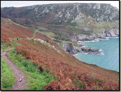
DAY 4
The superb path Sue and I followed to Prawle Point was totally deserted.
 The coastwatch station at the Point was being assiduously manned by volunteers.
We were relieved that we didn't meet the giant ants that built these! 
Here's the rough way ahead to Sleaden Rocks, on the way to Start Point. 
This adder was only about 6 inches long. 
And finally Start Point's lighthouse comes into view. 
The end of our 50 mile jaunt over 4 days - Torcross - is now in sight.
Strangely this sign indicates 168 miles to Poole. So we've come 6½ miles since leaving Plymouth!?

On a stormy night in January 1917 the fishing village of Hallsands collapsed into the sea. Today only these ruins remain. Natural disaster or political conspiracy? Find out more here.
One of the commonest and most colourful of the many flowers seen on this trip was Common Toadflax. 
Our journey, for the time being, ended in Torcross, just beyond this strangely named hostelry, where WG Grace appears to be slogging into the sea. 
Considering the time of year, the wildlife was abundant, with Martins and Swifts gathering for migration, little egrets in the Erme estuary, Red Admiral butterflies, stonechats and wheatears beside the paths, and oyster catchers and many gulls, cormorants and shags on the beaches and coastal rocks.
We noted about 30 bird species and 40 common flowers during our wanderings.
No comments:
Post a Comment