Sue and Martin in Mallorca 2019

Sue and Martin in Mallorca 2019
On the Archduke's Path in Mallorca

Saturday 3 April 2021

Lechtal Alps Backpack - Day 10 - Pettneu to Leutkircher Hutte


Monday 21 July 1980 - diarist: Dave, then Nick - Pettneu to Leutkircher Hutte 

Dave

Woke up very early on to a sound and light show by mother nature. [Meanwhile, the Mk IV brigade also woke - to the crunching of rubbish by a local field mouse; it took two attempts to discourage it - nearly trapped it in Colin's boot. - M] Discovered that tent was in the middle of a puddle, with a stream flowing through the top. Also the river got ominously louder. In the morning, thanks to leaky groundsheets in both tents, everyone's sleeping bag had got a bit wet, especially Ruaridh and Colin's. 

The Mk IV crowd got their tent down first and bogged off to the town. Nick and Dave followed 15 minutes later and met them at the railway station, where times of trains to Zurich were obtained (by Ruaridh of course). We went to a supermarket, where the food commissar (Nick) and his lackey (Martin) bought lots of food.

 Everyone bought chocolate, postcards, etc. Colin got some film but failed to get ice-axe protectors or slings. We then (eventually) set off in the direction of Leutkircher Hutte at 2250 metres.

A torrent near Pettneu

Toiling uphill in a monochromatic landscape - I'm surprised to find any pictures at all!


It was raining when we set off; this turned to sleet half way up, and eventually to snow near the top. The wind also rose so that it was impossible to see further than 100 yards for long periods.

Unfortunately Dave begun to feel the effects of lack of food and the lazy day on Monday, and lagged further behind until everyone else was out of sight. [But the rest could see him! - M] The path to the hut was easy and gentle, but occasionally got hidden by the flying snow.

We eventually reached the hut at about 3 pm. Much washing, drying, drinking, postcard writing, eating and card playing. But no beer drinking!!!

Hope tomorrow's weather is better so that we can go to the next hut. Also hope that if we get bad weather again the fast people learn to use a bit of common sense. 

Nick

This day was a disaster, diary wise. Maybe it was because Dave needs beer to lubricate his writing hand. There wasn't even an after dinner teewasser. Very cold outside by bedtime - freezing hard. Tomorrow we are on the R601 again, to Ulmer Hutte. 

A good meal was had at the Leutkircher Hutte. Soup (with or without sausage), and then spaghetti or meatloaf and noodles.

Today's route - 9 km with 1050 metres ascent in atrocious conditions

Friday 2 April 2021

Thursday 1 April 2021 - Around Thurstaston


With Lockdown restrictions having been relaxed this week to permit outdoor gatherings of up to six people, it was a pleasure today for Graeme and me to be joined by Sue and Jenny, and to be allowed to travel a little further from home - Thurstaston, so named by the Vikings.

After a long break, we could continue to carry out a recce for one of Jen Darling's walks in West Cheshire and Wirral. I'd visited the area before, most recently in June 2019 on another of Jen's routes.

This time we chose route 30, starting at the Wirral Way car park (£2) near the visitor centre down Station Road (SJ 239 834). We started walking from the Max Kirby Bridge, heading past the station platform beyond which we would have started from had we taken a left turn to park.

There's an information board that you should be able to read if you click on the image and magnify it. There's lots of information, including the fact that the Parkgate to West Kirby line was operative from 1886 to 1962, and Max Kirby was a past President of Wirral Footpath Society who died in 2014 at the age of 92.


We tried to visit the Visitor Centre, but it was shut. A lone coot provided the foreground to our view across the silted Dee estuary to the hills of North Wales.


We marched off, back to the well used disused railway line, heading towards Heswall.


Dungeon Bridge was soon reached. Jen notes that the brick bridge is good for echoes. She's right.


A left turn past cowslips then took us along a narrow path and up to some woodland that houses some caves and the only natural waterfall in the Wirral.


A bench at the high point of the dell ('Dungeon' means 'dell' in this instance) secures a view to the Point of Ayr lighthouse in Wales - indistinguishable in today's haze.


Here's a view of the dell from the top of the unremarkable waterfall.


Hardly a raging torrent!


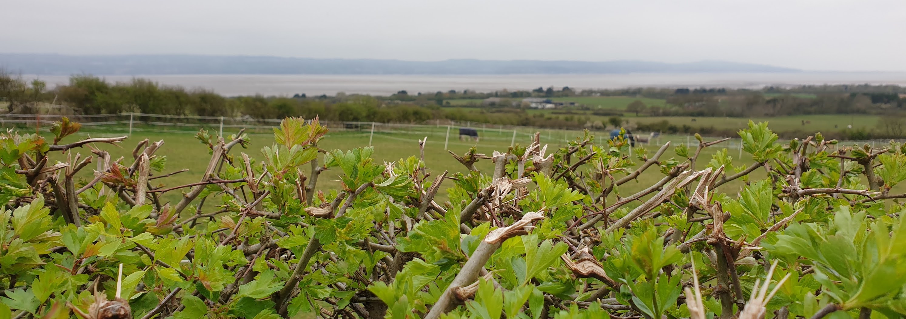
We soon turned left towards Thurstaston and headed towards the spire of St Bartholmew's church, still with views over a hawthorn hedge and across the Dee estuary..


After a group photo, we passed the church, the third reincarnation of which was built relatively recently. The original Norman building (10th Century) has long gone, but the tower from a second church, most of which was demolished in the 19th Century, remains in the churchyard, as you can see below.


Just up the road from the church, the Cottage Loaf Inn would in normal times be a source of refreshment. Sadly not today.


Beyond the inn, a good path leads through Thurstaston Common to a trig point.


The path continues past an orientation point on a sandstone pillar. (Click on any of these pictures for a better version/slideshow.)


There are good views from here, towards the landmarks of Liverpool, as well as more local points of interest like the globe-topped column on Caldy Hill. Today the gorse was in full bloom, and we made our way through it accompanied by the scent of coconut.


A gap in a wall signifies progress from Thurstaston Common to Royden Park, where a luxury hotel, Hill Bark, stands. It's surrounded by a high fence, so I should have taken a photo from further away!

The building was constructed on Bidston Hill in 1891 for R W Hudson, a soap magnate. In 1931 it was moved, brick by brick, to its present location, and re-named Hill Bark.


Whilst we didn't see distressing amounts of litter today (not compared with West Sale, anyway), the path around the hotel did reveal some women with a large number of unruly dogs. "They are always here, they think they own the place" commented another lady with an obedient little companion.

We turned left down a forest ride, and before reaching a road, Montgomery Hill, we continued left along the ride, through an area of Scots pine, before reaching the road again and walking along the pavement back to where we had nearly reached the road a few minutes earlier.


Anyway, soon after this we turned left down a private road towards Birch Heys, passing Royden Manor and Birch House on the path towards Caldy.


After descending to Grange Cross Lane on a path I recognised from a previous visit, we took a delightful route through Stapleton Wood, an area of mixed woodland named after Olaf Stapleton, a local philosopher and science fiction author.

This brought us onto Caldy Road, for a short walk along the pavement into Caldy, which Greame surmised might be the 'Alderley Edge' of the Wirral. Apparently the village consisted of a few fishermen's huts and cottages until 1832, when a Manchester businessman, R W Barton, set about improving the village by constructing the red sandstone dwellings with black and white timberwork that you see today.


Primroses grow in the verges in this village.


Graeme, and the rest of us, found the sight of this 'neo-Alderley Edge' grotesque construction somewhat distressing, near another splendid but 'original' mansion where he has other memories.


Having had an elevenses break near the tapping woodpeckers of Royden Park some time earlier, we now re-joined the Wirral Way and broke our stroll along the old railway line, dodging bicycles and prams, by heading into Dawpool Nature Reserve for a lunch break.

Child labour was being deployed here for litter picking, but they seemed to be happy enough.

A short stroll returned us to the car park by Max Kirby Bridge, to conclude a most pleasant outing.


Jen reckons this walk is 11 km, but my GPS recorded 13 km, in a leisurely 4 hours including breaks.


Next week:
Friday 9 April - 10 km in Delamere Forest. Meet at Barnbridge Gates car park - SJ 542 716. Let me know if you plan to come, as the 'group of six' limit will still apply.

Thursday 1 April 2021

Lechtal Alps Backpack - Day 9 - Ansbacher Hutte to Pettneu


Sunday 20 July 1980 - diarist: Colin - Ansbacher Hutte to Pettneu 

As today had been designated a rest day I had expected to be gently roused from my slumber. However, first thing this morning I heard the sound of an approaching avalanche - was this the end of the British Loonies? No, just Dave snoring. Martin had been similarly disturbed and kicked Dave violently; this had the desired effect and we dozed on a while longer. 

After a leisurely breakfast we settled the bill, packed and unpacked our rucksacks, and set off in the wrong direction. 

In an attempt to reach the correct path, we started traversing across the hillside. This involved negotiating several deep gullies. Martin and Nick, feeling less suicidal than the others, decided to continue down to reach the valley in Flirsch.

Blank-Spitze and Hoh Riffler

The rest of us continued to scramble precariously across the hillside. Ruaridh and Dave decided that even this was not difficult enough and started passing rucksacks to each other. Eventually we found the path - a two foot groove heading down the hillside to Schnann. 

Passing the Fritz Hut it became a multigroove, as people had cut off corners from the original path. We lunched above Schnann and spotted a white hat in the village - this we later confirmed to be Martin.

Nick on the road to Schnann

A train at Pettneu

The trog along the road to Pettneu was hot, sticky and miserable. We found Martin and Nick in the middle of Pettneu and we all collapsed on a bench. As no-one had much energy we spent quite a while eating slightly more than half the dried pears. Just as we were about to make a supreme effort and leave, a group of people headed towards us - it was a Sunday afternoon procession. At its head were four horses which seemed fairly nervous as they passed five scruffy loonies. One of them presented us with a 'sausage' (although Martin thought it was more like a pancake). The horses were followed by two brass bands; one trumpeter seemed unable to control his music and as he passed us he dropped it; much to the amusement of ourselves and his fellow bandsmen it landed right in the tracks of the incontinent horse. 

Enlivened by this, we set off through Pettneu and headed for a valley on the opposite side of town. A suitable campsite was found, tea and/or coffee drunk, dinner consumed, postcards written, a shopping list for tomorrow prepared, and I wrote this - far too long for an uneventful day's diary entry.

Today's route - 8 km with 150 metres ascent (Nick and Martin went by the path to Flirsch)

Wednesday 31 March 2021

Lechtal Alps Backpack - Day 8 - Memminger Hutte to Ansbacher Hutte


             Getting ready to leave Memminger Hutte; Ruaridh cleans his teeth

Saturday 19 July 1980 - diarist: Martin - Memminger Hutte to Ansbacher Hutte 

The sojourn at Memminger Hutte was hot, and even our socks started to dry out. Self cooked breakfast was more appetizing and cheaper than the average hut's fare. We left in a leisurely manner after a buxom fraulein had prostrated herself on a mattress next to Colin, and the customary readjustment stops - Colin (to adjust his clothing), Nick (to keep face) Dave (to degaiterise), Ruaridh (ice-axe installation) enabled me to speed ahead as usual.

Mating Salamanders

Route 601, and the view to Rote Platte

By 11 o'clock we had descended (slid) down to where route 601, our 'path' for today, crossed the Parseirtal. A brew and much washing of feet etc was most welcome as the path had been unusually muddy and very liable to subsidence. Dave had another spectacular slide, this time down a tree trunk. He is now very muddy. 

Black lizards, gemser, a marmot, and a plethora of alpine flowers complemented the alpine scenery. An hour was spent brewing and Nick disappeared for a bath.

The view south from Parseierbach

The route ahead

Rote Platte from Route 601

The long ascent to Griessl Sch. (about 800 metres) became very difficult as the snow deepened and it became apparent that no one had attempted the route before us. At this point Dave had a slide and a rest over a 10 ft drop with a thin layer of snow - previously Nick had been dragged out of this hole by his rucksack. Some difficulty was encountered in safely negotiating the massive cornice at the top of the slope. At this point we did not partake of a third lunch, but traversed through deep snow towards Winterjochl. 

Amazingly, an isolated section of scree revealed a red path marker. We were still on route 601! After a Mars bar each, and much relieved to know we were in the vicinity of the path, we traversed from Winterjochl past Stierkopf to the col leading to the Ansbacher Hutte. After more deep snow, and red path markers, we reached this broad col (at which point RMP produced the highest level 'sausage' of the holiday to date - 2400+ m), from which the panoramic view stretched far and wide.

Hoh Riffler from Kopf-sch via Winterjoch (2528m)

The two glaciers on Hohe Riffler were prominent, and the hut was visible. A further traverse brought us to the hut - a high one at 2376 metres. The warden was a little surprised to see us and confirmed that we were the first to walk this section of route 601 this year. "The English Pioneers." A satisfying meal of goulash soup and meat and vegetables and noodles was soon provided.

Looking down the valley from Ansbacher Hutte - 2376 metres

Today's route - 10 km with 1000 metres ascent

Other events of the day included Dave smashing Colin with his ice axe, Nick trying to extract his jaw with his ice axe, everybody falling down lots of holes, and Nick's expletives. 

Deep snow was today's dominant feature. Everyone, except of course Dave, feels like taking a rest after several hard days. 

Historical notes:

1. The warden informs us that the snow is worse this year than any year since 1930.

2. The hut was built in 1906 and has not (unlike Memminger) been extended since then. Our room would have been cosy if it had been heated, with very pleasant wooden panelling, and gas lights - there's no electricity here. 

Tuesday 30 March 2021

Lechtal Alps Backpack - Day 7 - Wurttemberger Hutte to Memminger Hutte


Friday 18 July 1980 - diarist: Ruaridh - Wurttemberger Hutte to Memminger Hutte 

As the only part of my anatomy protruding from my sleeping bag, my nose detected that it was cold this morning. A good sign as it suggested a cloudless sky. This was confirmed as Nick whipped open the tent door and bright sunlight dazzled my eyes. The light was reflected off the mountains opposite, however it would be another couple of hours before the sun started warming the tent. (Now 6 am.) The mountains looked just as they should, stark and clear, shining white against a brilliant blue sky. 

Breakfast as usual - even the Primula cheese tube split as usual - with one of our three different types of muesli. The powdered milk refused to mix properly at the ambient temperature and had to be heated. Nick and Dave had ice on their flysheet.

Despite staying outside the hut (just), we signed in as recommended so that our movements could be traced if we went missing (click on the image for a better version)

The WW1 memorial outside Wurttemberger Hutte

At about 7:30 Rudolf wished us good morning as he set off for the Memminger Hutte. 

We covered ourselves with Nivea, glacier cream, floppy hats, sunglasses, goggles, etc, etc. Martin said he felt silly putting suntan lotion on, with his cold soggy feet! 

A cheery farewell from the warden and we hit the trail. The snow came as a surprise - frozen hard and crunchy, a distinct contrast to yesterday's soft wet variety. Soon after reaching the sun, however, it was back to the soft sort.

Looking back to Wurttemberger Hutte (can you spot it - middle of picture, far right?)

Up to the Grossberg, the path left the snow and went up over rock, rather than taking the lower point of the ridge. We stalked a ptarmigan (with camera) but failed to find a nest.

On the ridge, with a view up to Grosberg (2612 metres)

View from Grosberg, looking south

A view back down the ridge

The views from the ridge were marvellous, the first decent views we have had. The path continued along the ridge - very interesting, with fixed ropes and tracks across the very top snow, a 6-inch wide ridge. 

Following the guidebook, we took the path to 500 metres beyond the point where it left the ridge, and after a pause we went up the snow to the Kleinbergspitze. (Why is it that the Kleinberg is 300 metres higher than the Grosberg?)

A view from Kleinberg Spitze (2756 metres)

We were grateful for the snow, since even in its very soft state it was preferable to the scree. The views were superb, and we picked out all the main peaks near and far - Parseier Sp, Hoher Riffler, Freispitze, Rote Wand, Muttekopf, Dremel Sp, Bergwerkkopf and Wildspitze (Ostal). 

To judge from the scrap of paper in the tin at the top, the summit is visited only every other year on average, and we added our names on the back of a chocolate wrapper. 

Nick on Kleinberg Spitze

We decided that the routes near the Parseier Spitze were impassable and it seemed extremely unlikely that we would be going to the Augsburger Hutte. 

The view of ridge after ridge of grey, green, blue and white peaks stretching for mile after mile, and the still air (hardly a breath of wind) could have kept us there all day, but we finally stirred ourselves and plunged back down to where we had left our packs. The next kilometre or so to the Seescharte was along the level in snow - not hard but the concentration had to be on putting feet in the right place, with little chance to admire the view.

Along the path, Dave suddenly disappeared from view. Martin found him grinning broadly in a snow trough, having slid down and bounced over a large rock. 

Coming down the far side of the 'scharte' we discovered how tired we were as we had to contour ourselves with walking and sliding down the snow rather than running as we could have done at the beginning of the day. (Speak for yourself - this does not apply to Dave, who as is usual is far fitter at the end of the day than at the start - he arrived at the hut ten minutes ahead of the others - with sore knees - Dave.) 

Approaching the hut, we met a young fellow collecting stuff from the goods seilbahn. Our suspicions that the route to the Augsburger Hutte was out were confirmed, so it looks like the Ansbacher Hutte tomorrow.

The view west from Memminger Hutte (2242 metres)

Today's route - 8 km with 750 metres ascent

Vast numbers of people at the hut - of course, it's Friday evening. The tourists are very impressed with where we have been - Nick enjoys an ego trip. Any ideas of camping rapidly evaporated when we discovered that the only flat patches of grass not covered with snow were extremely exposed, with no water to hand. 

We booked into the hut, and when Nick followed Martin's rather ambiguous directions to the matratzenlager he ended up in the warden's daughter's room. He thought, in present tired condition, that Durchgang verboten probably meant 'Smoking forbidden' or something similar. He soon woke up though when he decided to wash his hair and stuck his head under the tap before testing the temperature. Colin and I  confirmed our masochism by washing in the icy water. 

We tried ordering a litre of Teewasser and made our own tea and coffee. A much better idea than just ordering a litre of tea - although next time we must remember to ask for fresh milk rather than using our own milk powder. 

Ordering of meals was slightly unusual in that we had to wait until 6 pm, but when the food came it was appetising and filling. Martin has still not learnt how to pour beer without it frothing over. Dave and Nick each managed to order drinks themselves this time! Mind you, Nick had it done for him - the barman told him what he wanted - he must have heard us discussing the order.

(The entry concludes with incomprehensive scribble from Dave, seemingly connecting Ruaridh with the barmaid's large protruberances.)

At some point today or tomorrow, we lost Rudolf, who got fed up with the deep snow and lack of path markings, so he went home.