Sue and Martin in Mallorca 2019

Sue and Martin in Mallorca 2019
On the Archduke's Path in Mallorca

Saturday 8 May 2021

Saturday 8 May 2021 - The Cob, a Nature Trail, Portmeirion and a pond


A rainy morning provided the perfect excuse to stay at home and watch the comings and goings of the harbour from the comfort of our couch.

The afternoon brought better weather and an opportunity to leave the car behind and take a stroll across the Cob, the Glaslyn estuary's antidote to invasion by sea.


The path beside the narrow gauge railway line is lined just now with the blue and yellow flowers of ground ivy and birdsfoot trefoil. Egrets patrol the seaward side of the structure. 

The trains are operating a limited service.


There's apparently an excellent cycleway along this section of coast. Must try it sometime, though I suspect the busy roads in the area would necessitate a 'there and back' route.


Beyond the Cob, pleasant woodland leads through beds of bluebells to the interesting site of Portmeirion.


A new Nature Woodland Walk has been devised, using all manner of discarded objects - boots, helmets, teapot, radio, kettle, etc.


From a viewpoint above the trail, the panoramic scene was rather more subdued than it would have been in yesterday's sunny weather.


I found this variegated ivy eye-catching.


The nature walk passes a couple of Bug Hotels.


Well done! whoever created this short trail, and laid the blue string that keeps visitors on the straight and narrow.


Judging by the frantic activity at the bird feeders, they must need frequent attention. 

After enjoying a figure of eight loop to the fences surrounding Portmeirion, which must be a 'pay to enter' village, we returned over the Cob to pass a building site guarded by this chap.


Here, there's a tidal pond, home to many more bird species. Normally there would be a mountain backdrop, but today the cloud was well and truly down.


Here's our 9.5 km route from home, which is marked by a small purple circle. A well spent couple of hours with little more than 100 metres ascent. Click on any picture for a better image.

Friday 7 May 2021

Friday 7 May 2021 - Brithdir and Foel Caerynwch


On a sunny morning we breakfasted in front of the above view of the harbour from our living room.

Eventually we set off on a 40 minute drive to Brithdir, just beyond Dolgellau. Our walk started down a lovely path beside the Afon Clywedog gorge - known as the Torrent Walk.

Whilst most wild garlic is still in bud around here, for some reason there are patches of flowers in this spot. Sue collected some leaves to supplement our dwindling supply of lettuce.

We met a couple who had seen firecrests and nuthatches on their way up the valley. They were the only walkers we saw all day.


Making our way to the forest of Coed Dolgwartheg, we admired the expanses of bluebells and the moss covered vegetation.

Around here we passed a memorial to Evan Jones (1820 - 1852), neatly placed in the wall of the ruined building in which he must have lived.

We also passed a hotel that may be used by HF Holidays, as there was another plaque in tribute to HF and local ramblers, who had been responsible for improving some local paths.


Near here, a section of the path, which must be only rarely used, was obscured by fallen branches and moss covered boulders. It was a minor surprise to emerge from this vague memory of a path at the gap in a wall predicted by Alex!


We saw a pair of nuthatches in the Coed Isaf woodland, as well as pied wagtails, thrushes and robins on the edge of the forest, where we found a comfy spot for elevenses. 


Eventually we emerged from another tranch of forest, beyond Helygog. I wonder what will replace these felled trees?


Soon we were on the open fellside of Glasgwm, with fine views towards the Rhinogs, and in the other direction the distant Moelwyns. It was a fine spot to stop for lunch. We donned waterproofs, but the two rain showers passed either side of us.


After descending to Brithdir and admiring the remains of a Roman fortlet (aka police post) that comprised a flat piece of land in a field, we continued on to join what is apparently the unsignposted route of the Cross Britain Way, an alternative coast-to-coast walking route, 279 miles from Lincolnshire to Barmouth.

We soon turned off to ascend to the 343 metre summit of Foel Caerynwch, our highest point of this trip, with fine views pictured below.


After taking an anticlockwise route over this hill, a well waymarked route by way of numerous posts with white blobs, we found ourselves back at the fortlet. 

Soon we had rejoined the path of the Cross Britain Way. This was not an imposition as it enabled us to admire the splendid garden at Ty'n-Ilidiart. This time the owner was outside and we chatted for some time:
"Are you going up the Pimple?"
"We've already been up it. What a splendid day..." and so on.

From here it was a straightforward walk back to the lay-by from which we had started, near where we passed a spring next to a farm.


Here's our route - clockwise with a small anticlockwise loop, starting from the south eastern corner of the wooded valley on the left of the map, denoted by a small purple circle. 16 km, with 550 metres ascent, taking us rather less than five hours.
Another excellent outing. 
(Click on the map for a better version.)


Thursday 6 May 2021

Thursday 6 May 2021 - Lledr and Llugwy


After a half hour drive to Dolwyddelan, we donned waterproofs almost as soon as we had set off up a path through the forest on a track that headed towards Capel Curig. 

We stopped for a lengthy chat with a chap who was wild camping in the forest. Happy days!

By the time we reached a 301 metre spot height, we'd left the forest, said hello to a couple of other walkers and a polite motorcyclist, and were able to admire the view ahead to snow plastered Glyderau and Carneddau (above) and to the nearby summit of Moel Siabod (below).


A little further on we paused for elevenses. Very pleasant as long as you were well wrapped up.

At the bottom of the hill, in woodland on the outskirts of Capel Curig, we came across a house we recognised. We have stayed there. It belongs to a climbing club, and we visited as guests a few years ago. I remember walking up Moel Siabod from it. Was it the weekend of Richard and Melinda's wedding? I know they were members of the club.


From there, a 2 km walk along a quiet lane, empty of traffic apart from the obligatory Post van, took us to the bridge next to the Ugly House café, which was open for business.

We crossed the bridge and took the excellent path to Swallow Falls, towards which there are several viewpoints along the way.


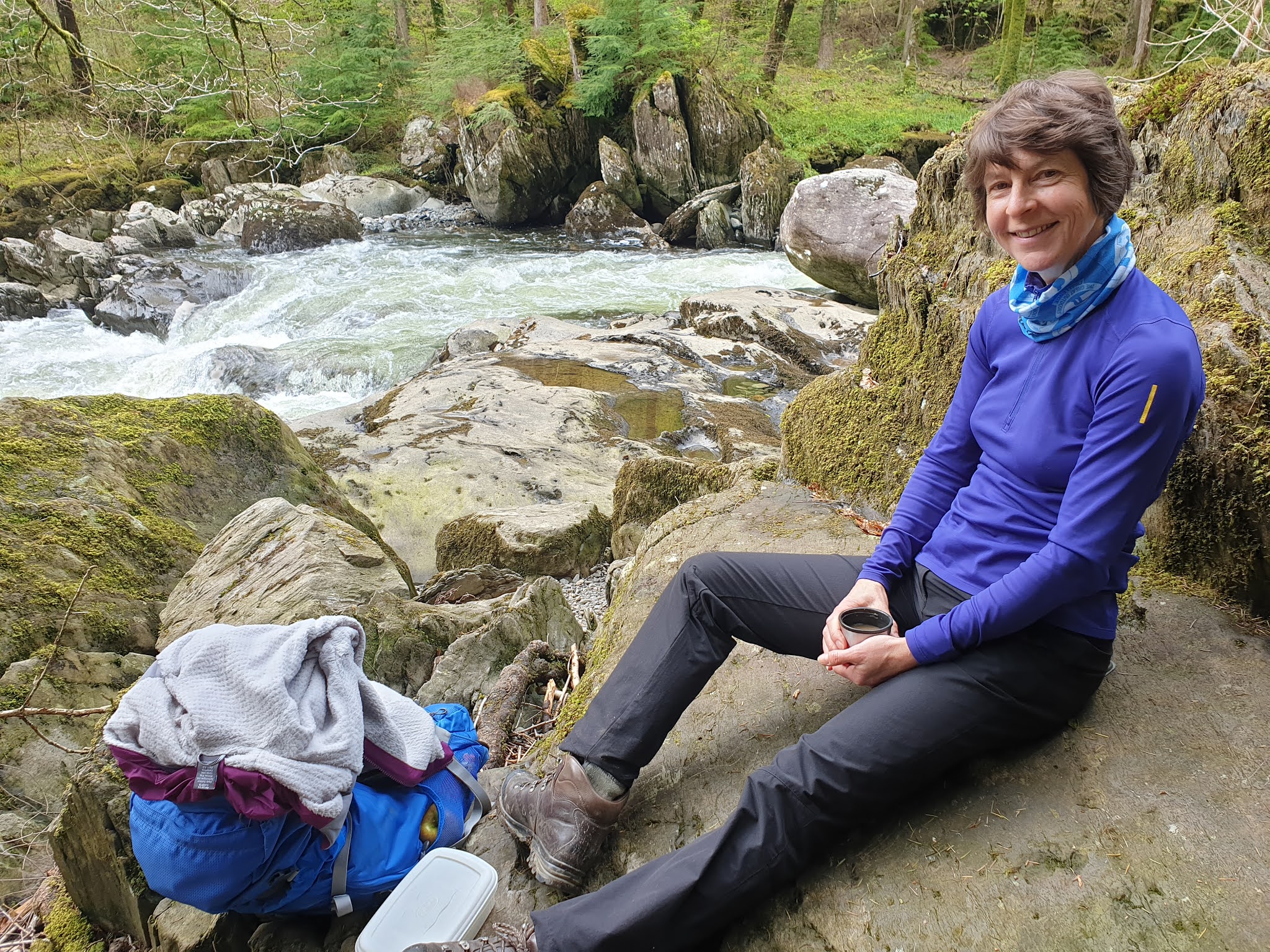
We enjoyed lunch beside the torrent, where dippers and grey wagtails were in their element.


The woodland was delightful, as we wandered on towards the Miners Bridge, which Alex describes as 'a stepped footbridge'. 


Here's the 'footbridge' today.


Yes, 'gone, an ex footbridge'. 

A 3km diversion via Betws-y-Coed got us across the river, and back on course on a direct route back to Dolwyddelan. More lovely woodland, with verges filled with dog violets, wood anemones, wood sorrel, lady's mantle, bistort, lesser celandine, cuckoo flower and many more. Woodpeckers clacked in the trees, and a bit later a Swallow fooled us by perching in a tree, leaving us puzzled as to its identity until it flew off.


The track we followed back to Dolwyddelan was pretty straight for a good reason - it forms part of the Sarn Helen, a Roman road linking north and south Wales. The track is nearly 2000 years old.

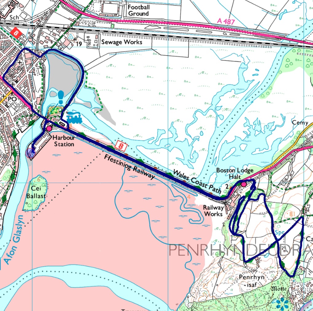
Here's today's route - 23 km, with 600 metres ascent, taking us a little over six hours. Another excellent day out. We saw at least a dozen folk out walking today, plus tourists in Betws-y-Coed. 


Wednesday 5 May 2021

Wednesday 5 May 2021 - Nanmor and Aberglaslyn


We set off slightly earlier this morning, which meant that we copped the 10:30 shower of hailstones. Not to worry, the weather behaved itself after that.

We had parked by a bridge over the Afon Glaslyn River about 1 km south of Beddgelert, a 15 minute drive from home, with the objective being a 17 km clockwise circuit via the Nanmor valley and Aberglaslyn.

The Riverside scene in Beddgelert is pictured above.

A pleasant path took us to a lane and past the Sygun Copper Mine (closed at present), then happily up to a lake, Llyn Dinas.


Snowdon was seen clearly in the distance, the cloud having risen above the mountain's white cap.

Across the valley, the small summit of Dinas Emrys seemed an unlikely venue for the first appearance of Myrddyn, known in English as Merlin, in British myth. The story of a fight between two dragons is also the origin of the tale behind the red dragon's appearance on the Welsh flag. I won't go into the complicated story involving Saxons, Britons, wizards and a boy born to a virgin mother any further just now.

A lovely path took us alongside Llyn Dinas to an ideal elevenses stop, beyond which 3.5 km of quiet tarmac saw us well into the Nanmor valley. Beside the road we saw a heavily horned wild goat, a crested tit, a willow warbler, and a meadow pipit. Cuckoos were vocal, if not visible.

After leaving the road, a concessionary path took us towards a house called Buarthau, before which a warm slab of slate provided an excellent venue for lunch. 


Beyond this, we passed through some lovely sunlit woodland. 


The path continued, faint in places as it seems little used, to cross open land before entering the forest of Dolfriog and making its way to a lane that led us to the hamlet of Nantmor.

After crossing the narrow gauge railway, we made our way to the Pass of Aberglaslyn, through which the Glaslyn river passes as a torrent. We saw more people on this short section than for the rest of the day, and not many even then. An old mine working contained a discarded coffee cup, the only piece of litter I saw all day.


We soon passed a shelduck and arrived back at the bridges across the river from where we'd started, and here we assisted a couple who were engaged in a debate as to the location of the copper mines. (They had made a fundamental error in Beddgelert  - not to worry!)


The view from the bridge showed threatening rain clouds, so we had finished our walk at an opportune time (2:30).


Here's our route, another good one - 17 km with about 400 metres ascent, taking us 4.5 hours. An excellent outing, and then back home for tea and biscuits, a game of Boggle, and a delicious meal.

Click on any image for a better version.

Tuesday 4 May 2021

Tuesday 4 May 2021 - Moel-y-Gest


Breakfasting to the sound of hailstones bouncing off the deck, we weren't encouraged to leave the cosy safety of our house with any urgency. The oyster catchers, had we been able to see them, were probably flying backwards. 

So it was 11 o'clock before we set off. I know that because the first picture of the day was of Prince, heading up the 11.05 to Tan-y-Bwlch.

We've been up Moel-y-Gest numerous times. Today we chose Alex's route, taking the coast path to Criccieth then heading over the main summit, whilst by-passing the lower of the mountain's twin summits.

After walking along the sea-front at Borth-y-Gest, the route takes a lovely path between the sands and a golf course. 


There was a very convenient bench for elevenses and a chat about gaiters with a Welshman, one of very few people we saw out walking today.


Black Rock Sands turned out to be a 2.5 km sandblasting experience, with swirling sand, but on reaching the outskirts of Criccieth we entered the relative calm of the lane to Treflys. Here, there's a small church, St Michael's, beside which we enjoyed lunch with Thomas and Jane Jones on their lovely warm tombstone.


A little further along the road, we enjoyed fine views generally, and in particular of today's mountain objective.


A steep climb past bluebells and primroses brought us to a broken stile and a pause for breath on the pretext of doing a bit of editing for Alex.

Here you can see Moel-y-Gest's lower summit, together with the Glaslyn estuary.


From here, a short if steep climb brought us to the 263 metre summit of Moel-y-Gest, possibly one of the best viewpoints in Snowdonia. To the right in the next picture are the distinctive features of Cnicht and the Moelwyns, and below that is the view towards Snowdon, on which the fresh snow is capped by a sea of cloud.


We headed back along the crest, trying to follow Alex's route description. We just about succeeded, but given the large number of paths up here you could simply say 'follow the crest of the ridge taking paths to the left (north) to reach the bealach, from where you can either contour left to by-pass the lower summit or head straight over it on a clear path, in either case heading down towards the town'. Either way, you get views like this.


We were back at base after this 16 km walk by before 4pm, at which point the hail returned. It was good to be able to view the precipitation from the comfort of our sitting room behind a tray of tea and biscuits!

Here's the (clockwise) route - by some miracle Anquet failed to crash for four walks in a row - 16 km, with 400 metres ascent, in rather less than 5 hours. The light blue line is Alex's GPS download.