Sue and Martin in Mallorca 2019

Sue and Martin in Mallorca 2019
On the Archduke's Path in Mallorca

Saturday 27 July 2019

Friday 26 July 2019 - Around Daresbury

 
Paul B and I were the only takers for this pleasant stroll in warm weather close to home.
 
About 50 metres after striding off on our walk we came to an unpassable obstacle, the Dormouse Tea Rooms.
 
Duly satiated, our attention returned to the job in hand, as we sauntered out of the pretty village past cottages that date back to the 17th Century.
 
 
We had a mixed experience today of footpaths through fields of crops. Starting with this narrow route through a field of cereal crop. "Well done" that farmer.
 
 
Our route was based on Jen Darling's 'Around Daresbury' in her 'More Pub Walks in Cheshire and Wirral' book, where a detailed description is available, or you could just follow the route on the map that appears at the end of this posting.
 
After passing under the M56 motorway, we wound our way past Little Manor Farm and Hallam Hall Farm to reach Morphany Lane near Morphany Hall.
 
On the right down here is the site of the parsonage where Lewis Carroll, born in 1832, spent his early years. There's a plaque, and some information boards, and I wrote about this site and its connection with Lewis Carroll in this posting in 2009. Click on the images below for more readable versions.


You'll see from my 2009 posting that the decorative ironwork over the parsonage's well is a more recent addition. The rooms of the building are laid out between brickwork on this meticulously maintained site.
 
 
Moving on, a left and left again manoeuvre took us past Black Jane Farm, a Georgian building of symmetrical design, dating from 1729. They must have been neighbours of the remote parsonage. According to Jen, Black Jane herself is reputed to have been a swarthy-complexioned farmer's wife who brewed very potable ale!
 
 
The approach to the farmyard of Queastybirch Hall was blighted by the absence of a proper path at the side of a ploughed field, but the chap at the farm who was laying concrete was jolly enough to share a joke. Then, after the path had joined the Delamere Way, the path beside a field of giant lettuces was even less discernible.
 
 
Steep steps led to a bridge over the M56 and to the village of Hatton, from which our 2009 walk was based.
 
We found a good route along Goose Lane and past Greenside Farm, to minimise road walking through Hatton, re-joining Jen's route at Hatton Hall. We then skirted a stream and followed several kissing gates to enter Row's Wood. This is where shorts were not a good idea, and we were both pleased to find a good supply of dock leaves. Nobody's fault other than the locals of Hatton and Daresbury, who clearly don't walk this path often enough during the nettle growing season. (A similar accusation could be made of me and Sue concerning the ginnel leading to the canal at the end of our road.)


After this, it was a straightforward walk down Hobb Lane to the familiar sight of 'Duck Corner' on the Bridgewater Canal at Moore. We pass through here on our  regular Phoenix Park/Norton Priory bike ride.
 
 
There weren't as many ducks about as usual. The ones who were there were looking very chilled in the cool water of the canal on the warm day.
 
 
After just a short stretch of canal, we left it at the next bridge and found a lovely straight path through the crops, back towards Daresbury, with Daresbury Laboratory, opened by Harold Wilson in 1967, broadcasting its presence by way of the huge concrete cylinder of the former Nuclear Structure Facility which was based on a Van de Graaff accelerator.
 
 
More nettles and brambles at the end of this field gave us a few final stings and scratches before we clambered up to cross the A558 expressway and take the path back to Daresbury.
 
Here's our route (click on the image for a better version, as with all these images) - 14 km with about 120 metres ascent, taking us three and a half hours including stops (two tea breaks as well as the tea room - it was a hot day).
 
 
What a fine way to spend a summery Friday morning. Next week, on Friday 2 August, I'll be at the following venue, should anyone care to join me:
 
Lamaload Reservoir and Shining Tor. An 11km trip to the highest point in Cheshire. Start 10 am from car park at north end of reservoir (SJ 975 753).

Friday 26 July 2019

Thursday 25 July 2019 - A Sale Sizzler 5 km Race!

 
I'd never run a 5 km race before, and various people had suggested this one would be "fun". It was the third in a series of four races organised by Sale Harriers and taking place on the familiar 'Sunday' course at Wythenshawe used by Great Run Local.
 
I cycled down and arrived nearly half an hour before the start. What a contrast to the non-competitive runs that we are used to doing here! There were hundreds of people in club colours collecting their numbered tabards, which incorporate a timing chip, and warming up for the event. The top picture shows the scene about twenty minutes before the start.
 
The whole thing was very well organised, with goodie bags full of flapjack laid out for finishers to collect in due course.
 
 
Still a few minutes before the off - there are some familiar faces amongst this lot below. You gather roughly according to expected finishing time - on Richard's advice I started well back to avoid being 'trampled'.
 
 
It was very hot and humid. Even cycling slowly for the 6 km from home had induced a lather, so the table laid out with many cups of water was most welcome both before and after the run.
 
It wasn't the evening for a fast pace, but people were racing. Whereas on the parkrun, many folk are happy to chat, here I got a rather frosty response (ie no response) to my attempts to open conversations along the route. "It's because they are racing" explained Richard later, after he had smashed his personal best despite the conditions.
 
I'll be running in the fourth and last event in this series in a couple of weeks, and I didn't want to set a difficult target time to beat, but even the slowish time of 23.59 was hard work in the heat and humidity. That got me to position 317 out of 676 finishers, and third out of eleven in my age category - about two minutes behind the first two. I was happy with that. The result came through pretty instantly - just a few seconds after finishing - by way of a text message. Very efficient, thanks to 'niftyTiming'. 
 
I enjoyed a leisurely bike ride home... and a large beer...

Thursday 25 July 2019

Wednesday 24 July 2019 - SWOG visits Dunham Massey

 
Nigel and Sue lead an evening walk from The Swan with Two Nicks for SWOG most summers. We previously joined them on 17 August 2016, when they took a clockwise route, rather than today's anti-clockwise version.
 
By 7.35pm, just Nigel, Cary and I remained outside the pub, waiting for a late-comer whose GPS didn't recognise the nearby new road system.
 
Eventually we got going and we soon entered Dunham Massey's grounds.


Our group of five passed the Saw Mill and caught about 18 others before reaching Charcoal Lodge, happily shining in the late sunshine.


The group then left the park and wandered through the golf course, and made its way to the Bridgewater Canal.
 
 
We proceeded to the aqueduct over the River Bollin.
 
 
This is the last section of towpath before the steps leading back down to the Swan.
 
 
Here's the route - 6 km with minimal ascent, taking an hour and a half at a very leisurely pace.
 
 
I'd arrived early for this walk (Sue is away as her dad had his - successful according to first indications - heart operation today; we wish him well) on my bike so had already enjoyed a beer, thus I was soon on my bike again for the 20 minute ride home, before it got dark.
 
Thanks to Nigel and Sue for venturing out of their normal patch to lead this walk.

Wednesday 24 July 2019

Pyrenees HRP - 2004 - Day 9

 
Sue and Martin's Big Adventure
 
Day 9 - Tuesday 3 August 2004 - Stage 8
 
Postcard Summary (on yesterday's card)
Midge zone to Col d’Uthu
Ascent of Pic D'Orhy (high point to date - 2017m) and misty ridge – 10.3 hours, 21 km, 1350m ascent
Climbed back up to the col, where the shop was terribly stocked, so we have to go without brews for a while.  Then headed up out of the cloud to our highest point to date.  Views were amazing as there was cloud beneath us over France.  The vultures flew close by.  A shame that we entered the mist later as the ridge is a good one.  Camped at a col at 1664m, after collecting water from a spring on the Spanish side.  Sadly no views from here apart from a brief glimpse when the clouds parted temporarily.
 
Diary Entry (by Martin)
Ascent of Pic d'Orhy (2017 metres)
Woke at usual time. 7 am. Darker than usual due to thick mist everywhere. Eventually got up and found hot water for a wash and shave, then we got going without paying at 8.40.
 
Back at Bagargui col we found the food store sadly lacking and we improvised with food for a couple of days. They didn't sell gas, so we bought very little that needed heating, as our second gas is nearly kaput. They would only sell us one baguette, as we hadn't reserved any! We were rather rude to them and said their shop was "terrible".
 
After eating a cheese and small piece of bread breakfast outside the lack of Information Centre (shut), we headed off up Pic d'Orhy. Our mood improved after 15 minutes when we emerged from the mist to a beautiful sunny day. We took photos of the Pic and beyond.


All went well until I took a wrong turning (quite difficult - lost concentration). We went too high and went unnecessarily around a bluff. I then took us too low and we finished up bashing through steep grass and gorse bushes to reach our correct path. (Anything the sheep can do, we can do too!)  
 
This took us onto the ridge leading to Pic d'Orhy (2017m), which we ascended at a leisurely pace, arriving on the summit at 2.15. This wasn't the hottest ascent of the trip - it had been only 16°C at Bagargui col. The ridge was a mini Crib Goch - easier, but a similar amount of effort as to get up Snowdon. The big difference is that despite starting from a tourist centre, no-one else is climbing the mountain from this (the interesting) side, and there are no signs encouraging them to do so.
 
 
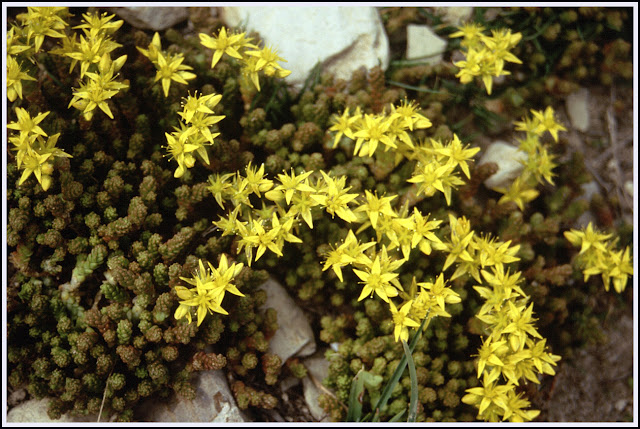
We had found lovely spring water at 1600 metres - a delight. Lots of alpine flowers seen today - perhaps there may be time to record them later, but some Dwarf Columbines and some Saxifrages and Stonecrops were seen, and lots of others.
 
Biting Stonecrop
The tuna salad was surprisingly tasty. We admired the circling vultures together with four day walkers. Horses and sheep live here. Good views down our steep descent to Port de Larrau (1585m)  and to the ridge (our route) beyond. It had the look of a Lakeland fell ridge.  

We dropped down the sunny hill to reach Port de Larrau at 3.20pm. Two French families were lunching in thick mist, oblivious of Spanish sunshine about half a mile away.


We were hopeful of regaining a sunny ridge, but the cloud foiled us and we spent the rest of the afternoon carefully following Ton Joosten's instructions as to how to continue along the ridge. Despite only about ten metres of visibility, and with the aid of altimeter and compass, we arrived at Col d'Uthu (1664m) without incident, having decided not to descend to Ardanne.  
 
The gamble paid off, as we found a spring 100m down on the Spanish side and we returned to flat ground on the col to set up camp above the cows at 7 pm. (Lesson: in mist when dropping down for water, take a bearing and reverse as per descent - we wasted time trying to find the col after collecting water.) 
 
The sky over Spain cleared briefly, but we cooked indoors with the last of our gas, a nice meal, cosy in our tent with mist and rain outside. A rough night for weather, but we slept well and the tent stood up well. 
 
Note: this particular border is patrolled by an electric fence, as Sue discovered to her cost.  
 
Stats and route (Viewranger):

29 km, 1500 metres ascent, 10.3 hours

 
Index

Tuesday 23 July 2019

Tuesday 23 July 2019 – Boom and Skippy visit Timperley

 
Fresh from end of term celebrations, Kate brought J&J (‘Boom and Skippy’ today) to Timperley for a romp in Walton Park and some baked potatoes and ice creams.
 
So, off to the park we boomed and skipped, taking care not to be run over by the many cyclists.
Jacob’s boomerang was hard to capture on film except when stationary.


Skippy’s antics were a bit easier to capture, though you can see Jacob chasing his boomerang in the distance.
 
 
The boomerang won…
 
 
After spending some time recovering the boomerang from a tree, and a frisbee from a thick hedge, the dynamic duo skipped and climbed, then we went home for said spuds and ice creams.


That was a lovely way to spend a hot afternoon. Jacob did get to the top of the pole, but my camera was stashed at that point, when I was poised to break his fall!

Monday 22 July 2019

Pyrenees HRP - 2004 - Day 8

Pyrenean Eryngo (Eryngium bourgatil)
Sue and Martin's Big Adventure

Day 8 - Monday 2 August 2004 - Stage 7
 
Postcard Summary
Cowbell camp to near Bagargui Col
Superb mountain day with inversion and peaks – 11.5 hours, 24km, 1100m ascent
A very long day, especially as the expected gite at Foret d’Iraty (Bagargui Col) was full, so we had to walk 3 km extra to a campsite. 
 
 
Diary Entry (by Sue)
This was a really long day - diary written Tuesday evening.
 
We were away from our camp under overcast skies by 8.10 am. Arriving at Col d'Orgambidé we were greeted by the sight of cloud over France and in the valleys close to us.
 
 
As we walked along the broad crest (to avoid a road walk then a big ascent), the cloud rose, filling the valley to our right, and lapped over us slightly, with its odd scent.  The hill was covered in blue thistles (Pyrenean Eryngo). Our route followed the border, but we contoured round below the crest in a search for water. We found a source, which was drips that gradually filled the bottle/cups. 

Once round at Col d'Errozaté, this was boiled to make an excellent cup of tea. The cloud had receded from this point and we watched a shepherd use his dog to round up some geese.


The route then used the road to zigzag high onto a hill, at the foot of which we deposited rucksacks behind a rock, and climbed for about 10 minutes to the 1345 metre Sommet d'ErrozatĂ©. La Rhune could be seen in the distance rising out of mist, but now much more prominent are the jagged peaks we are heading for.  

Looking ahead to distant peaks
  
Heading east, with La Rhune in the background

After this, a slight struggle with navigation, but at 1pm ish, we arrived at the bottom of a depression, with a lovely stream running through. A long break for tea and tuna and washing of ourselves and clothes was welcome. The stream was cold and clear, and lots of blue iridescent dragonflies buzzed around its surface.

Sadly, this idyll came to an end, with a hot ascent of Sommet d'Occabé (1466 metres). The GR10 met our path here, and was marked with stone marker posts with 'GR10' in big letters - no rocks here to paint red and white.
 
 
The track passed the Cromlechs of OccabĂ©, ancient stone circles. On the ascent, we met a young couple doing GR10, who described their intended campsite near chalet Pedro - we intended to go further.  

The descent of OccabĂ© was initially over open ground, then down a steep track through woods. The weather typified the whole day - one minute the sun was out and it became sweaty work, the next minute drops of rain were falling. For most of the day showers could be seen falling from grey clouds in one direction or another. At the bottom of the descent was chalet Pedro, where we arrived just before 5 pm. 

After a couple of drinks, a decision was made to continue to Chalets d'Iraty, where it was suggested there was a shop, restaurant and refuge. Continue we did, first in sun, then on the edge of a storm, with thunder rolling. This last section was over two more hills, which had a couple of chalets at the top.  

Then, another 700 metres down the road to find the reception shuts at 7 pm (it was just after that). When we did find somebody to open reception, there was only one bed available. The restaurant d'Iraty provided an excellent meal whilst it poured outside. Soup paysanne, a salad with meat and croutons, lamb and our usual pudding of cheese and jam, fortified us for the 3 km walk, starting around 9 pm, to the campsite down the road. 
 
It was by fluke only that our waterproofs remained in the rucksacks today. Pitching the tent in semi-dark was managed quickly due to midges. No reading or diary writing, just sleep.

Heard the loud shriek of an owl in the woods.

Stats and route (Viewranger):
30 km, 1500 metres ascent, 11.5 hours


Index