Sue and Martin in Mallorca 2019

Sue and Martin in Mallorca 2019
On the Archduke's Path in Mallorca
Showing posts with label Northumberland. Show all posts

Thursday, 19 August 2021

18 May to 6 July 1980 - A Compendium of Trips


It's raining outside, so I'm returning to 1980, and Volume 1 of the diary that was typed up in its entirety by Nick. This entry will take me up to the Lechtal Alps trip, after which there are fewer than a hundred more slides to scan from 1980. There were about 600 in total, most of which have now been disposed of. Let me know if you want any slide boxes, I have lots of them. The smaller boxes take 100 slides and the larger ones - which I'll come to in due course - take 1000 slides. I'll never scan them all!

'An Ingleton Investigation'

On 18 May a few of us went up to Ingleton and enjoyed the Waterfall Walk on a hot summer's day. There was a 20p charge for access to this walk. I think they charge a bit more than that now!

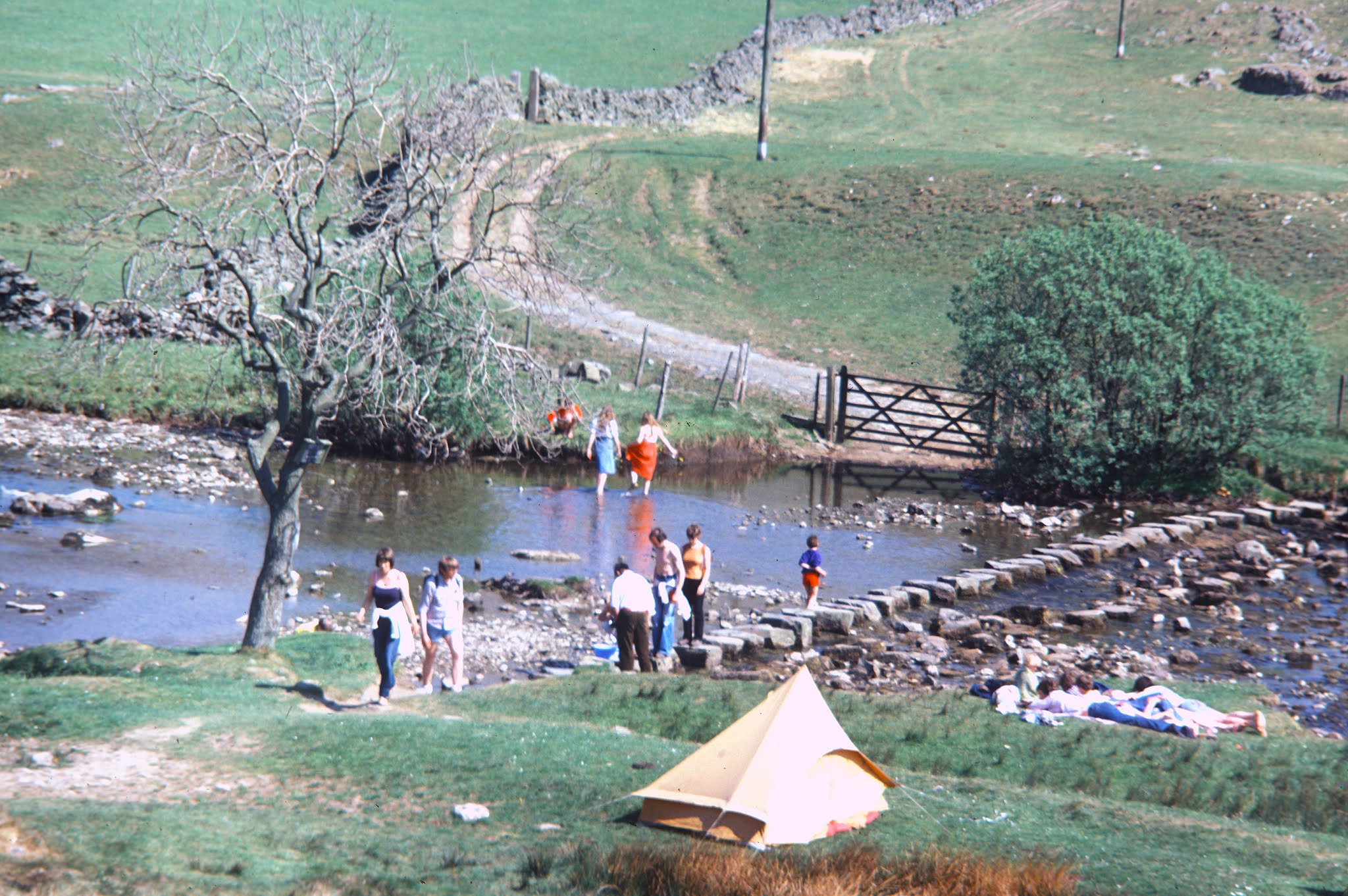
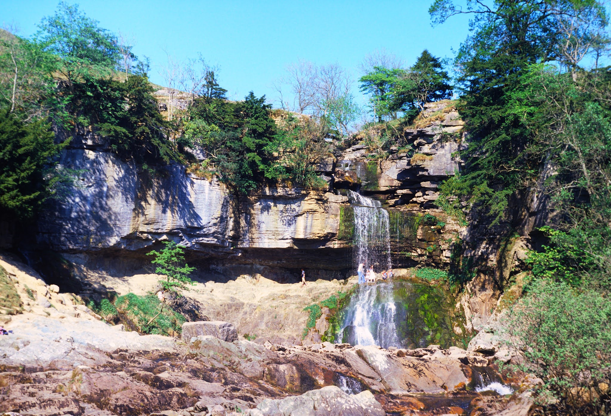
The picture above is of Beezley Falls, and the one below shows our gang crossing stepping stones near White Scar Cave.


A lone tree often provides foreground for the view towards Ingleborough, but on this occasion I appear to have substituted that with a lone cow...


Maggie, Ruaridh and Nick enjoyed a paddle en route.


We enjoyed the spray behind Thornton Force before wending our way back to Ingleton village.


The 'diary' was Nick, and he transcribed his jottings thus:


A few days later, on 24 May, some of us were admiring the Roman remains at Chollerford.

Bob and Annie were there, but the diary had been left at home.


However, the purpose of the trip - I think we stayed in Hexham for a couple of nights - was made clear from the next picture.


We haven't seen Dave and Linda for far too long, but coincidentally we plan to meet up in the Lake District in a couple of weeks time.

Whilst D and L embarked on their honeymoon, a visit to Peel Crags and Crag Lough seemed appropriate.


Then we visited Vindolanda, and went home.


'Wet Wales Weekend Wander'

On 31 May five of us - me, John, Dave, Nick and Ruaridh, set off on what was named the 'Wet Wales Weekend Wander'. Our Friday night camp at Llyn Tecwyn-Isaf certainly looks a tad damp - what a contrast to the recent Glencoe weekend!


The next picture re-emerged regularly in the 1980s. I'm sure Nick can provide an appropriate caption!


We spent Saturday bumbling about the northern Rhinogs in the rain, recorded below in five lines of diary entry. Here's Nick on a Nature Trail near Dinas.


On the Forestry Trails, this weekend's pictures are very poor, even with the help of Photoshop.


After a march across forestry land to the east of Rhinog Fawr, Dave catches up with yesterday's diary entry, as Nick is champing at the bit to get going with the entry for 1 June.


Boggy  paths led back up to the ridge.


Here's John ascending towards Clip

We reached the 1937 ft summit of Clip, admiring views towards Snowdon to the north.


Here's the view in the direction of Porthmadog.


The weather had cheered up by now, and we found a good spot for a relaxing lunch.


After that we ambled back to the car at Llyn Tecwyn-Isaf at a steadily increasing pace due to John's worries about catching his train back to Darlington. He missed it so was home very late. The rest of us adjourned to Rusholme for a curry - a very common conclusion to a weekend in those days.


Here's our diary entry. The walk seems to have been based on an article by Mark Richards in Climber and Rambler magazine - April 1979 (I can't find my copy!).


The route appears to be roughly as shown below - 19 km with 850 metres ascent on the Saturday; 17 km with 700 metres ascent on the Sunday. (Click on the image for a better version.)


Sometime in June, I must have escaped from work to take a few pictures of the Mayor's Procession. Such events were quite common back in those days, and a procession of 'floats' always passed through town, fundraising, during Rag Week. 

Times have moved on.


'Lakes and Other Water'

The next diary entry, for 14 and 15 June - the last entry in Volume 1, and the last of Nick's typing marathon of all that diary's entries, is shown below. It's not illustrated as I wasn't there, and I don't have pictures from any of the participants, one of whom remains a mystery 'Ian ?'. However, I've included it here for the benefit of the participants, who will no doubt remember it well.


'Mucky Marshy Muker March' or 'Tanhill Trundle'
Cast: 
Dave, Nick, Colin, Ruaridh, Martin

Preface:
"Don't expect anything fancy at the start of this diary - Dave did it." - N (I've edited it - Ed)

Friday
Met in Cox's Bar. Colin late, Nick and Martin early. Set off for Muker. Stopped at excellent food pub, the Boar's Head, somewhere on the way to Settle. Set up camp mainly in the dry!!!! at Muker, 308 yards west of the westside Muker signpost. Excellent sleep.

Saturday
In the morning we had a Mrs Beeton style breakfast - take 12 eggs, 1 pig, 1 loaf of bread, etc etc.
Re-packed tents in the rain. Nick and Dave demonstrating their amazing technique of packing rucksacks and tents without getting wet. Meanwhile in the other tent they had just finished washing up.
Ruaridh produced an ice axe!! Had a rucksack weighing session. Nick's was heavy, and I quote "I'm a man, I can take  it" (to laughter in the background).

Set off for Gunnerside. Got lost in Muker.

Lost in Muker

An old lady set us off on our way. On the wrong footpath. [20 items of wildlife listed.] Crossed a good bridge, 3' wide. Nick, Dave and Martin sped on to the pub in Gunnerside and therefore avoided the rain. Colin and Ruaridh lagging behind, arrived 30 minutes later, looking very wet. Excellent beer.

Sometime during the proceedings I took this picture and captioned it 'Yellowhand Ruaridh'

The River Swale near Gunnerside

Outside the pub in Gunnerside

Walked up a valley and stopped for dinner. Martin and Nick killed a rabbit. A sumptuous feast was eaten. Met some Dutch people ("You can tell by their waterproofs" - Nick).

Turned right after some old mine workings. We all declined to go down a tunnel. Came upon a Dr Who landscape with three abandoned diggers in various states of decay. [More flora and fauna listed.]

Turned left onto another moor. Then more moors. Dave zoomed off in front. Nick lagged behind. Ended up going across bumpy ground. Colin nearly got five broken ankles. Eventually arrived at Tanhill Inn, half way along the Pennine Way.

Pitched tents away from noisy generator. Colin, Ruaridh and Martin in Vango Mk4, Dave and Nick in TrampII. Had meal. Chicken, rice, onions, peppers, mushrooms, mixed herbs and grass. For the second time, Dave was not allowed to use his plate. Got all five of us into the Mk4 for dinner and a discussion on people's dirty habits, especially Colin's. [All bizarre, except for 'sleeping on roofracks - Ed]

Went to boozer.

Sunday
Woke to a cup of tea from Nick. Sun pouring into the tent. Breakfast of bacon and tomatoes. Martin showing the cool sophisticated look with his half pair of jodhpurs. Lots of inquisitive hungry sheep. Inter tent warfare involving tins being chucked at each other. Dave was allowed to use his plate for the first time. Once again Nick and Dave were ready to leave 30 minutes before the others.

Set off down groove at 10:07. Quickly got lost in the groove 3½ miles out. Regained the track but went wrong yet again. Kept on path into Keld. Met our first people of the day here. Decided that there was no pub in Keld. Turned left (east) to go down Swaledale. Stopped by river for a brew up. Martin got attacked by midges and moved uphill, followed by the other two Mk4 people. Nick and Dave, being 'men who can take it' stayed behind, whereupon the midges left and followed Martin up the hill.

Nick and Dave found the others on top. Still eating and being eaten. Nick found a map in the river at Malham Tarn. [He must have been teleported there!]

Dave [solely responsible for this trip's diary entry] walks in front, giving rise to moans from the rear of the party. It seems he can't do anything right cos when he lags behind they also moan. Life's not fair, aaargh.

Set off down valley. Slight breeze cooled us down. Ruaridh got left behind looking at wild flowers. Saw farmer rounding up sheep. Hit the road to Muker, then returned to Manchester via Colin's house and an Indian meal.

Here's a very rough guess as to the route - about 32 km, with 900 metres ascent.

Monday, 25 January 2016

A Brief Visit to a Distant City

2301party1

It was our good friend Anne’s birthday on Saturday. A church hall had been hired. Old friends would be present.

Earlier we were joined by TGO Challenger John Sheffield for our first visit to Stretford’s parkrun. It was the tenth running of that 5 km event. Our usual venue, Wythenshawe Park, has hosted 221 such events but is currently not available due to a waterlogged course. Stretford is a short, flat, fast course on a hard surface. 444 people turned up. It was crowded. There were a good number of Wythenshawe regulars in evidence, as well as John, whose home run is in Winchester. I tried to go slowly on this first visit, so as to be in a posoition to get a personal best next time. I’m not sure whether that plan worked, as my time was quick, albeit my position was well down the field. A survey of GPS owners indicated the general impression that this course is 200 metres shorter than the one at Wythenshawe, so no wonder that I finished a minute faster than I thought I was running…

Anyway, Sue and I were soon in transit to the distant city, a family visit featuring two shy budgerigars, then the big party with lots of friends.

Notable attendees were Doug and Margaret. Doug was a fine marathon runner in his day, and after his running career ended he completed the TGO Challenge on numerous occasions. He and Howard and Morpeth were most helpful to me at the end of my first Challenge in 2007, if I remember correctly. Doug uses a Phoenix Phreerunner tent just like mine. Margaret was a year ahead of me on the same degree course at UMIST. I hadn’t seen her since about 1973!

The evening was briefly punctuated by a short concert.

2303party3

The city’s graffiti seemed to have been created by a street sculptor rather than a street artist.

2405newcastle5

There are some (iconic?) buildings.

2407newcastle72401newcastle1

The area below was deserted.

2406newcastle6

Friday, 16 March 2012

March 10/11 2012 – A Rentahostel Weekend in Wooler

Embleton Bay, approaching Newton

Well, it hardly seems a week since we were setting off on this trip!

Last Friday saw about 40 sundry persons accumulating at Wooler Youth Hostel, for a weekend  in ‘sunny’ Northumberland.

The ‘Local Pub’ Arms met our little sub group’s requirements, with a good value two course offering.  Then GS’s 'pre-booked’ group of about a dozen turned up, much to the surprise of the restaurant staff, who had received a call from the ‘Local Pub’ Arms in a neighbouring village along the lines of ”Have you seen our customers?”  The answer of course was “Yes, they are eating here.”  The (other) ‘Local Pub’ Arms were not amused and are no doubt being overwhelmed by GS’s apologies for this stupendous ****-**!

With about 20 cars between us and room for only just over half of those in the car park, also used by residents of a nearby house, ‘Mayhem’ could accurately describe Saturday morning’s assembly outside the hostel.  Some left to attempt a linear hill ‘bagging’ route, whilst 19 of us assembled for a lower level outing from Wooler.

These three looked cheerful enough, as they gathered for the leaderless stroll.

Ready for a long walk?

Various maps were surreptitiously fondled as we headed off along the St Cuthbert’s Way footpath, which I’d thought was the intended route to the Iron Age fort on Humbleton Hill that I was told was our first destination.

So when everyone paused at a path junction, I strolled on along the St Cuthbert’s Way path, expecting to be followed, unaware that an intermediary destination, Coldberry Hill, had been inadvertently inserted into the plan.

Anyway, I enjoyed a potter around the remains of the fort, which possibly dates back to several hundred BC, before all 19 of us gathered for elevenses on the sheltered side of the hill on this somewhat chilly day.

"Nice tea" says Sue.
‘When’s she going to pass the shortbread?’ ponders Paul.

Sue and Paul at Humbleton Hill Fort

It was altogether Very Jolly (see slideshow – link below - for more pics of people being Very Jolly).

Further on, another 'Fort & Settlement' was visible from the summit of Gains Law (319metres), with good views back to Humbleton Hill and the dry valley to its south.

After some discussion a consensus was reached whereby we would continue to be leaderless but would follow the St Cuthbert’s Way path - a 100km (62.5 mile) long distance walking route across the Scottish Borders to the Northumberland Coast following in the footsteps of St Cuthbert - all the way to Tom Tallon’s Crag.  Here’s part of the assembly, striding out along the broad path, with the Northumberland lowlands stretching towards the coast in the background.

Striding along St Cuthbert's Way

There’s a high (815 metre) hill near here called The Cheviot.  It has a reputation for trapping the unwary in a morass of mud and bog, and on this day you could add cloud to that list, so we observed its grey flanks with some pleasure that it wasn’t on our itinerary.  Nor was it worth capturing on ‘film’ (or ‘phillm’ as they pronounce it in this far flung extremity of the UK).

All apart from Colin had attentively listened to the plan to conquer the immense boulders of Tom Tallon's Crag – at 353 metres the highest summit, if not the high point, of this walk, so whilst he hid out of the wind in some heather by a path junction, the rest of us enjoyed a break in the shelter of Tom’s two foot cliffs. It was still early, so lunch was delayed until  we had trudged along a few more little red dots to Commonburn House.  A quick dash from the vanguard ensured a nice grassy bank, out of the wind, for lunch, somewhat to the disgust of a group of youngsters heading for the same spot.  There were quite a few people about in this area. 

Some of our group chose to head directly to Broadstruther, as planned (apparently), from here, leaving about a dozen of us to enjoy a longer walk that took us first past one of several walled enclosures in the area, still completely intact, presumably used for corralling livestock.

A rough track across the moor delivered us to the edge of a wood above Goldscleugh.  Here something 'spooked' Sue W, who rushed up a tree in a bid to escape.

Spook No 1 Spook No 2

A good path led through the wood towards Goldscleugh, where the blare of a hunting horn was unmistakable as we looked down to the dilapidated farmstead to see a jolly band of hunters with their pack of hounds.  Whilst seemingly a bit ‘posher’ than our rag tag (Colin excepted, he has a big posh car) band, the hunters – who had no booty – couldn’t have been more friendly.

 A Hunter

“We were drinking and chatting whilst the boss got bogged down, the fox made a break for it and the hounds got lost” – I think that’s the gist of what she was telling us.

The route from Goldscleugh led up to a final tea break after a few dark mutterings as we negotiated our way along a ‘path’ that had once run through the trees of a now felled forest.

Eventually we reached a cottage at Broadstruther, which those on the 'short route' had passed some time earlier.  At first we thought it might be a bothy, but this place was far too smart to warrant that description.*

Broadstruther

Wide paths and sturdy bridges then ensured an easy passage back to Wooler.  Just as well, as people were starting to flag.  Some were nearly asleep.

Tired troops on the last lap to Wooler

Here’s Saturday's route - 27km, 700 metres ascent, 8 hours (subject to a short cut from point 5 to point 7 by a few people).

 Our route - 10 March 2012 - 27km, 700 metres ascent, 8 hours

Fortified by Sue’s Saturday night soup, stew and cheesecake, the assembled gathering, apart from those who had gone gone ‘sick’ (though Sue isn’t getting the blame for spreading chicken pox), managed to summon the energy needed on Sunday morning with which to consume their second ‘Ken’s Big Breakfast’ of the weekend. 

Then some folk went home, but the majority pottered over to Craster, where we set off along the well worn path towards Dunstanburgh Castle.

There were quite a few of us on this walk!

Walkers near DunstanburghDunstanburgh Castle

Embleton beach provided a sunny spot amongst rock pools for elevenses and a sunbathe or paddle for everyone except me.  I had urgent business back at Craster having left the fridge turned on.  Flat battery averted, I returned in time to join those who hadn't succumbed to the lure of their long journeys home, for the final stroll over firm sand (pictured at the head of this posting), with trees, on the approach to the fleshpots of Newton.

Trees in the sand

It was 'beer o'clock' by the time we reached the Ship Inn, from where some of us left with sunburn.

Beer o'clock in Newton

Pied Wagtails skittered across the roofs at the back of the pub.

Pied Wagtail

Toads were abundant on the walk back to Dunstanburgh above the beach.  They were piled on top of each other like little dumps of dog poo.  Care was needed.  Clumsy feet squash toads!

Dunstanburgh Castle drew ever closer, and here Sue and I said our goodbyes and went off to explore the castle (see slideshow) whilst everyone else went on their way.

Dunstanburgh Castle

Then we also went home...

Here's our route - 14km, 70 metres ascent, in all of 4 hours.
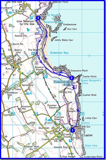
Our route - 11 April 2012 - 14km, 70 metres ascent, 4 hours

There’s a full slideshow here if anyone is interested.

Finally, here’s Ken’s ‘Bird Report’:

Saturday: Skylark, Lapwing and Curlew returned to the moors for breeding.

Sunday: Yellowhammer and Linnet, Oystercatcher and Eider at Craster; Fulmar, Razorbill and Kittiwake returned to sea-cliffs to breed. Seal basking in the bay at Craster as well.

* According to the internet, Broadstruther was “a totally derelict farm, the main building had no roof and the walls were in a state of collapse. On completion the new building will be used as a luncheon facility for shooters on the Lilburn Estate.”