Sue and Martin in Mallorca 2019

Sue and Martin in Mallorca 2019
On the Archduke's Path in Mallorca

Friday 29 July 2022

Friday = Isabella Day (16)


No 'park pictures' from me today, as I was otherwise occupied at the dentist and elsewhere while Sue took Isabella out. Sue took this flower picture, but none of Izzie.


After a tasty lunch of lasagne, satsuma, banana and yogurt, the youngster settled down for a long nap. She awoke to the presence of an auntie and two cousins.


Llama has apparently replaced 'Baa', who was apparently recently evicted from a pram.


The cousins built an impressive railway, whilst Isabella hugged a fire truck.


"Smile everyone!" Can you see who is practising at being a teenager?


Isabella soon got into the swing of things, as she embraced the role of the Fat Controller.


And before we knew it, it was time to go home.


It was another lovely day with Izzie, plus Heather in the morning and Kate, Jacob and Jessica in the afternoon.

Thursday 28 July 2022

November 2004 - The Annapurna Circuit - Day 19


Friday 19 November
Beni to Pokhara

Itinerary: DAY 19 Drive to Pokhara (900m) We take a short walk to cross the Kali Gandaki River and drive to Pokhara, a lively town beside Phewa Lake situated at the foot of the Annapurna Range. Upon arriving at the hotel we say good bye to our trek crew. In the afternoon you can wander around the lakeside, take a boat ride or just relax. (4 - 5 hours drive depending on road conditions). Overnight Shangri-La Village Resort on bed and breakfast.

[Diarist: Martin]
Last tea call of the trip at 6 am - hot water follows shortly after. 

Porridge and omelette for breakfast, then a leisurely time before we strolled for 15 minutes through Beni, across the bridge to a 'traffic zone'. Good views up the Kaligandaki to mountains. 

A bus had been hired and all kit, etc and crew were being installed. They all got off for a group photo, then we embarked on the road to Pokhara. The driver of the Tata bus was careful and the first hour along dirt roads wasn't scary despite views of the gorge, far below under unprotected drops from the track.

The bus to Pokhara

A street in Beni

End of Trek Group Photos

Then we joined a tarmac road at Baglung. 8:45 start from Beni to ~11am pee stop, then a photo stop for views of Annapurna 1 and Machhapuchhare from an 1800 metre pass high up near Khare. Then we gradually descended into the more populated area around Pokhara. There had been superb views down the Kaligandiki until we left it at Kusma, and there were increasing amounts of cultivated terraces, rising high up the mountainsides.

The Annapurnas and Machhapuchhere from the road to Pokhara

Fishtail (Machhapuchhere) from the road to Pokhara

We passed through various police/army checkpoints and later discovered that someone was murdered today in Pokhara. (Probably people were also murdered in Manchester and London, but not high-ranking officials, as here.) 

So by 1 pm we had arrived at Shangri-La Village Hotel**** to the south of Pokhara, and were soon installed in rooms with a bit more character than those of the Radisson in Kathmandu. It was a hard goodbye to Mahesh and Deepak, and Hosta and Nebraj - and finally a friendly wave to/from the rest of the crew, who are continuing on the bus back to Sanjeev's house in Kathmandu, their next task being to clean, mend, maintain, etc, all the equipment taken. Quite a task. 

Andrew, Mark and Sanjeev stayed at the hotel for lunch whilst the rest of us took a taxi to Boomerang restaurant at Lakeside, where we enjoyed a leisurely lunch in the shade and watched boaters on the lake, and women washing clothes, beyond the restaurant's green lawns. 

Unfortunately it was quite hazy so there were only occasional brief glimpses of the high mountains beyond the nearby wooded hills. 

We walked back to the hotel (half an hour) partly beside a canal, passing Lakeside stores selling clothing, books, etc, and men offering me a shave. We bought a poster and a cookbook. 

Then a few hours' R&R before meeting with Sanjeev for a good buffet meal at the hotel. By 10 pm we were all (except maybe Sanjeev) ready for bed and we adjourned for a good night's sleep in real beds.

Next Day
Previous Day
Index

Wednesday 27 July 2022

Summer in De Quincey Park


Not much walking at present, just a few 5km strolls from home - I'm up to (not)parkrun number 700, so that's 3500 km in the last couple of years. It's always a pleasure to pass through de Quincey Park on these little outings.


Tuesday 26 July 2022

November 2004 - The Annapurna Circuit - Day 18


Thursday 18 November
Tatopani to
Beni

Itinerary: DAY 18 Beni (823m) Leaving Tatopani we cross the Kali Gandaki to its east bank and a little further we cross the Gaar Khola to rejoin the Kali Gandaki. We continue south on the east bank of the river on a trail, which in places is carved into the rock cliff. After passing through sub-tropical forest we cross the river again to its west bank at Tiplyan (1,037m). We pass Ranipauwa (1,189m) and cross the Rahughat Khola to reach Beni, the administrative centre of Myagdi District at the confluence of the Myagdi and Kali Gandaki rivers. (7 - 8 hours walk). 

[Diarist: Sue]
Last day on the circuit. Usual 6 am start. The morning is hazy but warm enough to get dressed in shorts. No down jackets to be seen this morning! 

On sitting down to breakfast, Andrew got a shock when checking the contents of the cornflakes packet. A large grasshopper stared out at him! It was shaken free of the packet, but with a leg missing, which we presumed was in with the cornflakes. Someone made the witty comment about the novelty of free gifts in cereals these days! Suffice to say, nobody ate any. 

We were off at 7:30, on a fairly long day for our last one. The path was fairly wide and in places was hewn into the hillside above the river. In several places, steps were cut into the rock in the narrow gorges. The vegetation was lush, with orange trees, bamboo, a few rice fields being harvested, and banana palms. Small settlements were frequent. 

Despite the route being generally downhill, there seemed to be quite a lot of ascent. The true 
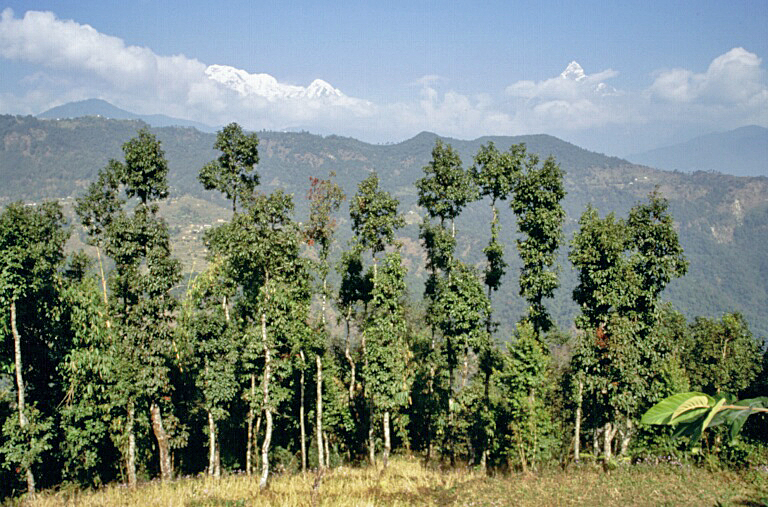
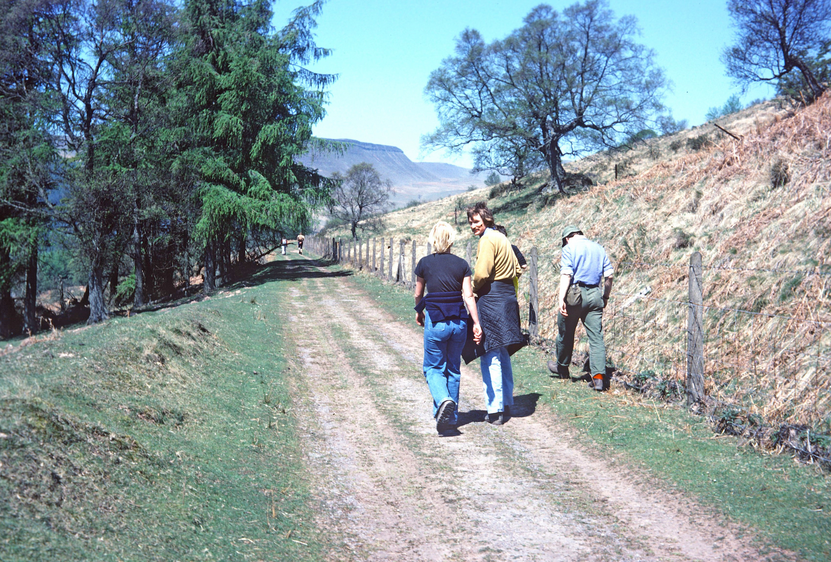
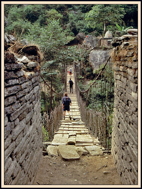
circuit goes to Ghorepani, and at the first junction below Tatopani, (by the bridge shown above) another trail led upwards in that direction. The river was crossed by suspension bridges several times. There were numerous mules that caused us to stop so that they could pass. In one area, the path was cut into the hillside, and men with enormous packs had to bend right down to get through. Drips fell from above, and these men were barefoot in the mud and stone.

Patterns of cut rice

A village beside the Kaligandaki

Blue flower, perhaps Barleria cristata
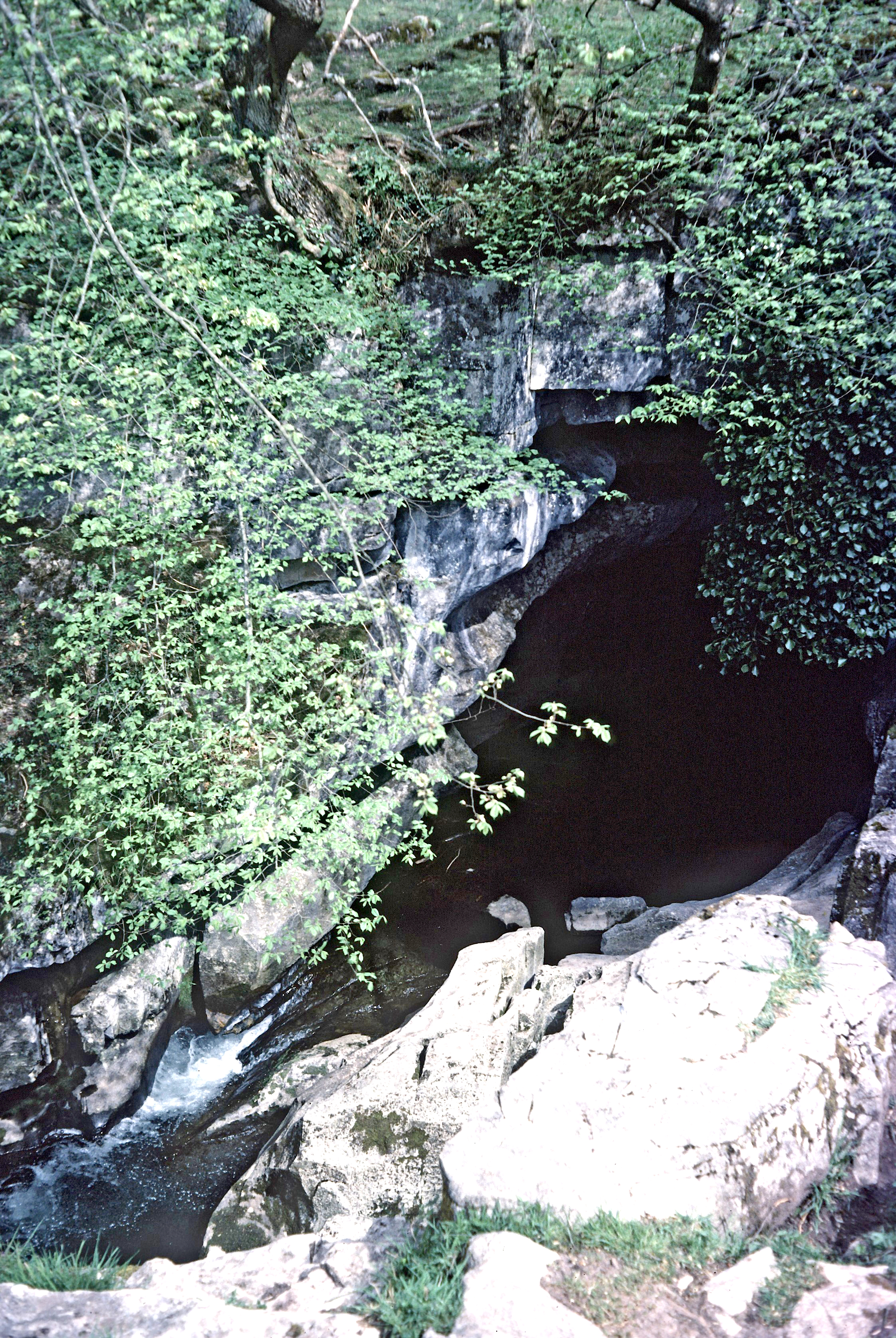
The steep hillsides produced some fine waterfalls, often long ribbons of water. A lemon tea stop was welcome - it wasn't too sunny but was quite humid. Energy levels were restored with crystallized ginger mountain mix and jelly babies.

The trail was wide enough for a couple of jeeps to plough up and down between villages as a bus service. Apart from motorbikes and tractors these are the first vehicles seen in a couple of weeks.

Another pleasant lunch, during which the local small kids played with our trekking poles and got to look at their pictures on the back of Mark's digital camera. We munched on chips, spinach, cheese chapatis, pumpkin fritters and sausages, and a fresh orange. During lunch, a tractor and trailer drove past, amusingly with our porters and loads on board! 

We descended further after lunch, soon stopping for more lemon tea after a river crossing guarded in several places by the army, with guns. Apparently a meeting was going on in town. Our kitchen crew came past here. Whilst Deepak was on the bridge a mule raced up behind him, only raising a smirk from the very shy cook. 

Toyota Corollas were parked at the end of the village, and on the last stretch to Beni these threw up dust and fumes occasionally. Black kites soared above the river.

Yellow flower

Crossing the final bridge above Beni

The last 'hiking' picture
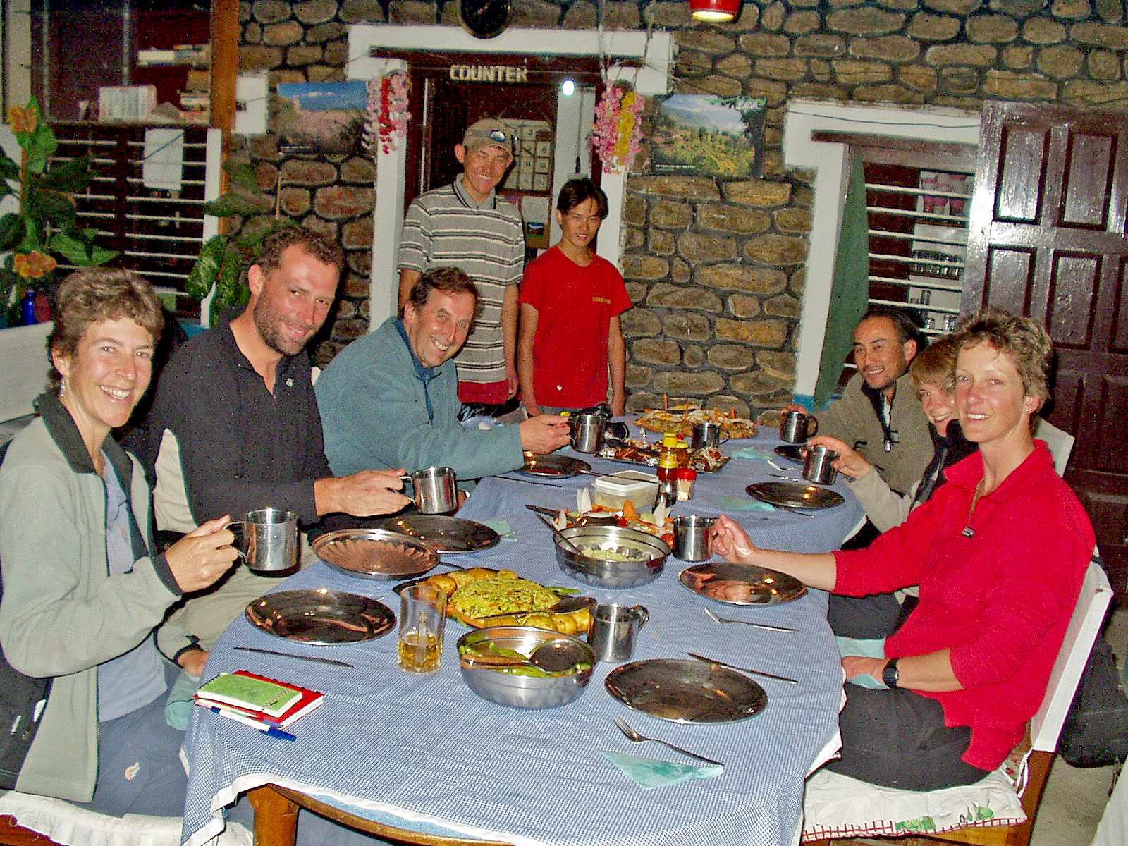
The trek ended at the Yeti Hotel, where we waited for a while in the garden whilst rooms were sorted. Couples have attached bathrooms, but singles must use a communal bathroom. Rooms, ours on the top floor, are basic but fine. 

Washing water is really hot, then we have tea downstairs and play Uno until dinner. As it is the last night, a 'feast' is prepared. It's soup and poppadoms, then crispy noodles and fried eggs, chicken, salad, rice, roast potatoes, beans and cauliflower. A chocolate cake, iced 'Happy Trek End', was a good pudding, with the remainder shared amongst the crew. Mugs of rum punch were served from the large kettle. 

After dinner, the whole crew assembled around the dining room. We'd contributed 5000 rupees (~£40) each for their tip, and these had been distributed into the following envelopes:

Mahesh (Sirdar)
Sherpas - Hosta and Navraj
Deepak (Cook)
Kitchen staff (x4)
Nike and Surya
Porters (19)

Further distribution occurs amongst themselves. Each of us made a presentation of an envelope to one of these people. Andrew made a short 'speech' to the effect that usually he loses weight on these trips, but with Deepak's excellent cooking this was the first time he had not done so! 

From a bucket, the porters were served Rakshi in tall glasses. Until 10:45 pm, most people danced, including our one-eyed table man, who looked as if he was enjoying things immensely. Only Deepak refused to dance! Sagar proved a very graceful dancer. We did not have the chance to sing 'On Ilkley Moor' that Lindy had written out. We retired much later than normal, but with the usual 6 am start in prospect. 

Today's route was pretty much 'Nepali Flat' - Sanjeev's description of a gently undulating path. 

Statistics:
Start: 1350 metres
Ascent: 50 metres
Descent: -395 metres
Finish: 1005 metres
Time: 8.6 hours
Stops: 2.6 hours
Walking time: 6 hours

Next Day
Previous Day
Index

Monday 25 July 2022

May 1977 - A High Street circuit, the Brecon Beacons, and Runswick Bay


14 May 1977 - and I'm following Pete Morley up the Garburn Road in the Lake District, with the summits of High Street ahead. I'll continue by way of captions, as I've found no diary for this period. If you click on a picture you might find a slideshow of better images, but the captions won't appear.

It looks as if this trip's participants were Pete Morley, Dave Scruby, Gary Beighton, Roger Freeman and myself.

This backpacking route from either Troutbeck or Kentmere took us to the summit of Yoke (706m), where we rested on a fine day.
My old red Karrimor Tote-em Senior can be seen - fairly new at the time.

There was a good view back along the length of Windermere.

Roger posed for this photo, looking north, on the top of  Ill Bell (757m),
as we continued along the High Street ridge.

Pete is pictured here on Thornthwaite Crag, looking back down the ridge.

Our high level camp, circa 700 metres, was near The Knott (739m). I suspect that Frank Brierley's Karrimor wedge tent was borrowed by Gary Beighton for this trip, and it was fastened to my green wedge (still available for use in 2022) to give us both a nice enclosed porch.

The day ended with a stroll to the summit of The Knott at sunset.

The following morning, we headed back over High Street and descended to Blea Water.

Then we descended to Haweswater Reservoir, not the most direct route to Pooley Bridge!

My final snap from that trip shows one of our (heavily laden) number on the descent to Pooley Bridge, where perhaps we had left a car in which we squeezed in tightly, that would return us to another car from where we started the walk.

If anyone has a better memory than me of this trip, I shall be pleased to insert it here....

The following weekend, 21 and 22 May 1977, a few of us met up in the Brecon Beacons, basing ourselves at Ystradfelte and maybe meeting up with Martin Elliot's Cragrats (though they do not appear in the photos, so that may have been a different trip).

This cave at Ystradfelte is possibly the one into which we used to enjoy crawling quite a long way.

We visited waterfalls on the Afon Mellte, on the beautiful 'Waterfall Walk'.

John Mansell (RIP) joined me on this trip, and we met up with Christine Cartledge, who was on the same course (biochemistry) as me at UMIST, and her Australian boyfriend, Richard.
Bob Selig was also there, but I have failed to scan any photos in which he might appear.


The following day appears to feature blue skies.
The above picture was taken on the Roman Road by Tor Glas.

We clearly enjoyed a walk in the Brecon Beacons, finishing up with a splendid view (below) to the north, with the Roman road conspicuous in the washed out (maybe it was hazy, maybe the camera, or its operator, couldn't cope!) scene.


The next weekend, on 29 May 1977, a group of us descended on Runswick Bay.


I can identify John Clark and Laurie Marshall (RIP), who are also the dam builders pictured below, but the three looking away from the camera remain a mystery. Perhaps Bob Selig, Don Waye, and someone with a football that matches his jumper...?


And that was May 1977 - without these pictures it would be an even woollier memory.

Sunday 24 July 2022

November 2004 - The Annapurna Circuit - Day 17


Wednesday 17 November
Lete to Tatopani
Itinerary: DAY 17 Tatopani (1,189m) Crossing Lete Khola on a suspension bridge we follow the valley through pine forest down to Ghasa (2,013m) where we cross the Kali Gandaki and descend along the east bank. Descending further south we again cross the same river before reaching a huge waterfall at Rupse Chhahara (1,631m). By now we have descended almost 4000m since the Thorung Pass and start to feel the warmth of the sub-tropical surroundings. We descend further passing a Magar village of Dana (1,446m) to reach Tatopani, famous for its natural hot springs. (6 - 7 hours walk).

[Diarist: Martin]
Usual 6 am tea. The nights are drawing in so it is now still dark at 6 am. But by the time washing water arrives a few minutes later it's light enough to wash and to pack our duffel bags and day sacs for the day ahead.

A view to Dhaulagiri and Tukuche Peak from below our camp at Lete

For the first time for ages there is no frost, so last night was probably the last for the winter sleeping bags on this trip. There is a view of Annapurna 1 high above. It's clear now, but high cloud is already forming and will soon come in to dominate the day. Low cloud will also swirl around, preventing Twin Otter flights to Jomson from Pokhara. We do see some helicopters and wonder whether the trekkers in trouble on the Dhaulagiri Circuit have been got out safely. 

An indoor breakfast of porridge and omelette - in the tea house with pollarded trees that we camped outside - preceded a 7:40 am start. Suria led us away - he has been invisible to date, leading the porters to the correct place. We started across a long bridge with poorly tensioned cables, so the handrail flopped to the side and would not be available unless one fell over.

A typical village entrance

Marching down the valley

The path is busy today with trains of ponies, the pantechnicons of the path, carrying cement and building materials and provisions up the valley and perhaps to as far as Higher Mustang, but not as far as Tibet. We descend into a warm fertile climate and soon reach Ghasa, where tomato like fruits - red and green - dangle from shrubs. They are used for making pickle. We pass vegetable gardens, still seeing occasional chortens (pass to the left).

Bark roofed houses

Crossing a wooden bridge

Looking back up the valley

Lead mule in headdress

Cherry trees are in blossom here. We see the sun at 9 am, fleeces come off, there is a huge waterfall up to the right. Views (glimpses) of high peaks through the cloud. Luxuriant cabbages, nicely paved path (motorway), poinsettia and marigolds line the track, and the noisy buzz of Cicadas and the rush of the river below, make it a less than quiet section. 

11:00 to 11:30 - tea at Kopchepani - and we now have left Lower Mustang and entered the Myagdi district - we had sped through the police checkpoint in Ghasa.

Police post below Ghasa

The bridge below Ghasa

Lunch is taken at Rockland - in sight of the waterfall at Chhahara - 12:00 to 1:40 - an excellent lunch - we watched Deepak make cinnamon rolls. 

We set off past the ubiquitous sleeping dogs, passing huge rocks and a big slab of a rock face. The vegetation changes as we pass through areas of bamboo, oranges, sugar cane, aloes, bananas etc.


Descending to the 'tropics'

Cherry blossom

 A Himalayan flower

Old men by the path side are flattening, seeding and ploughing the land, using ancient tools, buffalo and a lot of strength. We rest by a huge bouganvillia tree. Past a hydro plant capturing the energy of water coming off Annapurna. There is a giant 'pudding stone' rock to the right - it looks a bit looser than the Pyrenean variety.

Ploughing below Dana

A typical metal bridge

View towards Tatopani camp

There are many people ascending today, few seen going down. Well swept stone paths through villages. Eventually at 4 pm we arrive in the nice village of Tatopani, after seeing our tents from some distance away. Unfortunately it's a cloudy afternoon, so there are no significant high mountain views. Hot water arrives at 4:30, then tea and biscuits are taken in the dining tent at 5pm.

On the Tatopani campsite, with poinsettia


Waiting for tea

After that we enjoy the highlight of the day - a trip to the nearby hot springs. These are five minutes away, by the river. Two small pools of hot water - in which we luxuriate for about half an hour after washing ourselves in a separate outflow first. Dusk fell as we enjoyed our dip. We enjoyed a beer before leaving (Mark had two as he resisted the temptation of the hot springs due to his crumbling hands). 

And so, to another nice meal - vegetarian - pasta and additions, potato cake, pumpkin, pizza etc, preceded by delicious pumpkin soup. Hot custard for dessert. 

Dinner is served

Then we headed downtown and found a bar which promptly emptied then closed, so we took the rest of our beer back to the dining tent, evicted some porters who were just about to go to sleep in it, and downed the rest of the beer whilst enjoying a game of knockout whist (Mark won). 

9pm bedtime. 

Statistics:
Start: 2390 metres
Ascent: 55 metres
Descent: -1095 metres
Finish: 1350 metres
Time: 8.5 hours
Stops: 2.5 hours
Walking time: 6 hours

Next Day
Previous Day
Index