Hello, I am up to date with postings, some of which have been resent. They are getting the Blackberry tick, but they aren't getting through to the blog. I'm getting the following email from Google's 'Mail Delivery Subsystem':
"This is an automatically generated Delivery Status Notification
THIS IS A WARNING MESSAGE ONLY.
YOU DO NOT NEED TO RESEND YOUR MESSAGE.
Delivery to the following recipient has been delayed:
'Postcard from Timperley'
Message will be retried for 2 more day(s)"
So this is an experiment to see whether the posting works. If it does I will resend the rejected postings, so they may appear several times. Sorry for that if it happens.
Martin
Sent using BlackBerry® from Orange
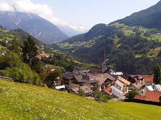
Sue and Martin in Mallorca 2019

On the Archduke's Path in Mallorca
Saturday, 28 July 2012
Friday, 27 July 2012
On Holiday in the Lechtaler Alpen - Day 2 Württemberger Haus (2220m) to Hanauer Hütte (1920m)


We woke after a good sleep amongst folk who understand the etiquette of life in a mountain hut. Breakfast was provided on a plate so large that we could each make a ham, cheese and jam sandwich for lunch out of what we couldn't eat.
By 8.15 we were ready to go, after friendly exchanges with others who had spent the night at the hut. Brigitt and Marieke were taking the sporting 631 route to Madau, whilst Alex and Konrad were heading down the scenic descent to Zams. Work loomed for them all.
Nobody else appeared to be heading in our direction. We were continuing along the magnificent path 601, which also doubles as the European E4 route, which doesn't seem to be as popular as E5. A rising path with fine views back to the hut and yesterday's descent route (pictured), led to some steep ground over which we knew some children had arrived yesterday. Nevertheless, this path was not for wimps! By nine-o'clock we'd risen 250 metres to Gebäud-Jochl and were in admiration of those children, who probably managed the loose scree above vertiginous drops better than I did. It was a lovely calm, sunny summer's day, though, and I enjoyed the challenge. Sue of course romped it.
Beyond the jochl, from where Steinseehütte was visible in the distance, a lovely contouring path led past snow finches and marmots, with myriads of gentians, orchids and a whole range of other alpine flowers, providing bright splashes of colour to complement the fine rock scenery.
We spotted someone behind us. A man with a staff. He passed, and we followed him up to the next 'col', 2400 metre Roßkarscharte, again over some vaguely technical ground, aided in places by steel wires.
After the breathtakingly steep climb we were rewarded with breathtakingly wide views to the eastern Lechtal peaks and Steinseehütte a few hundred metres below us.
By now we had made a new friend - Heiko, from Cologne - on holiday here, wandering the hills for a few days before taking his elderly parents home. He is of course pictured with Sue on Roßkarscharte, in one of several images gained during exchanges of cameras in this scenic spot.
Whilst Heiko went on ahead, we took our time to enjoy the belvedere to Steinseehütte, via a vertiginous passage through a narrow band of rock, which we eventually reached at 11.45. Schiwassers (raspberry flavoured water) in the sun provided the perfect rehydration fluid.
We lingered a while. After all, we were on holiday, the weather was perfect, and a pretty yellow signpost informed us that today's destination was only two and a half hours away.
Eventually we left Heiko to dry his washing and after looking back to our route down from the narrow band of rock (pictured - we arrived via the lowest point on the horizon) we headed off past fine looking Haflingers to cross into a valley to the north, via what is now known as Vord. Dremelscharte. (My old map says 'Westl Dremelscharte.)
After climbing about 250 metres we stopped for lunch - the butties made a welcome change from tuna salad. Steinsee glittered in the sun below us, with a fine mountain backdrop.
Then it was a steep ascent to the scharte, aided for the final 100 metres of ascent by the longest wire of the trip. I hauled myself up whilst Sue tried to use the rocks, some of which she sent in my direction. It was very loose, but not difficult. The top revealed yet more vistas, and a couple descending from a side route that's not on my map. We saw virtually nobody other than them and Heiko and a couple ascending Roßkarscharte today.
Hanauer Hütte lay in bright sunlight over 500 metres below us, thankfully over easy ground, Dolomitic in character. We spent the final hour of the day's walk descending to the jingle of cow bells, with black redstarts being agitated by gliding ravens.
Reaching Hanauer Hütte at 2.45, we really needed to wash ourselves and our clothes, the limited opportunities for such formalities having been ignored since leaving Zams three days ago. There was some puzzlement when we said we had booked, but production of an email seemed to help matters. We were allocated to room number 6, which we hoped wouldn't be a camp bed in the winter room.
Beer and tea respectively were needed to fuel us for the chores. Others arrived and disappeared to claim their beds, so we did the same. I couldn't really believe my eyes when I opened the door to room 6. Bunk beds (2), a sink with hot and cold water, a power point! Sadly no en-suite, but what could we expect for €11 each! Absolutely brilliant - this 1896 hut has been superbly refurbished and has moved well into the 21st century. We even got chicken for dinner.
Comments:
Alan R - thanks for the HTC offer but I plan to stay with the Orange devil I know. My contract has expired so I can renegotiate. Samsung is the current favourite.
And you know very well from your huge number of followers that many people value your postings on gear etc!
Data:
26 July 2012
10km in 6.5 hours with 1000m ascent
Flower of the Day - Alpine Butterwort
Itinerary - http://www.topwalks.com/E5%20Route.html
Sent using BlackBerry® from Orange
Thursday, 26 July 2012
On Holiday in the Lechtaler Alpen - Day 1 Memmingerhütte (2242m) to Württemberger Haus (2220m)


Manuel told us the hut gets 9000 visitors in the three and a half month summer season, of which he reckons about 100 are English.
We set off after the E5 throngs, with just Andi and two girls behind us. Soon we were pausing to admire a herd of ibex whose passage across the path had been thwarted by the E5 hordes. We were going back up to the narrow defile of Seescharte, from where we had descended in yesterday's lovely afternoon weather. Today, low cloud blighted the view, though the weather was clearer to the east of the pass.
Here we encountered Jason, a New Zealander who had been staying at Memmingerhütte. Hello Jason, do feel free to contact us for trip advice.
We soon turned off for Württemberger Haus along path 601. It was signposted as 2.5 hours away, but it took us three hours. This was old ground for me. Re-reading our diary from 18 July 1980 may be interesting!
Today's conditions, despite the cloud, which remained above us, were fairly benign. First a lovely belvedere path across a huge scree slope, then some easy scrambling (walking poles stashed) to a col and a minor summit at around 2600 metres on the Großberg ridge. Sue is pictured near here with the contouring path just visible high above her head.
The route continued over a knife edge ridge reminiscent of Snowdon's Crib Goch. Quite exposed at times but never particularly difficult, albeit the most 'technical' section of our trip to date, and aided with fixed wires at one point. Eventually a second summit with a small cross was reached, from near where we could look back to the first summit and watch the two girls happily celebrate their safe arrival there.
Continuing towards Württemberger Haus over more of the same, we took a turn to the left along another knife edge before descending over easy ground before a trickier rock band, then across some steep snow before the gentle 'run in' to the hut on another lovely route across scree.
Something of a nuisance was the light rain that started when we were half way down the rock band and not in a position to don waterproofs. Never mind, we soon got them on, the rain stopped, and by the time we had interrupted a flock of snow finches and reached the hut at 1pm we were pretty much dry again. The two girls, Marieke and Brigitt, from Eindhoven, arrived soon afterwards.
Since then we've been ensconced in the hut, watching some less than pleasant weather outside, on what was supposed to be the best day of the week.
During this time a historical foray revealed the entry in the 1980 visitors book (extract pictured, I have an image of the whole page) that confirms that together with Nick, David (he really didn't have a fixed abode in those days), Ruaridh and Colin, I was in the first group to make it over to Memmingerhütte in 1980, as late as 18 July, and so far as I can remember it was a bit snowier then. I seem to recall Rudolf, from Vienna, giving up because he couldn't find the red marks on the rocks that indicate the route. It was our first visit to the Alps; red marks meant little to us. Having covered the same ground today it seems miraculous that we managed it. It must have been terrifying, though I don't recall it as such. We did after all have ice axes. And massive loads. A bit like the couple with the dog that were amongst the eleven people we met on the path today.
How do you remember it, Nick?
Alex and Konrad, from Memminger (the town, not the hut) joined us and B+M for the afternoon and evening. Happily, the common language is English. Thanks for that, everyone.
The bottom image shows Sue with today's friends - from L to R, Konrad, Alex, Sue, Brigitt and Marieke.
All in all a memorable and nostalgic day in the mountains.
Comments:
Jules - thanks, weather is now lovely again and the huttes are fine, actually.
Alan R - you'll be interested to hear that the Saucony Hattoris have become objects of desire!
Data:
25 July 2012
7km in 4.5 hours with 650m ascent
Rain whilst walking to date: 4 hours
Flower of the Day - Round-leaved Pennycress
Itinerary - http://www.topwalks.com/E5%20Route.html
Sent using BlackBerry® from Orange
Wednesday, 25 July 2012
E5 in reverse - Day 20 - Zams (775m) to Memmingerhütte (2242m)


We enjoyed a leisurely start to a hard day. Breakfast at 8am, a quick supermarket visit, and we were on our way, under blue skies, in shorts and t-shirts.
The only flat section of today's walk was on the other side of the Inn river after crossing the motorway. Soon we were climbing and dripping, on the path that skirted the cliff where someone was already climbing, high on the rocks above us.
Beyond a memorial to Alois Bogner (5/11/1862), red and dark red helleborines lined the path, which dipped in and out of the shade of pines, past lizards and backpackers. The path was exposed, high on the walls of Zammer Loch, a narrow ravine where far below the river cut through. (Apparently 'loch' means 'hole' in these parts.)
Surefootedness was required due to the long drops to our left. The trees clinging to the steep sides wouldn't have broken a fall.
Eventually the path entered less precipitous woodland and we reached a wide green pasture, with tall purple monkshood. Haflinger horses were grazing, and a small cabin shortly before the side path to Württemberger Haus was serving drinks and luxurious plates of food. We'd met a group of 26 leaving the cabin but by the time we arrived another group of 20 had taken all the tables.
But huge glasses of Apfelschorle were produced quickly for us. In view of the heat, it was most welcome.
A huge number of people were met on today's route. E5 starters from Oberstdorf on Sunday. Soon after leaving the cabin we met another large group, this time with large dogs - what was going on? During the course of the day we must have met over 200 people. Another couple were going in our direction.
Beyond the burning heat outside the cabin, rickety wooden bridges crossed the river a couple of times, and the gradient for a while, on a path bordered with round-leaved wintergreens, was less steep.
Lunch was a quick tuna salad and chocolate in the shade of some pines. The path followed the river as the trees turned to shrubs and the views in this high valley became more impressive. Just before the gradient steepened again, a yellow bears-ear primrose shone out from below a bush, and pink primroses grew nearby. From here the going was steep and hot, but the flowers were an excellent distraction. From the alpenrose zone there were zones of other flowers - kidney vetch, the yellow primrose, trumpet gentians, then alpine pennycress, purple pansies, rock jasmine and snowbells as we neared the top of the pass, Seescharte, at 2599 metres. It was a narrow cleft, with a new and beautiful view (pictured), down to some small lakes and the Memmingerhütte, with a fine mountain backdrop.
The descent to the hut was steep and narrow, particularly next to a stream, and the final flat stretch across a green meadow and past a small lake was a relief.
Memmingerhütte has about 140 beds, and it was very busy. Manuel spoke good English and showed us two our sleeping place - two 'overflow' mattresses on the floor in the large matratzenlager, but separate to everyone else. It was strange but it worked well.
Others were less fortunate - camp beds in the winter room, mattresses in the basement, etc. Nobody is turned away.
Rehydration was achieved with a litre of teewasser.
The evening was sociable but also strange. The dining room was full, so we sat outside, but grey clouds were building and it began to rain. We managed our soup, and part of our goulasch, spätzle and salad, before thunder and lightning and heavy rain started. This was unfortunate as there was no room for us in the hut. We adjourned to the porch, where we finished our meals on our knees, much to the amusement of others.
When the rain turned to hail the porch was bombarded, so we moved further inside, where our dessert eventually caught up with us. It was washed down with beer, whilst in conversation with new friends from Holland, Edwin and Gertjan (pictured). They were camping nearby and had been walking some interesting paths.
With folk heading to bed around 9pm, we were able to sit at a table for a while before adjourning to our mattresses in time for lights out at 10pm.
Comments:
Alan R - so what should the replacement be? HTC? Samsung? Nokia? i?
Gayle - thanks for your sympathy. I'm still struggling with the space bar but have improved my technique!
Data:
24 July 2012
13km in 7 hours with 1850m ascent
Flower of the Day - Bears-ear Primrose
Itinerary - http://www.topwalks.com/E5%20Route.html
Sent using BlackBerry® from Orange
E5 in reverse - Day 19 - Braunschweiger Hütte to Zams - the reconstructed text

Braunschweiger Hütte, reached via a steep pull past whistling marmots, attentive black redstarts and bright yellow dwarf eyebright, followed by a slithery descent in mist, had hardly been visible the previous night.
Now it was a glorious morning, and in the manner of such places we had breakfasted - basic but adequate, with the lowest score to date - and were 'on the road' again by 7.15am, leaving the 'alpinistes' to their training and peak bagging.
Braunschweiger Hütte - a large, impersonal place, full of groups on Alpine training courses. But curiously not an ice axe or crampon in sight. We got chatting to a friendly German family who were on E5 with their children, but sadly it was a very brief encounter as we were soon moved to the other side of the room. Our companions for the evening there were an elderly German mountain guide and his two clients. We had little in common.
English voices. Sue investigates. A group from Cambridge on an Alpine skills course. Their rope work homework arrives. Sue leaves them to it.
Two toilets for each sex, in a nicely refurbished hut accommodating 120. Adequate supplies of food, but they had run out of toilet paper.
Our first hazard (apart from the toilets) was black ice, not a problem for us, but those ascending to Pitztaler Jöchl would need to be very careful. It was a lovely descent, with fine views across the cloudy valley to the Kaunergrat. A clucking ring ouzel followed us for part of the way. The route led over unnecessary stemples and past the foot of a waterfall, to a seilbahn used by the hütte to transport supplies, and by alpinistes and E5ers to transport their bags.
Down at Mittelberg, lorries were delivering gondolas for a new cableway. This explained why a road had been driven through a glacier below the Braunschweiger Hütte. Perhaps the Upper Pitztal is being developed for skiers, no doubt with mechanised links to the Ötztal ski areas.
Talking of mechanised links, the E5 route marked on our strip map shows it running down the road from Mittelberg to Wenns with a bus next to it. We caught the 9am bus and enjoyed a 50 minute ride, 750 metres down the valley. Had my research been better, we could have chosen an alternative high level route via Kaunergrathütte, Verpeilhütte and Piller, picking up the normal route three or four days later at Galflunhütte on the way to Zams.
After struggling to find Wenns' enclave of coffee shops recommended by Gillian, we were pointed by a local to 'the only one' - Pitztaler Hof. I'm sure there must be more!
Refreshed, and re-supplied, we set off up some easily rising tracks, tarmaced for a while, with fine views back to Wenns and the lower Ötztal. Black redstarts and pied flycatchers watched as we admired the mountain views beyond the flower laden hutted meadows (pictured).
Lunch was taken just below Larcheralm, then we enjoyed coke and cake at Galflunhütte before heading through marshy ground with bistort and cotton grass.
A thrutchy but brief ascent then deposited us, a good 1500 metres above Wenns, on the summit of Glanderspitz (2512m), on the Venet ridge. The going was much like an English Lake District ridge, but the views were massive. High mountains in a 360 degree sweep, beyond deep valleys over 2000 metres below us.
We signed the visitors book and discovered that the Cambridge pair, Adam and Jane, had passed through just five days earlier, on that wonderfully clear day when we crossed into Austria.
Reluctantly, we headed along the ridge and slowly down to the Krahberg cable-car, which whisked us 1450 metres down to Zams for no charge. This is the E5 route marked on our map and is our last planned mechanical aid of the trip apart from some ferrying around Dornbirn and the journey home.
The 'phone's GPS soon located Haus Kurz, where Rosemarie provided a good value B&B.
We enjoyed an excellent meal at Post Gasthof Gemse, built in 1726 but latterly home to the Haueis family. Hermann's proudly displayed awards relating to Haflinger horses date from 1927 to 1992.
The day closed with pleasant valley vistas on a perfectly calm and clear evening.
Sent using BlackBerry® from Orange
Tuesday, 24 July 2012
E5 in reverse - Day 19 - Braunschweiger Hütte (2759m) to Zams (775m)


In the meantime, here are the pictures:
Top - descending from Braunschweiger Hütte
Middle - above Wenns
Bottom - on the Venet ridge
It was another great day in perfect weather.
Comments:
JJ - we hope you enjoyed your walk.
Data:
23 July 2012
18km in 8.5 hours with 1650m ascent, plus a 50 minute bus ride and a 10 minute cable-car ride
Flower of the Day - Frog Orchid
Itinerary - http://www.topwalks.com/E5%20Route.html
Sent using BlackBerry® from Orange
Sunday, 22 July 2012
E5 in reverse - Day 18 - Sölden (1500m) to Braunschweiger Hütte (2759m)


There was no hurry, the forecast was for the weather to improve during the day. We woke to drizzle, which stopped when we set off from Haus Wiesenblick. The cable-car delivered us into a cloud, which kindly dispersed upon our arrival. We had soon rejoined the E5 belvedere path to Rettenbachalm, where we enjoyed timely elevenses. The cloud that had followed us down from there on Thursday now parted before us as we ascended back up the E5 route.
The road up to the Rettenbachferner glacier was free of traffic - closed from 9am until 2pm to allow cyclists complete freedom on the road. Not many cyclists seemed to be taking advantage, but those who were seemed to be enjoying themselves.
After strolling on up to the end of the road, which finished near the chapel pictured (top), at a huge car park occupied by a single vehicle, an alfresco lunch in the sunshine was taken whilst watching a couple of walkers struggle to find the route down from Pitztaler Jöchl. Our final few hundred metres of ascent had succumbed to overnight snow.
Anyway, it didn't produce any difficulties in ascent, and by 2pm we had reached the crux of the E5 route - 2995 metre Pitztaler Jöchl.
We had fine views back into the Ötztal (pictured) despite some distant cloud.
The way ahead, also pictured, was less certain. A slithery path led along an alpine ridge walk at around 3000 metres in fresh snow. We were grateful for a few wires. After reaching a junction on the ridge the difficulties subsided and a lovely mountain path led down to this large alpine hut.
It was only 3pm - a short day.
The place is pretty full, but the cloud is slowly clearing, so our hopes for tomorrow are high.
Comments:
Gayle and JJ - where we are now seems so far from the hissing of summer lawns that we could be on another planet. We hope you both get some good walks in the sunshine, and sorry JJ, we can't join you tomorrow.
Data:
22 July 2012
9km in 5 hours with 1000m ascent
Flower of the Day - Dwarf Eyebright
Itinerary - http://www.topwalks.com/E5%20Route.html
[The phone. Has developed an. Annoying keyboard problem involving the space bar, so typing is. Proving to. Be very time consuming. Future. Entries. May be rather shorter!]
Sent using BlackBerry® from Orange
Subscribe to:
Posts (Atom)