Sue and Martin in Mallorca 2019

Sue and Martin in Mallorca 2019
On the Archduke's Path in Mallorca

Thursday, 14 April 2016

Sunday 10 April 2016 – Shutlingsloe

1016wood2

In order to loosen up after the previous day’s exertions, Ken and I headed out, joined by Sue, to Trentabank for a stroll around Macclesfield Forest.

Readers familiar with our habits won’t be surprised to discover that we headed up through the forest towards Shutlingsloe.

1001MaccF1

Looking back from the Nessit Hill path, it’s clear that significant amounts of woodland have recently been felled, giving good views across the valley to Tegg’s Nose.

1004MaccF4

Soon we left the forest and headed along the slabbed path towards our objective.

1005Shut1

At 506 metres, the distinctive summit of Shutlingsloe isn’t the highest in the area – that honour goes to nearby Shining Tor – but it does sport fine views both into the Peak District and out over the Cheshire plain to North Wales.

1008Shutsummit

We descended via the boggy path alongside Buxtors Hill, with good views down to Trentabank and Ridgegate Reservoirs.

1012view

After crossing the minor road through the forest, where tea and chocolate provided an excuse for a rest, we headed on to Forest Chapel and up Charity Lane, a mildly technical descent for mountain bikers.

The path soon turns left off the lane and passes through my favourite tranche of woodland. I hope they don’t fell these trees any time soon!

1015wood1

It was all downhill from here, to reach the Leathers Smithy in time for lunch, then a very short stroll back to the car, parked just beyond the end of Ridgegate Reservoir. The wardens were busy booking cars that weren’t parked within the newly marked parking bays that are necessary to avoid traffic gridlock. (£70 penalty – you’ve been warned.)

Here’s our route – 11 km with 350 metres ascent, taking 2.5 hours plus stops. An excellent short outing.

1099route

Saturday 9 April 2016 – The Calderdale Hike

0909byHangingRocks

This was the twelfth time I’d taken part in the Calderdale Hike since 1997, when after an anterior cruciate ligament replacement I decided against my previous (1968 to 1995) 55 mile efforts completing the Manchester Rag Walk – Bogle Stroll, in favour of shorter and more scenic routes in the South Pennines around Calderdale. It’s a fund raising event (by way of the entry fee - £18 this year) for a local scout group. The organisers change the route every three years or so. There's a long route of about 37 miles and a shorter one of 26 or 27 miles. Over the years I've generally walked with Robert, of whom more next week. He decided not to join me this year.

Last year Ken was over from Canada and we entered as runners on the short course. My report on a successful 'run' (though we walked most of the way) is here. This year Ken decided to run the long route whilst I walked the short route. Walkers are not allowed to run. Despite starting an hour later than me and covering an extra 11 miles, Ken shouldn't finish very long after me. That was the theory.

So we went along in one car, in plenty of time for the kit check before my 8 o'clock start. Participants are required to take the following:

(a) Appropriate & adequate footwear, clothing and waterproofs

(b) 1:25000 Leisure Map "The South Pennines"

(c) Compass (which they must be able to use)

(d) Mobile Phone

(e) Whistle

(f) Survival Bag - NOT A SPACE BLANKET

(g) A personal mug must be carried

That all fits conveniently into a bum bag, if like me you carry no food or water other than the small bar of Kendal mint cake handed out at the start. There are plenty of support / checkpoints so a mug is all that is needed.

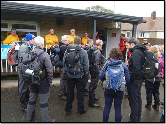
There’s a sharp contrast between the garb of these walkers and that of the runners I’ve set off with the past couple of years.
0901start10902start2

About 50 short course walkers set off, after being warned about a landslide on the track to Erringden Grange that had officially 'blocked' the route. However, unofficially we were advised to 'use your own judgement’.

Three different routes were taken down the first hill, with me being the only walker to follow the route across a couple of fields and down the road taken by last year's runners.

We all converged to head up a very steep and slithery slope to the first checkpoint. The walkers gradually spread out as we continued to the third checkpoint at Ryburn Reservoir, which was disgorging a fair amount of water.

0903byRyburnRes

A team of four, plus a lone walker, forged ahead, with about seven of us strolling along a little more slowly ahead of the rest of the field.

0904ascent

It was a lovely morning, cool enough to walk quickly without overheating, and lacking last year’s bitter northerly breeze. I occasionally pulled out the camera, the next three pictures being taken from the same place on Rishworth Moor, between Ryburn and Green Withens Reservoirs.

0905BlackwoodEdge10906BlackwoodEdge20907BlackwoodEdge3

Runners started to pass us after about 15km/ two and a half hours. Lots came past between the Green Withens and White House checkpoints. I was expecting to see Ken but there was, worryingly, no sign of him.

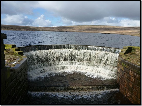
There were several points where my route - basically the one I took last year, downloaded to my phone - was clearly not the quickest or shortest way. It was the scenic route, and given recent rain, a rather wet one under foot. I paused to admire the outflow from Green Withens Reservoir after a rather boggy section.
0908Withens

At this point I was with Lee (last year’s fastest walker), and Tim. They are pictured at the head of this posting heading along the track to the south of Green Withens. They are strong walkers, Lee and Tim, with whom I am pictured below shortly after the Green Withens Reservoir checkpoint. Thanks go to a pro photographer for providing the picture via Tim, and also for taking care of my empty banana.

0910LeeTim

Lee and Tim took the faster road route to the Windy Hill checkpoint – beside the mast in the picture below.

0911bridge1

Meanwhile, I stayed with a couple of others to cross the M62 footbridge via a deep bog and a steep climb. On the bridge we met a jovial team of four who remained a few minutes ahead of me throughout the event, eventually gaining the team award for the second year running. Just one person finished ahead of them.

0912team1

From Windy Hill the route heads north along the Pennine Way for about 10km. A slabbed path leads first to the gnarly summit of Blackstone Edge. As last year, there were good views from here.

0913blackstoneedge1

Looking ahead, I was catching up with Lee as we negotiated the bouldery path interspersed with bogs.

0914Blackstoneedge2

Lee was finding it hard going at this point, although he took a tussocky direct route to the White House checkpoint. Slower than my curvier route along good paths, and I didn’t see him again until the end of the walk. He had gone over and damaged an ankle, which later swelled up annoyingly for him. Ahead of us, the team of four was just in sight, with a lone walker just visible beyond them.

At  the White House checkpoint the long route leaves the short route for an extra eleven miles or so (depending upon the route chosen between the checkpoints). This didn’t confuse the Polka Dot team, who breezed through the checkpoint and off down the road towards Littleborough.

0916whitehouse2

After a few minutes break and a couple of welcome tuna sandwiches I set off up to Blackstone Edge Reservoir in the company of a couple of walking runners. “Which way?” they asked. “The short route goes up to the reservoir then left along the Pennine Way” I offered. And off they went. After a while I met them coming the other way. “We forgot” they said, “we are supposed to be doing the long route!”

Tim and Barry (the latter had been walking at just about my pace but had taken some quicker routes than me) were about 300 metres ahead of me as I strode along the Pennine Way past Blackstone Edge Reservoir, Head Drain, Light Hazzles Reservoir and Warland Reservoir (pictured below).

0917WarlandRes

Whilst the others, who I seemed to be catching very slowly, headed right along the Pennine Way beside Warland Drain, I took the route that I’d fumbled with last year, heading north across Langfield Common to reach the next checkpoint at Lumbutts Church. Plenty of food and drink there to keep me occupied for a while. Just as I set off from the checkpoint, Barry and Tim turned up. Both made a very quick pause and were now just behind me. Tim caught up and we chatted for a while until he fell back a bit whilst I continued with a runner – until the chap ran off into the distance…

It was easy going to the next checkpoint at Erringden Grange, from where I took a convoluted, boggy and intricately steep at times, if basically direct, route to Nab End, where I met a fast runner who reckoned he was in third position on the long route. He was the only participant I saw between Erringden and the end of the walk at Sowerby Cricket Club, where I was greeted by these three stalwarts of the local scouts’ fundraising team.

0918control

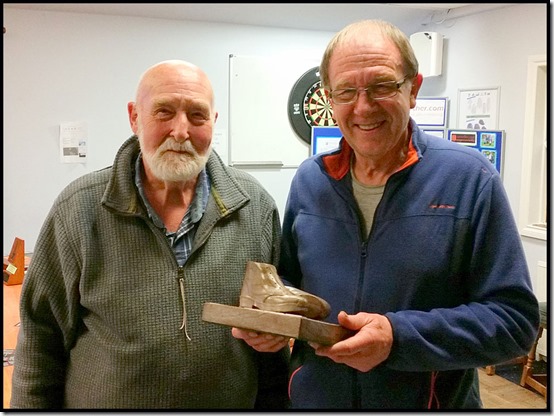
Barry soon wandered over to say hello. He had taken a quicker route, mainly by minor roads, from Erringden to Nab End and finished four minutes ahead of me. Not a surprise, as my pace had dropped from 10 minute kilometres to 15 minute kilometres for a while as I had yomped over the steep, rough ground towards Nab End. He had thereby managed to retain the trophy awarded to the fastest walker over 50 years old. He won it last year as well. I pointed out my name on it next to dates of 1999, 2002 and 2009. Barry, who is older than me, did well, especially with his route planning, though I’m quite happy with my arguably more scenic version with less road walking. Here he is, on the right in the picture, showing well earned delight in taking possession of The Heggars Trophy for another year.
0919barry

I’d finished in a very satisfactory 7 hours, so I now had to wait for Ken to finish running the long route. He had started an hour after me but I reckoned I shouldn’t have too long to wait as despite having to cover an extra eleven miles, he was running.

Or was he?

I chatted to Barry and various others for a while, then when they left I became ensconced with Tim and Lee, and the third of their trio, Howard, who had finished at a slightly more sedate pace and looked fresher than anyone. Luckily, they were enjoying a couple of long beers and before I knew it both the Grand National and 6.30 pm had come and gone and it was several hours since the Polka Dot team had collected their award for being the fastest running team of four on the long route.

0920teamwinners

I’d finished at 3 o’clock. Where was Ken?

Eventually a call came in – “Timed out at Erringden Grange, back soon” was the message. Just as well, I thought, as he would be finishing close to 9pm in the dark if he continued. So the broom wagon brought him in around 7pm and we got away by soon after 7.30. Tim, Lee and Howard got a taxi home at the same time, so that timing was fine, though next year I may choose to walk the long route in order to reduce the waiting time at the end!

Here’s the route I took – about 42 km with 1300 metres of ascent, taking exactly 7 hours.

0999route

(Click for a larger image)

Ken’s route was somewhat longer, especially as it appears he may have wandered off course from time to time! Erringden Grange, where he was timed out, is the checkpoint marked at the very top of the map.

The results aren’t up yet, but at some point they should be available from the drop down menu here.

Previous blog reports on this walk:
2015
2014
2012
2011
2009

All in all a very enjoyable day, both on the walk and afterwards in the club house.

Friday, 8 April 2016

Friday 8 April 2016 – A Mainly Urban Bike Ride

0801warmuseum

In order to attend last night’s gathering of ex UMIST friends, Ken had arrived a day early for the Calderdale Hike. We wanted to get out, but not too energetically, so a local bike ride seemed appropriate.

In Dave’s case it wasn’t very local, as he drove down from Tarleton to join us. Paul was at a loose end and a ten minute bike ride away.

So the four of us enjoyed coffee and cake before setting off down the canal towpath to Sale. Nobody was enticed by my promise of fresh fish from Fleetwood at Daryll’s emporium just round the corner (sorry Daz) but Paul entertained us by allowing his tyre to explode. A new inner tube was inserted, but it protruded through a hole in the tyre.

We were in no hurry, so returned to Timperley, where I knew there was a spare tyre lurking in Ken’s bedroom. It had been there for years. Now it’s on Paul’s bike.

We set off again, passing through Sale and Stretford and turning right at Water’s Meet to head past Old Trafford football stadium. Leaving the canal at Throstle Nest Bridge, we turned sharp left and headed along the banks of the Manchester Ship Canal, past the ugly tower of the War Museum, to cross the canal by the BBC’s buildings at Salford Quays.

The rest of the team posed on the bridge (top photo), then Ken dashed down to the Blue Peter sign with a request that he be pictured there. Request granted.

0802bluepeter

Cycleways and a short road section took us through Eccles to the swing bridge at Barton, from where we returned beside the Bridgewater Canal to Stretford. Here, the Trans Pennine Trail (TPT) passes under the canal. It was blocked by work on the path, but after a bit of faffing we found a way around the obstacle.

Mud was encountered from now on. Quite a lot of it. After crossing the Mersey we found that the path had been diverted around Banky Meadow – a longer but more scenic route than the old one. It was now well past 1 pm and we were all hungry. Paul’s tyre incident was blamed. So we pottered on along the TPT to join the track of the now defunct Altrincham to Lymm (and beyond) railway line, which thankfully was drier than the muddy paths around Carrington Moss.

Paul redeemed himself by leading us down School Lane to Dunham Town and the delights of the Lavender Barn Tea Room. Two huge pots of tea and some nice sandwiches, not to mention the Victoria sponge and other cakes, went down a treat.

0803lavender

Then we pootled off down the muddy canal towpath. Just a short muddy stretch as we picked up the newly  relaid section before passing the Bay Malton and heading back to base.

I reckon it was a leisurely 46 km, with not a lot of ascent despite Anquet (my mapping software) guessing at over 300 metres. If you click on the image you’ll see the route better.

0899route

An excellent and very sociable little outing. Thanks for your company folks.

Cleaning the bikes took some time…

Graffiti from the Southern Half (17)

graffiti28b

It has been a dull week in Timperley. We’ve woken to wet surfaces and rain every morning until today.

I should perhaps have taken some photos last night when 17 ex UMIST folk congregated for a meal at the Midland Hotel in Marple Bridge, but I was too busy chatting. Most of us were fairly local but we rarely meet up these days. Ken had travelled from Ottawa and Gary had just landed from Hawaii, having spent most of this year in New Zealand.

I mentioned both Pat’s books and my books to a few people. It’s strange (to me) that people seem quite happy to spend £5 on a cheesecake that will last them 5 minutes, but not on a book that would provide several hours of enjoyment.

Enjoy the graffiti.

graffiti28

Wednesday, 6 April 2016

Monday, 4 April 2016

Saturday 2 April 2016 – A Day at Home

0205PaulL

Well, a day at home on a Saturday always involves a visit to a parkrun, usually – as today – at Wythenshawe.

Paul was today’s run director, leaving Andy (below) to enjoy a fast jog despite a delicate calf muscle.

0202Andy

Nobody seemed particularly bothered by the light rain, though Andy W, below on the left, looks as if he would have benefited from having my heated gloves.

0203AndyPaul

There were only 160 runners today, fewer than usual because of the rain, and the fact that many regulars would be taking part in the Wilmslow Half Marathon the following day. So they took a day off.

0204wetstart

The results are here.

The hall had a little more scaffolding, but no workers today.

0201Wythenshawe1

After getting home we were soon visited by Bill, on a tour of the UK from his Aberdeen base. Here’s the picture taken for his ‘Road Tour’ album as he disappeared back to a caravan site in Knutsford. It was good to see you, Bill.

0206garden

Friday 1 April 2016 – A Stroll Around Alderley Edge

0102view1

For the first of a short series of morning walks, Paul and Andrew turned up to join me at the Wizard car park on a dull, cool, dry day.

Our route was vaguely familiar, resembling some of those taken on previous visits, though there are many options hereabouts. We set off on a newly constructed National Trust path to the north, passing the viewpoint shown above and soon reaching another viewpoint at a barren area where the old mine entrance is fenced off.

0101AEpath

On a good day there are wide ranging views over Cheshire and towards Manchester. There’s an Armada Beacon near here, built on top of a Bronze Age ‘bowl barrow’ or burial mound.

During the time of the Spanish Armada and undoubtedly hundreds of years before this time, the Edge had very few trees and was predominantly heathland, making it a perfect vantage point.

It is said that in 1588 it took 12 hours for the news that the Spanish Armada had been sighted to travel from the south coast of England all the way to York.

0103view2

The area is riddled with mines and quarries. On our way down to Findlow Farm we passed a long abandoned quarry, the path drawing us around its eastern edge rather than my planned route around the other side. One of a number of ‘meanders’ away from today’s planned route.

0106quarry

The path to Whitehall Brook was a trifle muddy, but feet remained dry today despite the use of trail shoes.

0107mud

Beyond the posh exterior of Faulkner’s (not a) Farm, we reached Mottram Bridge and the Bollin Valley Way (BVW). The last couple of times I was here, the path was blocked by a landslip, but now a diversionary path has been built, so next time I’ll try the BVW route towards Prestbury. You can just see the new path in the distance to the right of the river.

0109bollin

Soon afterwards, at Top o’ th’ Hill, some red ‘Pedestrians’ signs directed us into a building site to a dead end by a fence where our 1:25,000 map showed a public footpath. After a debate with the site manager we concluded that the footpath must have been officially diverted to make room for the privacy of one Tom O’Connor, of O’Connor Utilities Ltd, in what in a couple of years time will be his fancy new mansion, no doubt mimicking the ‘footprint’ of the old farm and its outbuildings. We appear to have arrived from a direction where the signage and explanation for the closed path were inadequate.

0110connor1

After eventually finding our way around the obstruction, we continued to a quiet spot for tea and cake, before re-joining the BVW at a footbridge over the river, immediately leaving that route to cross a golf course on a path leading to Woodside Farm, also a construction site, but unlike the O’Connor construction, this farm was being renovated rather than being replaced.

A ‘path’ leading south was full of horses that had churned it into a deep quagmire, so nobody objected when I decided to introduce an extra ‘meander’ that took us down the driveway to the farm, past vibrant daffodils in Smithy Lane.

0116daffs

Beyond the Bull’s Head, a pleasant path took us past Brook House Farm and Hunter’s Pool, to re-join our planned route along the North Cheshire Way, which we followed up Daniel Hill (pictured below) and past Edge House Farm (another construction site) to the Edge and the Wizard Car Park.

0120wood

The Wizard tea shop was closed for renovation (if the National Trust can find a local builder who isn’t ripping down a farmhouse to supplant it with a mansion), so we headed into Alderley Edge for coffees, with bagels and cream cheese at a circular cafĂ© that apparently used to be part of a motor dealership near the station. It was surprisingly good.

Here’s our route – about 14 km with 200 metres ascent, taking 3.5 hours. Click on the image to get a larger one.

0199route

Thanks to Paul and Andrew for their company today on this pleasant stroll.

Other Alderley Edge walks are recorded here.

The three other morning walks currently planned are detailed below. All are welcome.

Thursday 28 April
Morning Walk 2 - Lindow Moss (Wilmslow) and Styal Woods - 8.5 miles (13.5 km) from the Lindow Moss car park next to the Boddington Arms - SJ 832 814, starting at 10.00 am.

Friday 6 May
Morning Walk 3 - Danebridge (for Hanging Stone and Lud's Church) - 6.5 miles (11 km) from the bridge down the road from the Ship Inn - SJ 964 652, starting at 10.00 am.

Wednesday 1 June
Morning Walk 4 - 7.5 miles (12 km) from the car park at Trentabank (beyond the Leathers Smithy in Langley) - SJ 961 711, starting at 10.00 am.