Sue and Martin in Mallorca 2019

Sue and Martin in Mallorca 2019
On the Archduke's Path in Mallorca

Thursday, 8 September 2011

Wednesday 7 September 2011 - Sokulupinar (2000 metres) to Dipsiz Lake (2950 metres) and back

Approx 22km, 1000m ascent, 8.5 hours including stops.

Last night's late sun was countered by this morning's late sun. It didn't hit the camp site until after we had set off at 8.40am up the track past the cave.

Breakfast included 'borek' a calzone with cheese enclosed in the toasted dough. All of Adam's making and delicious. We have a good cook.

After an hour we reached the end of the jeep track by a spring and a flock of sheep guarded by dogs. A large flock of snow finches flitted from place to place in the neighbourhood. A nearby wheatear pecked away unconcernedly, scorning the antics of the finches.

From there, a good mountain path past St John's Wort and other Alpine flowers, many with fleshy leaves to retain moisture in the dry conditions, led all the way up to our destination - a high lake, seriously depleted at this time of year through evaporation, surrounded by a mountain cirque.

It took 4.5 hours to get there. We were down to 16 today as Dave had been ordered to rest and Carey had been encouraged to spend a day with Ramazan, our Jeep driver. This would enable him to enjoy an exploration of the nearby village and gain a better insight into the local culture.

The sun beat down from a dark blue sky all day. Sunglasses were worn. Lunch was taken beside the lake.

On the descent we were invited into a shepherd family's tent, where a twelve year old boy, Mohammed, laid out a selection of his mum's knitted socks and gloves, etc. There was much interest and after a little bargaining the Welsh Witches splashed out 50 New Turkish Lire on some snazzy footwear for their coven. The tent was fairly spacious, with a small kitchen area and a blue tarpaulin over a roof constructed of wooden slats and used as a sort of cupboard. A felt overcoat was produced and Mohammed delighted his audience by demonstrating its use as a sleeping bag. Like any respectable household, this one required guests to remove their shoes before entering.

On leaving the tent, some of us moved quickly down the valley on skittery scree, past a veritable garden of Autumn Crocuses. It wasn't as steep as the stuff that had yesterday claimed at least seven fallers and ripped Tessa's shorts.

Three tents were pitched near the next spring at 2500 metres, beyond which a steep gully led towards the peaks that the tents' owners were scaling. They were not walkers.

We waited here, and lower down above the Jeep track and sheep pasture, just in case Turan wanted us to pass the sheep as one group, to minimise dog risk. He did want that, and he single-handedly saved us from being ravaged by four 4-legged enforcers, using a mixture of Turkish swear words and two walking poles.

Soon we encountered our Jeep, with Ramazan and Carey, who grinned and hijacked Joanne and Tessa for an early shower. Most of the rest of us carried on down past spent spurge and asphodel for tea and Turkish Delight that took the entire cap off one of my teeth.

Meanwhile, Sue, Susan and Roy decided to explore the cave near the campsite. It turned out to be an overhang full of sheep droppings.

After another lovely sunset (pictured), we enjoyed more of Adam's cooking before a controversial suggestion from Turan sent most of the group scampering to bed.

Sent using BlackBerry® from Orange

Wednesday, 7 September 2011

Tuesday 6 September 2011 - Sari Memedin Yurdu (1800 metres) to Sokulupinar (2000 metres)

Approx 11km, 700m ascent, 7 hours including stops and searches.

Another 'blue sky' day. After paying off our assistant cook and assembling for the now routine 9 o'clock start, we strolled up the Emli Valley, welcoming the shade from the cedar trees with their light coloured pointy-up cones. It was a hot day.

The switchback path, if you can call a single five kilometre zigzag that, took us along a sandy path, past thistles and spurges, gently up to about the same height as yesterday - 2500 metres. On the way, Tessa lost the mouthpiece of her platypus (piped drinking system), and a search party set off back to comb the area in which it had been spotted. This took some time. The seven strong vanguard led by Turan hadn't noticed the incident, which was hidden from their view. So it was a relieved Turan, who had returned down the trail to investigate, when I explained the problem (I'd gone on to meet him). The rest of the vanguard, sadly, didn't buy my 'We saw a Mountain Lion' story!

Before this incident, on the turn of the switchback, a needle of rock came into view. "I want to climb that" announced Sue. "You can't" asserted Turan. So she made do with the above photo.

After passing a large German group heading in the opposite direction, the only people we have encountered on the trail, we continued along a high path to a succulent spring. Time for lunch, with a welcoming cool breeze.

Dave 'my knee's gone pop' wasn't with us today - he took the easy route in the jeep, so it was just seventeen who continued along a lovely contouring path via a distinctive rocky tor, followed by some entertainingly skittery scree, to our destination - a host of two tone green tents in an even greener field that is subject to constant irrigation by way of a sprinkler.

En route we saw a Kestrel hover and dive, passed some 'French tents', my nose had a bleed, and Turan became the proud owner of a secondhand high heeled shoe.

The campsite is in a splendid position with a fine mountain backdrop as well as views across a deep valley towards the continuing chain of mountains to the west.

After our 4pm arrival, and 30 minutes of tea and biscuits and Turkish Delight, most of us set about washing off the dust and grime of the day. Some used the campsite showers, as usual - unheated; Sue and I chose the garden sprinkler. Interesting!

Time flew by. A 'marmot' was spotted in camp. It looked more like a ferret to me. Turan explained that in his youth he would catch these poor beasts by pouring water down their burrows and then chasing the soggy animals that emerged, weighed down by their wet fur, to exhaustion. I expect they were then savoured as a breakfast titbit in much the same way as Sue downed her grasshopper delicacy for breakfast along with this morning's boiled egg.

Sunset was magical, with pink light on the mountains above us, and great opportunities to capture silhouettes against the setting sun.

Dinner in the large open tent with its trestle table for 18, was the usual jolly gathering, after which some of us managed to stay up until after 9pm!

Sent using BlackBerry® from Orange

Tuesday, 6 September 2011

The Internet in Turkey

I've been surprised to get a signal in the 'High Taurus', but the internet connection is somewhat 'flaky'.

I'm doing my best, but don't be surprised if I go off air for a while.

The picture is of Sue's breakfast.

Have fun

Martin

Sent using BlackBerry® from Orange

Monday 5 September 2011 - A Mountain Walk from Sari Memedin Yurdu (1800 metres)

Approx 6km, 700m ascent, 6.5 hours including stops.

Another 9am start for this circular stroll into the mountains shown in yesterday's photo, from our 'pre-set' camp site at 1800 metres in the Emli Valley.

Overnight, wolves were howling and Daves were snoring.

During breakfast the sun hit the camp and normal clothing (t-shirts) was resumed.

So we enjoyed a sunny 700 metre ascent to our lunch stop, and an equally sunny descent back to camp to complete the short circuit.

Today's picture of Carey illustrates the magnificent scenery hereabouts, but fails to capture the image of a Golden Eagle soaring over the mountain tops.

That was first thing, as we left 'Fly Camp' as it is rightly known, in Mediterranean weather. The stony path soon became strewn with Autumn Crocuses, and Turan spotted ibex in the distance. They are not as tame here as in the Maritime Alps as they are hunted, but we saw more females with their young as we approached our lunch spot at the day's high point around 2500 metres.

A Red-fronted Serine drank from the spring at this point, which like a number of locations hereabouts used to be the summer home of up to ten local families - tending their sheep high in the mountains to avoid the summer heat in their villages.

Martins, Flycatchers, Pinks, Spurges and much more by way of flora and fauna entertained us on the way down. During this time, Carey suffered a gear failure - one of his borrowed but brand new Pacerpoles lost its tip. Oops! Meanwhile one Dave managed to roll over some rather prickly thistles in his attempt to become a pin cushion. Ouch! The other Dave suddenly ground to a halt - "My knee's gone 'pop'" he exclaimed. Oh dear! His dodgy digit was dutifully bandaged and Lil nursed him down to safety.

By 3.30 we were back at camp, supping tea and debating how best to 'shower'. Most people seemed to choose the 'bucket and hose' system.

By and by, dinner was served. "Enjoy your grasshopper soup" announced Adam with a wry smile. (Actually, not knowing Turkish, I have no idea what he said!)

A few beers later, Uno, a card game - an adult version of 'snap' - was attempted, using the South Wales school of Double Dutch rules. Amongst the eleven who played, friends were won and lost...

Sent using BlackBerry® from Orange

Monday, 5 September 2011

Sunday 4 September 2011 - Marti Mahallesi to Sari Memedin Yurdu (1800 metres)

Approx 10km, 300m ascent, 5 hours including stops.

After a warm night at 1600 metres I woke to a 6am call to prayers. Some had been woken to an earlier call at 5.30! A lie in and gear sort until breakfast at 8 was in order. This is a holiday. A leisurely trip. No 'Alpine' starts are planned.

Breakfast of water melon, cheese salad, bread and the usual accompaniments, and sausage omelette (did I tell you the area is famous for its sausages), was washed down with copious tea and coffee by the assembled group, now fully recovered from its jet lag, early start, and misplaced baggage/passport/hotel.

Here's the cast:
Martin and Sue - the Timperley Travellers
Susan and Roy, fellow TGO Challengers, seeking refuge from Hurricane Irene's devastation in their home town of Glastonbury, Connecticut
Dave and Elizabeth (Lil) from Hexham
Dave and Joanna from Harlow
Jane 'Egg' seeking refuge from the rigours of a yacht on the Bosphorus, and an audience for her tales of 'storm and tempest on the TGO Challenge 2011'
Alan, erstwhile TGO Challenger and landlord of the Greyhound in Burston (Staffordshire)
Tessa from Bowdon, who works in Leeds but lives very close to us
Anne from Newcastle, a University worker
Breda, Karen and Ann, seeking refuge from the autumnal ambience of South Wales
Carey, assistant editor of TGO Magazine, our junior member, a member of the Paparazzi - seeking a cover shot for the magazine
Turan - our local leader on this KE Adventure Travel trip
Elif, Turan's assistant, a budding rock climber
Adam, our cook - by far the most important member of our team
Various other 'assistants' and their own assistants...

We left in the bus at around 9 o' clock and after 5-10 minutes were dropped off at the start of a walk that took us across dusty scrubland with prickly plants under a hot sun.

There was no path, but the going was easy. By and by we paused for elevenses in the shade of a large rock. Beyond here, Sue found a friend - a giant grasshopper that over the next 500 metres wandered nonchalantly all the way down from her hat to regain terra firma.

Whilst late in the season, there are still a fair number of plants in flower including Carline like thistles and a variety of mullein.

We continued over desert like scrub with fine mountain views. The scenery hereabouts is very 'Dolomitic', with steep rock faces towering above us. A rough descent into a deep gorge - Kazkali Bogazi - delivered us to a lunch spot near a bolted rock climb. "I've been up there" commented Elif, Turan's demure assistant, who was clearly contracted to act as 'sweeper' for our group. A small group of climbers studiously ignored our noisy group.

Moving off again, our 18 strong band took another good hour to reach our campsite by around 2.15.

Time for tea and biscuits.

It's a lovely spot. A formal campsite with facilities and several 'camping fields'. We have the best of these (pictured), with a huge mountain backdrop. There's a large open tent to the right of the photo in which our meals are served.

A relaxing afternoon and evening were enjoyed by all, featuring a lengthy meal and culminating in Turan's exposition of 'the sky at night'.

Mark and Alan - thanks for your respective comments. I have Will's book 'In View of Monte Viso', Mark - an Alpine classic.

Ken - only three of us went down to that crumbling brickwork - even Reg declined to do that! It's a shame, but there really does seem to be no current use for the fine viaduct.

Sent using BlackBerry® from Orange

Sunday, 4 September 2011

Saturday 3 September 2011 - Demirka

Here we are at a camping place in the village of Demirka. (Photo taken 'tomorrow morning'.)

The journey from Reading, where Ian kindly put us up last night before dashing off to Leysin himself, started with a 3.30am taxi ride and ended after a two and a half hour bus ride from Kayseri, via another bus ride and two Turkish Airlines flights - Heathrow to Kayseri via Istanbul.

It was quite a smooth journey for most of us, but Carey had a bit of an epic yesterday in Istanbul - due to 'disappearing' luggage, passport and hotel...

All is now well though, and all 16 of us plus guides and cook are happily installed in a flotilla of tents, and have enjoyed an excellent dinner.

We flew over arid looking terrain, to Kayseri, which is famous for sofas, sunflower, sausages and potatoes. It's a thriving metropolis whose inhabitants live mainly in ugly blocks of flats.

Beyond there, the bus ride took us past fields of golden stubble, potatoes and sweetcorn, in an area that looks much more fertile from the ground than from above.

We rose from about 1100 metres to this plateau at 1600 metres, and finished about 4km from the home of Touran, KE Adventure Travel's local guide - our 'leader' for the next ten days.

Whilst settling into the tents, we enjoyed watching the late sunlight on the mountains to our east. They tower over 2000 metres above us. From here they look like barren Alpine peaks, a bit like certain of the Dolomites. We'll get a closer look tomorrow, when I'll also find time to say a few more words about the cast of sixteen who are embarking on this TGO Magazine '2011 Readers Trek'.

Sent using BlackBerry® from Orange

Thursday, 1 September 2011

Wednesday 31 August 2011 – The Red Rock Express

Plaque at the site of Red Rock Station
A cast of 20 arrived at the Bay Horse in Adlington, for this mixture of a Railway Ramble and a historic trip around Adlington and Standish, courtesy of East Lancashire LDWA ‘Plodders’, led by Reg.

I was late, so missed Reg’s 15 minute introduction to this fine little ramble.  To say the route was convoluted is something of an understatement – I’ve done my best to plot it on the map shown at the foot of this posting, but Reg had devised a plan that was calculated to confuse even the locals.

We set off at 10.40am and headed directly to the Leeds & Liverpool Canal, joining it by the A5106/A6 junction.

The pleasant towpath soon passed a small marina.

The Leeds & Liverpool Canal

We marched on as I listened to Anne’s ‘Tales from the Recipe Page’.  Eventually White Bear Marina, in Adlington, was reached.

White Bear Marina, Adlington

The Marina Café is staffed by Down Syndrome sufferers who provide a most efficient, friendly and welcoming service.  (You should pop round here from time to time, Robert and Lyn – you live just around the corner.)

On this last day of August, whilst overcast, the day was plenty warm enough to stay outside.

The Marina Cafe, Adlington

Suitably gorged with coffee and cake, we went back over the canal to rejoin the towpath and annoy lots of fishermen engaged in a competition.  Near the café are the remains of the original steps down to the old platform of White Bear Station, which was closed to passengers in 1960.  The stone building was part of the station; factory on the right of the picture encroaches on the course of the old railway line.  There’s more here.

The Site of White Bear Station

We soon left the fishermen to catch their tiddlers and headed under the canal, beside the River Douglas, to join the course of a dismantled railway.  It led down to Red Rock Station, built in 1869 – see the plaque at the head of this posting.  The station has now been incorporated into an impressive private house.

Red Rock Station, now a private house

Here’s what it used to look like – this photo may have been taken from almost the exact same spot, albeit nearly 60 years ago. (I’ve borrowed the picture from here.)

The railway at Red Rock, 1952

Just beyond the station, Reg had organised a butty fest – huge platters of butties provided by the Bay Horse and transported to a small car park on Red Rock Lane by one of his neighbours.  A splendid little break.

A short way down the lane, we turned left along Chorley Road and past some contrasting gardens…

A garden on Chorley Road Another garden on Chorley Road

Now Reg’s imaginative route led us around the back of some houses beside a plethora (yes, a plethora) of dismantled railways, eventually leading to a huge, crumbling viaduct.

The crumbling arch of a massive viaduct

The complex pattern of lines and link lines and goods lines to mines and quarries has now been largely dismantled and whilst some of the tracks can be walked, there are few through routes and lots of dead ends due to dismantled bridges and the crumbling viaduct.

A crossover of LMS railways

Returning to Chorley Road, we followed, almost via the site of Boars Head Station, the course of an old branch line, which took us under the current main line between Warrington and Preston.  The old line joined the line that is still open at Standish Station, access to which was through the wall shown below that has been bricked up, with the main line now passing over the green bridge.

The bricked up entrance to Standish Station

Reg’s route turned left after going under the bridge, and headed pleasantly beside crops until the next lane was reached.  We were surprised that the crops hadn’t been harvested.  They looked ‘tired’.

Unharvested field between the LMS Railway and White Bridge Brook

Perhaps the farm machinery wasn’t up to it.

Tractor

The 20 walkers were by now a bit tired.  They had completed the 10 miles stipulated by Reg in his advertising literature, and had reached his predicted finishing time of 3.30pm.  But there were still nearly three miles to go!

The blame was placed fairly and squarely on the antics of one of the younger members, R Norman (56), who is really not old enough to be eligible as a ‘Plodder’.  He had persistently sped on ahead of the group, leading various members astray down false trails eschewed by Reg, whilst muttering “I know this area like the back of my hand”.

At one point I think I saw this vagabond disappearing into the public bar of the White Crow.

I checked out R Norman’s hand.  It was very swollen today!

The site of Ellerbeck Colliery was passed as we returned towards Adlington. The colliery closed in 1965 after nearly 90 years of use, and today there are just a few signs of its existence amongst the renovated and extended buildings on the old site.

Ellerbeck - site of old mine workings

Back across the canal, there were sighs of dismay as a duo of Johns looked up at the final hill.  They plodded on up the hill together with other stragglers, with Reg bringing up the rear after his final lecture.

Straggling up the final hill

The beer in the Bay Horse was very refreshing.

The Bay Horse, Adlington

Here’s the approximate route – about 21km, with 250 metres ascent, taking about 5.5 hours including an hour of breaks.

The approximate route - 21km, 250 metres ascent, 5.5 hours

There will be an LDWA report on this walk, maybe here. (It looks as if some of the photo uploading to this page has gone berserk, perhaps it’ll be calmed down soon…)

That’s all for now, and maybe for a while, as tomorrow Sue and I embark on a trip that may see us ‘out of range’ for over a week.

The next ‘Plodders’ walk is just 8 miles, leaving on ‘Part 4’ of the Salford Trail, from Irlam Station, at 11.00am on Tuesday 20 September.  There’s also a ‘Topwalks’ walk featuring the Monsal Trail, starting from Taddington at 10.00am on Sunday 18 September.  All are welcome, more details here.

August Bank Holiday Weekend

Andrea and Thomas's plate of sushi

Bank Holiday weekends:  we usually are either abroad or we stay at home and avoid the crowds.  This weekend, at home preparing for the next trip, we enjoyed a few rather enjoyable interludes, and we did avoid the crowds.

Friday night saw our house minders, Andrea and Thomas, here for a meal.  They even brought the starter, pictured above, with them.  It was delicious, and we suspect it took them longer to prepare the sushi than it took us to cook the rest of the meal.

Thank you, A + T.

A sushi starter

Saturday brought a visit from Kate and Jake, now 18 weeks old.  Holiday weekends draw lots of railway enthusiasts to the track around Walton Park, which is a short stroll up the canal from home. 

I suspect young Jake will enjoy a few visits to this spot in days to come.

Walton Park's miniature railway

The gardens at Walton Park are in good form, there’s plenty of space for games, and there are some new climbing frames for young and older children.  A fine amenity.

Walton Park, Sale

Kate and Jake (18 weeks)

Saturday afternoon saw me heading off to Monsal Head, where Terry had arranged a ‘meet’ for bloggers and others, also attended by some outdoors suppliers such as RAB and Terra Nova, and by Gareth from Webtogs, who supply several of us with outdoor gear for testing and review.

After a beer with Mick and Gayle (they needed one after discovering Monk’s Dale earlier in the afternoon), we joined a throng at the nearby campsite.  It drizzled.  Mick was testing a rather gaudy yellow ‘weather resistant top’.

Bloggers and others at Monsal Head

Gareth demonstrated several ‘Nemo’ tents from Webtogs’ lightweight tent range.  This one weighs under two kilos and has inflatable poles.

Interesting!

Gareth blows up a tent!

Mick and Gayle tried out the 1.4kg Nemo Obi 2P tent and thought it may be a little tight for them.  These are interesting tents from the USA.  I’m curious to find out what the professional reviewers think of them, and I’m looking forward to borrowing the Obi 1P Elite from Webtogs to test and review, hopefully in the Autumn.

Mick and Gayle test a tent (and a windshirt)

Mick continued to test the top to which he has become seriously attached.  Gareth wondered whether it doubled as pyjamas…

Meanwhile, a rainbow appeared through the drizzle.

Rainbow at Monsal Head

The viaduct at Monsal Head has appeared before on these pages.  It was a rather dull sunset on this occasion, principally because the sun had gone down before Jamie and I reached the viewpoint.

Monsal Viaduct at dusk

It was good to meet Jamie, another blogger, for a little longer than our previous encounter in Sainsbury’s, and to discover that I know several of his work colleagues.

It was also good to meet fellow Webtogs tester James and his dog Reuben, and various others who were enjoying the meet.

Sunday afternoon saw Sue and me back in the company of A + T, this time at Altrincham Beer Festival.

Boozers at Altrincham Beer Festival

There was a fine array of beers, and some Spanish and Indian food.

A young train driver entertained us with some ‘tales from the driving seat’.  He was (refreshingly) breathtakingly enthusiastic about his job.

A good choice of beers

“Do you want my old bike” texted Dave on Sunday afternoon.  He’s gone through a rough time recently with his elderly dad, and deserves a treat – in Dave’s case, a new bike.  So Dave’s five year old Specialized Stumpjumper FSR Comp was up for grabs.

I’ve been pondering about getting a new bike for a while, and only the enthusiasm at my local bike shop for my old steel bike stopped me from getting a new one late last year.

I couldn’t resist the temptation, so Monday morning saw me meeting Dave and exchanging a piece of paper for ‘Stumpy’, my new full suspension bike.  I’ll be keeping the old Shogun Trailbreaker for the flatter local rides, but Stumpy, with its full suspension, should be great for the ‘rougher’ stuff.

Martin's bikes

I’ll be getting a few extra bits, like mudguards, so the appearance may change a bit, but I’m looking forward to using this new ‘steed’.

All in all, a very pleasant Bank Holiday.

Wednesday, 31 August 2011

Thursday 25 August 2011 – Bury to Ramsbottom, an evening stroll

Peel Monument after sunset

It’s nearly an hour’s journey on the tram from Timperley to Bury, but Sue and I made it easily in time for the 7.30pm start. 

The interchange was deserted; not a walking boot to be seen; we were destined to be on our own tonight, as our South Manchester companions seem reluctant to come north, and Alan has shingles.

The centre of Bury was laden with flowers.
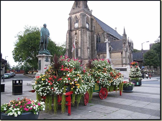
Bury centre

Even the pubs had the appearance of a floral tribute to Bury’s most famous statesman, Sir Robert Peel (1788 - 1850).

Bury hostelries

To follow our route, go past the bus stands and up the street past some statues to the church and the statue of Peel, where a left turn signed to the East Lancashire Railway takes you past the terminus of that railway.

Turn right down Castlecroft Way, and under the by-pass, before turning left down Dunster Road and right before a factory, down Harvard Road.  Behind the factory a thin path leads to the banks of the River Irwell, and a peaceful haven within a few minutes of the centre of the town.

The pleasant stretch of riverside leads past waterfalls to a weir and a footbridge that you use to cross the river.

The open country that you seem to have found, is in fact just a thin strip of farmland with views north to the wind farm on Harden Moor.

A view north, from the Irwell Valley

The junction with Woodhill Road is soon reached. A right turn down a quiet road leads past suburban housing.  Minor roads lead to new housing estates, whilst older properties like the one below line the ‘main’ road.

A typical stone house at Woodhill House plaque


What’s this all about, then?


The road ends at the entrance to Burrs Country Park.  The industrial hamlet of Burrs stems from the late 1700s and the construction of a water powered cotton spinning mill (see below).  The mill closed in 1933, but the Park has recently been developed as an industrial heritage centre.

Here’s a picture from within the park – in the late light it may look boring, but it’s actually full of interest.

In Burrs Country Park

The picture was taken from the mill floor.  There has been a mill here since Arkwright built a small water powered mill in 1790.  Originally a cotton mill, it was later used for glue and paper, and became a five storey monster.  Immediately beyond the Himalayan Balsam is the wheel pit, which dates from about 1850 and housed one of the biggest water wheels in the north west. 

The rectangular brickwork beyond the railings is the engine bed; it contained a steam powered beam engine that delivered 100 horse power.  A combination of the water wheel and the steam engine was used to power the mill machinery, the steam engine being used when there was insufficient water to power the wheel.

In the background is the brickwork over which the Bury to Rawtenstall East Lancs Railway carried passengers from 1846 to 1972.  Freight continued to be hauled on this line until 1980, when it was closed to all rail traffic.  Luckily, an enthusiastic Preservation Society got the line up and running again by 1987, and it continues to thrive in the hands of enthusiastic volunteers.

The remaining chimney dates from around 1850.

Mill chimney at Burrs

The chimney is reached after making your way through the complex of building foundations, forking right to go under the railway via the arches in the picture above, and following the riverside back under the railway, before crossing a footbridge that leads to the Brown Cow Public House, which was built as a farm in 1752, before the Industrial Revolution took hold in Lancashire.

Beyond the chimney and some restored mill buildings, the path heads towards the mill goit, a narrow canal carrying water from the river to the mill wheel.  We enjoyed the last of the sunset alongside the goit on a narrow embankment above the river valley, with a fine view towards the Peel Monument (pictured above), the memorial tower to Sir Robert Peel high above Ramsbottom, planned and erected in 1852 at the same time as Bury was preparing its statue to the then recently deceased statesman.

The path reaches a splendid weir.  It was almost dark by the time we reached this around 8.30, but I managed one last photo before the torch came out.
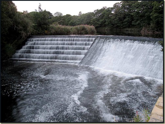
A weir on the River Irwell

I’ve included the rest of the route description below*, for those who may wish to follow in our footsteps – this makes an excellent 2-3 hour stroll.

Sue and I continued without difficulty along the route in increasing gloom and eventual moonless darkness.  Beyond Springfield Farm we paused to admire a flurry of bats flitting around in the woodland – possibly the Common Pipistrelle.

A lovely woodland path leads to Summerseat, and from Brooksbottom a wonderfully preserved cobbled path leads over a railway tunnel and eventually to Nuttall Park, from where Ramsbottom is but a few minutes’ stroll.

‘Ramsbottom’ – why name a town after a male sheep, you may ask?  Why not?   Because it’s named after wild garlic – Ramsons – or so I’m led to believe. ‘The valley of wild garlic.’ 

Anyway Robert Peel senior opened a calico works here in 1783 and this led to the prosperity of the town.  More recently the reopening of the East Lancashire Railway has helped to maintain the town’s good fortune.

It’s easy to find a bus back to Bury (472/473/474), though after finishing the 10km walk at around 9.30pm it did take us an hour and a half to get back to Timperley.

Here’s the route.

Our route - 10 km, 180 metres ascent, around 2 hours

* From the weir, follow the riverside path for about 400 metres, until the path leaves the river, crosses an embankment, and joins a track leading under the railway and past Springfield Farm, with it’s well manicured lawns and entertaining bird displays.

Follow the farm track uphill to about 100 metres beyond the farm, turning left up a path marked as being the route of the Irwell Way.  The narrow path between fences follows field edges and passes a small pond before descending alongside the railway to a stile which leads over the railway line.

Cross the line to a lane, and cross the river via the bridge, at the far side of which turn right through a narrow gap to find a grassy path through beech trees above the river.  Follow the path, keeping right, until it emerges at a road, where you turn right into this lane, which goes under a bridge to reach Summerseat Station.

Immediately past the station take a track on the left that runs parallel with the railway and continue in the same direction past a group of new cottages to rejoin the road at Brooksbottom.

Turn left and go back under the railway, 50 metres after which turn right at East View and head up a slope directly away from the road.  This leads to a fine cobbled track over a railway tunnel.  Continue along this until after passing to the right of a housing estate a t-junction is reached.  Go right, down the hill, along a track that eventually arrives at a footbridge across the river.  Cross the bridge and continue along the track until Nuttall Park is reached on your left.

There are many ways to Ramsbottom from here – most easily, by heading to the car park and following the footpath signs to Ramsbottom via a track that goes under the railway and over the river, then past a TNT lorry depot.

The walk could be extended to both the south and the north, to provide a longer day out.

Enjoy!

[Walk taken from ‘Best Pub Walks in & around Manchester’ – Speakman, Speakman & Coates]

Tuesday, 30 August 2011

Wednesday 24 August 2011 – A Day out at Shugborough

Shugborough - The House

A sunny August day saw Sue, Dot and me visiting the home of Lord Lichfield (1939-2005), Shugborough, near Stafford.  The house, pictured above, dates from about 1693, when William Anson (1656–1720) demolished an old house and created the new mansion.

A visit starts some distance from the mansion, near the estate farm, and walled gardens crammed with produce comprise the first area you pass through.

Shugborough - The Walled Garden

In 1805, Thomas Anson recognised the value of his head gardener, and built him a fine house just inside the walled garden.  Large glass houses extended on either side of the house.

Shugborough - The Gardener's House

Leaving the walled garden, you pass some craft workshops and the farm, with its children’s play area, from where it’s a ten minute walk or a short ride on a shuttle train to the main house. 

The Tower of the Winds is soon passed.  This replica of a classical monument, built around 1765, was once used as a dairy downstairs and a gambling den upstairs.  It was reached by bridges to the porches over a surrounding lake.

Shugborough - Tower of the Winds

Fortunes may have been won and lost in this building.  There is much reference to the paucity of original artifacts in the main house, though some do remain, due to ‘The Great Sale of 1842’, when many of the contents were sold to meet gambling debts.  More on the history of Shugborough can be found here.

However, several fine plasterwork ceilings by Vassalli have survived.  

Shugborough - Plasterwork ceiling by Vassalli

The library is formed from two adjoining rooms, the narrow division between which has been concealed by the clever use of mirrors.

Shugborough - the Library

Very close to the house, the Essex Bridge is a packhorse bridge over the River Trent, one hundred yards downstream of its junction with the River Sow.  It was allegedly built in 1550 by the then Earl of Essex for Queen Elizabeth I so that when she visited the estate she could go hunting in the woodland around the local village. It is now the longest remaining packhorse bridge in England with 14 of its original 40 span arches left.

Shugborough - The Essex Bridge

Beyond the Essex Bridge, a lock on the Trent and Mersey Canal near the village of Great Haywood was the scene of a queue of holiday barges.  The canal dates from 1777.

The Trent and Mersey Canal at Shugborough

The Chinese House was completed in 1747 - originally built on an island, it is now on the 'mainland' following the rerouting of the River Sow in 1795.

Shugborough - The Chinese House

Nearby, the Shepherd's Monument - constructed around 1749, takes its name from the marble relief based on a painting by Nicholas Poussin.  The inscription is rumoured to be connected with the Holy Grail.

Shugborough - The Shepherd's Monument

The Doric Temple was built circa 1760 - it's one of two copies of the Temple of Hephaistos in Athens by James 'Athenian' Stewart and is thought to be one of the first accurate revived Greek Doric Temples in Europe.

Shugborough - The Doric Temple

'The Ruin' dates from around 1749 - it was originally more extensive and included a pigeon house and a classical colonnade which were washed away by floods in the late C18.

Shugborough - The Ruin

Walking by the riverside, you come to a blue bridge which crosses over to an island arboretum much loved by the late Lord Lichfield.

We strolled all the way along the island, back to the red bridge, from where a path leads past the rear of the house.

Shugborough - from the rear of the house

Throughout our visit, we’d seen evidence of a ‘Sculpture Trail’ – they seem to get everywhere these days!

Shugborough - on the Sculpture Trail

Finally, near the red bridge, and passed whilst we were under a rather unphotogenic black cloud, The Cat's Monument, built in around 1749, is situated on the private island created where the Rivers Sow and Trent join.  It is thought to commemorate a cat that travelled around the world with Admiral Anson between 1740 and 1744.  (If you have time to click on that link, it’s quite a story!)

Shugborough - The Cat's Monument 
Whilst I imagine this is more than enough for most readers, there is a slide show with a few more images here.

There are plenty of places to park nearby and combine a country walk through the pleasant woodland of Cannock Chase and/or a bimble along the canal towpath, incorporating a visit to Shugborough, which has an excellent tea shop.