
 Yesterday, after visiting the Nature Reserve in Te Anau, which looks after injured birds, such as the rare Takahe, we drove north in the Silver Bullet (pictured above) to Wanaka, to the aptly named Mountainview Backpackers. At Kingston, at the south end of Lake Wakatipu, we picnicked on the shore, with the whistle and hiss of the Kingston Flyer, a black steam engine, just ready to depart.
In Wanaka, enjoyed more warm weather in the garden till about 9.30pm.
Today, we drove to Mount Aspiring National Park along 20km of unsealed road, with my legs wobbling as the car juddered over the uneven surface. The Rob Roy Glacier was the object of today's walk, along the track towards the Aspiring Hut, then across a suspension bridge and up a side valley, through fine birch woodland with splendid ferns. At first the path was great, then we came across a notice suggesting that the path had been 'upgraded'. Mmmmm. In actual fact, the Department of Conservation, had, in my view, been the Dept of Destruction, in producing a motorway through the native bush, completely ruining a lovely woodland walk. I steamed up it, to escape its clutches above the treeline, where views of the glacier took my mind off the dreadful path. Actually, the glacier hung just above us, with a number of waterfalls below. The Hawkweed (very similar to a profusion of dandelions) created a carpet of yellow.
I prepared an a la carte lunch whilst waiting for Martin, who arrived in time to spend a happy hour admiring the views towards Rob Roy Glacier and elsewhere:

 At last, a Kea! These parrots are green, with red under their wings and have very sharp bills. This one was intent on investigating the contents of two rucsacs that had been abandoned near us! They have been known to pick out the rubber of car windscreens around Mount Cook - when the driver sets off, the windscreen falls in!!!
 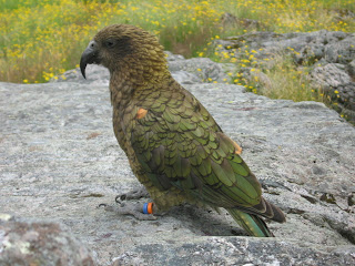 Nice lunch spot, then we followed a very narrow path up the hillside. Martin turned back but I continued, over a few precipitous areas, until the path ran out, with an excellent view of the upper part of the glacier and a lovely waterfall.
It was my turn to drive back along the horrible dirt road, but speed did the trick! The car was happier over the surface and Martin even managed to sleep, woken by a jolt as I hit a hole in the road - oops! Today we learnt that 'cattle grids' are 'cattle stops'.
The evening has been spent outside, over a dinner of garlic mussel salad washed down with a bottle of Marlborough Chardonnay, hence the rambling. The overcast sky has cleared this evening - blue skies prevail.
Will tomorrow be 'Sky Dive Day'?
 After half an hour, we're back on board to a sea with greater swell and an escape from the clouds of sandflies. Still many kilometres from the sea, the swell, together with the mushroom clouds, indicates bad weather on the way but we return safely, with winds only just strong enough to enable us to sail. Sailing is done with two kayaks side by side, front paddlers holding the bottom corners of the sail and keeping the boats together, those in the rear holding the rigging high aloft, fastened to their paddles. When the wind dies, one of the front paddlers gets covered in a wet sail!
 Unfortunately for us, the waterfalls weren't at their best, since, instead of having the usual 2 out of every 3 days with rain, they had experienced only one day's rain in the last 14! At Anita Bay, on the edge of the Tasman sea, the yacht anchored and some of us went sea kayaking whilst others went out on a launch (this included Martin who saw a rare fiordland crested penguin). Dinner was served on board before we motored back to Harrison Cove, seeing bottle-nosed dolphins on the way who were playing with a large eel, to spend a very comfortable night. The crowd were not party animals after all!
 Saturday
 We spent that time brewing, lunching, chatting to others and watching the cloud inversion slowly and completely disappear.
  Superb views along the Hollyford valley, all the way out to Martin's Bay on the coast, and across to glacier-draped mountains. Finally drag ourselves away to return to the Saddle, then a 3-hour belvedere walk at around 1200m, before dropping to the excellent Lake MacKenzie Hut. But the lake was too cold, even for Sue to wash in (Ed - but I paddled!).
 Very Scottish scenery apart from the trees. Fine views, briefly, as we motored along a board walk before entering more, less aggressive, trees for the pleasant descent to Upper Caples Hut. This hut has no resident warden. Ten occupants of diverse origin, some communicating better than others, spent a happy evening here before bedtime at sunset (around 9.30pm) as usual.
 Now, we're back at Kinloch Lodge where their hot tub has been enjoyed, with its views over the head of Lake Wakatipu and the mountains. It looks more like the sea, with waves crashing into the beach nearby, due to the brisk wind. The wind is useful - our washing is drying and there are fewer sandflies!