
Note that if you click on an image (PC or tablet) you get access to a slideshow that shows the
images in a better light and eliminates the need to put up with my wittering commentary
This was a 'Ramsoc' weekend with Sue's University contemporaries. Eighteen of us assembled at Langdon Beck youth hostel on Friday evening. Saturday morning brought a lie-in and a very leisurely start due to driving rain.
Departure was eventually fixed for around 11 o'clock, at which point, having seen us all dressed for the weather, the rain ceased to fall.

Most of those present went on a nine mile circular walk to Cow Green and Cauldron Snout, returning beside the River Tees, with just Neal opting for a visit to the museum at Bowes. Pete and Mary were on their eTandem, and I was on my old Shogun Trailbreaker mountain bike. (Still unable to walk far due to Plantar Fasciitis.)
The walkers set off first and 'sold a dummy' to an anxious lady the other side of a ford at Langdon Beck hamlet. No, it wouldn't be wise to cross here!

The walkers were soon passed by the eTandem, heading up the steady gradient to Cow Green.

Well, I wasn't there yet, but it would appear that the tandem paused for a group photo.

Meanwhile, having set off and then returned to base to collect waterproofs (which were not needed), I pedaled along the road to Langdon Beck hamlet, and watched the waters of Harwood Beck flowing under the bridge that serves as a sensible alternative to the aforementioned ford.
The walkers were soon passed by the eTandem, heading up the steady gradient to Cow Green.
Meanwhile, having set off and then returned to base to collect waterproofs (which were not needed), I pedaled along the road to Langdon Beck hamlet, and watched the waters of Harwood Beck flowing under the bridge that serves as a sensible alternative to the aforementioned ford.


I carried on to the car park, near where I got a view of the rather depleted reservoir.


The road to the dam stretched ahead. I was pleased to be on my bike rather than be walking along the tarmac.

The overnight rain was trying hard to replenish the reservoir.


The grassy slope to the left of the next picture provided an interesting (very slithery) descent.

I soon joined Pete and Mary, shivering under their tarp but looking happy enough.

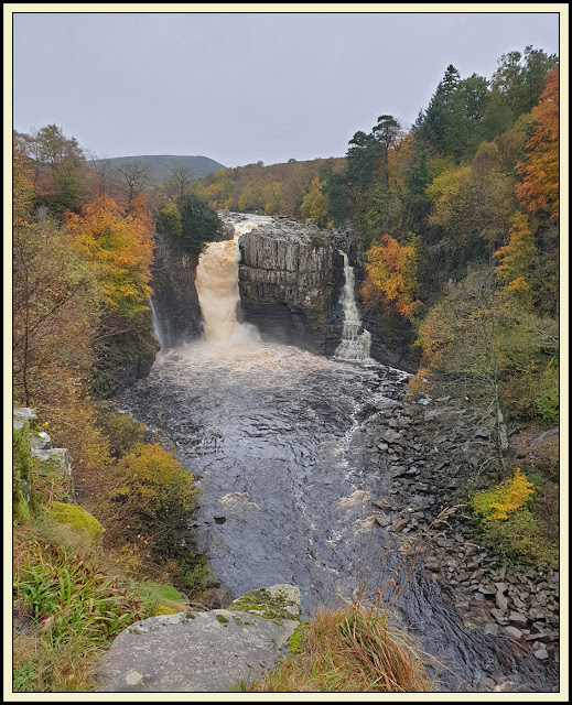
The other foot soldiers soon arrived, and we moved down to a good picnic spot in view of the Cauldron Snout waterfall. The next few images of views at Cauldron Snout were taken by various people and may not be in order. It's a magical place.


There was a brief shower of rain, during which I sheltered in an old barn, having headed off towards Birkdale.


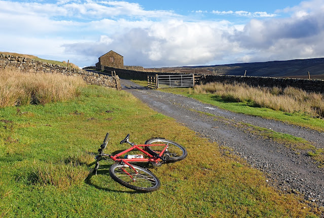
Here's my view towards Birkdale. I soon realised that in order to follow my desired route along a bridleway to Holwick, I'd have to cross Maize Beck. That clearly wasn't possible, so I turned round and headed back to Cow Green.


Can you see them in my picture, littered at the foot of the descent.

It's rough going down there, and though I wasn't there I wasn't surprised to hear of some 'stumbles', thankfully not requiring 'rescue'.


A lovely green lane led to Harwood, and another crossing of the beck there.


I got back at around 3:30 pm after a 4 hour outing, a few minutes ahead of the walkers, who told me they had walked a 9 mile circuit.
By the end of the day my tyres had wheeled their way over 37 km (23 miles), with about 500 metres ascent. Here's my Garmin 'track'. Click on it for a better image.


There was a fair amount of water coming over Low Force, though I'd hesitate to describe it as being 'in spate'.


The local fire brigade were out, practicing their river rescue techniques. (Elsewhere in the country, other teams were engaged in the real thing, with some paddle boarders losing their lives.)


Some went to Bowlees Visitor Centre for refreshments. Sue and I went home, stopping for a picnic lunch in a sunny spot on the high road to Brough, before enduring more heavy rain on the M6 nearly all the way home.
An excellent weekend, and thanks go to Alison, Sue W, Sue B and Tom, whose photos have enhanced this posting.
No comments:
Post a Comment