The main purpose of this blog is to keep in touch with friends and family, and maybe entertain others with common interests, particularly in relation to the outdoors. We hope you enjoy it, and your comments are valued....
Sue and Martin in Mallorca 2019
On the Archduke's Path in Mallorca
Saturday, 16 November 2013
Friday 15 November 2013 - Mynydd Mawr and Moel Tryfan
Thursday, 14 November 2013
Thursday 14 November 2013 - Moel-y-gest (262 metres)
Wednesday 13 November - The Great Outdoors Awards 2013
Wednesday 13 November 2013 - Moel y Dyniewyd
Tuesday, 12 November 2013
Tuesday 12 November 2013 (pm) - Manod Mawr
Tuesday 12 November 2013 (am) - Allt-fawr - 698 metres
Monday, 11 November 2013
A Wet Day in Porthmadog
Sunday, 10 November 2013
A Pyrenean Adventure – The Book
My first book is out, thanks largely to TGO Challenger Humphrey Weightman, who I discovered on my return from the Pyrenees had re-formatted this blog into book form.
The very limited print run arrived on 31 October, when a small ‘launch party’ was held with a few friends, several fizzy bottles, and a huge carrot cake.
I’ve sent copies to many of the people we met along the way, and we received this lovely response from Yolaine, Pierre, Chantal and JoĂ«l in Annecy. Wonderful.
The book is available by emailing me at martin@topwalks.com.
Prices are as follows:
Hand delivery - £10.00
UK + P&P - £12.00
Europe + P&P - £15.70
USA etc + P&P - £18.00
Anyone who buys a copy may also have a pdf version, and if you want just the pdf version the price is £5.00. Payment is currently by cheque or bank transfer, but I plan also to set up a Paypal account. (When we get back from a week away.)
Currently I’m aware of just one review, here – from Andy Howell. In fact, I rather like that review, so whilst the link verifies its efficacy, I’m reiterating it below:
Review: A Pyrenean Adventure, Martin Banfield
The growth of the internet and low cost digital technology has seen an explosion in ‘self publishing’ over the last decade. I’ve reviewed a number of self-published books here and a few of them have gone on to be very popular. In all honesty, I do receive some pretty dreadful, self-published, books but this one, my friends, is a little gem.Martin Banfield is a friend of mine, fellow blogger, hill walker, Pyrenean aficionado and TGO Challenger. This summer Martin walked the full length of the GR10, the long distance footpath on the French side of the Pyrenees. For much of the walk he was accompanied by his wife Sue and on other occasions his walking companions were a mixture of old and new friends; one of the great things about trails such as these is that you make many new friends as you walk.
Martin blogs as he walks, something that I have never been comfortable at doing. At the end of each day he sits down and writes his journal on his smartphone. When he has a phone signal he turns his trail prose into blog posts, enhancing them with the photographs that he has taken on that very same smartphone. The result of this technique is that the walking experience is shared with friends — real and virtual — in almost real time.
The further Martin walked this summer the more this blog became a shared journey. Regular contributors added to the fun and humour of the trip and others who dipped in and out clearly took inspiration from Martin’s walk.
As the walk progressed I remember writing a post here describing Martin’s journal as one of the best, current, reads on the net. Reading this now is a reminder of how right that observation was! Another fan of Martin’s walk was another TGO Challenger and print designer Humphrey Weightman. Humphrey was fascinated by what he saw emerging from Martin’s blog and decided that it would work — posts, reader comments and all — as a book. Humphrey knocked up some drafts and dummies and when Martin returned from France he found these proofs waiting for him at home.
The two of them decided that the experiment had worked and over a few weeks Martin tidied up the text a little and spent a little time processing his photographs. Humphrey then laid down the page design, commissioned printers and — hey presto — this book was born.
The book takes the form of an A4, bound, soft cover. The larger A4 format works really well allowing most of the day entries and the accompanying photos and reader comments to sit on one page. I can’t remember a blog — comments and all — laid out like this before, but the formula really works. This is a more polished version of the blog (still available online) but the text has lost none of its spontaneity, vibrancy and humour.
The many photographs that illustrate the adventure are well composed and provide readers with a real insight as to how these mountains look and work. The quality of the photographs are quite remarkable given that they were composed on a smartphone. But it is in the reading that this book delights. It is a real account of a real walk, not an account of great heroics or death defying stunts, but the kind of experience that is well within the reach of all of us.
If you are thinking of walking in the Pyrenees — planning anything from a full traverse to a week’s leisurely rambling — this book will give you a very good idea of what to expect. Writer Kev Reynolds has recently said (in his new collection of memories from a life of mountain walking) the more he reflects on his adventures the more he recognises that great trips are made up of encounters with people and not just the appreciation of the sheer beauty of the landscape. Martin captures this trail comradeship really well here. We meet many new people along the trail and share with Martin his joy of meeting them again a little further on. There are some lovely vignettes of the town and villages along the trail and stories of wonderful hospitality received from Inns and mountain hotels along the way.
The trail is illuminated well as you would expect but Martin also shares with us the look and feel of the villages in which he stays to resupply and take a break. There is humour and quirkiness here, not least in Martin’s sub project to document the variety of tractors that are found along the Pyrenean ridge.
Over the last few years Steve Cracknell has had some success with his own account his walk along the GR10 (If Only You Walk Long Enough) and I’ve no doubt that Martin’s book delight many in the same way. The idea to publish the text and the comments is a master stroke as, if you missed the trek at the time, you can still share the adventure as it evolved while also experiencing the banter between Martin and those who were following the trip.
I know many of you still appreciate the look and feel of the printed book and that many of you are happy hunting down titles from specialist shops and suppliers. To get hold of a copy email Martin directly at: martin@topwalks.com
The book costs £12 and this includes post and packaging. European delivery costs £15.70 and shipping to USA and other international destinations will cost £18. Martin accepts payment by cheque or bank transfer. Anyone who buys a copy of the book will also be given a PDF version for their ereader if they request it. The initial print run is limited — so get in quickly! This is a lovely, lovely book that will sit well in any personal library of mountain literature.
Just that one review makes it all worth while! Thanks Andy.
Friday 8 November 2013 – Rivington’s Towers
I organise a monthly (or so) evening walk. They aren’t particularly popular, but they get me out and I enjoy them, so who cares?
Anyway, we were down at Wythenshawe Parkrun one sunny morning earlier this year, when some assembled youngsters and enthusiastic parents cajoled me into arranging an extra walk in addition to the traditional Christmas stroll up Shutlingsloe (coming up on 17 December).
Rivington Pike was duly chosen, and the circular walk from the Barn to the Pigeon Tower and Rivington Tower has been reported on these pages before, for example here.
It’s an easy 4 mile stroll, taking about an hour and a half.
Tonight it was raining. Quite hard at times. The youngsters’ enthusiasm, and that of their parents, had waned or been forgotten. So it was just Sue and I who set off past the hall, pictured above, for something of a splodge.
My waterproof camera did come in handy for the following two pictures, from which you may gather it was a little damp up at Rivington Tower.
At least we weren’t in cloud – you can see the mast on Winter Hill through the rain. Sue was actually very happy – she had needed to unchain herself from her desk.
A refreshing outing, though we did feel the wimpy children had made a good call as they may not have enjoyed the slippery rocks and deep puddles…
Monday 4 November 2013 – In Search of the River Medlock
Some considerable time ago I volunteered to lead one East Lancashire LDWA’s Wednesday walks. Since it was to be on 20 November I chose what I hoped would be an easyish route, given the requirement to make it 15 to 16 miles.
So how about Stretford to Oldham? I called it a ‘Medlock Meander’. Details are here – this link may disappear after 20 November.
Anyway, I thought I’d better do a recce, so I set off in lovely weather in search of the River. Before that, the Bridgewater Canal threw a curved ball at me after I failed to notice a diversion sign. It’s a good job the extra 2+ km that resulted was alone and not with an angry group of walkers!
The canal led me through Manchester (taking great care to follow the Ashton Canal and not the one to Rochdale), past City’s football stadium to Philips Park, where at last I found the River Medlock. In a culvert.
From here it was a very pleasant walk to Oldham, although after various mistakes and diversions I managed to cover nearly 32 km, which I fear is more like 20 miles than 15 miles!
It’ll be ‘alright on the night’, as they say.
A Big Birthday Party
Last Friday, 1 November, saw us in Tewkesbury celebrating Julia’s (pictured on the left above, with her friend Liz on the right) 80th birthday. Congratulations Julia.
We should see more of Julia in the Dolomites next summer. We met on my first trip to the Himalayas in 1997.
We were also celebrating Julia’s granddaughter’s 18th birthday. Megan is pictured below, sitting on my left, whilst to my right is Liz’s husband Dave, who has kindly sent me a couple of videos – ‘The Longest Climb’ that I’ll enjoy watching when I have a couple of hours free. Thanks Dave.
Megan won’t be joining us in the Dolomites, though she loves the Via Ferrata routes, as she has now flown to Sydney for a year in Australia(ish) before she goes to Manchester University, when we hope she will call in for the occasional Sunday dinner.
Not forgetting, it was also Megan’s dad Ian’s 50th birthday. Ian is pictured below with his younger daughter Lexi, and he confirmed that reaching the advanced age of 50 has made him no less voluble! Sorry Ian! He’s too busy at work to come to the Dolomites next summer. A shame.
Sue and Caroline were also there, but they must have been taking the pictures. It was a lovely evening, all too short.
We hope to see you all again soon, and wish Megan well in Australia.
A Walk in the Clouds – Fifty Years Among the Mountains – Kev Reynolds
This is a lovely book, in which mountain guidebook guru Kev Reynolds relates 75 short stories covering a few of his more memorable experiences in the Alps, Pyrenees, Himalayas and elsewhere.
It’s a delightful and very easy book to read, with skilfully composed prose and a real feeling for the scenarios portrayed.
When I finished reading it I wanted to start again from the beginning.
Strongly recommended for a Christmas list or an immediate click on the £12.95 button on this link.
Saturday, 9 November 2013
Wednesday 30 October 2013 – A Plod from Adlington to Abbey Village (featuring Fish ‘n Chips and a Quagmire)
It’s some time since I went on a proper ‘Plodder’ walk, apart from that nice excursion to the Roaches with Don and Neil, having spent the time since Part 1 of the Thirlmere Way on 3 April in a variety of alternative locations or states of injury.
Having missed many of Reg’s previous ‘Fish ‘n Chip’ outings, I made sure I didn’t slip up this time. We started from Kingston Towers in Adlington at 10am prompt, with twelve stalwart plodders and a couple of dogs.
Lapsed LDWA member Alan R had been tuned in to my wavelength and turned up in search of tractors, or was it by way of therapy after some Satmap GPS software mishaps and the mess of a dysfunctional continuous ink supply system?
Anyway, Reg came up trumps when he led the obedient group out of his housing estate and more or less immediately past a David Brown 1390 2wd tractor in condition that had Alan R drooling.
Pleasant paths and lanes led inexorably across the M61 motorway and on towards the banks of Anglezarke Reservoir, with good views to Winter Hill and Rivington Pike.
A pause for breath outside a new housing estate offered Reg the chance to explain that this was the site of Heath Charnock Isolation Hospital.
Here infectious diseases such as tuberculosis were treated between 1901 and 1982. Patients benefited from the clean air, there being no nearby motorway for most of that time. The hospital was demolished, making way for this de-luxe housing estate with a constant hum from traffic, in the mid 1990s.
The infant River Yarrow was crossed by a narrow footbridge, beyond which we enjoyed excellent views towards Anglezarke Moor.
The path beside Anglezarke Reservoir is a public right of way, despite the landowner’s efforts to discourage visitors.
The green lane deteriorated into a minor road leading towards Heapey and the disused railway line. Reg related stories about secret storage depots for retired steam engines. There’s much more about it here. There are rumours of night time visits by large lorries, ‘disused’ tunnels guarded by CCTV, locals who maintain a discreet silence, and much more.
An assortment of paths and tracks led us past disused railways, notably the Lancashire Union Railway, sometimes completely overgrown, sometimes converted to nice pathways on private land like the one shown below, and just occasionally on public rights of way where we could enjoy a stroll along the track bed.
Then we crossed a few muddy fields and passed beneath lovely autumnal tree canopies.
A large pond, with voracious ducks, signalled our entry to the village of Brinscall.
Lunch beckoned. Reg had warned the fish ‘n chip shop of the impending arrival of twelve hungry walkers, and we were soon ensconced on the pond side of a wrought iron ‘snake gate’ in a nearby park, with excellent portions of said fayre at just £3.80 a portion.
Plodder stops are fairly short, but thankfully longer than the regular LDWA lunch breaks, so we managed a good twenty minutes of relaxation before setting off on the last stage of today’s journey to Abbey Village. Much of this was on the track bed of the Lancashire and Yorkshire railway branch of the Lancashire Union Railway, linking Cherry Tree with Chorley. The seven mile stretch of line served mainly to transport coal from Wigan to the mills of East Lancashire without having to go through Preston, and it lasted from about 1869 to 1968. There are quite a few remains (platform, bridges, etc) at Withnell, which we passed through en route to Abbey Village.
The remains of a narrow gauge model railway lay below us at one point, unused since the death of its enthusiastic owner several years ago. A great shame.
Having reached Abbey Village, our destination, Reg decided we were either too early or not muddy enough. So he led us into a farmyard where even those with boots discovered the inundating effect of deep slurry. The farmer’s tractor was a bit of a give-away – it was armed with two sets of rear wheels. The field we were ushered innocently into was a trap. Luckily there was no bull, but only three or four of us managed to escape over a barbed wire fence to the safety of a back alley. The rest circled aimlessly in the field until released by Reg, who had noticed that the bus to Chorley was now due. Last time we caught this bus it had been distressingly early for those who had just purchased a beer. Today, fortunately, it was on time. This was perhaps due to the cautious driver, who nevertheless caused quite a commotion when he braked sharply to avoid a pheasant.
Here’s our route – 16 km, 250 metres ascent, in 4 hours. A grand day out.
There are a few more pictures here. And Alan R’s excellent report is here.
Friday, 8 November 2013
The Munro Society – Anniversary Anthology 2002-2012
I was delighted to receive the other day this lovely volume from The Munro Society, especially as it includes some of my own work. I’ll reproduce that in due course on these pages, but for the moment I’m trying hard to catch up with a backlog of postings.
The Munro Society was formed in 2002 and has done much good work in promoting the Munros, reviewing some of their heights, and producing voluminous environmental data.
It’s objectives are set out as follows:
- To secure access to and conservation of Munros as areas of wild mountain land.
- To foster social and cultural exchange between members.
- To establish and maintain an archive of material relative to the Munros and Munroists.
This 177 page A5 volume falls within the second and third objectives and is a labour of love on the part of Julian Foot, who has compiled the anthology from an assortment of narratives from members who between them re-climbed every Munro during 2012. The styles of the numerous contributors vary greatly, and each entry is limited to about five hundred words, so you shouldn’t get too bored, though I don’t think many, if any, of the contributors are professional writers.
It’s not a guide book, just a lovely selection of stories. I’ve dipped into it and will enjoy reading the rest of it shortly.
Well done, Julian.
Whilst Munro Society members will have received their copies, further copies are available, as detailed here.
Ramsoc Weekend at Eyam – 26/27 October 2013
This is the sixth Ramsoc weekend to be mentioned in these pages – Sue’s University Rambling Club reunion has come round again. This year she inherited the organiser’s mantle from Sue W, who retired after a twelve year stint but remained in a crucial position as she bankrolled the whole event. Thanks Sue.
Click here to view all the Ramsoc postings.
Saturday
We assembled outside the impressive if rather crumbly facade of Eyam Youth Hostel.
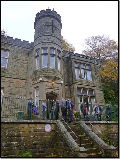
24 out of the 43 attendees set off in one group, past a large ball of wool. Was it a sheep, a llama, or an alpaca? (See slideshow for images)
Once in Eyam village, the group stood outside a closed cafĂ© – showing a bizarre reluctance to follow their leader across the road!
The day’s first geocache - 'A Stoney stroll part 7 through the plague village', was easily located by resident expert Tom (aka HoratioP), ably assisted by David (aka david1.7).
Here Kate and Andrew rather fail to suppress their bafflement that folk leave tupperware boxes with log books scattered around the countryside.
The second cache was found further on along the path to Stoney Middleton, near here - the boundary stone where in 1666 the quarantined villagers placed their money to pay for the food that was left for them in the time of the plague.
'HoratioP', ‘Phreerunner’ and 'david1.7' recorded their visits, and down in the village ‘The Grove’ soon revealed our third cache of the day.
Meanwhile, Sue busied herself with autumnal pictures like this one.
Cache number 4 (‘Rocket’) just outside Stoney Middleton provided an excuse for another pause, before we headed over the top to Coombs Dale, passing a cache – ‘A Quarry Caper Pt 1’ - that had been ‘Muggled’ (evidenced by a bare strip of velcro) and another well hidden cache, ‘A Quarry Caper Pt 2’, our fifth find of the day. Others enjoyed some tea and cake whilst the geocachers sought this one out.
After finding ‘A Quarry Caper Pt 3 – Big Log’, we continued along the track up Rough Side that was almost inundated by a stream emanating from a forceful gurgle beside the path, guarded by a small but perfectly formed frog.
After a short pull onto Longstone Moor, cache number 7 – ‘A Quarry Caper Pt 9 - Pond the Replay’ – was soon located under some rocks. [What happened to Pts 4 to 8? I have no idea!] Moving on towards Wardlow we passed a brightly coloured pond where many seagulls were braving the chemicals and there were dire warnings of ‘Thin Ice’. There is much evidence here of the area’s past history of mining of various minerals.
Lunch was taken on Longstone Moor, in the shelter of a well grassed spoil heap.
Returning to face the fresh breeze, we paused by old mine shafts to take in the view by our next cache – ‘Take in the View’, before descending through Wardlow and down to Tansley Dale.
We came across some familiar figures, identified from afar by way of a rather overdressed, but admittedly less scruffy than usual, gent in a stalking hat. It was Sue W’s group, on a similar route, but aiming for pub stops rather than geocache pauses.
We waved them off towards Litton and headed past Peter’s Stone towards the delights of the Three Stags Heads inn at Wardlow Mires.
In bright sunshine, we found our next two caches – ‘Beyond Peter’s Stone’ and C.O.D. Petrus (Derbyshire) – the latter being almost at the top of Peter’s Stone, from where the image at the head of this posting was taken.
Peter’s Stone is seen here as the distinctive feature on the left of the valley, looking back from the path to Wardlow Mires in the shade of the valley.
Tom then found geocache number 11 - only revealed to 'Premium' members like HoratioP, so Phreerunner and david1.7 were unable to record this one, though we did sign the log and note the superb hiding place.
Whilst some bravely sought beer in the cramped surroundings of the Three Stags Heads, and in the company of various other dead animals secreted as good luck charms within the inn’s walls, others continued to Foolow, and many more enjoyed a caffeine fix at the Yondermann CafĂ©.
Then it fell to Tom to find 'A Silly Cache'...
... from where there's a view down Silly Dale.
Luckily, Tom had found the cache before David, a member of Sue W’s now well-oiled group, selected its position for his 'call of nature'.
Soon our rather diminished little band reached the duck heaven that graces the pretty village of Foolow.
Cache number 13 – ‘Foolow’ – was soon discovered by resident expert Tom, but its clever concealment – “a small camo style cache with a micro inside it … stealth may be required” – may well have fooled the rest of us for some time.
The path continued across fields towards Eyam, with late afternoon views to Eyam Edge and a failure to find the ‘Foolow Bound’ cache, which it later transpired had gone and has subsequently been replaced.
As we returned through Eyam, Hall Hill Troughs became the site of our 14th and final cache of the day - another Premium cache available only to HoratioP (aka Tom) to record his visit on the geocaching website.
The Youth Hostel is a little out of town. It was a pleasant walk up the sunlit road. I was alone, having now managed to ‘lose’ all 23 of my charges!
Everyone turned up eventually, and the hostel meal was fine. After the previous night’s poorly attended ‘Pyrenean Adventure’ slideshow, tonight’s offering of ‘An Hour in Knoydart’ filled the room to bursting point, mainly with people who had been on that trip and had the stamina to view the 900 or so pictures.
Today's route is shown below - 20 km, 450 metres ascent, 7 hours, 14 geocaches.
Sunday
We assembled in the car park for a circular walk/bike ride.
“Any chance of a lift on your crossbar?” the finely honed athlete asked the portly gent in the cycle helmet.
Today’s route, led by local guide Sue W, took us back past the puzzled sheep with a long neck and down to Eyam, where the Miners Arms was proposed as a possibly suitable venue for a future Christmas lunch.
The road past the Wesleyan Reform Chapel, built in 1787 when John Wesley was still alive, led to the Riley Graves, where Mrs Elizabeth Hancock buried her husband and six children, victims of the plague, between the 3rd and the 10th of August 1666. The Hancocks farmed the field, known as Riley’s field – ‘Riley’ comes from ‘Rois Ley’s’ which means ‘Kings Field’. It was part of William the Conqueror’s Royal Hunting Ground.
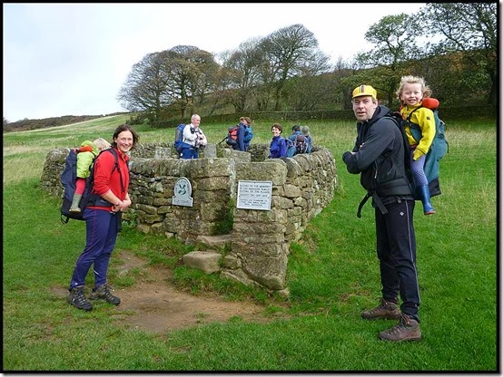
Then we marched off through pleasant woodland towards Froggatt and the River Derwent.
The Derwent Valley is very well signposted hereabouts, though the drainage is a bit suspect.
We lunched outside the very posh Hazelford Hall, where a resident arrived in a chauffeur driven carriage whilst we admired the views towards Hathersage and Stanage Edge from the perimeter of her garden.
Heading on towards Abney Clough, Sue found this curious item.
Sir William Hill - 429 metres, fell to a splinter group comprising just one person, whilst everyone else hastened back to Eyam in a race with the predicted storm, involving winds up to 100 mph and other dire warnings.
It did look a bit threatening…
Our route today is shown below - 16 km, 450 metres ascent, in 5 hours.
All in all a most enjoyable weekend in surprisingly fair weather. Thanks go to the Sues for making it happen, and I must thank Tom for his expert assistance in tracking down Saturday’s geocaches.
A 95 image slideshow, probably only of interest to those who were there, is here.


