 We don’t have a ‘Mountain View’ here in Timperley, but occasionally we do enjoy a nice sunset whilst scoffing our dinner…
Sue and Martin in Mallorca 2019

On the Archduke's Path in Mallorca
Friday, 19 October 2012
Sunset in Timperley
We don’t have a ‘Mountain View’ here in Timperley, but occasionally we do enjoy a nice sunset whilst scoffing our dinner…


Wednesday 17 October 2012 – Around Glazebury

Itchy feet on a sunny afternoon drew me to explore a few red dots on Explorer Map number 276.
It’s a short drive from Timperley to the village of Glazebury, where the Raven Inn’s car park has plenty of space for customers.
From the Raven Inn, I headed down Heyshoot Lane and after a few metres turned left along Moss Lane. A path to the left after 300m took me over a stile and into a slightly wet field, leading to Light Oaks.
Beyond the farm, a left turn leads past the lovely old building that is Light Oaks Hall, whose history apparently dates back at least as far as the 14th century, though the current building dates back only to early C17.

Crossing the bridge over Glaze Brook, I re-entered Cheshire, after having paid brief visits to both Greater Manchester (Salford) and Lancashire (Wigan).

A right turn at the main road took me past the Chat Moss Hotel. The hotel is adjacent to the world’s first timetabled inter-city passenger railway. The Liverpool and Manchester railway was opened in 1830 by the Duke of Wellington, and one of the world’s first railway booking offices was on the premises of the hotel that formed part of what used to be Bury Lane Station.
Continuing under the railway bridge I arrived at the C of E parish church - All Saints, Glazebury.

A left turn down Hurst Lane leads to a health conscious farm where visitors have to dunk themselves in chemicals before entering.
Amongst the farm buildings stands Hurst Hall, built around 1700. It was originally the residence of the Holcroft family, a branch of the de Culcheth family, who were Protestants, and therefore Parliamentarians in the Civil War. The Holcroft family also enjoyed notoriety for a scandal involving the daughter of Lt-Col John Holcroft, an officer in Cromwell's army. His daughter, Maria, married Irishman Lieutenant Thomas Blood in 1650 in nearby Newchurch before moving back to Ireland. He was later to be promoted to the rank of Captain. Captain Blood then gained notoriety for devising a plot to steal the Crown Jewels from the Tower of London and using them as a ransom for Charles II.
A thin path rich with either disinfectant or rainwater (it was hard to tell!) led me around the left perimeter of the farmyard, soon reaching a pedestrian crossing across the line that was used in the Rainhill trials in 1829. Stephenson’s Rocket now features in the Chat Moss pub sign, as shown above. It was easy today to dodge the Arriva trains that nowadays service the route.
Suddenly, a thunderstorm arrived to interrupt a sunny afternoon; shame I’d not got waterproofs with me!
My old Keen trail shoes had their waterproof lining tested yet again, as I took a left and immediate right after the crossing, past a lone beech tree to a path junction for a right turn through wet ground to a small footbridge, then bearing left down a flooded path after which a series of left turns brought me back to the Raven Inn, past hedgerows that were just about gaining an autumn tinge.


Here's the route - just a brief dose of fresh air spiced with disinfectant on an October afternoon - it can be easily extended (see Explorer Map 276).

There’s a short slide show (17 images) here.
Tuesday, 16 October 2012
Sunday 14 October 2012 - The Calderdale Mountain Bike Marathon (CMBM)

This blog passed its fifth birthday unnoticed, in a flurry of Marilyn Bagging activity with M2. I’ve now realised that fact, as this is my sixth report on the annual mountain biking event - CMBM.
The CMBM reports are all here, with route details and a results summary specifically here. The CMBM website is here. Next year’s event will be on Sunday 13 October 2013.
I was faced with a decision as to whether to use ‘Stumpy’, the full suspension bike I’ve had for over a year. The bike is fine, but on rough ground bits tend to fall off it. I could see that conditions would be very muddy, so I chose to take ‘Shogun’ on its 11th CMBM. ‘Shogun’ has closely fitting mudguards. Today that meant that my back stayed clean and dry, whereas most folk looked as if they were encountering severe bowel problems. In fact, a number of few riders politely enquired as to whether I was really taking part in the event, as I was pottered along in clean clothes on the bike that is so ancient that it sometimes gets ‘wow, a classic bike’ comments!
It was a beautiful day, starting with the scraping of thick frost from the car, then fog on the motorway, with mist gradually dissipating after the 9am start, where about 350 of us assembled in Bowood Lane near Sowerby Bridge.

Early sections of the ride weren’t any more muddy than usual, and it was disappointing to find that the rocky descent to Mytholmroyd has been ‘sanitised’, meaning there was no need for anyone to dismount on this previously tricky descent.
It’s a steep climb from New Bridge to the second support point, where I stopped for a while this year. The picture below demonstrates the brilliant performance of those at the support points. Whilst some riders take a break like I did, many just keep going, taking drinks and food from the supporters without needing to dismount. There’s no need to carry a map, as all the significant turns are both signed and in most cases are manned by marshalls. The aim of the event is to present a personal mountain biking challenge, at the same time raising funds for the local Scout group. This year there were two other events taking place on the same day over different routes. We were told to ignore the yellow signs!

After Walshaw Hamlet there’s a steepish climb up to Shackleton Knoll. This year the surface was so slithery that I didn’t see anyone managing the ascent without needing to dismount, though I’m sure the leaders managed fine. Here’s Scott Oddy near the top of the hill, where the gradient eases.

Looking back down the hill, many of those in the picture are walking up the steeper sections, where the ground this year was too smooth and slippery to gain traction.

After this there’s a long bumpy descent – one of the sections where Shogun’s lack of suspension means that I’m comparatively slow compared with most riders. Then, after a pleasant road section, comes the crux of the ride, the moorland crossing culminating in the technical descent from Midgley Moor, where most of the event photos are taken. Click here (for a limited period) if you want to view images of bikers in all manner of weird positions and thoroughly coated in mud. Robert and I look relatively sensible compared with many others!
Whilst neither Robert nor I fell off, we found it very difficult to avoid the foot deep slurry of peaty puddles across the moor. The waterproof lining in my well used Keen trail shoes (see footnote) proved to be up to the job, combined with close fitting ankle gaiters, and my feet stayed comfortably dry, albeit coated in slurry from a misjudged pond crossing.
It was a particularly tiring morning, and for the first time in eleven years, albeit with nobody in sight behind me, I walked up the start of the steep hill to the finish. In fact, I followed a large group who were all also walking. But I finished in the saddle…

Then it was into the routine of enjoying some tea and soup, collecting the t-shirt and finisher’s certificate (and this year a Thank You card ‘In appreciation of your support over 10 entries of the CMBM’), throwing the bike into the back of the car, a quick change, and a celebratory beer with Robert at The Church Stile Inn, where we stood outside with our beers, cheering on the people still approaching the finish. In this case, Alistair Murphy.

As you can see, it remained a lovely day. Who says the weather is always bad in the UK? They are wrong.

Today’s Statistics:
Winner – 2 hrs 6 min – 332 finishers – slowest 5 hrs 35 min
Robert: 3 hrs 1 min – 88
Martin: 3 hrs 37 min – 183
Here’s the Garmin gadget version of the route:
A footwear note:
This year I used my Keen Targhee 11 Walking Shoes for the second time. These are now nearing the end of their days after 1400 km of walks and numerous bike rides. I used them together with close fitting ankle gaiters and Sealskinz socks which in the event weren’t needed, as the shoes and gaiters combined withstood the substantial barrage of water and slurry. My feet stayed perfectly dry. Robert witnessed the peeling off of the outer layers. So, more plaudits for these splendid Keen shoes.

Monday, 15 October 2012
Wednesday 10 October 2012 – A Poynton Plod

As well as being a Plodder, the inimitable Reg is also a Railway Rambler. It was one of the latter rambles that inspired him to plot this fascinating stroll, which at no point strayed more than 2 miles from its starting point.
We convened at Middlewood Station. It's in the middle of a wood! One other bemused passenger was directed towards the nearest road, as there is no vehicular access to the station.
This Convention of Plodders then posed for the above photograph. Given the aura of the out of place young man on the left of the photo, we have now all placed orders with the Rejuvenating Hat Company.
After a short walk along the Middlewood Way we arrived at Higher Poynton Station. One joker suggested that this would be an appropriate route for Don, a stalwart Plodder who often appears on these pages, as he would struggle to find somewhere to fall over. Reg decreed that this was not at all humourous and declared ten minutes silence over mugs of tea and a hefty dose of fudge brownies, in memory of Don’s ankle which was shattered last week by a slippery blade of grass on Pen-y-ghent. A report can be found here (you may need to scroll down to 3 October).
A nearby Visitor Centre provided a challenge for this myopic bunch of pensioners, for whom the information there, together with today’s closely typed six page handout from Reg, plus numerous information boards, left several Plodders searching for Information Overload tablets.
There's a pricey museum of industrial archeology (engines) nearby. It was shut. Reg gave a useful précis in lieu of a formal visit, whilst Allan posed by an exhibit.
We visited the sites of various pits, tramroads and railways, mainly built on private land so not requiring an Act of Parliament. There’s much more information on them here.
Our ramble involved walking up and down a series of tramroads and railway lines. These days they are leafy lanes close to affluent suburbs of Manchester, but as recently as the 1930’s both the railways and the horse-powered tramroads were still in limited use prior to the closure of the last of the collieries.
Lunch was taken at a garden centre where a miniature railway must attract huge numbers of weekend visitors. It was busy today even though the railway wasn’t operating (despite evidence to the contrary within Reg’s slideshow!), despite Ann’s best efforts.
The walk continued through leafy suburbs with exuberant street furniture, before joining the Prince’s Incline. This led nearly all the way back to the Middlewood Way, where popular demand required Reg to lead us to a local fleshpot. The Boar’s Head duly met said ‘fleshpot’ criteria, where more brownies supplemented the beer.
Before we knew it we were back at Middlewood, where most of the others left on a train whilst I tried to navigate my way back to my car near High Lane.
There’s a short slideshow here.
Here's our route - see if you can follow the arrows! 15-16 km (10 miles) with about 140 metres ascent.

Here’s what my Garmin gadget made of the trip:
Reg’s more accurate report is here (scroll down).
PS I happen to be leading the next Plod, to which all readers are welcome. It’s on 31st October, with the highlight being a visit to Lud's Church. We will be starting at 10.30 from Danebridge (SJ 965 652). Take the A523 from Macclesfield towards Leek, turn L along the A54 towards Buxton, then after nearly 4 miles turn R to Wincle then Danebridge, where there's plenty of space to park on the roadside before the bridge.
The walk is about 11 miles, with no refreshment point - it's a circuit via Hanging Stone, the Roaches, and Lud's Church (a cave). Afterwards I'll be going to the Knot Inn in nearby Rushton Spencer for refreshments with anyone else who wants to come along.
Tuesday, 9 October 2012
The Cloud - Marilyn Number 1303

After refreshing ourselves at Rushton Spencer's excellent Knot Inn, we parked just north of Timbersbrook for this easy final circuit, taking the Gritstone Trail path to the summit and returning via the escarpment trods.
The late afternoon views were excellent, if a little hazy - Jodrell Bank, just eight miles away, was only just visible.
Then it was back to Little Italy (in Timperley).
All in all an excellent trip during which we appear to have bagged 5 Travelodges, 27 Marilyns and 1 'sub Marilyn' or HuMP (hill with a HUndred Metre Prominence). I now need to look for a pencil to mark up, and update, Alan Dawson's book.
I'm sure there's more to follow when I've downloaded some photos and the data from my Garmin Gadget.
Bye for now...
Sent using BlackBerry® from Orange
Gun - Marilyn Number 1227

There are plenty of parking spaces on the road around SJ 968 609, from where a ten minute stroll to the north leaves you in the vicinity of Gun's trig point, with fine views towards Shutlingsloe (pictured) and over the countryside of Staffordshire, Cheshire and Derbyshire, which three counties meet at nearby Three Shire Heads.
Sent using BlackBerry® from Orange
Mynydd Llangorse - Marilyn Number 954

A father and his young daughter romped down the hill towards us as we took a short break on some rocks by the cars. We thought perhaps they thought we were car thieves (such thefts are common in this area), but it turned out that the little girl was in a rush to get to a nearby indoor climbing wall as soon as it opened.
We saw nobody else on the hill as we rose past Harebells and Tormentil, and sadly over lovely turf that had suffered recent damage from trail bikes despite a 'No Bikes' sign at the foot of the hill. Such a shame for those who regularly try to appreciate this otherwise quiet and pretty countryside.
A trig point that we visited appeared to be lower than the pile of stones (pictured) that marks the summit area. As usual, we tramped around a bit to ensure that M2's Marilyn Bagger's 'tick' could be entered in his copy of Alan Dawson's book without any question or doubt.*
By then one of the layers of cloud had either risen or lowered to envelope us for the rest of this pleasant amble as we retraced our route back to the car, and another cuppa.
* I'm writing this having returned home and spotted some messages from another inveterate hill bagger, Mike Knipe, who has pointed out that the list of 'Marilyns', like the list of 'Munros' (Scottish mountains over 3000 feet high) is a dynamic thing, which changes as more accurate surveys are carried out. So Alan Dawson regularly updates his list. Consequently the 'original' numbers used in this series of postings are probably all now wrong, and Raw Head no longer meets the criteria for inclusion in the list. That doesn't of course stop it being a good walk though! Thanks Mike, and I hope you agree that whilst on one hand 'ticking' these lists of hills can become a little compulsive, they do without doubt provide a stimulus for us to visit different hills rather than deepen the grooves in just a few favourites. Certainly the variety afforded by this current trip has been remarkable.
Sent using BlackBerry® from Orange
Mynydd Troed - Marilyn Number 759

There's evidence of lots of pony trekking hereabouts, though we saw nobody engaged in that activity today. The hill was empty.
We made the walk into a pleasant circuit of around an hour by continuing down the hill's northern ramparts for a short while, before turning sharply to the WSW down a path that led to a good bridleway around the bottom of the hill and back to the car.
Sent using BlackBerry® from Orange
Sunday, 7 October 2012
Mynydd Carn-y-cefn - Marilyn Number 881

We concluded that signposts to Welsh antiquities must be compulsory, whereas there is no requirement for parking facilities or even access to such antiquities. Here, roadside boulders and 'No Vehicles' signs made the parking issue clear, whilst a snarling allocation made the access issue even more transparent.
After parking in a nearby bungalow road, we set off up an unsurfaced lane that soon wended its way through an empty golf course. Sticking obstinately to the lane, which eventually deteriorated into a steep trod up the hill, we continued relentlessly to the 550 metre summit. M2 sat dutifully on the rather uncomfortably eroded trig point, surrounded by views of Welsh valleys under high cloud that had rolled in to announce a change in the weather.
Continuing south east, we rejoined a vague path and descended steeply. The paths are marked better on the map than they are on the ground hereabouts (though they certainly exist), so the GPS came in handy. Thus we negotiated our way to a lane from which we could at least see the ancient Round Towers, but a close inspection proved impossible.
Sent using BlackBerry® from Orange
Fan Gyhirych - Marilyn Number 537

We'd seen some vehicles on the Land Rover track below Fan Gyhirych and wondered what they were doing. The track itself presents an ugly scar across the pristine hillside, but I'm sure it wasn't built for the paragliding enthusiasts who were using it today, so good luck to them.
On reaching a cairn near Fan Gyhirych's summit, we enjoyed our lunch in the company of a local couple, whilst watching the paragliders trying to make the best of a windless day. A couple took off, and proceeded to plummet like stones to the valley below, under the watchful eyes of chatty crows and defecating red kites (there's a feeding station nearby).
After half an hour at this lovely spot with fine views towards, inter alia, Titterstone Clee Hill, we adjourned for our now traditional (has anyone noticed? probably not) summit photo. It was my turn. This summit had a moat that reminded me of the bad old days at Black Hill!
Luckily, M2's 'Rules for Marilyn Baggers' tome required him to touch the trig point, so his boots also got a dunking.
After that we headed back east taking the least line of resistance, part of which involved a boggy path beside a wall to the north of Fan Nedd. M2 fell behind again; 'he's getting tired' I thought. It turned out that despite not having had to cross a fence he had contrived to rip his hand on some barbed wire. "Have you got a plaster?" he whimpered from above a pool of blood as I sat on a bench enjoying the last dregs of my flask of tea in view of .... Titterstone Clee Hill? That made me feel guilty about telling the Welshman with a can of Carling, with whom I'd had an interesting "where's the pub" "I don't know" encounter a little way up the hill, that my 'lazy companion back there only speaks Gaelic'. Luckily, there were no repercussions, and M2's hand injury was easily repaired.
Sent using BlackBerry® from Orange
Fan Nedd - Marilyn Number 670

Those simply wishing for a short stroll should budget about an hour, there and back from SN 923 196.
Incidentally, today we could see far out to sea to our south, and far into Shropshire and mid Wales to our north. I couldn't identify many individual distant hills, but from her perch on Titterstone Clee Hill (and perhaps Brown Clee as well - has she taken up Marilyn bagging?) Sue tells me that today the distinctive shapes of both Pen y Fan and Cadair Idris were clearly visible.
Shouldn't she be at home doing the housework?!
Sent using BlackBerry® from Orange
Fan Fawr - Marilyn Number 514
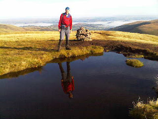
Today spring was again in the air and you can even see a cloud inversion (well, slowly dissipating morning mist) behind me in the summit photo.
I expect you've been up here as well, Alan, and I'd be surprised if you haven't managed some of (yes, you will finally be able to breathe a sigh of relief) tomorrow's final instalment of this series of postings.
On our descent from the scenic summit, with its resident pond for 'reflection photos', we paused to admire fine views including Pen y Fan. M2 stopped for a chat with a couple of chaps who'd been to Mera and Island Peaks, and I chatted for a while with a runner who was training for the OMM (a tough mountain orienteering event) which is taking place in the Howgills in a few weeks' time.
After an hour and twenty minutes on the hill we were back at the Storey Arms car park just in time to enjoy Denise's first brew of the day (£1 for a cup or can of anything) together with some complimentary shortbread. She told us all about her 'Storey Arms Refreshments' kiosk, from which she's been making her living for the last 22 years. She's been up Pen y Fan once - "just to see what it was like, since so many people ask that question".
Sent using BlackBerry® from Orange
Saturday, 6 October 2012
Pen y Fan - Marilyn Number 260

We had made our way slowly along the ridge from Waun Rydd, pausing to watch a paraglider soaring past - he finally landed in Cwm Oergwm, from where he proceeded to walk back up the hill.
Frequent chats with other walkers also punctuated our progress.
The crowds thinned once we got onto the flatter but less popular Craig Gwaun Taf ridge, for a final high level stroll before the sharp descent to the lower of the Neuadd reservoirs, which were full today.
A pleasant stroll on good tracks then led back to the car park at SO 027 178, from which point The Red Cow Inn's Wye Valley bitter was mercifully nearby.
Sent using BlackBerry® from Orange
Waun Rydd - Marilyn Number 452

There were lots of people about on this sunny summery day - perfect weather for walking.
On reaching the northern escarpment we headed north east to a small pile of stones that marks the summit of Waun Rydd, with fine views over the Brecon Beacons and in all other directions on this perfectly clear day once the early morning mist had dissipated. Those camping overnight up here must have enjoyed some fine inversions.
We trudged to and fro to a grassy area that looked higher but wasn't. You could easily return to the car park from here, probably taking less than two hours for the return trip. We chose to make a day of it by carrying on along the ridge.
Sent using BlackBerry® from Orange
Bryn Bach Parkrun (not a Marilyn)

They are not addictive....
Today's 5km Parkrun venue for M1 was planned with M2's Marilyn bagging addiction in mind, as it was en route to several such hills. However, M2's interest in the Parkrun concept lies several octaves below zero, and being unable to handle the idea of a half hour break in the journey whilst M1 parkran, he elected to forgo a walk in favour of a Saturday morning lie in!
He was only just about out of bed when M1 returned at 9.45!
Sent using BlackBerry® from Orange
Friday, 5 October 2012
Rhiw Gwraidd - Marilyn Number 1122

At SO 010 645 a signed path leads through the woods. But it doesn't. It takes the unwary Marilyn bagger on a unique jungle experience, almost within sight of a nearby forestry track. We eventually decided that the only way of reaching the security of this track was to retrace our steps to where we'd left it in the first place!
A bit further on we came to a hairpin bend from where we could access a field through undergrowth and over a barbed fence. We should have noted more carefully where we entered the field, as this seemingly minor lapse afforded us another jungle experience, featuring a new species - the Himalayan Bramble - on our return journey.
In the meantime we slogged up a steep field, past glissading sheep, to reach, over more rippingly vicious wire, the stunningly unspectacular summit that nevertheless enjoyed good views of the surrounding countryside.
As always in these circumstances, M2 trudged around the plateau collecting evidence as proof of his conquering of the true summit of this minor hill, before turning tail and glissading like a sheep to his next jungle experience.
Marilyn Bagging - it's not addictive. No!
Sent using BlackBerry® from Orange
Gwastedyn Hill - Marilyn Number 1036

It's a steep ascent, at this time of year through a towering jungle of spent Willowherb, Foxgloves and Bracken, with red kites poised to make off with unwary mammalian visitors.
To the north west of the main summit, overlooking Rhayader, is a large cairn commemorating the queen's jubilee, inscribed in English in 1977 and in Welsh for more recent landmarks. A large fire pot stands nearby, used as a beacon.
Returning down a narrow lane to Nant-glas, we met a car - containing the owners of a smart house above which our path had passed. "We need more walkers around here", they commented whilst chatting to us. They were English.
Sent using BlackBerry® from Orange
Garreg-hir - Marilyn Number 1025

We tried to make it into a circular walk, but the footpath to the north west of Llyn Mawr had been blocked with barbed wire, so it wasn't worth the hassle.
A pleasant excursion though, despite the nearby wind farm. (At least all the blades were turning - a rare sight indeed!)
En route, we'd enjoyed coffee and cake in the café at Llanbrynmair. Highly recommended, with toys supplied by www.timberkits.com, and a unique rabbit village.
Thanks, as ever, for your comments. They are much appreciated even though some may not be read until I get home as I allowed the minuscule Blackberry mailbox to briefly overflow.
Alan, I'm glad we found a hill you'd been up, even if it was foreign. Today's are true collectors items - you won't have been there!
Nick - M2 says you must have a good memory, and that 'faded' look pulls so many Louises that he's confused as to which is which (or should that be 'witch is who'?).
JJ - your knees are in no worse state than is average for your advanced yearage! We all have bad knees! And are you sure it wasn't a case of beer that you won, you surely wouldn't have run that far up a huge mountain for just a few bottles of wine?
Sent using BlackBerry® from Orange
Holyhead Mountain - Marilyn Number 1487

The nice man in the tea shop at Holyhead Country Park pointed us in an anticlockwise direction for what turned out to be a short stroll.
We headed along a good path above the north coast, past a strange artefact and on towards North Stack. From this north western point the mesmerising flashing light from South Stack's lighthouse held our attention for a while.
A left turn here took us neatly up to the fine viewpoint despite its modest stature. From the Isle of Man to much of Snowdonia. A choice of paths guaranteed an easy descent brought us quickly back to the Park.
Sent using BlackBerry® from Orange
Thursday, 4 October 2012
Mynydd Bodafon (formerly Yr Arwydd) - Marilyn Number 1525

Modest it may be, but this is the highest point on the main island of Anglesey.
We left a lone radio enthusiast to caress his aerial, and headed back on a circular route under the watchful eyes of circling buzzards, past Red Campion, Herb Robert and fading Brambles.
Sent using BlackBerry® from Orange
Subscribe to:
Posts (Atom)