Sue and Martin in Mallorca 2019

Sue and Martin in Mallorca 2019
On the Archduke's Path in Mallorca

Friday, 26 October 2012

Wednesday 24 October 2012 – Another Curry Walk

JJ and Mick - Runners

We’ve been on Curry Walks before.  A couple of times in my case.  The reports, including route and other details, are here.  JJ has been on many more such walks.  He’s a Professional.

Alan arrived first, after receiving invites from both me and JJ.  The carrot had been dangled, and he was selected to test my first attempt at a cake (carrot, of course) for some time.

Coffee and Carrot Cake

It was quite a large cake.

There’s only a sliver left just now.  (Pauses to eat more cake…)

JJ and Viv soon arrived, then Mick turned up on the train from Litchfield.  The walk had been Gayle’s idea, but the fact had escaped her mind, so she was left to work in the Midlands.  She came for tea though!

No sooner had we left the house than we bumped into Rick and Pete.

“Fancy a curry?” asked Rick.

“That’s a fine idea” – JJ led the chorus before setting off at a trot with Mick (see above).

Sue was soon lagging behind, out of breath.

The Bridgewater Canal, by Walton Park

The Sustrans improved towpath of the Bridgewater Canal in Sale is a pleasant place, even on a dull and overcast autumn day like this one.

The Bridgewater Canal in Sale

Striding seemed to be the order of the day – certain members of today’s team may be catching bad habits from their LDWA friends (not the Plodders, of course!).

I suppose it was too early to stop for a pint, though I know how many readers would respond to that comment.

The Bridge Inn

Autumn leaves

After passing through a shrubbery, over the River Mersey, under the M60 motorway, and alongside the Theatre of Dreams, we crossed to the other side of the canal near where a branch of the Metrolink system heads off to Salford and Eccles.

The Metrolink line to Eccles, at Cornbrook

“That’s one of Brindley’s Circular Weirs”  - someone observed - “it’s an overflow weir that takes excess water from the canal and drains it into the River Medlock (in a tunnel).”

This weir and it's companion at Potato Wharf were apparently the first of Brindley’s Circular Weirs, predating those found on the Staffordshire and Worcestershire Canal.  It needed a clean!

Brindley's Circular Weir

We soon reached Castlefield Junction, where the futuristic Merchant’s Footbridge guided us in to our objective, with JJ rather lagging behind at this point.  The pace had got to him?!

Salford Quays

Here the Beetham Tower comes into full view, and the duck house pictured on earlier visits seems to have been moved.

The Beetham Tower Gypsy Ducks

The canal reaches an area that is unrecognisable from a few years ago, with many derelict buildings having been restored.

Lock 92

Eventually, as Oxford Road and Whitworth Street are reached, more modern tall buildings crowd in on the towpath.

Buildings in Manchester

We decided to leave the canal on reaching the Gay Village, as its route to Piccadilly is a little unsavoury at times (see previous postings).  There’s always some party or other going on in the Gay Village – a very jolly place.
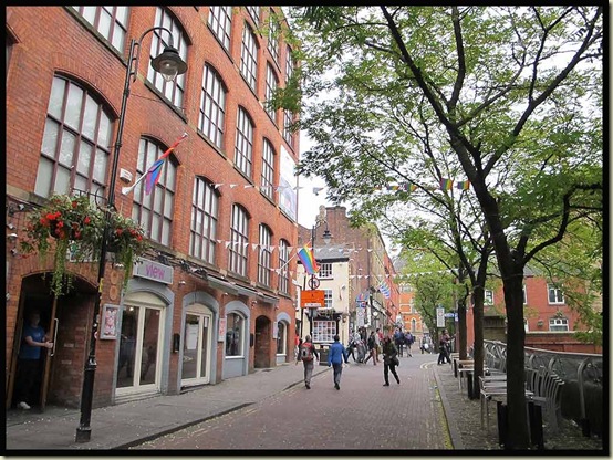
The Gay Village

City streets then led inexorably to This & That, in about two and a half hours from Timperley.  The standard fare here is ‘rice and three curries’ – currently £4.40 – and very good it is too.

This & That

Sue had eaten most of hers before I took this photo.

Curry Sue

Alan then stormed off, with the rest off us hot on his heels, to one of his favourite Holt’s establishments, the Ape & Apple, for an alcoholic afternoon whilst he waited for Sheila to finish work.  His beer stained report on the walk is here.  The rest of us joined him for a while before embarking on a variety of tasks (eg Sue and I bought a new television) and reconvening later in Hazel Grove for Mick and Gayle’s excellent slideshow relating their adventures on the Pacific Crest Trail earlier in the year.  There’s no ‘label’ on their reports, but if you start reading here, then move to here and here, and even more recent postings, you could spend an entertaining hour or two…

PS JJ’s report is here – very good it is too.

Thursday, 25 October 2012

Ramsoc Weekend at Kettlewell – 20/21 October 2012

Outside Kettlewell Youth Hostel on 21/10/12

This is the fifth Ramsoc weekend to be mentioned in these pages – it’s Sue’s University Rambling Club reunion, ably organised by Sue W, this year for the 12th and last time, and before that by Mark and Janet, who cleverly absconded to Singapore in order to avoid the organisational stress (largely caused by a single person who was absent this year).

Click here to view all the Ramsoc postings.

Saturday

By about 9.30, twelve of us were strolling through Kettlewell on a misty morning with autumn colours well on the way as we crossed the Wharfe to ascend gently above Knipe Scar, before heading down to Hawkswick and the River Skirfare.

A good path took us up beside Cote Gill, with good views back to Hawkswick and beyond.  Elevenses were taken on a grassy bank before a stream crossing, after which the cleft of Cote Gill deepened to our left.  We passed hundreds of slightly curious residents on the gentle ascent to Lee Gate.

Mother and daughter on Low Cote Moor

An old lime kiln came and went and we got a bit spread out. Great Whernside’s summit lurked in the cloud behind us.

Lunch was taken at a path junction by Goredale Beck.

Lunch by Goredale Beck

A splinter group then headed off in an abortive attempt to find a pyramid from which to view Malham Tarn, the day’s objective.

Others took the Monk's Road to get a view from there.

Malham Tarn

We soon caught up the main party again, beyond Middle House, having been delayed as much by an abortive lesson during which Mike failed to teach me how to plot a route on the Satmap GPS.  (Well, I did plot a route, but immediately ‘lost’ it!)

The party was led by three wise monks on the road to Arncliffe, leaving any thought of the need for a GPS seeming curiously stupid.

Three Wise Monks on the road to Arncliffe

Views up Littondale opened out as the skies cleared.

Llittondale

Arriving in Arncliffe at 3.30pm, there was no beer to be had as the Falcon’s landlady gleefully slammed her front door on twelve thirsty ramblers.  Earlier, other members of our party had managed to gain sustenance here, on the strict understanding that ‘no hot drinks are available’.  The feeling that soft drinks are also discouraged places this place into something of a time warp.

The Falcon, Arncliffe

Arncliffe, a village of quirky pub, chickens on the village green, and all manner of domestic pets.

Arncliffe pets

Soon we were labouring up the steep ascent of Old Cote Little Moor, and finally, with the exception of an exhausted backmarker, staggering in his Scarpa Manta winter boots under the weight of a fully laden 65 litre rucksack, the jolly band found themselves dancing back down to Kettlewell for much needed tea and cake.

Here’s our route - approx 23 km with 850 metres ascent, in 7.5 hours.

Our route - 23 km, 850m ascent, 7.5 hours

Sunday

The cloudless morning view from the YHA’s fire escape was stunning.

Morning view over Kettlewell

As usual in such circumstances, we got off to a slow start, but eventually most of the group assembled outside the hostel for a photo call (see header image).  I wonder how many of the group Mark and Janet will now recognise?

By around 10am, we were on the road to Grassington, soon stopping for views back to Kettlewell in the bright light.

We didn’t hurry, and there was certainly no need to do so, as a group of 20 of us lingered in Grassington’s car park for half an hour or so before the latecomers joined us at around 11 o’clock.

Sedber Lane, an ancient walled lane, leads down to the River Wharfe,

Sedber Lane

where a narrow suspension bridge and a series of weirs facilitate images of gleaming white water on a day like this.

Weirs on the Wharfe at Grassington

The riverside path to Hebden showed the river in a more reflective mood.

Wharfedale near Grassington

Soon it was time for a geocaching interlude – Horatio Puddleduck now has over 500 caches to his name -  and elevenses, with CCS and other delights.  Lots.

Elevenses by the River Wharfe

A Wharfedale tree

Then we left Wharfedale and passed a cafe at Hebden, where some chose to take a short cut back to Grassington.  It had already been a long day for them.

Seven stalwarts, freed from the constraints of distracted teenagers, chose to zoom up the lane by Hebden Beck to a convenient picnic table for lunch. Near here a bird of prey, probably a hen harrier, sat nearby, munching its own lunch.

Crossing the beck led to wet feet for some, but otherwise it was an easy stroll up through the debris of old lead workings to Yarnbury.

Lead workings at Yarnbury

Then Moor Lane, a quiet road even on a busy Sunday, led happily downhill all the way, past a strange skeleton, to the fleshpots of Grassington and our onward journey home.

Descending Moor Lane to Grassington

Here’s our route - 11 km, 200m ascent, 4 hours (feasibly quicker) – an easy half day stroll.

Our route - 11 km, 200m ascent, 4 hours

There are more pictures (and commentary) for anyone interested, in this slideshow.

Friday, 19 October 2012

Sunset in Timperley

Sunset in Timperley - 19/10/12 We don’t have a ‘Mountain View’ here in Timperley, but occasionally we do enjoy a nice sunset whilst scoffing our dinner…

Wednesday 17 October 2012 – Around Glazebury

Chat Moss Hotel - a meaningful pub sign!

Itchy feet on a sunny afternoon drew me to explore a few red dots on Explorer Map number 276.

It’s a short drive from Timperley to the village of Glazebury, where the Raven Inn’s car park has plenty of space for customers.

From the Raven Inn, I headed down Heyshoot Lane and after a few metres turned left along Moss Lane. A path to the left after 300m took me over a stile and into a slightly wet field, leading to Light Oaks.

Beyond the farm, a left turn leads past the lovely old building that is Light Oaks Hall, whose history apparently dates back at least as far as the 14th century, though the current building dates back only to early C17.

Light Oaks Hall

Crossing the bridge over Glaze Brook, I re-entered Cheshire, after having paid brief visits to both Greater Manchester (Salford) and Lancashire (Wigan).

Glaze Brook, at Glazebury

A right turn at the main road took me past the Chat Moss Hotel.  The hotel is adjacent to the world’s first timetabled inter-city passenger railway.  The Liverpool and Manchester railway was opened in 1830 by the Duke of Wellington, and one of the world’s first railway booking offices was on the premises of the hotel that formed part of what used to be Bury Lane Station. 

Continuing under the railway bridge I arrived at the C of E parish church - All Saints, Glazebury.

All Saints church, Glazebury

A left turn down Hurst Lane leads to a health conscious farm where visitors have to dunk themselves in chemicals before entering.

Amongst the farm buildings stands Hurst Hall, built around 1700.  It was originally the residence of the Holcroft family, a branch of the de Culcheth family, who were Protestants, and therefore Parliamentarians in the Civil War. The Holcroft family also enjoyed notoriety for a scandal involving the daughter of Lt-Col John Holcroft, an officer in Cromwell's army.  His daughter, Maria, married Irishman Lieutenant Thomas Blood in 1650 in nearby Newchurch before moving back to Ireland.  He was later to be promoted to the rank of Captain.  Captain Blood then gained notoriety for devising a plot to steal the Crown Jewels from the Tower of London and using them as a ransom for Charles II.

A thin path rich with either disinfectant or rainwater (it was hard to tell!) led me around the left perimeter of the farmyard, soon reaching a pedestrian crossing across the line that was used in the Rainhill trials in 1829.  Stephenson’s Rocket now features in the Chat Moss pub sign, as shown above.  It was easy today to dodge the Arriva trains that nowadays service the route.

Suddenly, a thunderstorm arrived to interrupt a sunny afternoon; shame I’d not got waterproofs with me!

My old Keen trail shoes had their waterproof lining tested yet again, as I took a left and immediate right after the crossing, past a lone beech tree to a path junction for a right turn through wet ground to a small footbridge, then bearing left down a flooded path after which a series of left turns brought me back to the Raven Inn, past hedgerows that were just about gaining an autumn tinge.

The leaves are turning - 17/10/12

The Raven Inn, Glazebury

Here's the route - just a brief dose of fresh air spiced with disinfectant on an October afternoon - it can be easily extended (see Explorer Map 276).

A short walk around Glazebury - 4km, under an hour

There’s a short slide show (17 images) here.

Tuesday, 16 October 2012

Sunday 14 October 2012 - The Calderdale Mountain Bike Marathon (CMBM)

Starting in Bowood Lane

This blog passed its fifth birthday unnoticed, in a flurry of Marilyn Bagging activity with M2.  I’ve now realised that fact, as this is my sixth report on the annual mountain biking event - CMBM.

The CMBM reports are all here, with route details and a results summary specifically here.  The CMBM website is here.  Next year’s event will be on Sunday 13 October 2013.

I was faced with a decision as to whether to use ‘Stumpy’, the full suspension bike I’ve had for over a year.  The bike is fine, but on rough ground bits tend to fall off it.  I could see that conditions would be very muddy, so I chose to take ‘Shogun’ on its 11th CMBM.  ‘Shogun’ has closely fitting mudguards.  Today that meant that my back stayed clean and dry, whereas most folk looked as if they were encountering severe bowel problems.  In fact, a number of few riders politely enquired as to whether I was really taking part in the event, as I was pottered along in clean clothes on the bike that is so ancient that it sometimes gets ‘wow, a classic bike’ comments!

It was a beautiful day, starting with the scraping of thick frost from the car, then fog on the motorway, with mist gradually dissipating after the 9am start, where about 350 of us assembled in Bowood Lane near Sowerby Bridge.

CMBM start 2012

Early sections of the ride weren’t any more muddy than usual, and it was disappointing to find that the rocky descent to Mytholmroyd has been ‘sanitised’, meaning there was no need for anyone to dismount on this previously tricky descent.

It’s a steep climb from New Bridge to the second support point, where I stopped for a while this year.  The picture below demonstrates the brilliant performance of those at the support points.  Whilst some riders take a break like I did, many just keep going, taking drinks and food from the supporters without needing to dismount.  There’s no need to carry a map, as all the significant turns are both signed and in most cases are manned by marshalls.  The aim of the event is to present a personal mountain biking challenge, at the same time raising funds for the local Scout group.  This year there were two other events taking place on the same day over different routes.  We were told to ignore the yellow signs!

Support Point above Hardcastle Crags

After Walshaw Hamlet there’s a steepish climb up to Shackleton Knoll.  This year the surface was so slithery that I didn’t see anyone managing the ascent without needing to dismount, though I’m sure the leaders managed fine.  Here’s Scott Oddy near the top of the hill, where the gradient eases.

Scott Oddy rising to Shackleton Knoll

Looking back down the hill, many of those in the picture are walking up the steeper sections, where the ground this year was too smooth and slippery to gain traction.

Cyclists ascending towards Shackleton Knoll

After this there’s a long bumpy descent – one of the sections where Shogun’s lack of suspension means that I’m comparatively slow compared with most riders.  Then, after a pleasant road section, comes the crux of the ride, the moorland crossing culminating in the technical descent from Midgley Moor, where most of the event photos are taken.  Click here (for a limited period) if you want to view images of bikers in all manner of weird positions and thoroughly coated in mud. Robert and I look relatively sensible compared with many others!

Whilst neither Robert nor I fell off, we found it very difficult to avoid the foot deep slurry of peaty puddles across the moor.  The waterproof lining in my well used Keen trail shoes (see footnote) proved to be up to the job, combined with close fitting ankle gaiters, and my feet stayed comfortably dry, albeit coated in slurry from a misjudged pond crossing.

It was a particularly tiring morning, and for the first time in eleven years, albeit with nobody in sight behind me, I walked up the start of the steep hill to the finish.  In fact, I followed a large group who were all also walking.  But I finished in the saddle…

Approaching the CMBM finish on 14/10/12

Then it was into the routine of enjoying some tea and soup, collecting the t-shirt and finisher’s certificate (and this year a Thank You card ‘In appreciation of your support over 10 entries of the CMBM’), throwing the bike into the back of the car, a quick change, and a celebratory beer with Robert at The Church Stile Inn, where we stood outside with our beers, cheering on the people still approaching the finish.  In this case, Alistair Murphy.

Alistair Murphy approaches the finish

As you can see, it remained a lovely day.  Who says the weather is always bad in the UK?  They are wrong.

Beer o'clock

Today’s Statistics:

Winner – 2 hrs 6 min – 332 finishers – slowest 5 hrs 35 min
Robert: 3 hrs 1 min – 88
Martin: 3 hrs 37 min – 183

Here’s the Garmin gadget version of the route:

A footwear note:

This year I used my Keen Targhee 11 Walking Shoes for the second time.  These are now nearing the end of their days after 1400 km of walks and numerous bike rides.  I used them together with close fitting ankle gaiters and Sealskinz socks which in the event weren’t needed, as the shoes and gaiters combined withstood the substantial barrage of water and slurry.  My feet stayed perfectly dry.  Robert witnessed the peeling off of the outer layers. So, more plaudits for these splendid Keen shoes. 

Keen Targhee 11 shoes after 1400km