Sue and Martin in Mallorca 2019

Sue and Martin in Mallorca 2019
On the Archduke's Path in Mallorca

Tuesday, 11 August 2020

Tuesday 11 August 2020 - A Circuit from Drinkwater Park

 
Today's walk and its route were inspired by my desire to revisit the venue of a walk that Dave, Laurie and I enjoyed on 22 October 1995, the pictures from which outing I scanned yesterday. The sparse report and few images from that occasion were a bit meagre for a separate posting, so the old diary entry and pictures are appended to this entry.
 
Today the digital age ruled ok, and I took 79 pictures. I've managed to cull these to about 30, so bear with me... You can always click on an image and view the (not particularly exciting) slideshow.
 
The Drinkwater Park car park, at the end of Kersal Vale Road, seemed a good place to start, conveniently about half an hour from home. From there I crossed Agecroft Bridge, pictured above. The ornate waterworks bridge on the right was built around 1832 to house the Thirlmere Aqueduct.
 
My route took me past the massive cemetery, then past a chemical works. That works must be shut down, judging by the colour of the effluent. Past visits have revealed orange sludge the colour of the stone (if it is stone) under the grating in the next picture.
 
 
The Manchester skyline from the banks of the Irwell looks full of high cranes these days.
 
 
I crossed the footbridge that leads to Kersal. A dead crow languished under the girders, having got trapped in some wires.
 
 
The river was briefly re-joined. The familiar looking bridge is one that we cross on our bike rides to Bury. However, on this occasion I continued along the left bank towards The Cliff.
 
 
I was unable to find the boardwalk that I photographed in 1995. It was somewhere around here - it must have rotted away.
 
 
After entering mature woodland, dappled sunlight sprinkled the ground on the hot sunny day.
 
 
The Cliff is eventually climbed, past the debris from grand Victorian houses and their gardens that were the victims of a series of landslides in the 1920s and 30s, causing the houses to be abandoned.
 
 
Even some of the old tram lines at the top of the cliff have vanished into oblivion. The rubbish that I've noted on previous visits does seem to be slightly more under control today, with evidence of skips, and lots of 'No Dumping' signs.
 
The closest buildings to the cliff these days are some fine looking villas, like this one - Cliff House.
 
 
In the Speakmans' 'Best Pub Walks in and around Manchester' book, they mention the Horseshoe Inn and the Star Inn. Today, the former looks shut, but the Star is clearly open for business. I was too early.


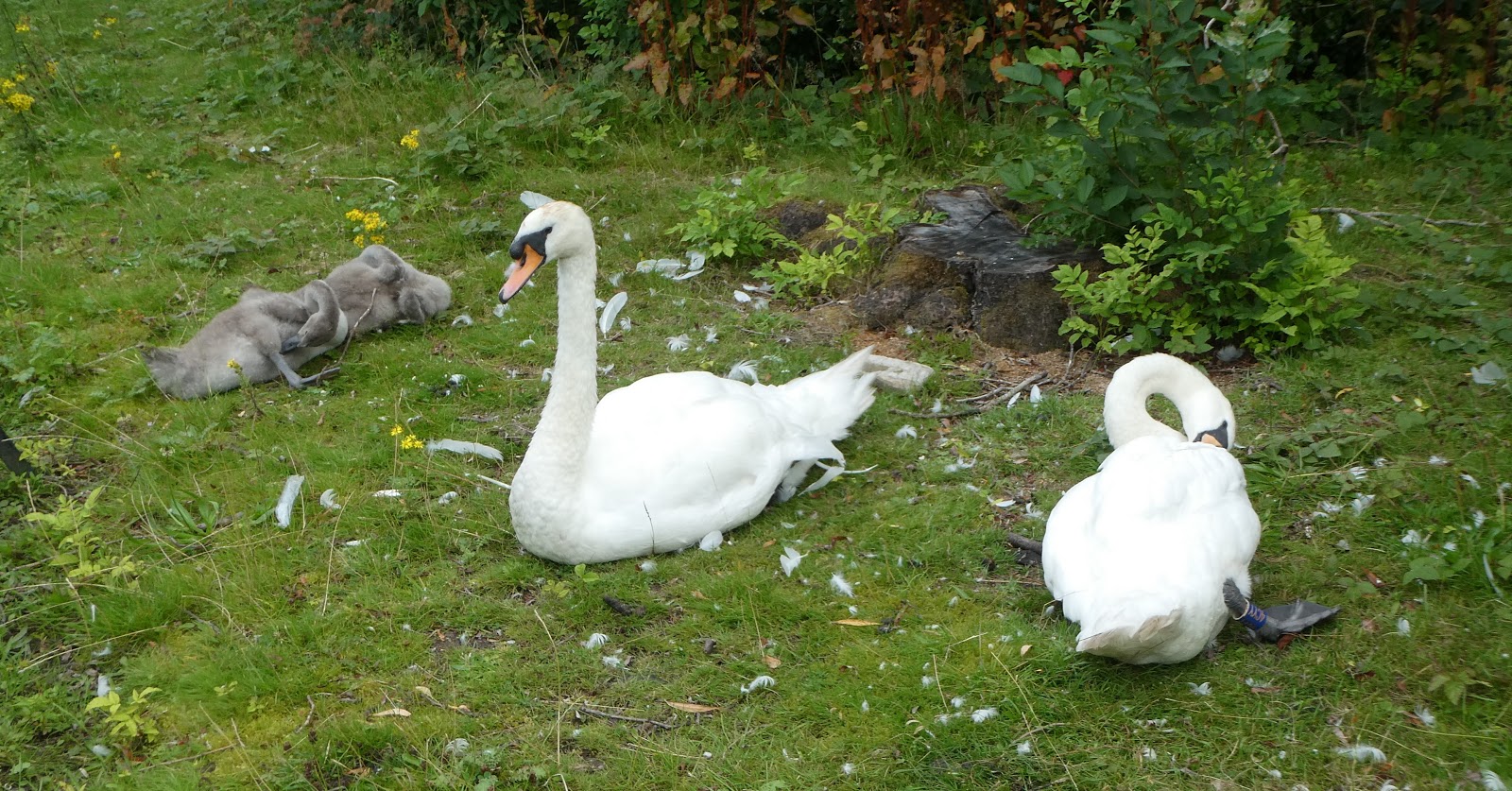
I made my way to the delightful Broughton Park, in the centre of the area's Jewish community. Here, the swans and their two cygnets were lazily preening, before setting off on a tour of the pond.
 
 
There were coots, as well as these moorhens, and look at all that rubbish in the bottom picture, indicating there is still a serious 'rubbish' problem in this area.


If you click on the next picture you should be able to spot the swans.
 
 
I thoroughly explored the park, walking in a large circle, as I was seeking out the gothic spire of the United Reform Church and 'the sadly overgrown ruins' of the church. Here it is, much changed from the state it was in when we passed by in 1995.
 
 
After that pleasant surprise, I headed off past Crumpsall Metrolink station and on to the Irk Valley and Blackley Forest, near where I had my first house.
 
There was a sign regarding the boardwalk to the north of Blackley New Road.
 
 
Ignore the sign. It's fine.
 

At Victoria Avenue there's a fine bridge over the River Irk, with a plaque that remembers the councillors rather than the architect.
 
 
The Heaton Park Tramway looks pretty intact to me. It's a shame that they seem to have degenerated to little buses instead of the trams.


Having already stopped for a cuppa in Broughton Park, I was thirsty again on the ever hottening day, so I found a suitable bench. It turned out to be a new one, in memory of a parkrunner, Jim Smith. Heaton Park is a very well attended parkrun venue, in normal times, and Jim must have been a stalwart participant.


There were lots of people in the park; many families with children, and a good number of elderly folk as well.
 
 
A short stretch of tarmac took me past Prestwich Metrolink station and down Church Lane, where the Church Inn looked welcoming. A walk around the perimeter of St Mary's church led to a cobbled path down to Prestwich Clough, which was pleasantly cool and shady. 
 
 
A rat jogged along ahead of me.
 
 
After a section of path surrounded by 7 ft high Himalayan Balsam, the main cycle route number 6 was reached leading pleasantly back to Drinkwater Park and the small car park beyond a horse mounting stand.
 
 
Here's my route - 17.5 km, including a complete lap of Broughton Park and a few other extra bits. Without those it would be about 16 km (10 miles). There's only about 150 metres of ascent, and it took me rather less than 4 hours at a leisurely pace.
 
 
So how did we fare on a similarly sunny day in October 1995?
 
Here's my report:
 
Sunday 22 October 1995

Prestwich Forest and The Cliff

Another lovely day. 8 am start not really onerous due to clocks going back, and early rise to watch Schumacher win Japanese GP and his second F1 Championship running. I'd also recovered from the dampness of yesterday's Log Plume/River Rapids at Alton Towers.

Cloudless day; frosty early; autumn has arrived.Dave and I arrived at Laurie's in time for an efficient departure. Decided on a short walk as Dave had to return by 2:30 to get washed in time for the 5:30 train to his Gran's funeral.

Our chosen walk is 'Prestwich Forest and The Cliff', from Prestwich to Crumpsall via Prestwich Clough, Carr Clough, Prestwich Forest, Drinkwater Park, the River Irwell, The Cliff, Kersall Dale, The Star Inn (shut - we were too early), Broughton Park (a Yiddish enclave) and the sad remains of the United Reform Church.

(Walk 3 - Best Pub Walks in and around Manchester.)
 
This was a very pleasant six mile amble, with just a few strollers and joggers with dogs around. The only hikers were at our start at Prestwich Station, where ramblers were waiting for a coach to take them to their start from the place to which we had driven to start our walk!

Some sewerage/chemical smells on our route. Regeneration efforts in Prestwich Forest are well under way and to be commended. Lots of poplar trees, the white backs of whose leaves glinted cheerily in the sun.

The River Irwell section was a gentle stroll, but an upside down Vauxhall Astra did blur the river view. It looked recent, and as we wondered whether a call to the police may be desirable, two officers appeared.


Caption competition?
 
We passed the derelict ruins of the Victorian mansions on The cliff that have now subsided into piles of debris. A pair of sparrowhawks languished overhead as we progressed onwards to the delightful Broughton Park. The children's playground seemed a throwback to gentler days when there was no vandalism and life was sedate and sweet. (Was it ever.) The dog proof entrance gave the game away though, but inside the children played happily in the sun in a well equipped arena.

The Cliff - Boardwalk
 
Lost as ever - 'poor Laurie!'
 
 Broughton Park, and below 'the sadly overgrown ruins' of the United Reform Church
 
 
Remember these trams?
 
Our route on 22/10/95 - 10 km, taking a good couple of hours

Monday, 10 August 2020

14 to 25 July 1989 - Alta Via 2 - Day 0 - Getting to the Start

 
The Famous Five go to Venice
(Subtitled: Dolomitic Dawdling)

Introduction: This is the illustrated transcription of a diary maintained by the five participants of this 1989 holiday. The photo album from which I have scanned the pictures includes photocopies of the relevant pages of the Cicerone guide to Alta Via 1 and Alta Via 2 (AV2). We didn't pack the whole book on grounds of weight. I have however scanned the overview maps, and I've plotted the route using Viewranger mapping. Obviously this trip took place over 30 years ago, since when there will have been numerous changes, not least a ban on camping in many of our overnight resting places. The current Cicerone Guide will no doubt be very helpful with the planning and execution of this walk in current times, subject to things returning to 'normal' after Covid.
 
The map shown above, taken from our diary, places the red line of our route into context. As always, click on the image for a more readable version.

As usual, I have kept editing to an absolute minimum. The story will be principally of interest to Dave and Martin W, who were there and who will no doubt recall some of the more 'interesting' moments. Their comments will be welcome. (I already have one from Martin.) We will also recall the good times, adventures, and companionship we enjoyed with Laurie and John, who are sadly no longer with us. So this little project is to a degree in their memory.

You might think from the following text that we were backpacking novices. In fact we had all been backpacking for many years, and in the Alps and Pyrenees since 1980, so deficiencies may be attributed to a mixture of work and family pressures, as well as inherent incompetence.

It's interesting to note that we have moved on from the days when three of us squeezed into a Vango Mk 4 tent - on this trip we all had our own single person tents.

The timing of the trip - 10 days' walking plus two days travelling, was quite ambitious and was dictated by holiday quotas. It was actually a little less demanding, height and distance wise, than a trip to the Pyrenees the previous year. However, I'll allow more time if I do this route again. And I may by-pass some of the trickier sections.
 
Here goes: remember this is my indulgence, and may be of passing interest to my children one day, but you don't have to read it!

(Diarist: Martin B)

Nell was up bright and early at 5 am on Friday 14 July 1989. John and Martin B were soon up and after tea had been taken, Ford Sierra E64 UNA commenced probably its last taxi trip, collecting Dave on the way to Terminal B for the 7:25 to Venice. Laurie and Martin W made their way by supertaxi, and the five met up without incident.

Laurie had solved the problem of keeping the taxi waiting by staying up all night. He has his weighty grip and filofax once again so is unlikely to be getting very far ahead.

Whilst waiting, the cloud rolled back and blue sky took command.

Onto the Monarch, and D, MB and J have a jolly time looking at Dave and Laurie's packing lists, and a not so jolly time on the subject of Dave's ailments of last year. 757 to Venice was ok until another plane's baggage got unloaded before ours. 1¼ hours later we were away.

Timing problems meant we failed to get our designated train from Venice, but after a taxi ride and a boat ride, despite L's preference for buses, we arrived at Venice station with 2 hours to spare before the next train. Various sorties resolved 'THE GREAT CAMPING GAS PROBLEM' and various food deficiencies. Very hot and humid. Both Martins have headaches.


Decent train journey to Bressanone despite changes at Verona and Bolzano.

Interesting valleys and views. Hilltop fortresses, tremendous road engineering feat (leading to the Brenner pass).

Snooze the journey away, as well.

2:45 -  Venice, 7:18 - Bressanone. Laurie careers about oblivious to the Consulting Quartet. He eventually loses us. The quartet decide to find a B&B. Laurie finds a map and sprints off. He is full of energy today - he has not yet attached his grip to his rucksack. John and the two Martins are fairly manageable weight wise, but I (Martin B) realise with dismay that I have packed two stoves.

Laurie returns, grinning. He has found the campsite. We have another coffee, then go to a one star hotel previously spotted as cheap. They don't seem to do rooms. Go to a 3-star hotel and find two rooms for 140,000 lire (£63). The restaurant has stopped serving (9 pm). Wander aimlessly looking for food. Lots of false starts. Fail. Martin W adjourns for butties in the room, and the rest of us make do with beer and coffee.

Animated conversations on business writing techniques and Laurie's rucksack.

In bed by 11 to 11:30 (really an hour earlier due to clocks changing) at the Hotel Chiavi d'Oro (The Golden Keys).
 

Sunday, 9 August 2020

Saturday 8 August 2020 - (not)parkrunning

 
We had the pleasure of parkrunner Annie's company at 8am for Saturday's (not)parkrun, my 48th (not) parkrun outing and Sue's 18th. We chose our usual route from home, taking about 30 minutes, then Annie ran back to her parents' house to take part (with us) in Vassos Alexander's 21st parkrun quiz. So that's 21 weeks without a 'proper' parkrun. 10/15 in the quiz - "rubbish" - that's the report on the questions, not our answers. It's great fun though, and thanks go to Vassos and family for hosting these weekly quizzes.
 
After the quiz, Sue and I cycled down to the park and met a few of the stalwarts in a socially distanced manner. It was great to see them in person, rather than over 'Zoom'.


Luckily it was lovely weather, the shade was welcome, some of us had flasks; others took advantage of the Courtyard CafĂ©'s take out service. The only people who are vaguely close to each other in the above pictures are members of the same households. 

Saturday, 8 August 2020

Friday 7 August 2020 - A Circuit from Hale

 
The 'Friday Team' assembled at Paul's house in Hale for this stroll featuring the Bollin Valley and the surrounds of Manchester Airport.
 
The Bollin Valley is a pleasant green groove on the outskirts of Manchester. The River Bollin runs from around Langley near Macclesfield, and drains into the Mersey at Bollin Point, near Lymm. There's a marked trail, the Bollin Valley Way, which runs for 40 km (25 miles) from Macclesfield to Partington, roughly following the course of the river.
 
 
High volumes of water early in the year resulted in a few landslips, including the one shown below.
 
 
There are also a number of 'beaches', where families with dogs were bathing in the river on this hot day.
 
Overhead - a comparatively rare sight:
 
 
After a break for tea and cake in view of the deserted second runway, (presumably not in current use)we came to the runway tunnel, eschewed on this occasion in favour of an alternative route beside the main road.
 
 
Then it was back to the Bollin Valley and the sweet fragrance of rampant Himalayan Balsam. This invasive species should be removed, but currently, I think, volunteers to uproot the plants are inhibited from doing so by Covid restrictions.
 
 
Some of the fields are simply grassy, others are full of thistles, and elsewhere the dreaded ragwort is rife. Somewhere there may even be a 'proper' meadow with a variety of species.


Here's the route - 19 km with 150 metres ascent. It took us four and a half hours.
 
 
Thanks for your company on this very pleasant stroll, folks. It's the Sandstone Trail next Friday - if anyone else would like to join us, let me know.