Sue and Martin in Mallorca 2019

Sue and Martin in Mallorca 2019
On the Archduke's Path in Mallorca

Saturday 31 March 2012

Saturday 31 March 2012 – A Kentish Bimble

Tree near Rolvenden

As expected, the weather has changed.  A thin mizzle coated the car as we stocked up with provisions at Tenterden.

Luckily that had cleared by the time we set off from Waters Edge on a very pleasant 20+km bimble through the pleasant Kentish countryside.  Well marked paths meant that any navigational mishaps were entirely my fault.

The spring flowers are well on here – daffodils in profusion, with plenty of Lesser Celandine, Dog Violets, Cuckoo Flower, Primroses, Wood Anemone, Bluebells and lots of hedgerow blossom, to name but a few.

Daffodils

As we proceeded along a route designated as the ‘High Weald Landscape Trail’, we noticed that many of the houses have curiously designed roofs and weatherboarding.  These buildings were oast houses, with kilns for drying hops.

A typical Kentish house

We left the trail shortly before reaching Rolvenden Station – a reopened railway that uses steam trains.  It starts business for the year tomorrow, and was a hive of activity as volunteers brushed off the winter cobwebs and got the stock ready for action on the line that runs just ten miles – from Tenterden to Bodiam.  Whilst we were stopped for lunch in a sheltered spot next to some badger setts by Mount le Hoe, four biplanes approached at speed and treated us to an aerobatic display before heading off as quickly as they arrived.

Biplanes

The Bull at Benenden didn’t look open, so we enjoyed the dregs of our tea on a bench by the cricket pitch, where sadly there was no game today.

Nearby, St Georges church has an impressive 12 bells, and lots of ‘peal boards’.  Not to mention the stunning windows.

Window at St Georges, Benenden

Today we got used to rabbits and squirrels darting in front of us.  The only people we saw were a handful of dog walkers.  But on some grass near Benenden something was busy scurrying and digging.  It turned out to be a busy Green Woodpecker.  A fine specimen, presumably well fed on worms.  But shouldn’t it have been in a tree?

More on the plentiful bird life around here in a future posting.

Here’s our route – 20km (plus a bit where I misread the map), with 325 metres ascent, taking us a little over five hours.

Our route - 20+km, 325 metres ascent, 5.5 hours

All in all, a very enjoyable start to our sojourn ‘down south’.

PS  We seem to have intermittent WiFi here, so bear with us re comments.  Yours are welcome, but we may be unable to respond.  I do have to apologise for my recent mis-spelling of ‘Strawbury’ though.  Sorry, JJ (and well spotted!).

Friday 30 March 2012

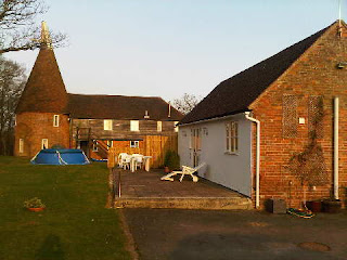
Waters Edge

This is our home for the next week - the building on the right. It's one of Forsham Oast's outbuildings, tastefully restored by the current owner.

Forsham was owned by Osbert de Forshamme in the days of King Edward 1, and Sir John de Forshamme held it, by old dateless deeds, in very early times.

The remains of an ancient chapel lie outside our front door. Beside the house is a pond with all manner of life, including Valerie and Trudi, Aylesbury ducks who will be providing us with tasty breakfasts.

Wednesday 28 March 2012 – The Lancashire Trail – Part 6 – Mellor to Whalley (Episode 2)

Norman demonstrates his plumbing skills at Whalley Weir

Time permits only a brief report on this walk just now.  Episode 1 will follow after Easter.

Towards the end of the walk, on another lovely summer’s day, Maude asked Norman, our resident ‘Plumber’, if he would be kind enough to demonstrate the skills of a ‘Master Plumber’.  When he had returned from his dunking, and Reg had dried him out, Norman looked at Maude with a puzzled expression.  “I said ‘Master Plumber’, not ‘Mad Plumber’” barked Maude “you stupid man!”

Back to Lancashire Trail Index

Thursday 29 March 2012

Sunday 25 March 2012 – The 27th Two Crosses Circuit – An LDWA Production

Off route, on the summit of Bull Hill - a HuMP
From the 8am start in Tottington, it took us about 4 hours to reach Bull Hill, on the ‘short’ 18 mile route taken by this LDWA Challenge Walk.  Our little group from Timperley plus hangers on was nevertheless taking it easier than most, buoyed by JJ’s superior lethargy and jokes.  Here we are, Martin, John B, Judith, Alistair, Moira, JJ, Viv, Jeanette, Paul and Bailey, lined up by the trig point, all in aid of Alistair’s surreptitious ‘ticking’ of a HuMP!

Earlier, we had started bleary eyed after the clocks had gone forward by an hour, and my stomach had been less than compliant all night, so I for one was pleased to find some friends who were doing the short route, giving me a good excuse to abandon my planned long route (25 mile) challenge.

After a ‘mud dunk’ near the start, we passed the Pack Horse Inn at 9am.  Alistair posed by the doorway, already looking for 'refreshments' on this hot summery day.

Nearby, we took turns posing by Affetside Roman Cross - the first of the Two Crosses on this walk, this one situated on the ancient ‘Watling Street’ Roman Road from Manchester (Mannucium)to Ribchester.

By Affetside Roman Cross

Jumbles Reservoir was very calm, unlike Check Point 1 – where no refreshments were on offer, just the bizarre sight of a refreshing haircut on offer from a maniac masquerading as a 'Master Plumber'.

The Barber of Checkpoint Number 1

Beyond here, we encountered the splendid castellated railway bridge by Turton Tower, and a series of minor ascents as we gently perambulated along the Witton Weavers Way.

JJ cracked a few jokes in an effort to jolly everyone along to Check Point 4 – where there was no sign of any Master Plumber (thank goodness) but lots of tasty morsels.  We stayed for ages, watching loads of folk who had already done the extra seven miles of the long route speed through.

Amorous Canada Geese broke the glassy surface of the nearby Turton and Entwistle Reservoir, as we hastened on towards….

"Oh no!" exclaimed Alistair "we can't walk past this" ... "can we?", as The Strawberry Duck failed to secure our custom.  There has to be a first time for everything, I suppose.

We cracked on at a steady 5kph (3mph), slowing only when it got the better of JJ’s bowels.  JJ further slowed us to Moira and Judith’s more reasonable pace by stubbornly taking the lead, pretending he was the only one who knew the way.

Then Alistair and I decided to ‘bag’ Bull Hill, and were a little surprised when our entire group followed.  “It's a 'HuMP'” announced Alistair, after consulting his on-line Hill Bagging List - “a hill with a Hundred Metre Prominence”.  Alistair is a HuMP spotter.

We headed off the hill, JJ still in the lead.  But the diversion had thrown him.  We weren’t exactly going in the wrong direction, but we had missed a checkpoint.  So the marshalls at Check Point 6 were slightly surprised when 9 of their 300 or so customers suddenly appeared from behind their wall, ie from completely the ‘wrong’ direction.  We were disappointed to find that the marshalls had got so hot lugging up their barrels of water that they’d drunk it all.  They did however offer a well stocked bar – sherry, whisky, beer, etc, though I was still feeling queasy and others eschewed this fine facility.  Shame!

A little further on we arrived at the second of the Two Crosses on this walk - Pilgrim's Cross on Holcombe Moor.  Dating from ancient times, the cross was removed at some point in the mists of time, to be replaced in 1902 by the current structure, which makes a nice seat.  Here, David and Bill were enjoying a beer or two in the sunshine.  We debated whether alcoholics should be allowed on Challenge walks.  JJ asserted that ONLY alcoholics should be allowed…

David and Bill at Pilgrims Cross

Three ponies kept us company from here, all the way to Holcombe Brook, where one of their number spent ages splashing itself in order to cool down, much to the amusement of the riders.

Our next objective was Peel Tower, a monument to Sir Robert Peel constructed in 1852, where there were lots of refreshments on sale and the scene was much as it would be on a sunny summer’s day.

Peel Tower

We enjoyed good views north to Haslingden and Rawtenstall, but any effort to look south was greeted by a blinding sun and its associated haze.

By the time John B had slithered down a unique approach to Holcombe Brook, and we’d watched the antics of the horse in the brook, the others had disappeared.  So John and I plodded on to Check Point 7 – and, would you credit it, there was that Plumbing barber again...

“Where’s JJ"?” we asked.  “Where’s JJ?” reciprocated the barber.  Would you credit it, he’d missed another Check Point, and after a while appeared with his entourage from completely the wrong direction.  And he thought he knew the route like the back of his hand!

By now the end was in sight (figuratively speaking) and the sun was still shining as we passed Greenmount United Reform Church, before heading down a pleasant disused railway line and back to Tottington Youth Centre for tea and soup and lots of other refreshments for those without upset stomachs.

Here’s our '18 mile' route - 28km, 570m ascent – our version that took 6 hours 37 minutes.

Our route - 28km, 570 metres ascent, 6hrs 37mins

Thanks go to everyone at East Lancs LDWA for organising such a splendid walk, with excellent support (away from the maniac barber) and lots of good food.  The weather was pretty perfect as well.

There’s a short slideshow of my pictures here, and Alistair’s excellent blog entry is here.  The LDWA’s ‘Two Crosses’ page is here.

Saturday 24 March 2012 – Andrew’s ‘Appy Amble – A Peak District Wander

Starting off from the layby beside Ridgegate Reservoir

Andrew’s carefully crafted amble required a 10.00am departure from Ridgegate Reservoir, by Langley.  Some of us only just about got there in time.

On this occasion the ‘Famous Five’ (Sue, Jenny, Richard, Andrew, Martin) were joined by Liz and Neil, down from the Yorkshire Dales to taste some of the hillier bits of Cheshire.

Andrew led off past some forest, where the resident sparrowhawks weren’t in evidence today.  He seemed relieved when the usual tea van at Trentabank was conspicuous by its absence – that would have put us behind schedule!

Once on the open moorland above the edge of the forest, we could see a trail of people on their way up Shutlingsloe, a busy place on this warm sunny Saturday.

We soon reached the top and took our turn at the trig point.

On the summit of Shutlingsloe - Sue, Jenny, Liz and Martin

Elevenses on the summit were followed by the gentle descent towards Wildboarclough, from which we looked back to a hovering kestrel and the hordes on Shutlingsloe's summit.  Our path would now be quiet all the way to Tegg’s Nose, most people apparently preferring shorter excursions today.

Descending above Wildboarclough

A field of grazing goats provided respite from the ubiquitous sheep as we pottered on along Andrew’s carefully plotted route, which headed relentlessly north towards Torgate Farm.  Near the farm we stopped for lunch in the shelter of a wall (there was a miniscule cool breeze) with Shining Tor as our backdrop.

Lunch near Torgate Farm, with a Shining Tor backdrop

The afternoon’s perambulations soon had us up at Macclesfield Forest, where the schedule and the size of our group precluded a rest on the well positioned bench which relates the first two lines of William Henry Davies’s poem - ‘Leisure’.

Macclesfield Forest chapel

What is this life if, full of care,
We have no time to stand and stare.

No time to stand beneath the boughs
And stare as long as sheep or cows.

No time to see, when woods we pass,
Where squirrels hide their nuts in grass.

No time to see, in broad daylight,
Streams full of stars, like skies at night.

No time to turn at Beauty's glance,
And watch her feet, how they can dance.

No time to wait till her mouth can
Enrich that smile her eyes began.

A poor life this if, full of care,
We have no time to stand and stare.

Moving on from Macclesfield Forest - the place, we headed on up Charity Lane.  Some distressed mountain bikers saw us take to their preferred route, leaving the skittery pebbles for them to negotiate with care.  No animosity though, there’s room for everyone here.

Then we entered Macclesfield Forest - the forest, where on this particular path the trees always seem to look wonderful.  It’s a great forest path.

Macclesfield Forest

Through the forest and on below Five Ashes we strolled, behind schedule.  A short debate as to whether a short cut should be deployed was resolved by an overwhelming desire to visit the industrial archaeology of Tegg’s Nose quarries.  I’ve written about Tegg’s Nose before, notably here, so I’ll restrict today’s indulgence to just one of Sue’s photos.

Old quarry machinery at Tegg's Nose

Tegg’s Nose was even busier than Shutlingsloe.  Perhaps not surprising, given the cafe and toilet facilities.  There were lots of ‘Duke of Edinburgh’ students, clearly embarking on a summer of training to enjoy the Great Outdoors.  The weather won’t always be as kind to them as it was today…

We looked down from Tegg's Nose to the Reservoirs of Langley and to Croker Hill beyond – a hazy vista through which not even nearby Jodrell Bank could be discerned.

Passing through an area of brightly flowering Gorse, we noticed that it was full of ladybirds.

Bottoms Reservoir was flat calm apart from the ripples created by a pair of amorous Great Crested Grebes.  We had heard Chiffchaffs today – their arrival in the UK is a sign of spring, and blog postings from all around the country are recording their arrival.  I wonder where our Swifts are just now?

Bottoms Reservoir, Langley

Steam engines outside the Leather's Smithy distracted us briefly from a distance, or rather the raucous behaviour in the vicinity of the engines, as we completed this lovely stroll via the southern shore of Ridgegate Reservoir, before adjourning (not too far behind schedule) to tea and cake and an evening of fine dining at chez Andrew and Rosemary.  Thank you both for a splendid route and an entertaining evening.

Here’s our route - 20km, 650 metres ascent, taking a leisurely 6 hours.

Andrew's Amble - 20km, 650 metres ascent, 6 hours

There’s a slideshow here, and for those who prefer to walk a little further, there’s a report (courtesy of JJ) on a very similar but slightly longer route here.

Tuesday 27 March 2012

21 to 23 March 2012 – A Three Corbett Trip

Martin summits Creag Uchdag on 22 March 2012

Sadly I just missed Gibson when he was in the vicinity.  He can’t have been far away, judging by the similarity of our backgrounds!

I’ve now loaded a slideshow for all three days here.

The three postings are indexed below:

Day 1: Auchnafree Hill (disguised within a visit to Choinneachain Hill)

Day 2: Creag Uchdag

Day 3: Meall na Fearna

A lovely area, and easily accessed, with the walks short enough to allow one to be sociable with non-walking hosts.

Sunday Afternoon with The Pixies at Lymm Dam

The sandy bank at Lymm Dam, overseen by St Mary's Church

Slightly out of order, this short posting is really for Hazel and the Pixies, who joined us for a ‘Hide and Seek’ walk and explore in the vicinity of Lymm Dam on 18 March, at the start of this remarkable spell of early spring weather.

There’s a short (13 pics) slideshow here.

Next time:  shall we introduce some Geocaches to the ‘Hide and Seek’ fun?