Sue and Martin in Mallorca 2019

Sue and Martin in Mallorca 2019
On the Archduke's Path in Mallorca

Wednesday, 7 April 2021

Lechtal Alps Backpack - Day 12 - Ulmer Hutte to Langen (Klosterle)


Wednesday 23 July 1980 - diarist: Ruaridh - Ulmer Hutte to near Langen 

Some Dutch people we had met the previous evening had told us that the weather forecast was for at least three more brilliant sunny days, and certainly this morning dawned bright and sunny. The 40 centimetres of snow which had fallen in the last spell of bad weather would soon be gone. 

The warden came to chat to us as we ate breakfast. He was surprised that no one else was up yet on such a beautiful day, and told us the temperature had fallen to minus 2°C last night. He asked whether we still intended to try to go to the Stuttgarter Hutte, but we told him that over the next few days we proposed to take the cable car up the Valluga from the Galtzig station (2093 m), go down through St Christoph, to the Kaltenberg Hutte (above Stuben) and up to the Spullersee. He seemed much relieved at this and wished us 'Viel Spass'. 

We trotted down to Galtzig following the wide tracks of a snow vehicle (Martin took a shortcut) and after going all round the building and upstairs and downstairs, we found the departure point. It was not long before the next car left, but when we reached the front of the queue there was not room for the five of us. The twenty minutes until the next car started loading passed quickly. We noticed that here in Austria, as in France, orderly queueing seems to be unheard of. The next shock was the price -  115 Schillings each (about £4), and paying seemed to cause some problems as everyone else had come all the way from the valley at St Anton and simply needed their tickets clipped. (However much must it cost all the way from St Anton?!)

The view west from Valluga summit (2809 metres)

Another view from Valluga summit

The view from the Valluga summit was well worth waiting for. We could clearly see the distant peaks such as Zuckerhuttl (72 km away) and the Wildspitze - a white twin peaked ripple on the skyline. The spires of the Hohe Riffler across the Inn valley, with their two glaciers, beckoned - and our own tracks made over the Mattunjoch yesterday stood out by themselves in the otherwise pure white virgin snow. 

One thing which marred the view was an enormous transmission mast between the observation platform and the view of the rest of the Lechtaler Alps. However, a little acrobatics in front of the astonished faces of tourists secured a vantage point free of obstacles.

The cable route...

A lake on the path beyond St Christoph 
(today's photos are the unadjusted Kodachrome originals, complete with incredible skyscapes)

We had our first lunch just below the Galtzig restaurant, and slid and splashed our way through peat and mud down the path to St Christoph. Not surprisingly it was all hotels and restaurants, many speaking English. A mountain guide about to set off with a group of tourists asked where we had come from and where we were going, and immediately on hearing my accent he directed us in English to the start of our path. It was the first time I had been asked if I was other than Dutch! 

We bought up most of the cafe's stock of chocolate, and nearly joined a coach tour when we heard a voice inviting "All aboard what's going aboard". 

A steep but short climb in the hot sun caused sleeves to be rolled up, socks rolled down, and in my case shorts to be put on. (Nick had already had his on all day as usual.) Our second lunch stop was on a railway line (?!).

View towards the Flexen road to Zurs

Nick was in fine form and strode out ahead to the Kaltenberg Hutte. We passed a number of notable items of engineering, an unusual concrete construction which turned out to be a road tunnel ventilation shaft (quite artistic considering how uninteresting it could have been made); the Flexenstrasse - a series of tunnels and avalanche shelters across the valley from us; and a hairpin road clinging onto a steep grassy slope leading up to a small number of houses below the Gruben Spitze.

Kaltenberg Hutte (2089 metres)

After a stop for tea at the Kaltenberg Hutte, we set about looking for a campsite in the valley leading down to Langen. This proved distinctively difficult to achieve as we were thwarted by uneven, rocky, or marshy ground, or the threat of being kept awake all night by the dinging of cowbells. We gave up all hope of finding a site as the sun sank behind the mountains, and headed for the official site in Klosterle. 

However, about halfway down to Langen the ideal site suddenly presented itself - a flat grassy and not too stony area near water. There was no question of discussing the merits of the site. We just threw down our packs and set about putting up tents and cooking a meal, before lying down to sleep amongst the pine trees to the sound of a babbling brook.

Camping near Langen (1228 metres)

Today's route - 15 km with 450 metres ascent

Tuesday, 6 April 2021

Lechtal Alps Backpack - Day 11 - Leutkircher Hutte to Ulmer Hutte


Tuesday 22 July 1980 - diarist: Nick. Leutkircher Hut to Ulmer Hutte 

I awoke on my matratz at about 6:45 and got up to wet trousers. The others eventually also arose. We went outside to an absolutely cloudless dark blue sky, and yesterday's snow had frozen to a crisp surface. We went back in to our breakfast - muesli, chocolate biscuits and Primula. I ventured to ask (in German) for two litres of hot water for our brew.


When Colin paid, quite cheap due to lack of beer, the warden asked where were we intending to go? "Ulmer Hutte" Colin replied, "on the route 601". She had assumed we were going via St Jacob in the valley. As we insisted, she said we should take the lower option going towards Kapall-Kopf, the top of the ski lift. However it would still need much care due to the amount of new snow around.

Hoh Riffler from the Leutkircher Hutte

As we set off, it soon became clear that this new snow would make the going very difficult not least because what red splodges had previously been visible were now covered by this new snow. The snow had drifted, and it wasn't long before Martin (the Mad Midget) almost disappeared from view. There was some debate as to the route - Martin was now in competition with Ruaridh as he was equipped with his newly purchased Kompass map. 

After much bumbling about, a few splodges were found which led us to a wrought iron crucifix covered in icicles which had been sculpted into beautiful shapes by the wind.

Starting the hard slog to Ulmer

Ruaridh, fully protected

A lot more bumbling; Martin proved not to be immune to the hyper-suicidal tendencies which seem to grab anyone equipped with an Alpine map. A lot of slithering about on snow-covered grass, rocks and trees (!) proved fruitless until eagle-eyed MacDonald spotted a path marker. The Mad Midget was reinforcing his nickname by doing a spiderman act across gully and cornices while the rest regained the path and headed along it, splodge spotting, until we reached another path by Kapall-Kopf.

Lunchtime near Kapall-K, looking east

Here we had our first lunch, the day's chocolate issue having already been eaten or melted by the hot sun. Speck (smoked bacon), caraway bread and dates were eagerly consumed (and chewed and chewed and chewed). From here, Martin estimated two hours up to the Mattunjoch. In fact, it eventually proved to take about 2 hours 20 minutes.

The lunchtime view SW, towards Kaltenberg

Throughout this long slog through snow which was invariably deep, but varied between over boot and up to waist, the sun beat down relentlessly. My Lawrence of Arabia outfit came into evidence again, and was soon copied by Martin except that he hung his tea towel over his face! Ruaridh had a blue J-cloth yashmak over the lower part of his visage, and Colin used a revolting grey/white handkerchief. Dave was content with his silly yellow sun hat. 

Martin had trouble seeing through his Batman / Sherpa Banfield sunglasses as they had become scratched through resting in his tit pocket. Consequently, as we now examine the damage, he has one side of his neck more burnt than the other due to putting his head on one side. I note for myself that I have a lighter coloured mark on my right wrist where my ice axe strap was, and that I'm also burnt through the gap at my shirt cuff!

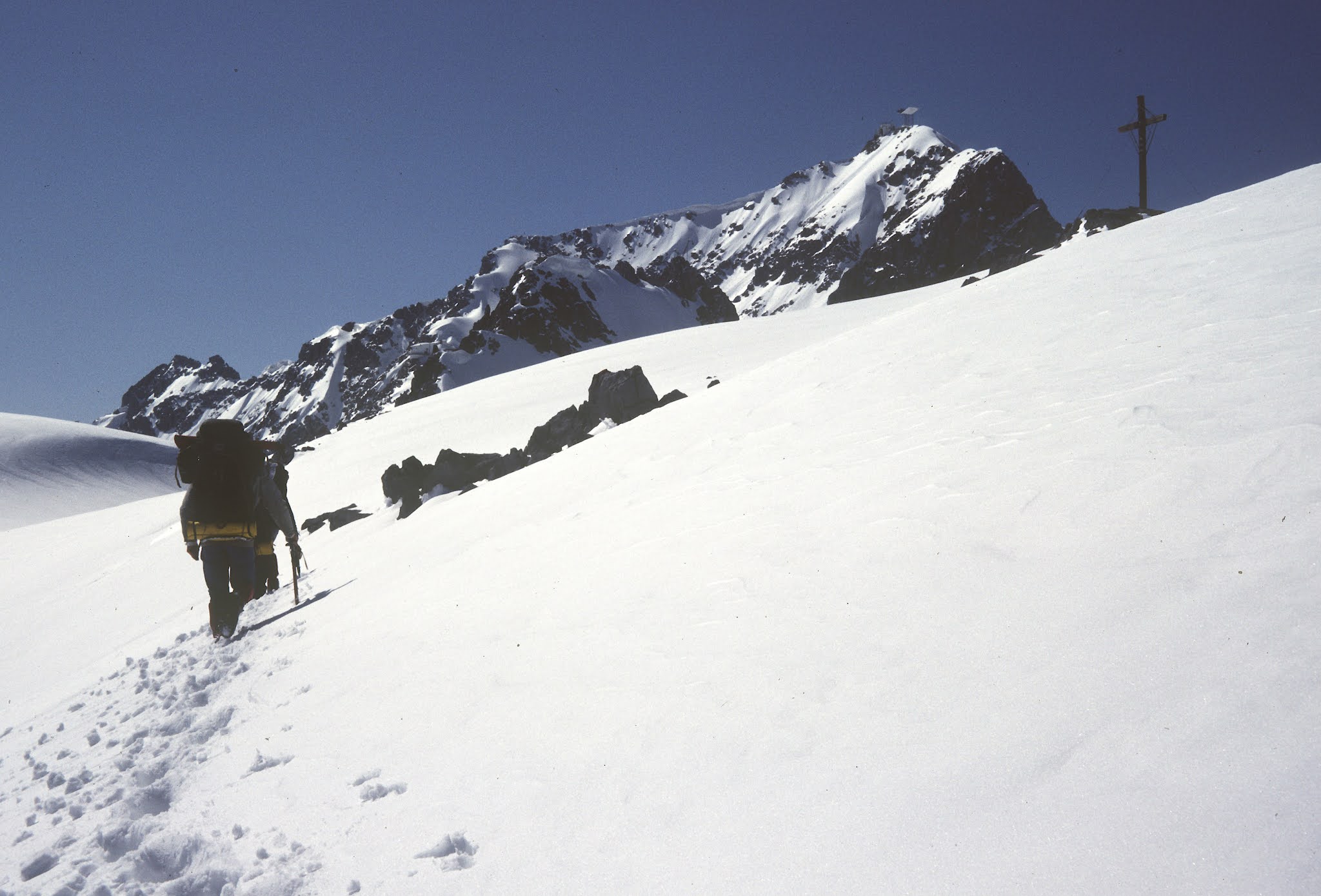
Onwards towards Valfagehrjoch (2543 m), with the Valluga summit in view

There was a cross at the Valfagehrjoch, and we could see cable cars heading up towards Valluga. There was a horrible motor noise coming from behind Schindler Spitze. We never found out what it was but assumed it to be coming from something to do with the cable car. We had our second lunch here - more speck and brot. The speck was definitely a good buy, even though I say it myself, (bought in my capacity as catering supremo).

View from the 2543 metre col, with a Valluga cablecar

We reached the Tirol - Vorarlberg border and saw down to the Ulmer Hutte and an Austrian Post Office Relay Station. The descent looked fairly easy and Dave fancied a run as usual. However, though a lone skier and a tracked vehicle had preceded us, the going could be described as 'very soft', thus all fast methods of booted descent were out. Another long slog. 

Ruaridh got us in to the Ulmer Hutte, very posh. Obviously mainly geared towards skiing in winter. Duvet blankets so no sleeping bags required. 

Evening meal consisted of goulash soup and brot, and sausage and salad or schnitzel and rice, followed by apfelstrudel and cream. An excellent meal washed down by apfelsaft. Colin fancied the waitress and kept giving her sweet smiles but he didn't get anywhere.

Ulmer Hutte (2279 metres)

Today's route - 8 hard km, with 500 metres ascent in deep snow

Discussions with the warden revealed that the R601 path was officially closed and that we should not have come down on today's route. He was not prepared to show us the next section - most sensible we thought in view of the conditions. He said there was avalanche danger and that we should keep below 2000 metres. 

We decided on a fairly low level route for the rest the British Loonies Expedition. 

Several beers, and then a few more. Ruaridh was in fairly dire straits due to lack of schiewasser, whilst any lack of coherence here is a side effect of the beer. Heat exhaustion and sunburn rules ok. Off to bed. PS Martin has now learnt to pour beer. Over to you McP....

Monday, 5 April 2021

More Adventures in Lockdown


Given there's not much of interest to write about at present, I've been casting back to old diary entries and photos in the main, whilst recording the onset of spring in my weekly reports on walks with Graeme.

This entry, mainly for Dot's benefit, fills in a few gaps regarding our lockdown activities and growing grandchildren.

On 14 March, Sue and I enjoyed a short walk around Lymm, passing St Peter's church in Outrington (above), before heading down to Spud Wood for a walk through mud beside the Bridgewater Canal on the opposite side to the towpath.

I didn't realise the recent floods had been serious enough to beach this vessel, seen before we strolled around Lymm Dam in view of the resident cormorants!


Meanwhile, Isabella was behaving perfectly.


Except when forced to eat mushy gruel...


Jacob and Jessica and Kate were busy taking happy selfies.


And I was keeping up a daily (not)parkrun, this one being number 272, during which I was overtaken by a young girl on a penny farthing bike.


Tea in the garden after (not)parkrun number 272

Jessica busied herself composing an excellent collage, which I was required to print out for her.


The blossom in De Quincey Park triggered a pause during another (not)parkrun.


Isabella soon learnt that gruel is preferable to starvation! Sweet potato went down well.


She slept soundly while Sue and I took her on three laps (10 km) around Fletcher Moss on 27 March.


Back in Timperley, it was 'out with the old'


and 'in with the new'.


On the same day, 29 March, a walk around West Sale was enlivened by clumps of Lesser Celandine, Daffodils, a hedgerow of Blackthorn, the distinctive call of Chiffchaffs, and a cooing Wood Pigeon.


At the same time, Phil was laying the last of our new carpets, delayed for months by Covid. What a relief, we were getting a bit fed up with the sight of the gripper rods that we exposed at the end of November to make life easier for the decorator.


On Saturday (April 3) we celebrated the new Lockdown 'rule of six' with a small gathering of parkrunners around a couple of separate picnic benches at Wythenshawe Park, encountering a few folk (some just in passing, and all well socially distanced) we'd not seen since they supported me on the 'virtual marathon' I ran in the park last October.


Then Sue and I took grandma Dot for a 3.5 km walk around Eccleshall. Cold but sunny.


Yesterday, 4 April, I managed a 30 mile bike ride in sunny weather to Moore and back.

The Trans Pennine Trail (TPT) near Altrincham

Grappenhall

Above the 'forbidden to bikes' towpath near Moore

A long stretch of newly upgraded TPT, next to the Ship Canal in Stockton Heath;
this used to be a narrow, often muddy, section

Gleaming new foliage on the quiet stretch of disused railway near Thelwall

Later, Sue and I took advantage of the most recent Lockdown relaxation and enjoyed, under the 'rule of six', meeting up with Richard and Jenny, and Sue and Phil, in a garden. Hopefully in May we will be allowed to meet people indoors, but this was a very welcome 'garden' reunion.


Finally, today we had the pleasure of a garden/park visit from Kate and J & J. The swings in Walton Park came first, as Oscar the dog needed a walk, even if Jacob didn't think so.


Then the slide and other playthings at the more or less deserted Newton Park, where the blossom is in fine fettle just now, provided more entertainment.


And that just about brings us up to date.