Sue and Martin in Mallorca 2019

Sue and Martin in Mallorca 2019
On the Archduke's Path in Mallorca
Showing posts sorted by relevance for query Alderley Edge. Sort by date Show all posts

Friday, 22 July 2011

Tuesday 19 July 2011 – A Cheshire Ramble

With Viv and Steve by Dean Farm

Steve and JJ sometimes lead walks for the East Lancs Group of the Long Distance Walkers Association (LDWA).  They have an idea that the group will enjoy a 15 mile trample across the fields of Cheshire.

These walks are taken seriously.  Much planning is necessary, with many reconnaissance trips to suss out the best route.  Today was one such ‘recce’.

Starting as instructed from King’s Road in Wilmslow, I found myself totally alone, and having no idea of the planned route I decided to start by lapping the car.  I should have known – JJ was driving.  He eventually turned up, deposited Steve and Viv, and rushed off to take delivery of a staircase.

Our route comprised a circuit of Alderley Edge, starting in Wilmslow and heading across Lindow Moss, often visited on these pages, but not from quite this direction.  It’s always good to explore new paths…

JJ was waiting for us, in disguise; the staircase hoax wouldn’t fool us, surely?

A curious friend

I could swear I saw a couple of wallaby and a family of emu in the background – an elaborate hoax, even for JJ.

It had been raining.  The undergrowth, mainly nettles, balsam and willowherb, had been growing apace.  It was sodden.  So were we.  Steve came off best as he had shorts.  But he did get nettle rash.

By and by we came upon the new Alderley Edge by-pass.  The old rights of way have now been re-opened and we found our way across easily.  A local farmer, upset by the whole enterprise and the wide swathe of the new road through prime farmland, had confirmed this to Steve.

Here you can see the new road, with Alderley Edge beyond.

Alderley Edge, from near its new by-pass

After passing through a tomato factory, we reached the hamlet of Nether Alderley, where there’s an attractive church, St Mary’s, dating from the 14th century.  The yew tree is apparently 1200 years old!  There’s lots more information on this interesting place in this Wikipedia link, extracts from which are reiterated below.

St Mary's Church, Nether Alderley

The large building in the graveyard – the Stanley Mausoleum – was built in 1909 by Edward Lyulph, 4th Lord Stanley. He died in 1925 and it contains his ashes and those of his wife, Mary Katherine, who died in 1929. The mausoleum is built in ashlar buff and red sandstone with a Kerridge stone-slate roof. It was designed in the neo-Jacobean style by Paul Phipps, and is rectangular in shape, with two storeys and a three-bay north front. The central bay contains a door, above which is the Stanley crest, a three-light window and a date plaque in the gable. On the sides of the upper storey are three four-light windows. Inside the mausoleum is a white marble sarcophagus.

The Stanley Mausoleum, Nether Alderley

There’s also a sandstone schoolhouse in the churchyard, built in 1628; the school room was on the ground floor and the schoolmaster's accommodation was above. A large room was added to the rear in 1817, and in 1908 the building was restored and presented to the parish by Lord Stanley.  It is now used as a parish hall and is listed Grade II.

Across the road from the church and from Millbrook Cottage Guesthouse, is Nether Alderley Mill, a National Trust property dating from the 15th century. The watermill is one of only four virtually complete corn mills in Cheshire, and is a grade II* listed building. The mill was in active use until 1939, and was acquired by the National Trust in 1950. A period of extensive renovation followed, although the present machinery is about 100 years old. The mill is powered by a pair of overshot Victorian water wheels arranged in tandem and fed by the mill pond behind the building. The Trust regularly demonstrates grinding flour.

The flagstones of the timber-framed roof, which extend almost to ground level, weigh about 200 tons.

Nether Alderley Mill

Beyond Nether Alderley, Bradford Lane leads inexorably towards the Edge, climbing imperceptibly to its 190 metre summit.

The route goes through pleasant woodland, though it was very dark here today, under the steely grey clouds.

Woodland near Alderley Edge

Alderley Edge has appeared on these pages on several occasions.  Readers may be pleased to learn that I forgot to take any pictures today.

Himalayan Balsam (Impatiens glandulifera) accompanied us for most of today’s walk, soaking us from time to time as we hacked through its water-laden foliage.  If you look carefully you can see a bee, and apparently some bee keepers are great fans of the plant, from which an excellent flavour of honey is said to result.

Himalayan Balsam (Impatiens glandulifera)

Eventually we made it to the Bollin Valley Way.  We noticed that the path to our right was still impassable due to a landslip, requiring an alternative route to Prestbury.  There are no such problems in the Wilmslow direction, new stiles and fingerposts having been recently installed.  There are even intricate carvings on this fingerpost, below the circular plaques.

A new stile on the Bollin Valley Way

On the outskirts of Wilmslow, JJ eventually appeared, claiming to have taken successful if rather belated delivery of his new staircase.  He was looking friskier than usual!

JJ finally joins us 
We had seen no other ramblers, but on gaining the byways of Wilmslow we were joined at times by the dog walking fraternity.

The balsam is rampant in the Bollin Valley, and the citizens of Wilmslow are trying to do something about it…

Balsam Control

Here’s our route – 25km, with 250 metres ascent, in a little less than 6 hours.  An excellent local stroll for us, but of how much interest to the sturdy chaps from East Lancs LDWA?  We shall see…

Today's route - 25km, 250 metres ascent, in under 6 hours

A slide show of all 29 pictures taken today is here.

I recorded the route on the Garmin Gadget, the result of which is shown below.  It gives the exact route – perhaps useful to Steve and JJ should they want to transfer it to a GPS or tweak the route, which could easily be extended to encompass an interesting circuit around Styal.

Monday, 26 June 2017

Friday 23 June 2017 – An Evening Walk Around Alderley Edge

2301Alderley1

For the second of Andrew’s ‘Deepest Cheshire’ walks this summer, he ventured into the familiar territory of Alderley Edge, with an unfamiliar ascent of 150 metres not normally encountered in Deepest Cheshire.

Anyway, it was the Famous Five who assembled before 7.30 pm at the De Trafford Arms in Alderley Edge, where it was warm enough to enjoy an al fresco beer before setting off.

Then a short uphill slog through pleasant woodland brought us to the wide view across the Cheshire countryside to Greater Manchester, with the city’s skyscrapers, complete with combustible cladding, clearly visible, the masts of Winter Hill looming behind them.

2304Alderley4

There’s an Armada Beacon near here, built on top of a Bronze Age ‘bowl barrow’ or burial mound.

2305armadasign

After passing the site of the Hagg Cottages, mineworkers’ houses demolished in the 1950s, we left the escarpment and descended past well securitised properties owned by millionaires to the fields of the Cheshire flatlands. The light levels were low.

2307fields

This used to be a mining area, like Wednesday evening’s venue, but now it’s a sanctuary for the rich.

After a while we passed the 14th century St Mary’s church in Nether Alderley. I’ve described this before. The awful Hamilton family lived next door.

2308church

In fact I’ve described walks and places in this area a few times, so there’s no real need to add much here. If you are interested, click on the Alderley Edge label. The field paths led us pleasantly back to Alderley Edge village.

Here’s today’s route – an amiable 8 km in a couple of hours, followed by a welcome beer in the De Trafford Arms.

2320route

Next outing:
Thursday 6 July - 7.30pm from the Wood House Garden (SJ 808 702). Postcode for Satnav SK11 9DX. Parking at rear of house. Refreshments before an amble around paths and lanes in lush dairy farming country. All welcome.

Friday, 8 April 2011

Friday 8 April 2011 – Summer arrives in Alderley Edge

Sunlit tree on Alderley Edge
A walk had been planned for Mike and Anne, but their new kitchen intervened and forbade their attendance, so a closer venue was chosen, and a few folk were circulated with details at very short notice.

So it was something of a surprise that nine people and a dog turned up at the Wizard car park at 9.30 am for a morning stroll in the Cheshire countryside.

It really was the best weather imaginable – pleasantly warm with very little breeze – and the company was also excellent, with Steph and Ruby joining us for the first time and Graeme making his first appearance for many years, having relinquished the need to visit his workplace every day!

Thanks for coming, everyone, it was a morning to remember.

I’m not going to recount every detail of this walk, but I have uploaded a few photos here – not very good I’m afraid, I was distracted by the need to ‘micro navigate’ which I appreciate I wasn’t to hot on either!

Here we are on ‘The Edge’ shortly after setting off.

Early morning on Alderley Edge

It was a pleasure to walk through the Cheshire countryside today, though I was glad of the waterproof liner sported by my new trail shoes.  Others found the dew to be somewhat penetrating…

Tramping through the Cheshire countryside

Wood Anemones and Marsh Marigolds were in full bloom in the woodland glades, together with Lesser Celandine (pictured below), whilst the Butterbur that lined the banks of the River Bollin looked distinctly ‘past it’.

Lesser Celandine

At Goose Green Farm a swallow was busy hunting for flies – a resident told us that the first swallows arrived here about a week ago.  Buzzards floated high above us in the distance, below a crescent moon that was hardly visible in the bright blue sky.

We found this lovely spot for elevenses after a minor mis-navigational incident.  CCS was supplied all round, and nobody seemed to be complaining.

Elevenses

All too soon, we found ourselves back at The Wizard at 1.40 pm, where some went straight home and the rest of us had a minor battle to get some bowls of soup that they seemed reluctant to serve that late in the day.  Ridiculous but true.  The beer was nice.

Here’s the route – the blue line should enable a reader to follow this walk on Explorer map No 268 (OS 1:25000), which is recommended as the 1:50000 scale map is a little short on detail.  Note that the direct path between points 5 and 6, along the west bank of the River Bollin, is currently closed due to the river bank having collapsed near Mill Farm.  Don’t be put off by the fact that you pass a sewage works – it’s next to a very pleasant wooded section of the Bollin valley.

The walk is about 14 km (9 miles) with around 230 metres of ascent.  We took just over 4 hours at a very leisurely pace.

A circuit from Alderley Edge - 14 km, 230 metres ascent, 3-4 hours

Monday, 22 June 2020

Monday 22 June 2020 - A Walk Around Wilmslow (3)

 
For the third Monday morning running, I parked up outside Graeme's house for another socially distanced, but very sociable, stroll around the environs of Wilmslow, or, more correctly on this occasion, Alderley Edge.
 
Our path led across the golf course at a different Davenport Green to the one that Sue and I walked through last week near Altrincham, to cross the railway at Nether Alderley, to the south of Alderley Edge station. A fox strolled across the lines before this Freightliner cavalcade rumbled under the bridge.
 
 
This is an area of varied, but mainly "Upper Class", housing. We passed this delightful 'cottage'.
 
 
With a thatched roof in the background this intense patch of Monkey Flower was more striking than the snapshot indicates.
 
 
Heading north from near Nether Alderley, and with footballers' mansions (ugly monstrosities so they must be footballers'?) to our left, we paused in a field for refreshments, watching a powerful machine plant fence posts in the distance as another walker strolled past.
 
 
Back in Alderley Edge, we passed the Drum and Monkey pub (it seems ages since it changed its name from the Moss Rose) and continued through what might pass for Alderley Edge's version of social housing, eventually returning to Graeme's via the nicely manicured golf course.
 
 
Here's our 11 km route - 2.5 hours plus breaks.
 
 
Thanks again to Graeme for acting as guide, and see you next week...

Friday, 18 December 2020

Friday 18 December 2020 - Alderley Edge revisited

In fairly dreary weather, six of us (me, Sue, Graeme, Paul, Jeanette and Jenny) and Rufus the dog assembled at the National Trust car park by the Wizard cafe to enjoy a modest stroll in the environs of Alderley Edge.

I've written about this area many times before - there are already 18 postings with the 'Alderley Edge' label, so I don't propose to labour further in this entry.

The dull day made for difficulty in getting any decent pictures, but here are what I did manage to take. Click on any of them for a better image/slideshow.

Above, our socially distanced group on the corner of Bradford Lane and Hocker Lane.

Below, Rufus led the way along Hocker Lane.


A brook by Hocker Lane

We ventured briefly into Alderley Park, where Jeanette used to go running at lunch times when she worked for AstraZeneca. There are various ornamental ponds, etc, as well as Radnor Mere and some well used paths and a host of picnic tables, some of which are under cover. We enjoyed coffee and cake here, whilst it tried to rain.


We got back to Hocker Lane and headed towards Clinton Hill, where the next two pictures were taken.


On reaching the B5087, a busy road, we were presented with a home made sign discouraging use of the public footpath past Adders Moss Farm. Not wishing to upset the residents, albeit the use of the path would be harmless and legal, we took an alternative route along the road and then past Mount Farm, where no objection was made, though we had to negotiate slurry and a muck spreader.

We made it without mishap, apart from a short 'Martin's meander', to the environs of Alderley Edge, with Rufus doing the navigating after I'd been sacked for going the wrong way.


Back at the friendly cafe, we enjoyed takeaway coffees (thanks, Paul), and a line up of the reconstituted 'Three Musketeers' was captured on film.


Luckily, the picnic tables have been fitted with substantial covers to keep clients dry. This is the way of the current world - takeaway fare consumed outdoors under cover.

Here's today's route - rather less than 10 km, taking us two and a half hours.

Monday, 4 April 2016

Friday 1 April 2016 – A Stroll Around Alderley Edge

0102view1

For the first of a short series of morning walks, Paul and Andrew turned up to join me at the Wizard car park on a dull, cool, dry day.

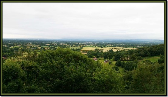
Our route was vaguely familiar, resembling some of those taken on previous visits, though there are many options hereabouts. We set off on a newly constructed National Trust path to the north, passing the viewpoint shown above and soon reaching another viewpoint at a barren area where the old mine entrance is fenced off.

0101AEpath

On a good day there are wide ranging views over Cheshire and towards Manchester. There’s an Armada Beacon near here, built on top of a Bronze Age ‘bowl barrow’ or burial mound.

During the time of the Spanish Armada and undoubtedly hundreds of years before this time, the Edge had very few trees and was predominantly heathland, making it a perfect vantage point.

It is said that in 1588 it took 12 hours for the news that the Spanish Armada had been sighted to travel from the south coast of England all the way to York.

0103view2

The area is riddled with mines and quarries. On our way down to Findlow Farm we passed a long abandoned quarry, the path drawing us around its eastern edge rather than my planned route around the other side. One of a number of ‘meanders’ away from today’s planned route.

0106quarry

The path to Whitehall Brook was a trifle muddy, but feet remained dry today despite the use of trail shoes.

0107mud

Beyond the posh exterior of Faulkner’s (not a) Farm, we reached Mottram Bridge and the Bollin Valley Way (BVW). The last couple of times I was here, the path was blocked by a landslip, but now a diversionary path has been built, so next time I’ll try the BVW route towards Prestbury. You can just see the new path in the distance to the right of the river.

0109bollin

Soon afterwards, at Top o’ th’ Hill, some red ‘Pedestrians’ signs directed us into a building site to a dead end by a fence where our 1:25,000 map showed a public footpath. After a debate with the site manager we concluded that the footpath must have been officially diverted to make room for the privacy of one Tom O’Connor, of O’Connor Utilities Ltd, in what in a couple of years time will be his fancy new mansion, no doubt mimicking the ‘footprint’ of the old farm and its outbuildings. We appear to have arrived from a direction where the signage and explanation for the closed path were inadequate.

0110connor1

After eventually finding our way around the obstruction, we continued to a quiet spot for tea and cake, before re-joining the BVW at a footbridge over the river, immediately leaving that route to cross a golf course on a path leading to Woodside Farm, also a construction site, but unlike the O’Connor construction, this farm was being renovated rather than being replaced.

A ‘path’ leading south was full of horses that had churned it into a deep quagmire, so nobody objected when I decided to introduce an extra ‘meander’ that took us down the driveway to the farm, past vibrant daffodils in Smithy Lane.

0116daffs

Beyond the Bull’s Head, a pleasant path took us past Brook House Farm and Hunter’s Pool, to re-join our planned route along the North Cheshire Way, which we followed up Daniel Hill (pictured below) and past Edge House Farm (another construction site) to the Edge and the Wizard Car Park.

0120wood

The Wizard tea shop was closed for renovation (if the National Trust can find a local builder who isn’t ripping down a farmhouse to supplant it with a mansion), so we headed into Alderley Edge for coffees, with bagels and cream cheese at a circular cafĂ© that apparently used to be part of a motor dealership near the station. It was surprisingly good.

Here’s our route – about 14 km with 200 metres ascent, taking 3.5 hours. Click on the image to get a larger one.

0199route

Thanks to Paul and Andrew for their company today on this pleasant stroll.

Other Alderley Edge walks are recorded here.

The three other morning walks currently planned are detailed below. All are welcome.

Thursday 28 April
Morning Walk 2 - Lindow Moss (Wilmslow) and Styal Woods - 8.5 miles (13.5 km) from the Lindow Moss car park next to the Boddington Arms - SJ 832 814, starting at 10.00 am.

Friday 6 May
Morning Walk 3 - Danebridge (for Hanging Stone and Lud's Church) - 6.5 miles (11 km) from the bridge down the road from the Ship Inn - SJ 964 652, starting at 10.00 am.

Wednesday 1 June
Morning Walk 4 - 7.5 miles (12 km) from the car park at Trentabank (beyond the Leathers Smithy in Langley) - SJ 961 711, starting at 10.00 am.