Sue and Martin in Mallorca 2019

Sue and Martin in Mallorca 2019
On the Archduke's Path in Mallorca

Sunday, 6 September 2020

22 July 1989 - Alta Via 2 - Day 8 - San Martino to wild camp near bivouac hut Carlo Minazio


Saturday 22 July (Diarist: Martin W)

Despite delivering last night's meal in a somewhat random order, our waiter was good enough to supply us each with a 'shot' of 'Grappo' (aircraft fuel according to John). This probably helped us all to sleep well and wake to a fine morning, rapidly becoming hot. Laurie is a little slow off the mark and has his kit in total disarray whilst everyone else is neatly packed and ready to go by 8:45 am.


We pay, have odds and ends to buy in town before taking to the Funivia once more, this time back up to La Rosetta. An exciting ride, everyone experiencing difficulty in leaping off the chairlift carrying 20kg sacks in front of them.

After a delay due to having to make a phone call to confirm their flight home, Martin B, Dave and John moved off sharpish. I dallied a while, taking photos of Italian kids playing in the snow (probably quite a rarity for most of them).
 
[Again today, the pictures are from the 'advance party' and the text is from the 'rear gunner'.]
 
 
Suddenly the dynamic 3 could not be seen. I moved to a vantage point to try and spot them. I wait a few minutes and Laurie appears. The Guidebook says to follow a water pipe up to the col where there is a sign, and then descend.

We don't realise that we have already reached this point because the sign we see below is pointing in the wrong direction and the pipe continues up the mountain We therefore climb about 300 metres up Cima di Roda before realising our mistake and spotting the zigzag path below. One hour and much energy wasted. In fact, in our defence, it's not easy to see from the map whether the zigzag path goes up or down.

Finally back on the right track, we descend maybe 300 metres until the path curves around the south of Cima di Roda, levelling off on a grassy plateau. We stop for a quick brew and lunch before moving onto the aided section and pass that follows.

Roughly 100 metres of steel cable aided a traverse along a steep cliff. A good ledge was provided most of the way, but one particular section was tricky, requiring leaning out from the cliff for those with high packs, or perhaps ducking under the cable and walking between it and the rock for a few feet for those with packs of reasonable size. I would say that this section was definitely 'airy'!
 
 
A short break was followed by another long cable that was hardly necessary, leading up a sloping section to within a few minutes climb to the top of the col, Passo di Ball.


Down the other side we were in climbers' country proper. Enormous cliffs surrounded the plateau containing Rifugio Pradidali, and little figures could be seen clambering about high above and often heard shouting to each other.
 
 
A short stop at the Rifugio (soup for Laurie, cappuccino for me), followed by a climb up the valley to the north past Lago Pradidali, which was very low.

Bearing east we then began the ascent up to Forcella di Lede. There was much more of this than first met the eye. The first blind summit led to a rocky section where a considerable amount of unaided climbing was in store. I enjoyed this: plenty of good hand holds in the old pitted limestone, and the route was well marked with red paint. From high up, this particular valley could be seen to have a stepped structure - at least three levels were clearly visible. There must be some clear cut geological reason for such a striking feature (- raised beaches?).

After much longer than expected, the 2640 metre col is reached - nearly as high as the surrounding peaks. Stupendous views are by now becoming commonplace, but they are there all the same. To the south, a sea of cloud made for some interesting photos.
 
 
Then a long descent over loose stony paths begins - many photos were finally curtailed by descending below the cloud. Bits of what appeared to be aeroplane wreckage were scattered about.


At about 7 pm we arrive outside the bivouac hut Carlo Minazio.
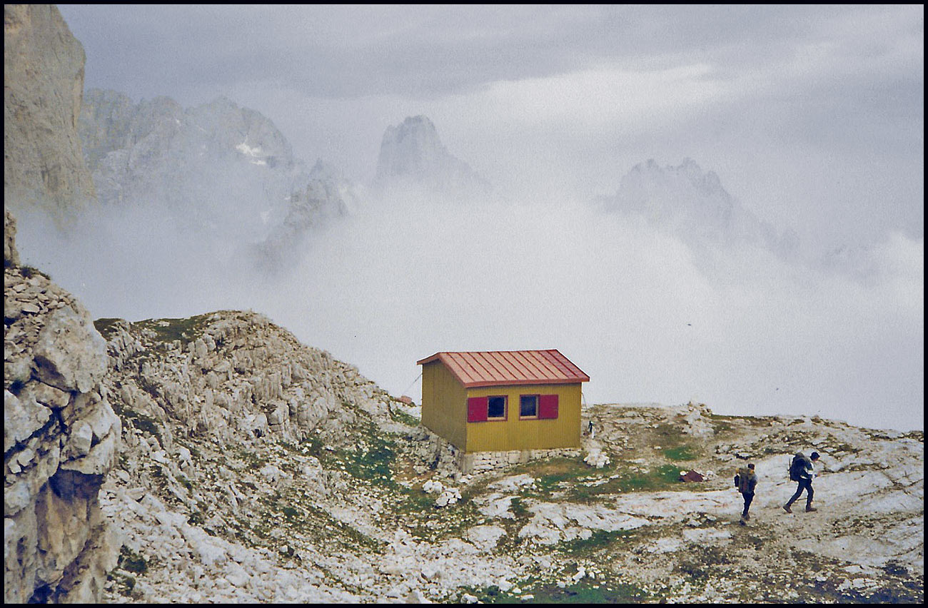
 
 
Some Italians, one lucky chap wearing a yellow "think pink" sweatshirt (?!), and two girls point out a cluster of tents below in the mist. It is indeed the dynamic trio come to rest before Rifugio Treviso. We are quite pleased we don't have to go any further today.


A lot of purility on the campsite tonight. Big bully boy Dave rubs sheep poo into Laurie's hair after cornering the latter in his tent. Revenge for the electric fence joke? If so, it was not matched in subtlety. However, I believe it was Laurie who started flicking bits of poo around to start with, and although I cannot be sure of the train of events, the war probably escalated for some reason. He who plays with fire...
 
 
(Dave adds: Yes indeed - Laurie flicked sheep shit at my dinner - very puerile - though my reaction was a little over the top, I think Laurie enjoyed it!)

Initial calm tonight was followed by rain and blustery wind that died down again by 10:30 pm.
 
 
  Here's our route - 10 km, with 950 metres of ascent. 

Later:
Martin W has kindly provided the following additional images:

                                    Laurie negotiates a wired section
 
A view from near our campsite
 
             Round-leaved Pennycress

Saturday, 5 September 2020

Friday 4 September 2020 - Another Walk Around Timperley and Stretford

Click on any picture for better resolution and access to a slideshow.
 
Sue and I went on this walk on 10 June, when Lockdown was first being eased and we felt we could venture onto the towpath again after three months of feeling uncomfortable there due to the close proximity of cyclists and others. I reported on that walk here.
 
With the possibility of no transport today, I planned our now regular Friday walk to be on the same route. In the event, Sue didn't need the car as she was working from home, and I was joined by three stalwarts - Graeme, Paul and JJ, for the walk from our house, after a brief serving of coffee.
 
The route is virtually entirely off road, apart from the first few hundred metres to the busy (ish) A56 road. Once across the road, we paused at Siddall's Bridge over Baguley Brook. A modern plaque indicates that the bridge dates from 1765, at a time when the Manchester to Runcorn extension of the Bridgewater Canal was under construction nearby.
 
 
A narrow path through Woodheys Clough follows Baguley Brook to beyond where it merges with Timperley Brook and becomes Sinderland Brook and heads off to drain into the Manchester Ship Canal. Thus far, we walked the first couple of kilometres of a 5 km (not)parkrun that Sue and I are in the habit of jogging.
 
 
The path leads past now tired brambles to our local recycling depot that sometimes appears on a TV show called 'Money for Nothing', where the presenters accost people leaving their rubbish and take said rubbish away for conversion into valuable 'goods'. Today we chatted with the 'doorman' and I left him some electrical discards to recycle (including the duff Fitbit Ionic recently reported upon).
 
Our route joined the Trans Pennine Trail (TPT) here, and we continued on through an area of horses, stables and riding schools. Horses are often encountered on this section of the TPT.
 
 
The TPT follows an old road between the high fences of a sewage works. JJ recalled being driven down this road in his youth. Barriers now prevent that, and at this time of year the sickly smelling Himalayan Balsam is rampant in the verges.
 
 
We left the TPT for a while and passed through an area abundant in Goldenrod.
 
 
The 'experimental' path that none of us had been on before passed some solar panels which apparently comprise Altrincham Solar Farm.
 
 
The paths around here are what may be described a 'verdant', or simply 'overgrown'. You wouldn't think that we are on the edge of a large housing estate in West Sale.
 
 
After a while we re-joined the much wider path of the TPT, from where, near Ash Farm, there's a view across fields of crops towards Carrington Moss. I think the area below is next in line for a vast new housing estate.
 
 
We encountered, amongst others, a chap on an electric bicycle a couple of times, always with a map in front of him. He claimed never to have got lost, but was happy to receive advice. He was on grandparenting duty in Timperley, having travelled over from his Lincolnshire home which turned out to be just a couple of miles from my parents' old house in Sudbrooke. We assured him that his cycling route, which was the same as our walking route, would get him back to Timperley in plenty of time to collect his grandchildren from school.
 
We crossed the Mersey via the bridge shown for its Canoe Portage Point in a photo from our previous visit. The re-entry point is just discernible on the left bank in the next picture.
 
 
After a short walk alongside the Mersey in the direction of Stockport (yes Graeme, it's a good walk to Stockport from here!) we passed what I'd previously photographed as a rather barren area adorned with a sign saying 'Coming Soon: Riverbank Coffee, Refreshments and Snacks'. That all looked rather optimistic in June, but they have made it happen, and they had plenty of customers. Well done!
 
 
Our next obstacle, after our own break for coffee/tea and cake (thanks JJ), was the attractive footbridge across all ten lanes of the M60 motorway.
 
 
There was about twice the volume of traffic as shown during our visit in June, but the motorway was still remarkably quiet.
 
 
I'd never been onto Stretford Meadows before. We walked up there for a slightly better view of our surroundings. JJ knows the area and his statement that it comprised an old rubbish tip was confirmed by an obvious vent to release gases, probably one of many.
 
 
A pleasant path leads on to the Bridgewater Canal, before which an area of boggy meadow next to both the TPT and the canal is passed.
 
 
Joining the canal near the Watch House Cruising Club building, we turned right and headed to another bridge over the River Mersey, a spot where if you wait long enough you may be able to spot Kingfishers. Apparently when the canal was being built many folk had difficulty with the concept of a bridge carrying a canal over a river. They thought the water would all drain into the river. Some novel items, including woven fabric, were used to make aqueducts water-tight.
 
 
Here are my companions at this aqueduct.
 
 
Soon afterwards, we passed under the multi-laned M60 motorway. You can see from the sunshine in the picture that there are two separate bridges, one for each carriageway. At this point the canal runs next to the Metrolink railway, which goes under the same massive bridge.
 
 
Some of the 'Cruisers' are beautifully decked with flowers. It's an active waterway and a busy towpath - a great amenity.
 
 
With Sue at home, as we neared the end of our walk I was able to place an order for bacon butties for lunch for the fourth Friday in succession, with tea and coffee thrown in. "Bon appetit" as they say.
 
 
Here's our 16 km route, taking around four hours on this occasion.


Next week, let me know if you plan on joining me, any update will be here:

Friday 11 September: A 20 km walk from Beacon Fell Country Park, going over Parlick and Fair Snape Fell. Meet at the information centre SD564427 at 10 am. Allow an hour and a half from South Manchester, it's on the edge of the Forest of Bowland. Bring some lunch.

Friday, 4 September 2020

29 April 2006 - A Glenbrittle View


After a night in the pods at Auchtertyre, Richard, Jenny, Sue and I made our way in lovely weather to Skye, and the campsite at Glenbrittle.

I may 'in due course' get around to reporting on the whole trip, but here's a taster, taken from a short walk after we had set up camp. Many readers will recognise this view.

Thursday, 3 September 2020

TGO Challenge - Wild Camps (No 31: 22 May 2010)

 
The Loch Tummel Inn had been a great place to rest and refuel. Amanda and Tom have moved on now and the place is currently 'Challenge Unfriendly', but in Amanda and Tom's time it was a great place to stay. Tom's massive breakfast fuelled me for the day. I made my way via Blair Atholl to the Corbett summit of Beinn Vrackie. A few kilometres later I was totally alone at NN979659 at my wild camp by Allt na Leacainn Moine on a fine evening.
 
 
The following morning dawned fine. I opened the tent to see orange early light diffusing through a veneer of mist. It was still there when I took the tent down, then 'the mist thickened and it rained heavily for three hours'.
 

The Death of a Fitbit Ionic


On 1 August 2019 I gave a summary of my 'smartwatch'/'tracker' gadgets - here. The latest addition was a Fitbit Ionic, bought in July 2019. That gadget is shown on the left above. On Sunday it 'died'; all the resuscitation procedures that I could find - "press all three buttons", "press … (a selection of buttons for differing lengths of time)", etc produced just an intermittent Fitbit logo, as shown.

A root around in a drawer found its predecessor, a Fitbit Surge, pictured right - the broken strap reminding me as to why it had been superseded. Anyway, I charged it up and it has worked fine in my pocket for the last few days.

Not pictured, is the Garmin 35, on which I reported in that earlier posting. I've used that as my GPS/running watch since the 310XTs both failed, and it currently still looks and behaves as new. My only niggle with it is that it has a very limited pause time of about 5 minutes before automatically ending the activity, so if you pause it you risk having to start a new activity when you get going again. That's fine for an activity like running, but for a walk with a lunch stop in a pub you have to accept that you have to add together two separate activities to get your stats and .gpx files. I've come to accept that, and overall the 35, linked with Garmin Connect,  is a perfectly adequate piece of kit for a reasonable price.

I haven't needed to use the Ionic as a gps gadget, as the Garmin 35 has done that and has better battery life than the Ionic, so it was a bit of a surprise when the Ionic failed after less than 14 months' use. A call on Tuesday morning to Fitbit support (08000698505) resulted in a ten minute wait, then a twenty minute session with an American operative, going through all the resuscitation techniques I had already tried, and more. At the end of that she simply said "I've sent you an email with your options."

The email duly arrived and gave me the (usual - I've been through this before with Fitbit products)option of a new Ionic watch (just the watch, no straps or charger etc), or 50% off a different product. I chose the former, and it arrived this morning, just 48 hours after I'd reported the failure of its predecessor. I can live with that - the new watch is shown in the centre of the above picture, up and running after being charged up and downloading the latest software.

Hard to spot in the picture is the fact that the removable straps ('bands') are on their last legs, so I should have mentioned that when on the phone to Fitbit. Never mind, I've just thrown them a little petty cash for a new strap to go with the new watch. The cheaper non-Fitbit options all seem to get a thumbs down from their reviewers.

Wednesday, 2 September 2020

Lockdown 2020 stretches into September

 
I've not spent a night away from home since 7 March, thanks principally to Lockdown restrictions. That means I've enjoyed lots of lovely Timperley sunsets from our living room window, like the one above, last Friday (28/8) - taken at a time when the 20/20 cricket at Old Trafford was engulfed by a storm.
 
I was delighted this morning to learn that restrictions on movement imposed on those of us living in Trafford had been relaxed from midnight. So I took the opportunity to deliver cake to Mike and Sarah in Didsbury - with coffee in their garden, then pedal on to visit Cary in his garden in Sale Moor. More cake was delivered*, and coffee was consumed. We had an interesting discussion about LEJOG bike rides, that we are both independently planning. Will that become, at least in part, a Joint Venture? Anyway, we did and can in the future exchange information on this attractive project, but its execution will be 'post-vaccine', and who knows when that will be.
 
By the time I got home around noon, I discovered that the relaxation of movements for the citizens of Trafford had been rescinded and I'm no longer allowed to visit people in their gardens. So it's back to meeting in public parks. I have no idea why this should be less risky re virus transmission than meeting in gardens like I did this morning.
 
En route through Wythenshawe Park this morning, a tree that came apart in some wind a few days ago seems now to being attended to - I suspect the entire massive tree has to be felled.


Regardless of all these rules regarding liberty to move around, I did travel to Staffordshire with Dot after her regular eye injection at Optegra. It's an easy choice - break the rules or let her go blind.

* And the cake was duly consumed by Penny, during a break from her frantic 'working from home' routine.