Sue and Martin in Mallorca 2019

Sue and Martin in Mallorca 2019
On the Archduke's Path in Mallorca

Saturday 20 July 2019

Saturday 20 July 2019 - Wythenshawe parkrun Number 400, and an Unexpected Lunch Ingredient

 
Looks benign, doesn't it? Shortly after this the gazebo made a bid for freedom. No cakes were destroyed. There weren't any today! Had I known in advance, I'd have taken some brownies.
 
Volunteers were a bit thin on the ground this week, so I offered to help, and was positioned as marshal at the far bridge, where on their second lap, the runners have just one kilometre to go to the finish. Jenny and Owen joined me, with what I'd describe as a dinner bell, and we enjoyed cheering and deafening the runners as they flew past.


It rained for a while, then the sun lit the grassy expanses of Wythenshawe Park with a lovely mellow light. The line of runners can be seen skirting the football pitches far into the distance if you look carefully.
 
 
It was the usual sociable aftermath of parkrun - nearly 11.30 by the time I got home.
 
Once 'Slow Syd' had gone past for the second time, I joined the 'Tail Walker' throng to wander back to the start, picking up the object shown below from the side of the path.
 
My plans for what Owen described as "one of the runners has left their brain behind" were greeted with some scepticism. That scepticism was completely and utterly unwarranted, as demonstrated in the following series of pictures:


Delicious!

Friday 19 July 2019

Friday 19 July 2019 - Around Shutlingsloe (again)

 
Paul and Jeanette had never been on Shutlingsloe with a daytime view, their visits having taken place only on the evening walks I arrange every December. So this was their chance.
 
One of my favourite walks is this one from Jen Darling's 'Pub Walks in Cheshire' book. I last did it by way of a recce for Jen's third edition, back in January - here's my report.
 
Today Paul S also came along - we thank him for the lift - and as predicted there was a bit of rain.
 
Ridgegate Reservoir, pictured above, was fairly benign in the drizzle. A cormorant was flapping its wings in a vain attempt to dry them, whilst a great crested grebe seemed to be relishing the weather, and martins were skimming the insects from just above the surface of the lake.
 
Early on the ascent, Jeanette and Paul were showing signs of dampness. Despite her Gore-Tex lined Brasher boots being on only their third outing, Jeanette would soon be able to wring quite a lot of water from her socks.


The summit of Shutlingloe had a little cap of cloud, but never mind, we could see more than on those evening visits in December.
 
New railings have been installed on the steep final ascent to the summit, the first of many recent path improvements that we noticed during the course of the morning.
 
 
Here are two Pauls and Jeanette, peering through the cloud in an effort to catch a glimpse of the Roaches. To their left, we could see across to Shining Tor and the Cat and Fiddle. I took a picture but excluded it from this posting due to 'excessive greyness'.
 
 
We paused for coffee etc at the new metal kissing gate on the descent that I noticed on my last visit, then we passed the Crag Inn (we'd have stopped if half an hour later, when it would have been open), and continued through fields punctuated by brand new gates and signposts.
 
 
The path beside Oaken Clough is very pleasant. It stopped raining here, which seemed to surprise my camera as the next picture came out devoid of the usual rich colours I've come to expect from the S9.
 
 
Oakenclough - a large, smart house surrounded by trees, looks like an oasis from here, with Shutlingsloe lurking behind it.
 
 
A wonderful sunken lane leads down to the Hanging Gate pub.
 
 
Sadly, the place is still closed. There was no work going on today - lots of bits of work in progress visible inside, and a fine decked area below the building.


The decking looks new. Hopefully the place will re-open at some point.
 
Descending from the Hanging Gate, we joined the Gritstone Trail. The 'no sledging' signs have been here for as long as I can remember, but the Gritstone Trail signs are brand new.


From here, it's an easy stroll back to the Leather's Smithy, taking care to leave the Gritstone Trail in favour of a narrow path to the right, shortly after passing between a posh house and a duck pond.
 
Coffees went down well in the pub (thanks, P&J), then we went home for lunch (and in some cases, to dry out).
 
It's a little over 12 km, with about 400 metres ascent, taking three hours at a modest pace. An excellent route, and as noted earlier - one of my favourites, even in today's damp conditions.
 
 
Next week - Friday 26 July:
Around Daresbury - a 13km circuit in 'Lewis Carroll country'. Start 10 am from the Ring o'Bells (SJ 579 829). M56 Jnc 11, A56 towards Warrington, soon turning right into Daresbury.

Thursday 18 July 2019

Wednesday 17 July 2019 - A Lollipop from High Lane

 
SWOG's latest evening walk found us assembling in a relatively small group of fifteen, in a car park in High Lane, on the A6 near Disley. Rain was expected, hence the low turnout.
 
Pam led and Paul took to the rear - except when Sue and Colin took on that position, as we marched along the Macclesfield Canal towpath towards Marple.
 
Bridge number 9 appeared to signal our departure from the canal.


Not so, as over the bridge we went and commenced a battle with wet grass, nettles and brambles on a footpath bordering the canal that was a fraction of the width of the towpath on the other side.
 
After a while we did leave the canal, and we enjoyed quiet paths in the Hawk Green/Marpleridge area. It drizzled for a while; the grass here looks as if it needs a drink.
 
 
Soon the vegetation returned and we passed through an area where the nettles were covered with black caterpillars. I think Conrad has also seen these recently. I believe they are Peacock Butterfly caterpillars - the butterfly is rather more attractive than its caterpillar!
 
 
Soon we reached the canal towpath again. A bit disorientating for those who didn't realise this was a different canal, the Peak Forest Canal, which joins the Macclesfield Canal in Marple.
 
 
Near Strines, we left the canal and headed through fields, back to the Macclesfield Canal, where some remedial works were soon encountered. We must have passed through these earlier without me noticing!
 
 
Then it was a simple stroll along the towpath, passing through a mixture of urban and open countryside areas, and finally being drawn up some steps by the lure of the Bull's Head.


A very pleasant 7 km outing with about 70 metres ascent, taking us about an hour and three quarters.
 
Here you can see why I've called it a 'lollipop', albeit a melting one,
 
 
Thanks to Pam and Paul for leading the throng around this pleasant route.

Wednesday 17 July 2019

Pyrenees HRP - 2004 - Day 6

 
Sue and Martin's Big Adventure
 
Day 6 - Saturday 31 July 2004 -  Stage 5
 
Postcard Summary 
Camp with view to wild camp at Col de Mizpira
Scorching, but welcome beech woods and a long stop (not included in timing) in Les Aldudes – 8 hours, 18 km, 1250m ascent

Scorching hot day.  We got to Les Aldudes by 2 pm and stayed until 4.30, drinking lots, washing clothes, and trying to avoid the heat.  Paddled deeply in a river in order to recover a t-shirt that blew away whilst drying in the breeze.  Then up to a wild camp on a ridge in a breeze, but still very hot – had to hide behind the tent for a while.  Lots of horse bells to lull us to sleep.  Or not!
 
 
Diary Entry (by Sue)
I'm sitting in as much shade as I can find behind the tent, just above a col at 840 metres, after an 8 hour day which was the hottest yet.
 
Despite the vantage point of last night's camp, we were in bed before sunset, and despite the slope we slept till 7 am. A cloudless morning, with a lovely sunrise on the French side, pictured above, with wisps of mist in the valley.
 
We left at 8 am, after a few words with the two girls who pitched their tent just below ours during yesterday evening. It was to be a warm day and was 24°C at 8.30 already!
 
Initially, the path climbed gently through beech woods to a col. Tits sang in the dappled light. Above the trees, a stiff but warm breeze picked up. The beech woods were a big feature of today, and we welcomed the shade when they provided it. We declined a deviation to a summit at over 1300 metres, but visited another at 1119 meters (Sakana), with a big peak visible to the east.
 
There were very steep climbs at times, but beech roots made good steps. Had a brew at Col d'Itchtauz (950 metres), under a beech whose trunk made a windbreak for the stove.
 
The next beech woods had a path deep in leaf litter, and in the shade the rocks beneath were covered with moss. Here, shelters had been made by building walls up against the overhangs of huge rocks. These too, were moss covered. As well as herds of sheep, we came across a couple of herds of goats today. The descent to les Aldudes was long and hot. The temperature peaked at 35°C as we descended, first on a dirt track, then on tarmac.
 
This village has a small hotel, opposite an attractive church, and on arrival at 2 pm, it provided three cokes and a beer to start, then two further cokes!
 
The plan was to stay a while, until it became cooler, then walk for another couple of hours, to reduce tomorrow's over 10 hour day. The village fountain made an excellent washing facility, for our clothes, and us. The wall above the river seemed like a good drying area, except that Martin's t-shirt took off and landed below. Attempts to rescue it using the longer of the two tent poles failed, and he had to wade over (thigh deep) to get it. A different but nevertheless, still effective wall was used after that.
 
In the meantime, the shop at the garage provided an excellent 'lunch' (it was 3.45 pm) of French loaf, pĂ¢tĂ© de campagne and tomatoes, which was eaten whilst the washing dried.  

This was the first time we met any HRP walkers. Three lads were walking the opposite way to us, and stopped to snack, fill water bottles and bandage feet. They only have about 5 days to go! At 4.30 pm, we set off, carrying 4 litres of water to use at our camp. It was still 31°C and we were ascending again!  


In open country, we sweated out a good deal of the water we'd drunk in les Aldudes before deciding to camp just above Col de Mizpira. From here, we can see yesterday's superb ridge in the distance. The hills are hazy but the sky is still cloudless. All that can be heard is sheep, horses neighing, and the tinkle of bells. During our alfresco dinner of savoury rice and tuna, Martin spots the craggy tops of a much higher peak in the far distance - is this near Lescun, our first rest day?

 
Dinner is completed as the sun sinks, with banana angel delight and hot chocolate following paella rice and a tin of tuna - nicer than it sounds. It is still warm enough to be in shorts and t-shirt.

 
A view from the border ridge
 
Looking down towards les Aldudes
 
Beech woods above les Aldudes
 
les Aldudes and its wonderful 'fountain'
 
Goats on the path to Col de Mizpira
 
Hiding behind the tent near hot Col de Mizpira
Stats and route (Viewranger):
18 km, 1250 metres ascent, 8 hours 

 
Index


Our Ullswater Way Weekend - 13 and 14 July 2019

 
This posting provides a pictorial review of our recent weekend in the Lakes, featuring the Ullswater Way. There's also a nice article on the Ullswater Way by James Forrest in the July 2019 edition of The Great Outdoors magazine, in which you may be lucky enough to find a nice picture of me and Sue.
 
My earlier postings are here and here.
 
The pictures are best viewed as a slideshow by clicking on any one of them then moving through the pictures shown as thumbnails at the bottom of the screen.
 
Above - we posed for Richard outside the Ginney Country Guest House near Penrith.
 
We then drove to Dalemain House, where most of the 2500 participants had already set off, starting in waves at 20 minute intervals from about 7 am. The bibs with our numbers also had our starting time, and each batch of people entered the pen pictured below, before 'warming up' and receiving a short briefing. Meanwhile, those arriving could register and collect their bibs. We had done that the previous evening on our way to the B&B.
 
 
Once inside the starting pen, we were encouraged to do some 'warming up' exercises. Sue and Jenny complied; I didn't - it was a warm morning and I'd soon be getting even warmer - I didn't see any point in wasting energy here!
 
 
Jenny wanted to start from the front of our 9.30 am wave, so we got into position.
 
 
And then we were off, some of the last of over 2000 to start, but we'd had time to enjoy a good breakfast at Ginney's.
 
 
After some fields from Dalemain, which I suspect are not public footpaths and are used by the event to avoid bunching near the start, we reached Ullswater and soon picked up Ullswater Way signage, though our route today would vary a little from the official route and was marked by (we were told 800) red arrows.
 
 
We spent the day passing places it would be nice to visit in a more leisurely fashion. Dalemain House and Gardens for one, and soon we passed Waterfoot, another place of interest.
 

The path to Bennethead offered good panoramic views towards the high summits of the Lake District. (Clicking on the image is recommended.)
 
 
After a very well provisioned coffee and croissant etc stop after 4.8 miles at Ullswater Caravan Park, we proceeded along a lovely path through the woodland of Swinburn's Park.
 
 
The previous pictures misleadingly indicate not a lot of people around. Wrong. The path was pretty congested. The three of us were walking comparatively quickly, and we started behind over 2000 other participants. Bunching was inevitable at times on narrow paths where early starters were struggling.
 
Can you spot Jenny and Sue in this picture, and note the human caterpillar ascending Gowbarrow Fell, over 300 metres above the lake.
 
 
Descending from Gowbarrow, the far end of Ullswater - our half way point, came into view in the distance.
 
 
There's a huge jam of people on this descent from Gowbarrow. I took a hidden path in a line just above Jenny's head, but she and Sue tried to follow me they were herded back into a line by a marshal, leaving me with a five minute wait at the bottom of a hill that some found challenging.
 
 
We were soon reunited and striding along to Aira Force, another place worthy of a more leisurely exploration.
 
 
Jenkins Field in Glenridding was set up with a massive lunch tent and a plentiful buffet. The organisation and catering for this event were excellent. Richard and Liz (on holiday nearby) joined us here whilst we lazed for some time at our half way point.
 
 
Then it was past Mike and Marian's house, where someone - perhaps Al Hinkes - was active, Mike and Marian being in the Alps, before taking the wide path to Side Farm and the eastern side of Ullswater.
 
 
Looking back in the direction of Helvellyn, you can make out the caterpillar of people on the Side Farm path.
 
 
We enjoyed great views across Ullswater.
 
 
Two fat ladies were the cause of a very slow single file section.
 
 
Our progress was nevertheless fairly speedy. I would go ahead, dodging around people as best I could, especially on uphill sections where most folk slowed down, and Sue and Jenny would follow, politely asking people to move aside as they needed to catch up with 'the white hat' ahead.
 
Stiles and gates often meant queues where it would have been rude to push in. It was much worse for the many mountain bikers coming the other way, having completed the High Street traverse. I recall doing this with Alastair, expecting the lakeside path back to Patterdale to be relatively easy. It isn't - it's a very technical ride - virtually impossible with a constant stream of Macmillan walkers coming the other way. I felt really sorry for the mountain bikers.
 
 
Eventually we reached Bobbin Mill in Howtown, for more refreshments after 19.1 miles. We'd taken provisions to be on the safe side. They remained untouched.
 
 
The support points ('Pit Stops') were all well provided with toilets, food and drinks.
 
 
After this, we soon left the Ullswater Way route and found the path over Askham Fell to be gentle in its ascent, and conveniently wide. We continued to pass people - we probably overtook well over 1500 other participants during the course of the day.
 
Good views across Ullswater opened up behind us.
 
 
Here are Sue and Jenny with one of the 800 red arrows that we were assiduously following.
 
 
Past a stone circle that I can't see on the map, and over Askham Fell we went, Sue breaking into a run for the descent to Askham, during which our objective, Lowther Castle, came into view.
 
 
It was somewhat challenging to walk past the hostelries of Askham. At least Richard wasn't sat outside with a beer!
 
 
We descended to the River Lowther, where my companions are seen from the same place as the next picture was taken. They were doing well at keeping up with the white hat!


Richard was at the finish to capture this shot of the Happy Hikers crossing the line after nearly 26 miles and 9.5 hours. It was 7 pm and we were in positions 204, 205 and 206 based on chip times, out of about 2100 finishers. But we definitely weren't 'racing' - I think the 'chip' timing was more for the purpose of keeping track of everyone.
 
 
We got medals, and could have got a meal here, but after some statutory photos to record our success we went back to Ginney's for a shower, then to the Boot and Shoe in Greystoke for a nice meal.
 

Here's the route - 42 km (26 miles) with about 1100 metres ascent.
 
 
Sunday offered the opportunity to walk the section of the Ullswater Way we missed on Saturday - Howtown to Pooley Bridge. Just a short walk, so we could enjoy a leisurely breakfast and departure from Linda and Philip's Guest House (Ginney's).
 
 
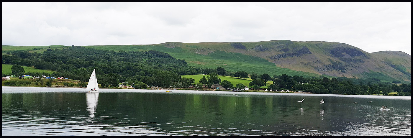
Here's the view over Ullswater from Pooley Bridge whilst we waited for Raven, the old steamer (now diesel) that takes passengers to various points on the lake.
 
 
A little later, we were on the boat, with a view across to the glamping pods and tepees of Waterside campsite.
 
 
It's not a long journey to Howtown.
 
 
After coffees in the tea room, we set off in search of the signposted Ullswater Way route, passing Foxgloves and Silverweed.


This old bridge should have led to the correct path. But it just went to a dead end.
 
 
Once you find the signs you can't really miss them - the Ullswater Way is a newish route with excellent signposting.
 
 
If lost, you could always make an emergency call!
 

The camp shop at Waterside saw to our needs, which in Sue and my case were minimal as we still had yesterday's lunch to eat, and we enjoyed a leisurely lunch on a good picnic bench.
 
 
Then it was a simple matter of strolling into Pooley Bridge, and a journey home switching between cricket and tennis on the radio.


Here's our route - 7.5 km with not much more than 100 metres ascent, taking 2 hours plus breaks.
 
 
Whilst composing this entry I've had the pleasure of the whistling company of swifts preparing for their long journey to Africa. Whilst those that nest in our eaves didn't make it this year, some of the local population do seem to have maintained their routine, and the youngsters are in serious training for their long journeys.