Sue and Martin in Mallorca 2019

Sue and Martin in Mallorca 2019
On the Archduke's Path in Mallorca

Saturday, 22 August 2015

The Alps - Day 4 - Dornbirn to St Anton to Berggasthof Bodenalpe, beyond Ischgl


Saturday 22 August 2015

50 km, 1730 metres ascent, 7.25 hours including about 2 hours breaks.

Weather: sunny periods and warm - perfect for mountain biking.

It was good to finally be in the mountains after the long drive through fairly nondescript countryside, blighted in Germany by numerous motionless wind turbines, standing in silent groups like monstrous sculptures.

After driving up to St Anton (50 miles, 1.4 hours), our seven TransAlpinistes, already reduced from eight by Dieter's illness, assembled for the off:

Rouven, our guide
Markus, assistant guide and 'Tail End Charlie'
Daniel, Thomas, Emanuel, Claudia and me - the tourists.

Having met Rouven at Dornbirn railway station at 7 o'clock, by the time we had assembled at St Anton we were in need of a breakfast. So after riding for about 1 kilometre we wisely stopped. For breakfast. Very nice it was too. Coffee and bread and butter.

Then we set off at 9.45 past masses of people about to set off on a mountain bike race. That was the last we saw of them. They weren't going in our direction. Unlike my 2010 TransAlp when Markus and I found ourselves ahead of the peleton.

The long ascent up the pretty Schönverwalltal valley was easy for most of the way. Frequent stops for photos were in order. Conditions were as good as they get. I was at the back, but not too far behind.

The rough track eventually turned into a muddy rocky path. This is my territory and I was soon tracking Rouven and moving steadily ahead of the others, who were pushing or carrying sections that Rouven and I were attempting to cycle. Rouven was more successful at that than me, but I was pleased to be enjoying the technical ascent.

Eventually we we forced to push for part of the way up to the Neue Heilbronner Hutte at 2300 metres. Those behind me were baulked by cows.

it was nice to have lunch at the Hutte without the smell of muck spreading wafting over the sandwiches, as it had done on my picnic stops during the journey to Dornbirn. 

The descent to Ischgl - a good 20 km, was almost entirely downhill, mostly off road. Absolutely brilliant.

Ischgl provided a bike shop into which several members of the party rushed their bikes. Repairs and maintenance were duly provided, much to the relief of Daniel and Markus in particular.

We all enjoyed coffee and applestrudel or coke and cake or whatever, in a nearby café.

Then a thrutchy (don't you just love that word) ascent on steep tarmac led up another 500 metres to this fine mountain guest house at above 1900 metres.

5 pm. Beer o'clock. Then a leisurely evening with an excellent meal - fridatten soup (pancake strips in beef stock), schnitzel with a lovely cream vegetable sauce and pasta and salad, then a cake and cream dessert.

An excellent start to the trip. It's a really good group to be with. We have bonded well and are ensconced in two very smart and well equipped rooms for four.

I won't mention the sleeping arrangement for want of causing a scandal.

Today's pictures:
Milling around in St Anton
3 pictures taken during the Schönverwalltal ascent
Berggasthof Bodenalpe

Next Day
Back to Index

Friday, 21 August 2015

The Alps - Day 3 - Heidelberg to Dornbirn


Friday 21 August

It's worth visiting Andrea and Thomas for the breakfast alone. I think the presence of a visitor inspires them to visit the deli, the bakery and the cheese shop and come away with all manner of mouthwatering meats, cheeses and breads. Thanks go to them for looking after me in such fine fashion.

During yesterday's walk I expressed my disappointment that they weren't taking advantage of the great bike trails around Heidelberg. They must have anticipated my comments as today they both have a day off work and will tour the local bicycle emporia in search of hybrid cycles. Andrea may even get one with an added electric motor - such bikes seem to be increasing in popularity.

By 10 o'clock I was on my way on the very leisurely drive to Dornbirn - another 230 miles, bringing the Timperley to Dornbirn tally to 970 miles. It's a good job I quite like the occasional long car journey!

Dornbirn - sunny, 26C hot, 4 pm, coffee with Markus. He has a brand new bike. We are both excited about TransAlp 2015.

We quickly adjourned to the Fetz Restaurant for dinner with a view to the peaks of the Bregenzerwald, before returning to Markus's apartment for an early night.

The pictures:
Breakfast
The Bregenzerwald from the Fetz Restaurant

Next Day
Back to Index

The Alps - Days 1 and 2 - Timperley to Heidelberg


It started with a trip to the dentist, as planned. A long root canal session was abandoned in favour of running repairs, with Afzal being particularly meticulous in front of a student nurse who was practicing on me.

Meanwhile, I was worrying about how I would manage for three weeks without this phone. I'd intended heading straight down the motorway after my teeth had been sorted, but a trip home eventually located the phone in a drawer into which I'd shovelled the contents of my desk and a load of bubble wrap that must have muffled the phone when I rang it from the house phone. I'd left myself five answerphone messages!

The journey to Ashford went somewhat better. Even the M25 was moving smoothly. I finished up on le shuttle an hour and a half earlier than my booked time.

Time that I lost around Dunkerque driving around searching in vain in the dark for the hotel I'd booked. I even resorted to a McDonalds for food!

The 'Premiere Classe' was in name only, but it was at least clean and quiet.

And, whilst composed of basic ingredients, the breakfast was of the 'enjoy as much as you can eat and drink' genre.

A warm, sunny day was quiet on the roads apart from a short stretch around Brussels where some lorries had exploded. Heidelberg was reached after 400 miles, at 4.30pm, via some autobahns that confirmed that the Skoda can't quite reach 250 kph. Andrea's kettle and tea pot soon provided necessary sustenance.

Thomas arrived home from a stressful day at work (problems with two ink colours) and we all relaxed into a 9 km stroll through the woods and down to the River Neckar.

Klosterhof Heidelberg wheat beer preceded a delicious pasta and salad back at base. Meanwhile, in Timperley, Sue was ferrying hanging baskets and tubs of flowers to various friends for 'watering' during our absence, Andrea and Thomas having moved too far away to carry out the house minding duties to which they had become accustomed as neighbours of ours in Timperley.

So far so good... The bike is still intact in the boot of the car.

The pictures:
Top two - taken from the same place near Ashfotd
Andrea and Thomas and the village outside Heidelberg in which they now live
The map that Andrea insisted I include, showing Heidelberg as the walking capital of Europe. ...

Next Day
Back to Index

Wednesday, 19 August 2015

A TransAlp Bike Ride

10082628descent3

It’s all go.

I’m just about to set off from Timperley to take part in another TransAlp bike ride.

Just by way of a point of reference, the record of my 2010 ride is here, and in the above photo.

This trip promises to be a little more sociable than GR11!

Next posting

Sunday, 16 August 2015

Sunday 16 August 2015 – Bike Ride – Marple and Lyme Park

1602LymeHall2

The reason for all these bike rides will become apparent shortly. Today’s outing from Rose Hill in Marple was on yet another lovely sunny day, but thankfully lacking Pyrenean style heat, pressure sores and all that jazz.

I headed for over 6 km down the Middlewood Way, together with a large congregation of walkers, runners, horse riders and other cyclists. We did actually congregate for some time whilst a farmer moved his herd of Guernseys from a field on one side of the track to one on the other side.

Zooming past Higher Poynton Station, where previous rides have left the old railway line at Nelson Pit, I overshot the next exit and did a few ‘there and back’ kilometres before leaving the railway at a small car park after getting stuck for a while behind a fat, deaf man on a very slow bike, and heading down under the canal and up a hill. Doubling back to the left took me to the bottom of a hill, where a gate to the right (the West Gate) offered access to Lyme Park, and a steady pull up a rough track to another gate.

Beyond here, tarmac leads to the Hall, pictured above. This cycle route goes fast past the car park before doubling back to the right to face the hall as shown, looking back at the shocked faces of those who have just nearly been decimated by the silent but deadly Stumpjumper (my bike – the bell does work but people don’t seem to hear it).

Further up the hill the tarmac gave way to a stony path with views across Cheshire beyond the square hunting lodge on top of a hill that can be seen for miles around.

1603LymePark1

The track drops down to the East Gate, then a rough section goes down to the old bridge shown below. This bridge has recently been deemed unsafe for vehicular traffic by the Highways Agency. A footpath, on which my bike is positioned, has been constructed to by-pass the closed road. This is no good to horse riders, nor to the farmer who travels by Land Rover to shepherd his herd of sheep. So the fence erected to block the road is constantly being pulled down. Apparently some locals think it should have been demoted to bridleway status and not closed off, though that still wouldn’t be of much help to the farmer. The footpath proved too narrow for both me and my bike, resulting in a few skin rips from Stumpy’s sharper protuberances.

1607bridge1

A steep push from the bridge over slippery rocks led to roads (turn left at the first road, then right at the junction) that traversed high above New Mills and Furness Vale, dropping eventually towards Whaley Bridge.

There were fine views down to New Mills and across the valley to Kinder Scout.

1610kinder

A fairly obscure bridleway* took a left past a 4x4 that was virtually blocking the rose bush lined route (more scratches), just before entering Whaley Bridge. This leads down to Furness Vale, where the Peak Forest Canal provided my next conduit. I could alternatively have taken the road into Whaley Bridge and picked up the canal there, but it wouldn’t have been as much fun as on the rocky paths I took.

The towpath passes large mooring areas before reaching New Mills and passing the unmistakeable aroma of Love Hearts emanating from the sweet factory, pictured ahead in the next image.

1613sweetfactory2

I turned right at the first bridge after the sweet factory, along a track that led down then up to Hague Bar. Straight across the main road there, and the last serious climb of the day took me at walking pace behind a couple of nervous hikers who thought they were about to be run over, up to the metal bench by Brook Bottom.

Turning left, I eschewed a visit to the Fox Inn, in favour of a cuppa in Marple with Graham and Sue, after returning to Rose Hill by the same bumpy route as described in my last report on Wednesday’s outing.

Here’s my route - 35 km with 700 metres ascent, taking nearly 3 hours.

1699route

* On the descent to Whaley Bridge pass a house on the left where there’s a Public Footpath sign. A few metres further on, by the next house, is a bridleway sign. Take this bridleway down steeply between rose bushes and houses then turn left down a fast, narrow path to a gate. Continue along a grass track, keeping at a contouring height and not dropping down to another gate. After rising slightly, the grass track turns to stone and descends to a stream and gate. Beyond here a narrow rocky path leads to tarmac, and the descent to Furness Vale.

Thursday, 13 August 2015

Wednesday 12 August 2015 – A Peak District Bike Ride

1201bullshead-(1)

What a cracking day for a bike ride.

I pootled off to Marple, intending to start the ride from the car park by the Midland Hotel in Marple Bridge, but roadworks encouraged me to park up before that at Rose Hill.

So instead of heading of down the Peak Forest Canal as planned, I decided to make this a ride of two halves, starting with the flat half.

I took the Middlewood Way as far as Nelson Pit (toilets), easily identified by the station platform and a large picnic area where the tracks used to be. The steps up to the left from the Middlewood Way are the only good reason to dismount on this entire ride.

A few metres up the road to the south east you join the Macclesfield Canal at a very busy marina where refreshments are available. The well surfaced towpath then leads easily to High Lane, where the Bull’s Head, pictured above, has often been used as a starting point for our evening walks.

A right turn in Marple brought me to the Peak Forest Canal, heading towards New Mills, where the sweet factory was producing some alluring smells. Here’s a typical view from the towpath.
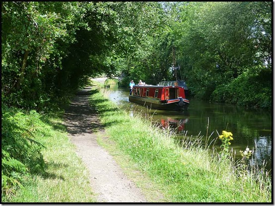
1202PFcanal1)

A little further on, one of the several drawbridges and swing bridges on this section of canal was being renovated. I asked them to pose for me, New York style, sitting on the top girder eating their lunches, but they didn’t seem too keen.
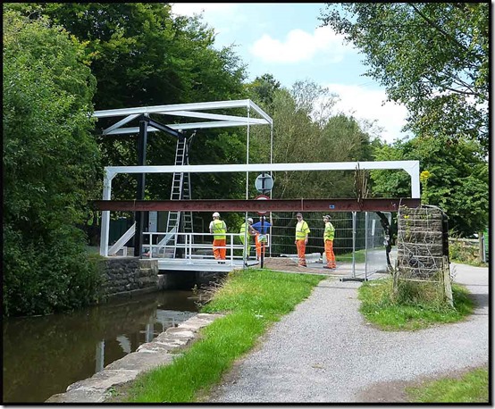
1203PFcanal2

A spot of sunbathing whilst waiting for the drawbridge to open seemed in order.

1204PFCanal3

It was a hot day on the towpath, with good views across to a viaduct, home to one of many railway lines hereabouts. The following two pictures were taken from the same spot.

1205PFCanal41206PFCanalview

A pause for a cuppa after an hour in the saddle saw me on a bench chatting to a stranger who was feeding the ducks. This is a pleasure (chatting with strangers) that’s so much easier now I’m back from the Pyrenees!

I’ll describe the rest of the route at the foot of this posting, but the second half of the ride – the hilly half – started at Furness Vale where a steep descent led to a 200 metre ascent to the high point of the ride (point 326 metres on Over Hill Road). The only photo I took doesn’t really capture the perspective. I am 200 metres above the bottom of the valley.
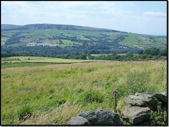
1207viewback

It was a lovely fast descent to Birch Vale, despite a minor aberration at Moor Lodge where I turned left by mistake. Then the Sett Valley Trail led to a steep ascent out of New Mills, past a care home for dementia sufferers outside which I enjoyed the rest of my tea and a banana, the reward for two hours of riding.

After rising steeply on tarmac to New Mills Golf Club the descent to Brook Bottom was down the steep stony track that I struggled up on Sunday. It’s much easier in descent! Then down to Brook Bottom and very slowly behind a trailer on which a man was sitting, trying to restrain a large fridge.

“Mountain biker killed by flying fridge” was his headline warning, but by the time we got to the top of the hill I was suggesting “fridge outpaces mountain biker up gentle slope”.

I took the fast track alongside the top of Mellor Golf Course, then the stony track down to Bottom’s Hall for a joke with some lads who were trimming the hawthorn and bramble hedge. After a brief ‘carry’ to avoid a puncture it was then a quick return to Rose Hill on the route described below.

I’d run out of tea, so refreshments at the excellent Railway pub at Rose Hill were most appreciated.

Here’s my route – just shy of 40km with about 500 metres ascent. It took me a leisurely three and a half hours including breaks totalling over half an hour.

1299route

The route:

Park near the access point to the Middlewood Way near Rose Hill station in Marple.

Take the Middlewood Way for nearly 6 km, leaving it sharp left up a stepped path by the picnic spot and old platform at Nelson Pit. Toilets are straight ahead after leaving the old railway track.

Turn right to reach the Macclesfield Canal and follow the towpath for nearly another 6 km, crossing a bridge in Marple to reach the towpath of the Peak Forest Canal heading in the direction of New Mills.

Soon cross to the left hand side of the canal and continue for about 8 km as far as Furness Vale, where you leave the canal after a large area where barges are moored on the other side of the canal.

[You have just been cycling along part of a 3000 mile walking route, European route E2, between Galway and Nice!]

In Furness Vale, look right to a level crossing to check you are in the right place, then bomb down the hill to your left and follow the road sharp left at a bridge. A few metres further on, engage a low gear and turn sharp right up Ladypit Lane which rises to a right hand bend where it turns into Dolly Lane. The lane undulates before climbing quite steeply to a high point where a narrower lane goes left up past Laneside Farm.

Follow this narrower lane steeply up to its high point at 326 metres*.

Then relax over the undulating if rough terrain followed by Over Hill Road, to Moor Lodge. Don’t make my mistake of turning left here, but follow the tarmac at breakneck speed to a sharp corner that brings you out at the main A6015 road in Birch Vale.

Turn right, and then first left. Continue down the hill, about 100 metres before the bottom of which a gate on the left introduces you to the Sett Valley Trail.

After about 1.5 km, turn right at a road, then left at the next junction. About a kilometre later, turn sharp right, steeply up Watford Road, past the dementia care home, to a junction where you go straight across and follow Apple Tree Road all the way to New Mills golf course.

Continue straight over Castle Edge Road and along the wide track, taking a narrower track to the left when the wide track forks right.

Take care on the rocky descent to a metal bench on Brook Bottom Road. Turn right to reach the Fox Inn.

There are numerous options from here, but the route I chose on this occasion follows the road through Brook Bottom and up a gentle hill beyond which it becomes a track. A right fork brings you gently up to Mellor golf course, alongside which you continue until just before the club house and car park, where left turns take you to an initially fast descent to a rough track leading over steadily rockier terrain to Bottom’s Hall.

Continue towards Bottom’s Bridge, before which you turn right past mill renovation work up the rough track that is Low Lea Road.

Descend pleasantly into Marple Bridge, where a left turn takes you down to the traffic lights. Turn left here, then first right into Brabyns Park.

Past the car park, take upward tracks that double back a little to cross the railway and reach the Peak Forest Canal. Turn right at the canal then cross it at a narrow bridge by the next lock down.

Go straight ahead up a narrow dirt track that brings you out on Grosvenor Road.

Now follow Grosvenor Road to a left turn up Oakdene Road and another left turn along Manor Hill Road. A right turn at the main road brings you in sight of traffic lights where you bear right onto the main road to Stockport, soon after which you cross the railway bridge and turn left beyond the Railway pub to return to the car park.

* There are lots of potential variations to this route, one of which involves turning right at point 326. Soon afterwards turn left onto a bridleway and stay on this path all the way over Chinley Churn, up to about 430 metres. Finish up on a flattish grass and rock track between two walls. Where the left wall goes left, follow it and then head diagonally down across a field to a gate, where you join a track and descend to a road, across which you rejoin the route I followed today just before the Sett Valley Trail turning.

Wednesday, 12 August 2015

Tuesday 11 August 2015 – A Reunion of TGO Challengers

1101tgo

It’s always good to meet up with friends who are also TGO Challengers.

So when Mick and Gayle were passing by it was good to meet them and exchange some Pyrenean yarns – they were walking GR10 in France whilst I was completing Spain’s GR11 route. Gayle’s record is here.

Gayle’s camera drowned during their GR10 walk, so Mick found some unsuspecting strangers to try to enrol into the ‘TGO Family’ and on which to test a new type of camera that he’s now thinking of acquiring for Gayle.

1101group

It was a pleasant afternoon in Cheshire, with good views towards the Wrekin and the hills of North Wales.

1103view

Just for the record, we walked a little over 6 km, with 250 metres ascent, in around an hour and a half.

A lovely stroll followed by tea and cake in Colin (M&G’s campervan).

I expect you can all guess where we were…before I add the relevant ‘label’?

Tuesday, 11 August 2015

Sunday 9 August 2015 – Mellor Moor

0901FoxInn

This posting is really to record a 1.5 hour bike ride route from the car park above the Midland Hotel in Marple Bridge. It’s easier to park there than it is to drive down the potholed road to Roman Lakes, although the ride is based on Roman Lakes’ route M1 – ‘Mellor Moor’.

It was a lovely morning for a ride – warm, sunny and calm, and this route has some proper hills.

Start by heading up past the station and taking the first left along Arkwright Road. Then turn left down Paywood Drive which leads past Bottom’s Bridge to Lakes Road and Roman Lakes Leisure Park. This is an alternative starting point with a small café and toilets.

Continue along the track, through a railway tunnel, past a farm building, and along a rough bridleway beside the railway to another farm, immediately before which turn left up a broken road which levels out after a few hundred metres. Turn right up another steep track that ends at a steep junction. Turn right* here – the track passes some houses then becomes a narrow path that soon joins a small road. Bear left up the road and over the top before dropping down to the hamlet of Brook Bottom.

If you time your visit correctly, you’ll struggle to pass the Fox Inn without pausing for refreshment. It’s looking much better than it did in September 2009!

1807fox2

Beyond the Fox, engage low gear and continue along the road for 200 metres to a metal bench from where there’s a good view across the valley to Disley and Lyme Park.

0902view1

Take a deep breath and turn left at the metal bench, up a steep stony track. I challenge you to ride this section without stopping. I wasn’t able to today, but a much stronger rider passed me and managed it without difficulty.

At the top of the track a left turn along Castle Edge Road allows you to rise more gently to good views across to Hayfield and Kinder Scout to your east.

0903view2

The road turns into a wide track at the top of the hill, from where an enjoyable descent leads quickly to a junction where you turn sharp left along more tarmac.

Follow this road for nearly 2 km up to a point where a large wooden cross is above you on the left and a very loose rocky track (Black Lane) comes down steeply from the left. Turn right here, down a steep lane that becomes loose at the bottom. Before a gateway into a garden you turn right down a loose path with wooden drop offs (care!).

50 metres further on turn left down a narrower, looser path next to a fence and emerge at the bottom between houses. Turn right down the track and to reach the steep track at the junction where you turned right earlier*.

Retrace the route steeply down, but now turn right at the bottom at a T junction. Continue for 100 metres before taking a narrow track to the left between hedges. At the bottom of this track, turn right along the stony track that leads back to Roman Lakes and refreshments if you need them.

From Roman Lakes, return towards Bottom’s Bridge, before which a right turn along Low Lea Road past the mill renovation works takes you up to a point where a fast descent leads to the tarmac of Town Street in Marple Bridge. Turn left at the lights to return to the car park.

An enjoyable little jaunt with some mildly technical sections – about 15km with 400 metres ascent. Allow an hour and a half.

0999route

Here’s the Garmin file for this route:

Monday, 10 August 2015

Friday 7 August 2015 – A Bike Ride from Rose Hill

0201TPT

The picture above is a ‘prologue’, taken on 2 August, the day after I returned from the Pyrenees, on the Trans Pennine Trail in Stretford.

Whilst it was hot and dry in the Pyrenees, the greenery indicates what the weather has been like at home. The picture is to show Markus that I’m trying to prepare for the next trip!

After a few local rides on the flat, I decided I needed to go up a few hills. The most convenient hilly routes are from Marple, so on Friday I pottered off to Rose Hill Station, from where there’s a nice flat warm-up along the Middlewood Way.

After nearly 6 km you reach Nelson Pit and the Boars Head, where we were on Wednesday. You can carry on further along the Middlewood Way, which is well served with cafés and toilets, but I left it here and pedalled a few metres east to the Macclesfield Canal.

0701macccanal1

Again, it’s pretty flat all the way back into Marple.

0704macccanal4

The only hills involve tight manoeuvring over narrow bridges where the towpath moves from one bank to the other.

In Marple I turned right down the pretty Peak Forest Canal.

0706pf2

Soon after the drawbridge shown below, some steps lead down to the left (in fact the right, behind the camera, as this photo was taken looking back). I should have been able to descend these steps easily on the full suspension bike, but I chickened out.

0708drawbridge2

A steep descent crosses the main road and heads up towards Strines Station. Shortly before that, a left turn also rises sharply to a farm and a slightly technical bridleway past another farm to Roman Lakes.

Beyond the potholed Roman Lakes track, a right turn up Low Lea Road takes you past a Lottery funded mill restoration project and over a hill to Marple Bridge.

Left at the lights, then first right into Brabyns Park leaves the rider with a choice of uphill options and dead ends to regain the Peak Forest Canal in the middle of the Marple Locks system. Beyond that it’s worth pedalling on over the aqueduct as far as Romiley tunnel.

0709aqueduct10711plaque0713tunnel2

Then it’s back along the towpath to cross the canal between the fifth and sixth locks from the bottom of the system, and a route back to Rose Hill along minor roads. (Or you could simply go along the canal and turn right along the A626 to return to Rose Hill.)

A good couple of hours’ scenery and exercise, if a bit sparse on the ‘hill’ front. That will come later…

27 km, 300 metres ascent, taking about 2 hours.

0799route

A pleasant outing on the bike; basically a warm-up for something a bit more challenging. I’ve not marked my start point (Rose Hill), but there are numerous places from which you could start this ride.

Enjoy!

Sunday, 9 August 2015

Wednesday 5 August 2015 – An Evening Walk with SWOG from Nelson Pit

0505nrElmerhurst

A mottley crew of about thirty assembled outside Nelson Pit Visitor Centre for a 7.30 pm start.

Up by Windgather there was rain in the air. “What are you lot up to?” mooed the lady on the right.

0504byWindgather2

One rickety stile; thirty people.

0507byElmerhurst

The leaders ploughed on through wet grass towards Disley.

0506towardsDisley

Back at the Macclesfield Canal, we found a tractor festival.

0508tractor10509tractor2

This is my favourite:

0510tractor3

By now the light was a little on the low side.

0512MaccCanal1

But we soldiered on bravely and reached the Boars Head before it went dark.

0514BoarsHead

Here's our route - about 7 km with 100 metres ascent. Allow a good 1.5 hours.

0599route

There’s a very short slideshow here.

We did another walk from here on 30 July 2014. It’s a good place to start from.