Sue and Martin in Mallorca 2019

Sue and Martin in Mallorca 2019
On the Archduke's Path in Mallorca

Friday, 4 March 2011

A Grand Day Out

The first few days of March have seen a welcome change in the weather, and my first trip of the year to the central Lake District.

Here I am near the summit of Great Gable on Wednesday lunch time.

A view from Great Gable - 2/3/11

A write up of that day and others in this enjoyable week will follow during the course of next week, as we are due to depart shortly for a few internet free days, plus we have a visitor who deserves better than to be abandoned in favour of a computer desk…

Thursday, 3 March 2011

Sunday 27 February 2011 – A Walk from Home

Forsythia by the Bridgewater Canal

Last Sunday I abandoned a plan to stroll around The Wirral, due to inclement weather.

An easy bit of exercise around Timperley in the rain was in order.

Whilst the Forsythia (above) was flourishing, I don’t think I’ve ever seen the towpath in such a poor state of repair.

Mud in Timperley

Sunday morning means training at the local rowing club.  Their oars can be quite dangerous to wildlife.

A scene on the Bridgewater Canal - 27/2/11

But these Mallards seem quite happy with life.  The female is impressively fertile judging by the increasing number of albino ducks on this stretch of the canal.

Mallards on the Bridgewater Canal

Leaving the canal by the Bay Malton, I joined the Trans-Pennine Trail, which soon passes our local ‘recycling plant’ (aka rubbish dump, or ‘tip’).

Recycling in Altrincham

The trail progresses on to Carrington Moss, home of training grounds for local football teams.  It’s quite damp at present.  It is after all a ‘moss’!

Carrington Moss

After passing a Sustrans team of volunteers, assiduously manicuring trees beside the trail, to avoid cyclists being speared by wayward twigs, I left that trail in favour of a path beside the River Mersey.

The River Mersey by Stretford

Judging by the debris on the fence (above), the path I was on, not an official Right of Way, must spend some time under water.

By the Mersey in Stretford

After passing this flourishing willow as the path narrows around the rear of an industrial estate, a dead end is encountered when the A56 main road is reached.

Willow - 27/2/11

Across the road, paths around playing fields lead back to the canal where it passes under a motorway bridge.  The towpath here, between Dane Road and Sale, is in great condition, having recently been renewed as part of the Sustrans initiative.

Sustrans were here! The towpath by Dane Road, Sale

But the section from Brooklands to Timperley was extremely muddy, and I was filthy by the time I reached home.

Here’s my route – about 17km, in a fairly energetic 2 and a bit hours.

Today's route - 27/2/11 - just over 2 hours for 17km on the flat, with mud...

Tuesday, 1 March 2011

A Timperley Sunrise

Sunrise over Timperley - 11/12/07
It’s an early start tomorrow.  It would be nice to get a sunrise like this one on 11 December 2007.

Monday, 28 February 2011

100,000 Page Loads! And a New Look to the Blog

 2803stats  
I’ve used Statcounter to record page loads since I started this blog in October 2007. I know that some bloggers (OK, maybe not UK Outdoors Bloggers!) get over 100,000 page loads every day, whereas it has taken nearly three and a half years for this one to reach that milestone. Google’s own stats, which only started recording data fairly recently, give higher figures (3,404 page loads compared with Statcounter’s 3,334 for last month). Those people using a service such as Google Reader to view the blog will escape detection unless, like the three people last Wednesday (see below) they then go into the blog, to make a rare comment for example.  So given that currently the blog has 84 subscribers and 46 ‘followers’ (some or all of whom may be subscribers?) the actual number of people looking at the blog is rather greater than that recorded by either Statcounter or Google.

Visitors seem to average about two page views. Most of them simply arrive at the current blog posting and presumably scroll down if they aren’t bored by the first screen. Others arrive via searches, mainly ‘Google’.

Another Statcounter page dump

Last Wednesday, with 119 page loads, was a typical day.  They can be analysed as follows:

Direct page loads from friends and known contacts 23
Via Google reader 3
Via other bloggers' blogrolls 33
Via our sister site, topwalks.com 5
Via Google image searches 33
Via Google etc searches for recipes 9
Via Google etc searches for the TGO Challenge 5
Via Google etc - other searches 8
  119

That obviously excludes the visits to Google reader and other subscription services.

It’s interesting (to me anyway), that our other website, topwalks.com (not a commercial site – just one that friends can view to see what we are up to) gets nearly as many page loads, more on some days, despite only being updated every month or so. 

So it is with some satisfaction that I observe that both sites are clearly used by people as a resource.  It’s a shame that so few make contact by way of comments or emails.

A New Look

A new look to the blog

Last week I tried to change the blog list to reveal current posts of interest, as I noticed that quite a few visitors to the Postcard come from that direction, so ... just to be fair...
but I played with the template and pressed the wrong button! I tried to get the old one back but I couldn't find it!   There is no record.  It’s history! 

This time I’ve taken a screen dump (above) and I think I'll stick with this template for a while, but I may change the header, footer and background images on a regular basis.  At least this new template enables slightly wider images to be loaded.

Any comments / suggestions for improvements will be welcome.

Postscript:

1.  Does anyone agree with this comment from Andrew - “the use of some very blue landscapes as background down the right hand side makes a lot of the text difficult to read and some impossible”.  Personally, I don’t have a problem, and I spent some time trying to find an image that didn’t cause me a problem!  But if it is a problem, I’ll change the background image, which I’m planning to do quite regularly anyway.

2.  Theo has asked about the geographical spread of visitors, and the following screen dump shows the spread for the last 500 page loads as at the morning of 3/3/11.  The Hungarian page loads come from just one visitor with a fascination for our 2008 TGO Challenge postings, so that’s just a blip.

Statistics by Country

Saturday, 26 February 2011

Spring Flowers (2)

Anemone and Cyclamen 
It had been a couple of weeks since we’d last been down to the winter garden at Dunham Massey. The sun was shining. It was Sue’s birthday. SaHH (Stay at Home Hazel) was progressing well with her current assignment.

No excuse not to visit the garden, then. And here’s some of what we saw; the winter flowers (the identities of which we didn’t note) are coming on a treat now it has warmed up a bit. It was also good to see bees being very numerous and active in some of the flower beds.

The gardeners keep these birch trees nice and clean to match the Snowdrops

Ladybird

Tufted Duck

A Garden Flower

Iris

Iris

A Garden Flower

And in our garden the blackbirds are singing - are they in love?  The wood pigeons certainly are.

Friday, 25 February 2011

Wednesday 23 February 2011 – A Slide Show – ‘Far West of the USA, from Arches to Yosemite’

Sue and I were pleased to be asked by Stockport Walking Group to present our fourth slide show to them tonight.

We had originally planned to cover more, but in preparing the material we realised that we couldn’t do justice to the content in just one hour, so we hope we didn’t disappoint the thirty strong audience by leaving the National Parks accessed via San Francisco – Yosemite, Kings Canyon and Sequoia, to another time.

Our trip to the USA in September 2003 saw us landing at Las Vegas and heading off to Zion,

Zion National Park - The Narrows

then Bryce Canyon,

Bryce Canyon National Park

then Arches, via Moab,

Arches National Park - North Window and South Window

then Canyonlands,

Canyonlands from near Dead Horse Point

and finally – via Monument Valley and Navajo – The Grand Canyon.

The Grand Canyon, from the North Rim

This was an old fashioned slide show, with images from before the days of good digital cameras, and I think that the quality of those images is better than the ones in our digital slide shows. But, they can’t be cropped or blown up, and we seem to take a better ‘range’ of pictures with the digital cameras.

Anyone wishing to see this show would be most welcome. There are 100 images, it takes less than an hour, and we have lots of maps and additional information that may be of interest to anyone considering a visit to these National Parks. We enjoy doing this, and don’t make any charge.

Wednesday 23 February 2011 – The Salford Trail (Part 2)

LDWA walkers on Part 2 of The Salford Trail on 23/2/11, just after the bouncy bridge.  What's with the dark glasses, Rick?

It was a pleasure to rejoin (literally - my membership had lapsed in 1988, according to Peter, the LDWA’s membership secretary, who seems to be in constant touch with his archives) the Long Distance Walkers Association’s East Lancashire Section for the second of five stages of The Salford Trail.
This was not a ‘crack of dawn’ start.
In fact, Rick and I zoomed off from Timperley only to realise that we could get to the Lake District in the time we had allowed ourselves to reach the depths of Salford.
So we returned to Chez Rick for coffee.
A quick whiz around the M60 then saw us collected by JJ and V at Worsley Old Hall before heading (JJ’s car neither zooms nor whizzes) to the start of this (‘linear’?! – see map) walk from Clifton, where a hardy band of walkers had finished Stage 1 of the trail in the rain a few weeks earlier.
It was still raining.  East Lancs LDWA seem to plan their walks to take place on rainy days. I hope to change their luck in due course, but that was not to be today.
We were to rendezvous at 11.00am at a bus stop in Clifton for ‘Stage 2’.  So it was that on this driesh morning small gaggles of bedraggled walkers congregated at various bus stops in Clifton. A rag tag miscellany of some 24 participants were finally rounded up by walk leader Reg, who ensured that he personally informed everyone that they should stay within a metre or so of him to hear his invaluable commentary, which would otherwise be drowned out by the noise of a nearby motorway.
“Pardon?” was the unanimous response.
I’d mentioned this walk to Alan, an ‘outdoors blogger’ (Alan Rayner’s Blog on the Landscape! – an excellent read and source of some interesting ‘gear’ experiments) from Rochdale who I’d never actually met, and was pleased to discover that he’d turned up to this event. Whilst it’s a very friendly and welcoming group of people, it must be a bit of a shock for someone more used to walking alone or with his wife, to suddenly be confronted with 23 strangers. It was great to meet you Alan, I hope you enjoyed the day and that we’ll see you again soon.
The Salford Trail is a 53 mile route around Salford that has been devised by one of its esteemed residents, Roy Bullock, who was on hand to keep walk leader Reg on a tight leash and prevent him from straying too far from the ‘official’ route. This didn’t stop Norman (53), a confirmed alcoholic with no waterproofs, from trying frequently to escape by heading to the front of the ‘pack’ and shooting off in the direction of one or other of Salford’s numerous hostelries muttering (bizarrely) ‘I just want to dry out’!
Anyway, Roy has lovingly constructed a web site for this walk – The Salford Trail, which describes the route in great detail.  Here he is with Reg and some ‘hangers on’.
From L to R - Viv, Norman, Roy and Reg
Today’s stage from Clifton to Worsley soon took us over a very bouncy bridge from which it seemed the lighter amongst us may be catapulted at any moment onto the motorway.  We continued towards a huge line of electricity pylons beside a confluence of motorways in the M60/61/62 area of spaghetti, eventually grinding to a halt at the ‘PRIVATE’ signs that protect the sanctity of Wardley Hall from such wastrels as our LDWA group. Probably just as well, as the skull of a previous trespasser who was hanged, drawn and quartered, is on display there in a glass case, and we didn’t want Reg, a ‘butcher’, to get ideas above his station.
[Or so I was told!]
We then passed a cemetery, in which Joe Gladwin (Wally Batty in ‘Last of the Summer Wine’) is buried, before the first of many crossings of the A580 East Lancs Road saw us arrive at a picnic table in Roe Green.
A nearby Methodist Chapel sported one of those bright blue plaques that announce things like ‘A Famous Person, J. Bloggs, lived here from 1992 to 1993’.  Today’s star on a blue plaque was Michael Vaughan, the Yorkshire cricketer, whose formative years were spent hereabouts. [ie – he was baptised here]
So why didn’t he play for Lancashire?
“Come on” hastened Reg “we don’t want to keep the wardens waiting”.  So off we went, through a sea of mud past Ellesmere Golf Course, with worried walkers concerned for a while about the whereabouts of their absent leader, who had skipped briefly behind a tree. Luckily, by the time a route decision was needed, Reg had sprinted back to the vanguard of the party and was on hand to deliver the goods. By and by, via a route that may not be correct on the map at the foot of this posting, we reached Blackleach Country Park, where the wardens had laid out some tables for us to enjoy lunch in the Visitor Centre out of the rain, and they supplied tea and coffee for those who didn’t have that with them. It was a very jolly time during which Peter (LDWA Membership Secretary) confirmed that despite a 23 year lapse as a member, I could simply renew on the basis of the details on their system – he even had my old LDWA number and my address to hand on his ‘phone!
Lunch in Blackleach Country Park's Visitor Centre
Others were feeling rather weary by now, and shortly after leaving the country park we joined an old ‘loop line’ where another Peter decided to take a break from walking.
'Hiking' Asda trolley style
I didn’t quite have this in mind as a legitimate way of progressing an LDWA walk, but was reassured by Norman, a font of useful information – “he does 100 milers in one of those”, he quipped.
Much of the rest of the walk was on the course of these old railway ‘loop’ lines, which have luckily been preserved as an amenity. In fact, some parts have only recently been restored for  use, one section being with the help of a local Junior School.
Crossing under the pipeline from Thirlmere
The railway runs through a shallow cutting, above which a pipe line carrying water from Thirlmere runs, and the site of Little Hulton station, 1875 to 1954, is celebrated with this stone plaque and a small seating area.
'Little Hulton Railway Station was here - 1875 to 1954'
Further on, a small box bridge carrying pipes is adorned with plaques on both sides exhorting the proud fact that the bridge was made by Henry Bayley Son & Co, Albion Iron Works, Miles Platting, Manchester, in 1868.
Henry Bayley Son & Co - proud of their castings
The final section of the walk was spent crossing fields, in woodland, and on the loop lines, but mainly (it seemed) negotiating the East Lancs Road, in this instance via a bridge, or is it a tunnel?, under a  four-way junction of that road.
Bridge or tunnel? One of many crossing of the East Lancs Road
Whilst Norman and others could now dive consciencelessly into a nearby hostelry, our small but sober contingent returned to Clifton and thence to reflect on today’s good company and do battle with Salford’s afternoon traffic in an effort to get back to Timperley in time to prepare for our respective ‘next appointments’.
It’s a busy life!
The LDWA’s ‘official’ and much more accurate report is to be found by scrolling down this page.
Here’s an approximation of the route – about 17km, with 200 metres ascent, taking us just over four and a half hours, including an hour for breaks.
The Salford Trail (Part 2) - 17km, 200 metres ascent, 4.5 hours

Wednesday, 23 February 2011

Raspberry Soufflé

We took this along the other night to accompany my TransAlp slide show.  It’s delicious.  The recipe is both here, and is set out below.

Raspberry Soufflé

Raspberry Soufflé

This light dessert can be largely prepared in advance and is ideal for dinner parties.

First you need to make a Crème Patisserie - this quantity is for 8 small (125ml) ramekins

Ingredients

225ml full milk
150ml double cream
60gm unrefined caster sugar
5 egg yolks
25gm plain flour
20gm corn flour

Method

1. Warm the milk and cream together in a heavy based pan.

2. Whisk the egg yolks and sugar in a bowl until pale in colour. (Do this only when ready to make the custard, otherwise the sugar will cook the egg yolk.)

3. Add the flours to the egg yolks and mix well.

4. Pour the warm milk/cream slowly onto the egg yolks, mix well using a spoon or whisk, and return to a clean pan.

5. Bring to just before boiling point, stirring all the time. (To at least 72C, to kill Salmonella and remove the egg taste.)

6. When thickened, pass through a sieve into a flat plastic tray, and cover with cling film, whilst warm, (directly on top of the custard, not stretched over the container) to prevent a skin forming.

Note: Sieving may be unnecessary; just beat the Crème Patisserie well so that it is smooth.

This 'custard' will keep in the 'fridge for 3-4 days.

Raspberry Soufflé - this quantity is for 8 small (125ml) ramekins

Ingredients

120gm raspberry purée (sieved)
5 egg whites (best up to 3-4 days old)
70gm unrefined caster sugar
1 batch of Crème Patisserie (as above)

Method (ensure clean equipment)

1. Pre heat an oven to 250C.

2. Prepare the raspberry purée using frozen or fresh raspberries. [Eg use 250-300gm fresh raspberries plus 3 tbsp sieved icing sugar, and whiz in a food processor, then press through a fine sieve to remove pips - this provides your 120gm for the soufflé; to the left over raspberry purée add more icing sugar to taste and use this as a sauce to pour into the middle of the cooked soufflés.]

3. Coat the soufflé ramekins with melted butter, stroking the butter upwards with a small brush. and rolling around to get a full coating with caster sugar, shaking off excess.

4. Stir the raspberry coulis into the cold Crème Patisserie.

5. In a separate bowl, whisk the egg whites until they form soft peak, then slowly add the sugar until glossy and thick. Fold this gently through the raspberry mix - use a small amount to start with and fold in from the edges using a spatula, avoiding knocking out too much air.

6. Divide into the ramekins and level over the tops with a palette knife. Run a finger or thumb around the top edge of each ramekin so the soufflé will rise above the ramekin rim.

7. Place the soufflés into the oven on the top shelf and turn the oven down to 230C for approx 8-9 minutes or until risen and golden brown.

Notes

1. For an attractive finish sprinkle with icing sugar. You could also do a criss-cross glaze with a hot poker.

2. Instead of raspberries, you could use passion fruit, fruits of the forest, etc, and you could add a little alcohol.

Tuesday, 22 February 2011

TransAlp 2010 – A Fine Bike Ride

TransAlp 2010 - Slide Show Flier
A request for a slide show resulted in that very show last Saturday evening.  Thanks go to those who attended.

It has also triggered this index to aid anyone wishing to read the blog entries in chronological order.

I’ve added a few links to the original postings, but have left the low resolution images posted from the Blackberry ‘phone.  Any one wishing to look at higher resolution images can view the slide show here.  I’m also happy to give a longer (1 hour) slide presentation to anyone (or group) who would like it.

There’s a web page covering the route and a brief overview, kit list, etc, here.

INDEX OF POSTINGS

The Plan: Transalp: Schruns – Torbole
Prologue - 25 August 2010 (Part 1)
Prologue - 25 August 2010 (Part 2)
Day 1 - 26 August 2010 - Bludenz to St. Antönien
Day 2 - 27 August 2010 - St. Antönien to Zernez
Day 3 - 28 August 2010 - Zernez to LĂ¼
A Sunny Day in the Alps
Day 4 - 29 August 2010 - LĂ¼ to Arnoga
Day 5 - 30 August 2010 - Arnoga to La Baita
Day 6 - 31 August 2010 - La Baita to Dimaro
Day 7 - 1 September 2010 - Dimaro to Val d'Algone
Torbole - we've Arrived
Transalp '10 - Day 8 - 2 September 2010 - Val d'Algone to Torbole
Transalp '10 – Epilogue
Friday 3 September 2010 - Chilling Out in Riva/Torbole
Going Home - Torbole to Manchester

So, that wraps that up!

Saturday, 19 February 2011

Wednesday 16 February 2011 – Curry and Ale

Curry Ale

“I’ve never walked into town from Timperley” remarked Rick.

“it’s a pleasant stroll” replied JJ.

“I know a good Curry House in Shudehill” added Rick.

So, it became a done deal.  A walk into town, with curry for lunch.  Starting with coffee and brownies at Timperley Towers, where the sun beat enticingly through the dining room window.

What a splendid day to go out for a stroll.

So, after waving Sue off to work, four layabouts set off along the towpath of the Bridgewater Canal in search of Curry and Ale.

After a muddy section of disreputable towpath up to Brooklands, the newly surfaced towpath from there to Stretford, courtesy of Sustrans, was a delight.

Ale was available here, where we passed by the Bridge Inn and under Dane Road, but Norman (see previous posting) was not on hand to drag us inside.
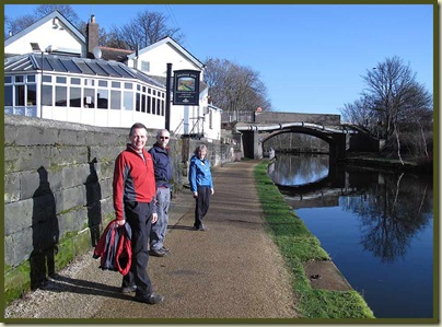
The Bridgewater Canal - outside the Bridge Inn, by Dane Road

[This posting’s images have even less merit as photographic masterpieces than usual, but, as usual, they are intended to complement the narrative rather than be eye-catching in their own right.]

Here’s the River Mersey, which we crossed in Stretford.  You can see from the height of fairly recent debris on the right bank, that the river has been quite full.  What interested us though was the flash of colour as a Kingfisher flew under the bridge to the tree on the right.  Lovely to see these birds near the centre of a major city.  Grey Wagtails, common hereabouts, were also busily seeking their lunch.

The River Mersey at Stretford

The canal is lined by a fair number of trees such as this Silver Birch, sometimes to the detriment of the stone banking and the towpath.

Silver Birch

There’s another pub in the distance – we zoomed on past it – curry was top of our agenda.

The refreshed towpath between Dane Road and Stretford

Some of the canal boats are in rather poor condition.
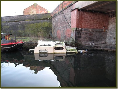
A distressed canal boat

Beyond Stretford, Sustrans are continuing with the repairs to the towpath, which was officially shut hereabouts to protect the new surface and those working on it, but the workmen seemed happy for us to pass.  Hopefully the ugly tarmac will be given a sympathetic covering.

New tarmac in Stretford

We’re still some way from the City Centre, but there’s regeneration of housing around here.
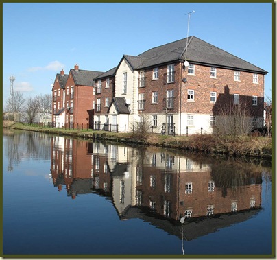
Urban regeneration 
The new tarmac ended where the Bridgewater Canal branched off towards Eccles.  The routes are not signposted here, and the young lady on the mountain bike entertained us by falling off in a quandary at the end of the tarmac.

The Bridgewater Canal heads off towards Eccles

We four layabouts continued along the right hand fork, around the back of Old Trafford football ground, where orchids and water-lilies will soon be flourishing.

Throstles Nest Bridge at St George's

The towpath crosses over Throstle Nest Bridge and heads along a sometimes muddy path towards Deansgate, passing Dukes 92 and the Beetham Tower.

The bar - ‘Dukes 92’ - is so named because it’s next to Lock 92 , which connects the Rochdale Canal with the Bridgewater Canal, and is known as "The Duke's Lock" because the Duke of Bridgewater insisted on having control of the construction and operation of it, so that he could control entry into his canal.

Manchester's tallest building - The Beetham Tower, with Dukes 92

The tunnel under Deansgate used to be longer, but has been reopened at the far end, where you can just see Lock 91, Tunnel Lock.

Deansgate Tunnel

Further on, near the Bridgewater Hall, there’s a small patch of manicured grass with a Duck House.  Very smart!
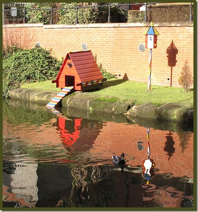
The Manchester and Salford Junction Canal - good for ducks

At Oxford Road we couldn’t seem to progress along the towpath, so we took briefly to Whitworth Street, which is lined by magnificent red-bricked buildings such as Lancaster House.

Lancaster House - Whitworth Street

Looking back, behind the car (below) is the building, now a hotel, that used to be the head office of the Refuge Assurance Company.  I spent many hours in that place back in the days before the electronic age (indeed, before decimalisation), when a whole floor of the building was taken up with ladies using comptometers.

Whitworth Street, Manchester

Rejoining the canal at the Gay Village, we continued to Piccadilly, where an office block, now a hotel, squeezes into the available space above the canal, which is largely underground around here.

It needs a clean!

Central Manchester

To the north of Lock 84 is Dale Street Warehouse, the only stone-built canal warehouse in Manchester. It was built for the Rochdale Canal Company and has four boat holes which allowed boats to unload inside, although the canal arm that led to the warehouse is now infilled and the area used as a car park.
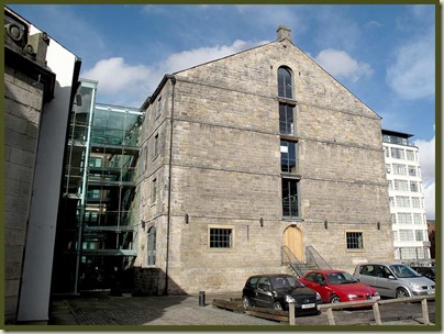
Dale Street Warehouse

There’s much more about this ‘link canal’ here.  And everything you could ever wish to know about all the Pennine Waterways, here.

At this point we left the canal for good.  We were hungry.

As for the Union Bank of Manchester (1836-1940)… we passed by, oblivious of the fact that it became part of Barclays in 1919.

The Union Bank of Manchester

Our destination, and rice and three curries, plus a kebab, for £5.30, was duly attained after some 14km and nearly three hours on the hoof.

This & That, Soap Street, Manchester

It was most welcome, as was the subsequent ale (not taken here, but at some other similar typical city centre hostelry).

Churchills - a typical city centre pub

A fine little excursion.  Thanks, Rick, for the idea and for the invitation.

Our route - 14km, 2.75 hours

More Ale

Later, Sue and I met up with Graham B for a pleasurable 9km evening walk around Marple, punctuated by some very pleasant ale taken at the Hare & Hounds in Chadkirk.

The Hare & Hounds - Chadkirk

Here’s our route, masterfully planned and executed by Graham.
(You missed a good one, Andrew.)

9km with 220 metres ascent - a good two hour stroll

[Can you tell?  I’m running out of steam!]

Au revoir for now.