Sue and Martin in Mallorca 2019

Sue and Martin in Mallorca 2019
On the Archduke's Path in Mallorca

Friday, 6 January 2012

Weather

Sunrise from the Bridgewater Canal near Lymm

It has been a bit grotty recently in the weather department around Timperley, but today I set off in the dark on my bike during a rare dry interlude.

Sunrise from the Bridgewater Canal was really quite attractive.

Sunrise from the Bridgewater Canal near Lymm

Just out of shot is a dredger, clearing silt from the well maintained waterway.

Also just out of shot is my bike, covered in mud.

An inconsiderate thorn then delayed my return home, but at least my hands were warmer pushing the bike than they were riding it.  I hadn’t noticed the frost when I left home, lightly clad.

The purpose of the ride was to test my new lights.  They work fine, but I think the charger may be faulty – surely the battery should not still register ‘full’ after an hour’s use?

Cycling along the towpath was a bit like riding through treacle.  Now I know why I had a five month break from cycling between October and March last year, and a four month break the year before.

Thursday 5 January 2012 – Around Woolston

Gorse (Ulex europaeus) by Manchester Ship Canal
I nipped out yesterday after the wind and rain had passed, for a walk I didn’t think I’d been on before, but it seemed strangely familiar.

I’ve now searched my own blog to find, here, that “a report on the walk that Sue and I enjoyed around Woolston on 18 September (2010)will have to wait, or forever be forgotten.”

Well, until today it was forgotten.  It’s not a particularly inspiring walk anyway, but for the record – and there may be folk local to North Cheshire who may enjoy it – here’s the report on my repeat of the same walk.

It’s just a 15-20 minute drive over the Warburton toll bridge and down the A57 to Weir Lane, on the left just beyond Junction 21 of the M6 motorway.  A stroll down the ever narrower lane leads past a tarted up lock keeper’s house to the River Mersey.  The river used to be the main link between Manchester and the sea, and since the 1700s attempts have been made to adjust its meandering course and make journeys along the river shorter and quicker.  So at the end of the lane is the course of a canal, Woolston New Cut, which has only recently been abandoned and silted up.  Then a bridge took me over the river, which flows due west over a weir (hence ‘Weir Lane’).  This earlier short cut now prevails as the main course of the river. My route took me around a large curve and past a suspension bridge that now merely leads to an uninhabited island due to the shortcut having been dug.

It’s not a good time of year for wild flowers, but there was plenty of Gorse (Ulex europaeus) – pictured above.

The old course of the river leads right next to the embankment of the final solution for navigation to Manchester – the Manchester Ship Canal, dug in the 1890s.  The Mersey feeds into the canal in Salford, but by now has departed again on its parallel journey to the nearby coast.  My route headed alongside the Ship Canal for a while, as far as Latchford Locks, and this view to the west, the bridges in Warrington being either swing bridges or Very High Bridges.  Not many ships venture upstream here nowadays.

Looking down the Ship Canal from Latchford Locks

There’s quite some height in those lock gates – a good 20-30 feet.

Latchford Locks is the scene of much new house building, with just a few terraced cottages remaining from the days when they were probably situated across the road from a factory.

There are playing fields, and pathways strewn with unsightly litter.  The authorities here seem to have given up their losing battle with litter.  Back beside the Mersey, a well protected pipe bridge precedes a near 180 degree bend in the river that leads eventually to Kingsway Bridge, near the centre of Warrington.

Across the bridge, my route took me down the true right bank of the river, with the winter sunshine bathing the scene with unfamiliar light.

The River Mersey at Woolston

I was supposedly following the route of the Mersey Way, a footpath that leads from the east of Warrington for about 35 km to the Mersey Estuary.  Like many things Liverpudlian, this may have been a good idea at the time, with a fair sized budget, but no provision seems to have been for maintenance of the facility.  So nowadays the information boards are blank, the paths are overgrown, signs are missing, benches and picnic tables are rotting, and litter remains uncollected.

However, that hasn’t discouraged the wildlife – perhaps the opposite - there’s lots of it around here, with Woolston Eyes, a major dumping ground near the start of the walk for silt from the Ship Canal, providing artificial marshlands for huge flocks of geese, ducks, waders and gulls.

A family of Tufted Ducks gathered protectively on the river.

Tufted Ducks on the Mersey

After a tricky but avoidable section of path, where recent winds had blown the robust but light and hollow stems of what I assumed had once been Himalayan Balsam across the path, another bend in the river hailed the appearance of the remains of Woolston New Cut, the ‘short cut’ canal mentioned earlier.  My path took me back to Weir Lane via the towpath. 

There’s a bit of water at the western end of the Cut.

Woolston New Cut

Soon an avenue of young trees leads off into the distance, with no sign of any water.  Nor were there many people about.  Despite being near the centre of a large town, I encountered just two dog walkers in over two hours of walking.

The 'towpath' by Woolston New Cut

The water has gone, but the cut has been taken over by several acres of bulrushes as we approach Weir Lane and the end of this short stroll in the sunshine.

Bullrushes in Woolston New Cut

Here’s the route – 12 km with very little ascent, taking 2 to 3 hours.

My route - 12 km with very little ascent in 2.25 hours

There’s a slideshow here, for anyone who wants to learn a little more about this area.

Thursday, 5 January 2012

The TGO Challenge 2012

The outline of Martin and Sue's 2012 TGOC route

Here’s a first glimpse of the route across Scotland, from Ardrishaig to Aberdeen, that Sue and I have plotted for this year’s TGO Challenge.  It was vetted, a few weeks ago, by Alan Hardy, who made some helpful observations as to antiquities we may encounter en route, but no adjustments to the straightforward route were necessary.

It’s quite long, at almost 400 km (250 miles) nearly 50 km longer than we’ve done before, but with only about 11,500 metres of ascent it’s rather less undulating than any of my/our previous crossings.  Some 20 ‘hills’ are included, but some of these are small protuberances that don’t appear on any ‘list’, and just 2 Munros and 1 Corbett are planned.  One of the Munros is Schiehallion, on 17 May, in relation to which I’ve agreed to write a short essay for the Munro Society, who are compiling a 10th Anniversary Anthology of ascents of all the Munros in the period from 1st January to 30th September 2012.  So we’ll be pleased to see anyone up there around 11.30 to 12.30 on 17 May.  Medical Supplies and Shortbread will be available.  You could even leg it over from Alan Sloman’s cheese and wine party a couple of days earlier, but we’ll be setting off from Bunrannoch House at around 8 am.

I’ve still not tidied up the blog postings and photos from last year’s Challenge, but the following images provide a flavour.

Firstly, after walking 30 km up Glen Feshie and over to the Linn of Dee, my companion, ‘Poor Michael’, collapsed in a heap, to be greeted by Judith Barnes, on her way down to Mar Lodge.  “Where are you going?” asked Judith, who then seemed puzzled by my response - “Ballater”, as we headed up Glen Lui towards Derry Lodge!

Judith and 'Poor Michael' in Glen Lui

Cheese and wine features strongly on the Challenge, and the participation of Mr Sloman is not compulsory.  A few days later, at Water of Aven (near Mount Battock) ‘Poor Michael’ and I were joined by Roger Boston, and brother and sister, Markus and Silke – all the way from Austria, for an impromptu gathering in blinding sunshine at ‘Chez Phreerunner’.

Cheese and wine on the TGO Challenge

Happy Days – two of many…

Our 2011 route plan, and links to all my TGO Challenge routes and reports, albeit requiring a bit of editing, can be found here.

Now then, the rain is easing; where shall I go today?

Wednesday, 4 January 2012

2012 – A Gentle Start

Jake - 8 months
Given that the weather has been pretty atrocious, and the forecast was gloomy, Sue and I decided on a rare New Year’s Day lie in, rather than our usual trip to somewhere high.  There seemed little point in using a tank of petrol to get to the top of some hill or other where we would be immersed in view inhibiting clag.

New Year’s Eve saw us lunching together with the pixies (who are now probably too old to appreciate that description) and Kate and Jacob, now eight months.  Those of you who can read upside down may correctly surmise that Jake’s mother is an optimistic mathematician.

The little boy becomes more interesting by the day…

Jake and Kate

Anyway, with mum back at work, he’ll have to fend for himself over the coming months.  I’m sure he’ll manage fine.  There’s a very small slideshow here.

After the NYD lie-in, we did of course observe our tradition of a walk, even if no hills were to be involved, and we were pleased to be joined by JJ for a stroll down the Bridgewater Canal and the disused Warrington and Altrincham Junction Railway as far as Warburton.

We started by lingering on Timperley Bridge whilst JJ finished his breakfast at home.  So this is the first image of 2012.  The first of many!?

New Years Day at Timperley Bridge

This gent appeared to be enjoying his NYD ‘sail’.

On the Bridgewater Canal

JJ duly joined us for the 9km stroll to the Saracens Head, our designated port of call for lunch and the afternoon.

John and Sue on the towpath in Altrincham

We arrived just as the rain started.

Outside the Saracens Head

It rained all afternoon.  We didn’t get wet.  Not externally, anyway. This was a traditional ‘session and sing’ accompanied by Hob Goblin.

Inside the Saracens Head

There were 30 to 40 folk in attendance, many of them, like Richard (below) and JJ, musicians and singers.

Richard Peach - musician

A fair old dent was made in the stocks of Hob Goblin, and there was a moving tribute to JJ’s mum, a stalwart member of this fraternity, who sadly passed away on Christmas Day.

Darkness fell, the rain stopped, the moon came out, and the three of us stumbled back to Timperley without recourse to any other means of illumination. 

It had been an excellent start to the New Year.

Yesterday a stroll into the village for provisions revealed a gaping abyss in the local retail sector.

Greengrocer's shop to let

Ian Moores, greengrocers, was empty, with To Let signs outside.  Whilst it wasn’t the finest of its type, this shop did provide a useful local service.  It’s a sad loss.  The nearby Co-op now needs to up its game.

Luckily, we do still have an ironmongers and ‘DIY’ shop, which apparently opened in 1907.  I wonder how much longer it will survive.  And there’s a bank and an excellent butcher.

The Ironmongers shop survives

Timperley was once the home of John Arnold, a stonemason.  He was landlord of this pub, which dates from 1840.

Stonemasons Arms

It’s also known as ‘The Naked Child’, but that’s another story.

HAPPY NEW YEAR, everyone.

Tuesday, 3 January 2012

John Towers, and Happy Days on the TGO Challenge

FRom R to L: Bernard Fowkes, John Towers, David Towers and Margaret Fowkes, at Inverness railway station on 8 May 2008

2011 ended on the sad note of John Towers’ death on 13 December and his funeral in Giggleswick on 30 December.  It seemed no time at all since Graham and Sue Brookes and I had waved goodbye to him and Janet on 31 October after the annual TGO Challengers’ reunion in Fort William.

John had walked across Scotland 14 times on the TGO Challenge, with his twin brother David who has 21 crossings to his credit .  The ‘Towers Twins’ are pictured above, with John on David’s right, possibly on the first occasion that I encountered them, at Inverness railway station on 8 May 2008.  They are flanked by Bernard and Margaret Fowkes, who this year plan to complete their 20th TGO Challenge, at the ages of 83 and 80 respectively. 

The TGO Challenge is populated by an ageing community, and it’s very sad when members of that community are lost.  John had enjoyed a lifetime of achievements, but what came across at his funeral was a feeling that of all the considerable things he had achieved and enjoyed in his 79 years, the camaraderie and adventure (and indeed ‘Challenge’) of his annual walk across Scotland with his twin brother came very high up the list.

John was given a fine send off.

Andy Howell has written a lovely anecdotal tribute to John, here.  The TGO Challenge message board also has tributes from folk who knew John much better than I did.

Monday, 2 January 2012

Thursday 29 December 2011 – Screaming Cats and extra bits – a bike ride

Mountain bikers in Danebower Quarry

I’ve recently joined the Manchester Mountain Bikers club as a guest rider, principally in order to try some night riding, where for safety reasons it’s probably better to be part of a group.  However, the weather has been so dismal that I’ve not been tempted to desert the comfort of the settee, and anyway many of the night rides are described as ‘fast-paced’ so probably not for me.

However, I noticed this ‘Screaming Cats’ ride and decided to get a bike out for the first time in a month.  It would be Stumpy’s (my ‘new’ bike) first ‘proper’ trip.

Leader Keith advertised the route as “16 miles - usual Screaming Cats route with an extra loop around Knotbury, nice cheeky trail through quarry with a rocky switchback and chute, followed by a techy climb out of quarry, road section around top then fast techy descent to 3 Shires Head . Lunch, then nasty climb, rejoin cats route at top of Cumberland Clough  then last climb and through Macc Forest to pub/cars.”

I’d not heard of the ‘Screaming Cats’ route before, but I don’t think Keith had heard of the ‘Big Macc Ramble’, which I also wrote about here.  Basically, Screaming Cats is a shorter version of the Big Macc Ramble, omitting the descent to Langley and the long ascent to Charity Lane.  But Keith’s extension makes his route a bit longer than the Big Macc Ramble.

The forecast predicted ‘showers at first, clearing by mid morning’ – pretty handy for a mid morning meet, and as five strangers assembled outside the Leather’s Smithy with their bikes the showers had indeed stopped.  But we took so long to get going that the rain decided it had taken a long enough break, so it further delayed us as waterproofs were donned.  They remained in place for the next five hours.

Getting ready to leave from the Leather's Smithy

My usual start from here involves a relaxing descent to Langley and some pleasant tracks in the shadow of Tegg’s Nose before the ascent to Walker Barn and Charity Lane.  Keith’s route was a bit more brutal, and we soon spread out as one by one we felt the effects of our morning coffees and the lack of facilities at the start.

Graham ascends Hacked Way Lane

Despite being strangers, this ride felt like being out with long-standing mates.  There was a bit of waiting around for various reasons, and although I was clearly the slowest rider of the group I didn’t keep the others waiting for long, and everyone seemed more than happy to pause every now and then.

The views across to Shining Tor and the Cat & Fiddle from the top of Charity Lane were not exceptional today (see link to slideshow later) but at least the cloud wasn’t down, it wasn’t raining too hard, and I could educate the others by way of pointing out the highest place in Cheshire (Shining Tor).

Julian and Martin O on  Charity Lane

Continuing along the familiar route to Macclesfield Forest and Bottom-of-the-Oven that ‘Screaming Cats’ shares with the ‘Big Macc Ramble’, Keith provided some useful comments about riding style on steep descents.  I can’t say I’m into technical riding, and I’ve certainly never received any tuition, but this was the first time I’d ridden these loose rocky tracks on a bike with suspension, and I have to confess I found it considerably easier and quicker than with the old Shogun bike.

We were soon on the long road ascent to join the A537 near the Peak View Tea Rooms, from where I hadn’t realised that a good trail leads directly to the Cat & Fiddle, cutting out a hairpin on the busy main road.  Thanks Keith, I won’t be cycling that section of road again.

By now it was somewhat inclement in the weather department, but we unanimously declined the dubious warmth of the draughty interior of the Cat & Fiddle in favour of a blow across Danebower Hollow with the wind vaguely behind us.

“We are all crazy” commented a couple of walkers, hanging onto their hats for dear life as I stopped nearby to collect a mudguard that had been expelled from the bike by an unexpected gust of wind.

“Do you want to do the 5-6 mile extension, or continue around the 12 mile Screaming Cats route?” asked Keith.  If there were any dissenters, they kept quiet.  I was firm with my choice – the extension was what I’d really come for.  Everyone seemed happy enough despite the increasing frequency and intensity of the showers, and we were soon enjoying a technical descent into Danebower Quarries.  I walked – I didn’t want to damage myself on this first trip with the club.  The slideshow has some images and videos of the quarry descent and ford (which all bar Martin O walked across).

Then we headed along an excellent path above Knotbury, taking an unexpected turn left up the hill to the pub and cafĂ© at Flash Bar.  I was lagging behind and thought that Keith had taken pity on Martin O (soaking wet and cold) and brought us slightly off route to the warmth of the cafĂ©.  But no!  “Oops!” exclaimed our leader, and headed off back down the hill without another word.  Having regained the planned route, another enjoyable descent brought us to our designated lunch stop – Three Shires Head.  Martin O paced up and down in a futile effort to get warm – he eventually snatched my camera and took some nice pictures of the water, the best of which is the lower of those below.  Meanwhile, here’s Keith, like the rest of us, chomping through a butty.

Keith lunches at Three Shires Head

Three Shires Head (photo taken by Martin O'Mahony

Whilst I took a few images on the ascent from Three Shires Head – nobody managed this tough climb over loose rocks without having to dismount – the weather closed in for the rest of the ride and the camera was moved to a more waterproof location.  The descent to Cumberland Cottage and the road at Clough House was so much easier with suspension – a totally different experience from the one I’m used to – but it did take us rather a long time.  That was thanks to a problem with Graham’s brakes that Keith eventually fixed, but not before Julian and Martin O had spent much of the 40 minute delay cowering behind a dry stone wall in an attempt to shield themselves from the sheeting rain, sleet and hail.  The conditions were less than pleasant.

The ‘usual’ route through Macc Forest was eschewed in a bid to get back to the cars before dark, and whilst a very slow vehicle did its best to foil us on the tarmac descent, we did all succeed in that objective.

The Leather’s Smithy was full of people, but its doors were locked, so with several riders wanting their hot baths as quickly as possible, we gave the pub a miss, heading off home but leaving Martin O sitting in his car in an attempt to thaw out.  Perhaps he’s still there!

There’s a 24 image slideshow here.  Note that the video captions may be out of sync, due to a problem with Picasa.

Here’s our route - approx 28km (18 miles) with 700 metres ascent in about 3 hours riding time, taking us a very leisurely nearly 5 hours in total.

Our route - approx 28km (18 miles) with 700 metres ascent in about 3 hours riding time

Here’s the ‘report’ from my Garmin gadget:

Thanks for your company, everyone.  I really enjoyed this first trip out with the MMB club.

Wednesday, 28 December 2011

Tuesday 20 December 2011 – An Evening Stroll up Shutlingsloe

Sue, Dave and Toby on Shutlingsloe's summit

OK, I’m a bit behind.  But I’ve tried to be sociable over Christmas, so with house guests for five days this blog posting has taken a back seat.  And son Mike’s continuing efforts to decorate his house have drawn a little help from me, probably just wanting to appear to be useful.  I have also to apologise to him for dragging him out on his first run, let alone Parkrun, on Christmas Eve.  “They were laughing at me running in jeans” he commented about the marshals, “and I got fed up of being overtaken by Father Christmas’s.”

“I’m going to adjust my pace next Saturday” he added, having realised that doing the first of the five kilometres in 4 mins 30 seconds probably wasn’t the most sensible pace to start your first ever run.

Anyway, I’ve already mentioned last year’s version of this walk up Shutlingsloe (here), and the year before (here), and the year before that even got a proper report! as did the year before that – here – in the early days of this blog. 

This year Colin, fairly fresh to blogging, quickly wrote about this year’s potter up Shutlingsloe (here), which only took place as a result of a petition from big Andrew (aka Notchy).  So, with kind permission from Colin, and just a smidge of editing, here’s what he thought of it.

“There’s always first time for everything. Last night it was one of Martin and Sue’s evening walks. Martin has said in the past that sometimes it will only be about 3 people. Well last night it was 17.
I think Martin ran out of fingers to count us in the dark and with everyone bobbing about in the car park. Head touches beamed in to your eyes. I am sure he had to do a few recounts.
(Ed: yes, Colin, arriving late didn’t help our cause, and I was dazzled by both the sudden popularity of this annual event following the protest after it was deleted from our programme, and by all the Petzls shining in my face.)

Anyway we all set off on easy paths up onto Shutlingsloe above Macclesfield. At 506m (1660ft) it’s a steep sided hill and sometimes described as the Matterhorn of Cheshire. It is the third highest peak.

The weather was damp with low cloud. On reaching the top Martin bound up onto the Twig (sic) point for his photo in the cloud before leaping back down to his rucksack.

Martin on Shutlingsloe trig point

From where he produced Fudge and Fudge Brownies, and hot mint tea.  And a box of Rocky Roads appeared from Diana’s bag.  We wouldn’t go hungry or thirsty!  After much appropriate jollity, JJ then gathered everyone around, for us to blast out the We Wish You a Merry Christmas song.

Brownie Any One?

Sue offers brownies

Fudge anyone?

Martin offers fudge

After quite some time on the top, it wasn’t just the children who were getting cold, so it was time to head back down to the car park where those with children went home and the rest of us gathered in the Leather’s Smithy down the road. Where I must say the light Christmas ale was very nice.

Very Nice.

Excellent 2hour, 5km walk.” 

Thank you Colin, for these words and pictures.

Saturday, 24 December 2011

Happy Christmas!

The Bridgewater Canal, Cheshire, on 20 December 2010

Wishing all our readers a very Happy Christmas.

Just in case anyone has a desire to follow a summary of what we’ve been up to this year, we’ve written a short piece, mainly for family, here.

Have a Good One….

Wednesday, 21 December 2011

Tuesday 13 December 2011 – The Lancashire Trail (Part 3) – Coppull Moor to Horwich

Norman suddenly realises that he is next to Hic-Bibi Brook 
"There will be mud" promised Reg, as we set off east from Coppull along an asphalt track.

Seven old codgers had successfully rendezvoused more or less where we left off on 9 November, despite nearly abandoning Don in the gents at Wigan Bus Station!

R Norman, who at the tender age of 59 is still too young to be a fully paid up ‘Plodder’ took up his usual position as ‘Font of all Knowledge’.  “Shouldn’t that be Fount of all Knowledge” – quipped some wag.  Sharp as ever, Norman’s response was clear:

“Font and fount can both be used in that phrase” he explained…
”font had, and has, another life related ecumenical matters, as in ‘baptismal font’, and was taken over from the Latin use of fons, fountain, whereas fount came to English through the Old French font, derived from the same Latin word. I can’t explain the vowel change!”

Well, we were shocked.  None of us had previously experienced Norman failing to explain something!

Anyway, I digress, we need to move on to explain the header picture – over to you, Norman…

"This is 'Hic-Bibi Brook'" he spluttered "one of very few rivers that runs inland from its source." "What?" chorused the audience.

"Hic Bibi - it's a spring as well; Oliver Cromwell refreshed himself here when advancing south after the battle of Preston in 1648. A stone inscribed "Hic Bibi" ("Here I Drank") marks the site” he expounded.

”Look, there’s the plaque placed there by old Oliver in 1648.”

Hic Bibi ('Here I drank' - Oliver Cromwell)

“The spring was turned into Seven Stars Brook to feed Wigan Corporation water supply” muttered Reg, “and that plaque has weathered well, hasn’t it Norman?”.

[There are more details in Reg’s report, here]

That quietened our ‘font’, and we pottered casually across some Lancashire fields, heading east, in search of mud.

Suddenly Norman spotted something and dashed off.  (See picture below) “It’s a squirrel” we expected him to inform us.  But no, his waggly arm was suffering from limpitude.  He really meant to point out the bridge, just above his right hand, through which a mineral line used to carry coal tubs, as well as produce from the Hic-Bibi brick works, to the main railway.

Man with 'sticky-out arms'

The gathered crowd listened in amazement as Norman told us about the long history of Coppull

“There was even a pub called The Railway Hotel” droned Norman “where the landlord’s son was a qualified dentist and teeth were extracted on the premises, a glass of port being included in the charge.”

All this talk, especially the references to pubs, had engendered a great thirst, resulting in one of our number, on spotting the Crown, rushing ahead and insisting on sustenance, before being dragged out by his leader.
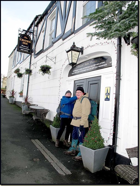
 Reg drags Norman out of the pub (it's 11am)

We came upon some reservoirs, Worthington Lakes, constructed in the 1890’s to provide water for the print works and other local industries, on this typically December day - dull, with brighter interludes.  One such interlude was chosen for elevenses in the sun.  Norman got the bench as all that talking had made him feel a little geriatric. That didn't stop him from guzzling fudge brownies!

 Elevenses by reservoirs

Luckily, we found a bridge to cross the raging River Douglas.

 Crossing the River Douglas near Arley Hall

We paused outside the fine old Manor House that accommodates Wigan Golf Club. The 12th century moat used to be home to black swans, but now only white mute swans harvest the weed.  Tales were told by Reg and Norman of how ferocious guardians of the Golf Club usually shoo away walkers curious about the history of the building, Arley Hall, but today nobody spotted the small group of pensioners pausing in admiration before the front door of the golfing sanctuary.

It was ladies day.

 Mute Swan in the moat of Wigan Golf Club's manor house HQ

We soon crossed the Leeds & Liverpool Canal, with a familiar view to East Lancs LDWA members, on our way to Little Scotland.

Reg's walks traditionally include moments of indecision, especially when the back of R Norman's hand isn't in sight.

 "Are we lost again, Reg?"

The uncertainty resolved, we pressed on in our relentless search for mud, passing through Blackrod village, which has a long history and is home to some lovely stone cottages.

A huge stallion blocked our way, and this chap who appeared to have been enjoying rolling in something.  Could that be mud?

 Path erosion machine

Yes, of course.  Reg sighed with relief as his promise came true and the muddy water gurgled through the fabric of his trail shoes.

 Lancashire mud

After crossing the M61, we came to a quite substantial brook, the infant River Douglas, that emanates from the reservoir at Rivington.

The weather had reverted to ‘Dull December’ as we paused to ponder the view towards Rivington Pike and the masts atop Winter Hill.
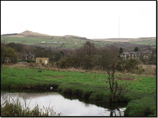
 Rivington Pike and Winter Hill

Our morning’s exercise concluded along a stretch of path that was recently obliterated by a new housing development.  This didn’t go down well in some quarters.  Action was taken.  Norman was involved.  The right of way has been reinstated...

...at the expense of someone's garden.

 Reinstated right of way through a garden
The walk finished at SD 631 120, on the outskirts of Horwich, where the resident wallabies were reluctant to venture out of their warm house to pose for seven strangers.  So five of us adjourned to Reg’s house whilst Jim and Bernard shot off to deal with pressing commitments. 

The meal provided by Reg’s wife, Saro, was exceptional – a fine way to conclude the season’s ‘Plods’ – thank you very much.

Here's today's route, just 10km with about 150 metres ascent in 3 hours, followed by that excellent lunch at Reg's house. Brilliant!

Our 'Part 3@ route - 10km, 150m ascent, 3 hours

We will reconvene for stage 4 on Wednesday 18 January – Reg will be sending out more precise details in the New Year.

Reg’s more accurate report on this walk, with some more historical titbits, is on this web page, and my 32 photos are here.

The excursion took place over a week ago, and apart from Saro’s meal my recollection of it is a bit hazy.  I hope I haven’t slandered anyone!

Back to Lancashire Trail Index