Sue and Martin in Mallorca 2019

Sue and Martin in Mallorca 2019
On the Archduke's Path in Mallorca

Saturday 21 September 2019

Pyrenees HRP - 2004 - Day 29

 
Sue and Martin's Big Adventure
 
Day 29 - Monday 23 August 2004 - Stage 23 (continued)

Postcard Summary 
Attentive hotel to Luchon
Woodland walk, then campsite & stocking up chores, plus halftime celebrations – 2.75 hours, 14 km, 200m ascent
A short day at last.  Whilst Julie took the bus, we enjoyed a lovely walk on old lanes and footpaths to Luchon, where the path arrived in one of the backstreets!  Lunch in the park, then clothes were washed before the afternoon storms started.  Strolled along the main street later, stopping for a beer and deciding to have a rest day tomorrow (a whole one!) to celebrate being half way across!  So the ‘stocking up chores’ were considered but not actually executed – the next stage is quite tough and remote, and the weather has taken a turn for the worse.
 
 
Diary Entry (by Martin)
Nice breakfast at the attentive Hotel des Spigeoles in Oô.

Julie elects to bus it to Luchon and the hotel owner helps to guide her to the 9.40 minibus, on which she is the only passenger for the picturesque half hour journey.
 
Meanwhile, Sue and I set off along a pleasant contouring footpath in the direction of Luchon. Path number 78 seemed to take the right direction, though we left and re-joined it a couple of times. 
 
 
It was cloudy but warm, and very pleasant strolling along shady mossy lanes with relatively light loads.
 
Hardly anybody about - a couple of mountain bikers, and a few other people as we entered Luchon. It got quite sweaty as we rose steeply through a field for 50 metres.
 
Having left Oô at 9.15, we first sighted Luchon, bathed in thin sunshine through gathering cloud, at 10.30. But it took until 12 noon to finally drop steeply down to the town and rendezvous with Julie outside Tourist Information. Lots of mountain bike route signposts on the way - there are some good routes from Superbagnères (1800 metres), reached by gondola. Luchon even has sturdy, elaborate, scooters for hire to daredevil descenders.
 
 
After some unexpected 'ups' and some severe 'downs', Luchon was gained - a busy town - the largest by far that we will pass through. We bought the usual nice lunch - baguette, goats cheese, tomatoes, pâté, fruit, drinks, etc and enjoyed it on a park bench by a duck pond before adjourning to Camping Des Thermes, where Julie had found a camping spot next to a noisy works. And then we had a rest / planning afternoon and eventually decided to stay here another night. Effectively a 'half term holiday', as we are almost exactly that in both time and distance.
 
The weather deteriorated, with a couple of thunderstorms, before we adjourned for a third walk into Luchon (fourth for Julie) for a nice meal at Caprices d'Efigny restaurant, with some Olympic athletes in the background at an earlier bar, but no sign of any Brits!
 
Stats and route (Viewranger):
14 km, 350 metres ascent, 2.75 hours


Friday 20 September 2019

On the South West Coast Path (3) Polperro

 
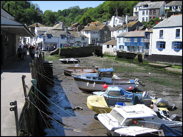
We passed through Polperro, one of the 'beauty spots' of the Cornish coastline, on 29 May 2005.
 
Whilst I remember it well, I don't have the relevant volume of my diary to hand as it's in the guest bedroom that's occupied by Ken and Helen, our visitors from Canada.
 
So I hope these four pictures might rekindle some other fond memories.
 
I think the bird is a herring gull, and I don't recall it snaffling any of our lunches - but the diary may prove me wrong...


Thursday 19 September 2019

Pyrenees HRP - 2004 - Day 28

Ascending to Col des Gourgs-Blancs
 
Sue and Martin's Big Adventure
 
Day 28 - Sunday 22 August 2004 - Stage 23

Postcard Summary
Green lake to Oô (a village)

Excellent alpine day with glacier, boulders and 2000m descent – 11.25 hours, 18 km, 800m ascent
As our camp was already up at 2400 metres, there wasn’t too much height to gain but the ground was either boulders, steep scree or glacier.  Good plod up hard snow in early sunshine.  Super views of surrounding mountains.  Rose to another col before descending for a sunny lunch near Refuge du Portillon. During the afternoon the path dropped relentlessly into a green, lake-filled valley with waterfalls, a lovely contrast to the morning’s alpine scenery.  Julie hitched the last 4 km whilst we used a path to reach the village of .  As the campsite no longer existed, it was a hotel for the night, and a welcome shower.  A long day, but a good one, and some well-deserved beers in the evening. 


Diary Entry (by Sue)
A magnificent, if long, day in alpine landscapes with beautiful weather. It was a cool, but clear morning at our green (from glacier melt) lake, and we were away at 8.15 am, on a rocky path to Lac du Milieu.
 
It became more bouldery, then climbed steeply up a scree slope. From the top, our objective was visible - the Col des Gourgs Blancs, at the top of a glacier. The glacier wasn't steep, but as it was early, the snow was quite hard. It was a long plod up, reaching the col at 10.15 am (2877 metres), where we lingered only long enough for a photo, as the wind was cold.  
 
 Ascending the Glacier des Gourgs-Blanc
 
 
Col des Gourgs-Blanc
 
The steep rocky descent, we stopped for a mountain mix / chocolate break, trying to work out which way to go to the next col. Now, there were quite a few folk around, some with ice axes for the snowfields. From here, the view is rock and snow.
 
Col du Pluviomètre was easy to aim for, as the large rain gauge stood out well. We took Georges Véron's advice and went up the rock spur to the south. More snow, boulders and rock, and it was reached at 11.30. Excellent views from here, back to Pic Goudon and Pic des Spijeoles, right off the first col, down to Lac Glacé and Lac du Portillon, and across to Pic de Perdiguère.
 
Pic Perdiguère from Col de Pluviomètre
 
 Lac Glace
The descent to Lac du Portillon was hard going, on boulders following cairns, in parts contouring around the hillside. A nice lunch stop just above the Refuge du Portillon, the three day old bread being quite acceptable.
 
Below Lac du Portillon
 
 Trumpet Gentians
Here, we leave the HRP, for a resupply in Luchon, so it is the start of a huge descent for the afternoon. The path improves, the air warms, and a view of a green valley with three lakes emerges, after the starkness of the morning's terrain. The path was wide, well constructed and busy. It descended gradually to Lac d'Espingo, an area with sheep grazing and people admiring beautiful views.
 
 Views to Lac Saussat and Lac d'Espingo
 
 Taking a break near Lac d'Espingo
 
 
 Refuge d'Espingo
From here, a steeper descent plus the aid of zigzags through trees to the lovely Lac d'Oô ', a large lake with precipitous walls, and a long waterfall cascading into it. The Auberge supplied cokes, and we waited for Julie, whose knees were suffering from the long descent.
 
 Lac d'Oô
Unfortunately, on leaving there at 5.30, we still had a few miles to go to reach the village of , where Martin's (old) map showed a campsite, but Julie's (newer) map didn't. The path widened to a track, and there was soft green evening light on the hills.
 
 Julie outside the auberge at Lac d'Oô
At the car park, Julie stopped to hitch. We ate some mountain mix to fend off the hypoglyccaemia both had felt, then continued on a gently descending path/track.
 
Oô was lovely - old cottages, a boules area, river running through, and whilst we were taking all this in, a car tooted its horn - it was Julie in the back of the hotel owner's car. She had successfully got a lift from the second or third car past, but the campsite no longer existed when she got to Oô. So we were all booked into the Hotel Spigeoles, a family-run place. The hotel owner had spotted us marching past, and had gone to ask Julie if it was us. The lift was offered when Julie panicked as she had no shoes on!
 
 Hotel Spigeoles
By now it was 7.15 pm, and we were ecstatic. There was even a double bed! In no time, we were all showered and downstairs in the dining-room enjoying a cold beer. The set dinner was cold meat and salad, then lamb with lots of potatoes, then cheese and ice cream. It was a well earned one. The sky was still clear, as it had been all day, when we turned in after 10:30.
 
Stats and route (Viewranger):
21 km, 1700 metres ascent, 9.5 hours


Wednesday 18 September 2019

On the South West Coast Path (2)


Here's a picture taken on our 2005 trip to the SWCP. Most of that route was undertaken in May - over a period of years - during which the cliff top meadows are laden with Thrift (Armeria maritima).

A delight to behold.

Tuesday 17 September 2019

Pyrenees HRP - 2004 - Day 27

 
Sue and Martin's Big Adventure
 
Day 27 - Saturday 21 August 2004 - Stage 22

Postcard Summary
Barking dog camp to Lac des Isclots
Back to a typical day in beautiful but cool weather – 9.5 hours, 18 km, 1500m ascent
An early start from camp, where our alarms were pre-empted by the barking dogs, then a long, cool haul up to a high pass, down for a nice lunch, then around a high and exposed (but wide) contouring path.  Eventually arrived at Lac de Caillaoues, before the final ascent to a beautiful spot by the lower Lac Des Isclots to camp. A lovely evening.


Diary Entry (by Martin)
Luxuriating in the tent at Lac Des Isclots - 2398 metres - in late sunshine with wisps of cloud blowing across the lake, a full stomach and plenty to drink. What could be better!
 
Today was a typical HRP day - woke soon after 6 am to the sound of barking dogs (not typical) and dozed until the second alarm at 7 am. A poor breakfast - an error not to buy muesli - fruit and fibre cereal is a poor substitute, especially with only water to wash it down.
 
Still, it was a nice day, if cold, and we set off in fleeces and long trousers (except Julie) at 8.10. 8°C. Lots of geological interest ahead to the east, with crumpled rock strata in evidence (the Posets?). We soon passed the Viados hut (8.30), and I stopped to change into shorts and t-shirt at 9 am, at 1800 metres, to avoid overheating, then felt cool - it was only 7°C.
 
Eventually by 10 am, we had reached the junction of three streams, where GR11 heads off east to Estos, and we head north. We moved back into the sun here, after being in the shade - 2010 metres, 11°C. Very pleasant. So we headed up, as directed by our two guidebooks, to Port d'Aygues-Tortes (2669 metres).
 
View from Port d'Aygues-Tortes
 
 
Despite it being a Saturday, we saw very few people today, especially on the Spanish side (before the Port). Two people dashed past us descending into Spain, and a couple were lunching at the high tarn. Big views from the col - 12.10. Then we descended directly and easily, following cairns, to the Aygues Tortes valley, for a pleasant lunch from 1.00 to 1.50, amongst a carpet of bright yellow Dwarf Eyebright flowers.
 
Lunch below Port d'Aygues-Tortes
 
We ate well today - the usual two tins of various fish (roe, and mackerel in mustard sauce today) on a baguette, skilfully carried by Sue, with copious 'mountain mix' and chocolate.
 
After lunch we descended to about 2050 metres, then headed up a well marked path to Pouchergues before in an easy track around Pic de Quartau, high above the Clarabide valley and the huge power station at La Soula.
 
 
It suddenly warmed up along this path, after being a really cold day until then. Cloud invaded our views from the French side, and the mountains were shrouded in it for a few hours, before, by now (8.15 pm) clearing completely, leaving a wide open view with a little high cloud and a crescent moon visible from our tent door.
 
We progressed around the track, exposed at times, with the occasional bit of railway line, and some metal walkways. At one point we even seemed to pass through a house. Eventually we reached the main path from La Soula and followed it up to Lac Caillauas, a large reservoir, eerie in the mist. Julie caught up by going across the dam (Sue and I missed the path). An interesting rocky route in the mist then took us up to the lower Lac Des Isclots ('lake of little islands') by 5.35 (Julie a bit later). 2398 metres, 18°C, 768mb.


Others were camping, but we found a good spot and had a relaxing few hours and a good meal before ordering hot chocolate from Julie (now 8.30) once our diaries had been updated.
 
Camp at Lac des Isclots (2400 metres)
 
Julie's feet are feeling a bit (very sore earlier) better - it was a hard day for her but she did (just about) keep up! (After a reassessment of her luggage in Bielsa.)*
 
* I was wondering whether there would be reference to this. Upset at finding my Phreerunner tent relegated to the outside of Julie's rucksack, I had insisted that she dispose of sufficient items to enable the tent to travel inside her rucksack. Thus several pots and pans and other unnecessary equipment had been binned in Bielsa... - Ed
 
Stats and route (Viewranger):
18 km, 1500 metres ascent, 9.5 hours