Sue and Martin in Mallorca 2019

Sue and Martin in Mallorca 2019
On the Archduke's Path in Mallorca

Friday, 14 October 2011

Saturday 8 October 2011 – A Jog in the Park

Jake


“I’m doing a ‘Park Run’ on Saturday” announced Kate.  “Why don’t you come along, and Sue can look after Jake and Oscar.”

What Kate says goes, so I got the bar code that you need in order to participate in these 5km runs that are held all over the UK and beyond at 9am on Saturday mornings, and off we went.

The Oldham run is three and a half laps of an undulating circuit in Alexandra Park. 

Oscar kept a look out for his boss…

Oscar

…as she trundled past.

Kate

I didn’t really dress for the occasion - “Have you got some running kit under there?” questioned the Master of Ceremonies – a man from a shop called Sweatshop.  That didn’t bother me.  “I’m not a runner”, I admitted.

Martin

The jog did provide a voucher from Sweatshop and some good exercise, and the threat of being lapped by her dad did stimulate Kate into knocking a few minutes off her best time.  I think I’ll go again tomorrow, it was really rather fun.

Feel free to join in.

I’ll use this posting to insert further photos and results statistics in due course. 

Chopin in Manchester

Chopin - Deansgate, Manchester 
I couldn’t help but notice this rather fine statue near the junction of Brazennose Street and Deansgate last Friday, when I was pottering along on my way to lunch at the Old Grapes with a former colleague.

 Fryderyk Chopin

I though it was rather jolly.  Well done, those responsible.

Chopin - detail from the Deansgate sculpture

This link gives a fuller story – the statue was apparently unveiled on 16 September 2011.  Here’s an excerpt from a news bulletin at the time:

The 2.5 metre wide statue, a stylised bronze of the composer seated at the piano, was created by Polish sculptor, Robert Sobocinski. The bronze – the largest statue of Chopin outside Poland includes material dating from 1831, the year of the November Uprising by Poles against the Russian Empire.

“We are very proud to see this striking monument to one of Poland’s greatest sons here in the heart of one of Britain’s greatest cities, which has been home to many Poles over the years,” said Andrzej  Person, Chairman of the Polish Senate Committee for Migration and Polish Diaspora Abroad.

Thursday, 13 October 2011

Thursday 6 October 2011 – The Salford Trail (Part 5) – a reprise

Marge and Steel

Today I was due to meet Reg and other East Lancs LDWA ‘Plodders’ for a reprise of the walk that we originally did on 21 July.

I travelled uneventfully by tram to Eccles, where Morrisons enabled supplies to be taken on for the rest of the day.  The number 67 bus then took me to the outskirts of Cadishead, where it suddenly shot off into a housing estate and terminated by a patch of grassland I recognised from Part 4 (SJ 703 018).  It was nearly 11 o’ clock, and as the LDWA always set off on time I jogged down to Glaze Brook and the ‘Marge and Steel’ roundabout (see above picture).

The sun was shining, but nobody was to be seen, and there were no cars in the lay-by, so I set off.  Cadishead Way is a long straight road.  There was no sign of anyone, so I went back to the roundabout.  Still no cars in the lay-by, and no sign of anyone.  I scrutinised the Marge and Steel plaque.

Marge and Steel - the plaque

11.15.  Set off again – I thought they must be way ahead by now, so I managed a fair pace.

The disused bridge over the ship canal was soon passed – the line continues in a remarkably short distance through Partington/Carrington to reach Timperley near Sinderland Brook and cross the Bridgewater Canal near our house.

Disused railway bridge over the Manchester Ship Canal

I wrote about this renovated Soap Works shunting engine in my previous report.

An old Soap Works shunting engine

The lush vegetation we saw in July has died back a bit, and the flowers have been replaced by berries.

Not so many flowers as in July

By the time I reached the Boat House the sun had gone in and it was drizzling.  There was no sign of Reg and his men, so I continued in pursuit.

The Boat House

After lunch beside the Ship Canal, the path beside the canal drew me towards the new City of Salford rugby stadium.  I wondered what it must have been like to stand in this spot a hundred years ago.

First sight of the City of Salford Stadium

The building work looks as if it’s progressing well.  The turf has been laid and there are some (practice/five-a-side?) pitches with synthetic surfaces beside the main stadium.

Stadium nearing completion?

On reaching the Bridgewater Canal I gave up my pursuit and decided to walk along the towpath to Stretford, rather than go to Salford Quays.  I found the view from the swing bridge over the Ship Canal quite impressive.

The Manchester Ship Canal and the M60 Motorway

The Bridgewater Canal flows happily over the Ship Canal.

The Bridgewater Canal crosses the Ship Canal

The Bridgewater Way is ‘work in progress’, but already some of the informative signs have been abused.

Graffiti

Approaching Stretford, I came across an impressive series of bridges.  The distant bridge is a footbridge over the Bridgewater Canal, where a spur to the right provides a link with the Rochdale Canal; then there are bridges for a disused railway line, the main Manchester to Warrington railway line, a footbridge near Trafford Park station, and a pipe, perhaps carrying water from the Lake District.

Canal Bridges

From here, a short stroll to Stretford found me a tram, and I was home by early afternoon.

Here’s my route – 17km in a bit more than 3 hours, with minimal ascent:

Meanwhile, Reg reported:

“Six Plodders braved the storms of yesterday to walk the 5th section of the Salford Trail.  Sheltered in the Ferryboat Inn (sic – it was the Boat House) for a while. The landlady felt sorry for us and let us eat our sandwiches in the pub while we sampled some of her excellent chips and coffee.  Further adventures involved scrumping apples and a tram ride from Media City.”

I was baffled…
…until I discovered that they had met at another lay-by 400 metres back along the road, and they had set off at 11.10, so I must have been just out of sight when they got to Cadishead Way.  I’d been ahead of them all the time.  And ahead of the ‘storms’ to which Reg refers!

The previous report on this walk is here, and an updated slideshow is here.

The walk had been specially arranged for one ‘R Norman’, an LDWA stalwart, who had called off at the last minute.  So there will be a third attempt at this route for his benefit.  I may be there – perhaps I’ll just sit in the Boat House Inn and wait, as R Norman is known to be incapable of walking past a pub.

Tuesday, 11 October 2011

Wednesday 5 October 2011 – A Curry Walk

“Fancy a Curry Walk?” asked JJ.

JJ on the Bridgewater Canal towpath in Timperley

I think that was a “Yes”.

We met on the towpath in Timperley at 10am, for a re-run of the walk we enjoyed on 16 February 2011.

After passing posh barges in Sale, Stretford’s water borne transport looked a little run down.

The Bridgewater Canal at Stretford

John’s brother Damian met us in Stretford.  He’s over here from Sydney, on his third visit in twenty years.  Here they are at the junction where the Bridgewater Canal heads off towards Eccles and our route to Manchester is beside the link with the Rochdale Canal.

John and Damian

Earlier in the year, orchids and water lilies flourish here, but today the colour in the hedgerow was provided mainly by Asters.

Aster, or Michaelmas Daisy?

The Australian tourist seemed fascinated.

Canalside sign

Beyond the football ground, the towpath changes to the other side of the canal, at the Throstle Nest Bridge in Old Trafford.

Throstle Nest Bridge - Old Trafford

There’s a Throstles Nest pub nearby.  It used to be my ‘local’.

Here’s the view towards Manchester from the bridge.

View towards Manchester from Throstle Nest Bridge

Nearer to ‘town’ I took a close-up picture of this freshly painted bridge, but have chosen the following image in preference, illustrating not only the finely decorated bridge, but its exhausted painter, an exercising office worker, a camera happy Australian tourist, a thirsty TGO Challenger, and some very old cobbles.

A newly painted bridge

Castlefield, backed by the Beetham Tower, always seems busy with boats, bridges, waterways and people.  It’s a vibrant spot that just a few years ago would have had the air of a desolate wasteland.

That’s Rick, on the bridge, passing the time with a local eccentric whilst waiting for us.  He would never miss a curry opportunity, even when not fit enough to complete the walk.

Castlefield

The area sports numerous ‘touches’ in support of city centre wildlife, here by way of inaccessible bird boxes under a very old railway bridge.

Birdboxes in Castlefield

After walking through Manchester’s centre, almost entirely beside the canal, our objective - ‘Rice + 3 Curries - £4.90’ - was finally reached.

This & That

15km in just over three hours. After lunch we adjourned to the ‘English Lounge’ for a beer.  Unfortunately there was no beer, so we went to the Shakespeare, where the Boddies was on tap but ‘off’ if you get my drift.  The Spitfire went down well, though!

Here’s the route:

Saturday, 8 October 2011

Monday 3 October 2011 – A Breath of Fresh Air

The Lune Estuary and Plover Scar Lighthouse

The first working day in October is the anniversary of my giving up full time work.  3 October 2011 is the eighth anniversary.  Curious, then, that I shall be breaking off writing this posting (Friday morning) to visit the office and enjoy lunch with an old team mate, who despite being the same age as me continues with the daily ’grind’ (albeit on a part-time basis).  Unlike Sue, who this week went back to work full time for six months!

Coincidentally, 1 October was the fourth anniversary of this blog, which I still enjoy compiling, but I’ve felt no urgency to record this week’s wanderings, (this morning has been spent catching up with other blogs on ‘Google Reader’ – apologies for the paucity of comments, time is the enemy as always), and I don’t feel compelled to quote any statistics, gear review policies, political statements, or anything much else (just now) outside the usual ‘what we got up to this week’ sort of postings.

On my first ‘day off’ when I went part time all those years ago I chose the Snowdon Horseshoe for a day out, and ever since then I’ve tried to celebrate by doing something active and interesting:

Year 0: Snowdon Horseshoe
Year 1: The ‘Missing Link’ trip to Cornwall
Year 2: Snowdon Horseshoe
Year 3: Half Dome
Year 4: The Altrincham Circular (my first blog posting)
Year 5: Eccles Pike (a bit short, that one!)
Year 7: South West Coast Path, and a Half Marathon
Year 8: Trips to the Southern Uplands, and Shropshire

This year I wasn’t in the middle of any ‘trip’.  It was Sue’s first day back at work, so it would be unfair for me not to be home in time to cook tea, and the cloud was going to be down over both the Lakes and Snowdonia.

So a day out in the Peak District was in order…

Think again.  I’d had my eye on Norman Thomas’s  ‘A Breath of Fresh Air’ walk for a while.  It’s not far from home to the starting point at Conder Green, and at 35km (22 miles) it’s a good distance for a brisk walk on an autumn day.  Anquet mapping on my computer told me that it reached the dizzying maximum height of 35 metres, so barring a bout of sea fret I’d have a cloud free day out.

So I enjoyed a lie in and was further delayed by someone crashing into the back of my car* at the traffic lights in Galgate, before reaching the car park at Conder Green at 9.30.

The walk is described on the Breath of Fresh Air website, and has been waymarked, so it’s easy to follow.  But the text on the website is currently ‘out of order’ with the description from Lancaster to Conder Green having been inserted immediately after Cockerham.  So I’ve copied and pasted it in the correct order in blue italics below – I hope nobody minds, and that also saves me some writing…. though I’ve added my own observations and map as well as the website’s map.  I’m sure the publicity of this excellent walk will be appreciated anyway.

Would you believe that during the course of the walk I took over 200 photos!  My Canon Ixus 105 is sadly far inferior to the broken G10, so most of them truly reflect the standard of my snapping – very average.  But they do provide a pictorial essay by way of a Picasa slide show (123 images) – click here.

To arrive at the start, go past the front of the Stork Inn in Conder Green, down the narrow lane to the car park (free parking).  This is the site of Conder Green station, opened in 1883 by the London & North West Railway Company on its line from Lancaster to Glasson Dock.  The station closed in 1930, but freight traffic continued to ply the single track line until 1964.

From Conder Green car park entrance, by the cafe – the CafĂ© d’Lune, closed from 31 October, closed on this morning at 9.30 - follow the coastal path over the river to Glasson Dock. Turn left at Lancashire Coastal Way (LCW) finger post, right past the public conveniences and left again at the Victoria Inn to cross over the road.
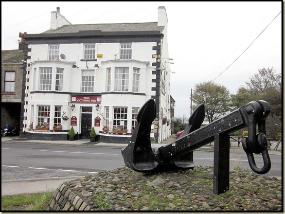
The anchor, outside the Victoria Inn

Go past the large anchor and cross the bridge over the dock entrance and turn right at the cafe. Go left through The Dalton Arms car park and at the far end turn right and then immediately left at the anchor to go up Bodie Hill.

Continue left onto the main road, joining it by an orientation point in memory of local historian John Hayhurst OBE.  Helvellyn is noted as being 36.5 miles away, but was engulfed in cloud today.  Continue to the right, then when this road bears left, turn right into Marsh Lane (farm track).

By now, you’ve encountered several of the many markers that decorate the route, with the top of the lighthouse pointing the way.

A breath of fresh air fingerpost decal

Follow the LCW passing Old Glasson Caravan Park, through the gate and continue on the track across fields, with hedge on your right to Crook Farm. Turn left at the farm following LCW signs.

At this time of year you can expect to see a variety of wild flowers, including Sea Campion, Wild Cabbage, Sea Mayweed, Dandelion, Red Clover, Hedgerow Cranesbill, Creeping Thistle, Ribwort Plantain and Thrift.  You may also encounter unpleasant slurry at Crook Farm, and a series of old stone (boundary?) posts at intervals along the beach, where Lapwings, Curlew, Oyster Catchers, and a variety of ducks and other shore birds today vied for space in the feeding grounds with a large flock of Carrion Crows.

Follow the coastal path past Abbey Lighthouse Cottage, round Plover Hill (Plover Scar Lighthouse to your right) and on beyond the remains of Cockersand Abbey to Bank Houses.

The Chapter House pictured below dates from 1230.  It was more recently used as a mausoleum for the Dalton family.  There’s more about its history here.

Cockersands Abbey

Continue past Cockerham Sands and Bank End Caravan parks.

Fellow blogger Alan Rayner is having to take it easy in his bid to recover from shingles.  I hope the next picture doesn’t set his heart racing out of control…

Tractors at Cockerham Sands

Walk along the embankment top in the company of wheatears and plump sheep and turn right at the T-junction towards Patty's Farm Barn. Follow the wide track towards farm buildings, before reaching them take the marked footpath to left, up steps across the embankment. Bare right over two stiles and a footbridge, to head across in front of the parachuting club, with runway on the left.

Keep straight across fields with ditch and fence to your left, over two footbridges to meet 'A' road by a very slurrified stile. Turn left and then right up a path to Cockerham Church.

Cockerham Church

Walk through the churchyard or the path to the left of the wall and on up the driveway past the village hall to Main Street (B5272). Turn left into Cockerham Village (public conveniences on car park). Beyond the public house turn right up Willey Lane. Follow the lane past dwellings. The track bears left at a pond, then turn right at Uptown Barn conversions and go through a gate into the field. Head for the electricity pylon and pass through gate. Bear north east towards distant church spire. Pass to the right of a small pond and go through another gate. As the fence bears right, head across the field towards the distant hall.

The church spire is shown below on the right, and the farmer is to be congratulated on preserving a five foot pathway through the sweetcorn.

Path through corn, leading towards Ellel Grange Hall

Go over the footbridge and stile.

Head towards line of old trees and a second footbridge. After crossing footbridge, turn immediately left and head for trees, crossing fields. Look for a gate on right with public footpath sign (I missed this and had to re-trace – there are ‘beware of the bull’ signs but no sign of any bull when I was there), go through two gates alongside disused outbuildings. Pass to the left of Ellel Grange Hall, currently a religious retreat, and head for the old stables. Go through gate, cross driveway and over a stile to follow path with wall on the left and fence on right. Cross stile and continue with fence on left.

Cross another stile and bear left to pass just right of five large trees, down the field. Go past first canal bridge on the right, and follow elevated path with fence on right, to emerge at the junction of the Glasson Branch and the Lancaster Canal. Cross the bridge and follow canal towpath for approximately five miles, passing Galgate and into Lancaster City centre.

It’s a picturesque section of canal, though not quite so pristine just north of the city centre.  

On the Lancaster Canal between Galgate and Lancaster - bridge no 91

City centre - Lancaster


Canal debris
Follow the canal for a further one and a half miles to the Lune Aqueduct.
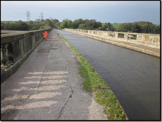
The Lune Aqueduct

Workmen were rebuilding the banks of the canal hereabouts, and at a spot to the south of Lancaster, and the steep steps referred to below are being reconstructed.

After viewing the aqueduct descend steep steps immediately before the bridge to a disused railway line on the banks of the River Lune. Follow the pathway back through Riverside Park and past Skerton Bridge into the city centre.

Staying on the riverside path pass under a subway next to Greyhound Bridge and proceed to the Millennium Bridge (pedestrian), known locally as the 'swearing bridge' due to its two masts resembling that of 'V sign'. Follow the road along St. George's Quay, under Carlisle Railway Bridge and beyond along New Quay Road. After passing the end of warehouses on the industrial estate, take the riverbank footpath (LCW), follow this along the flood embankment to reach a stile near Aldcliffe Crossing. Cross the stile to follow the disused railway track back to Conder Green.

By now, at this time of year, you should have spotted goldfinches in the hedgerows and numerous further wild flowers, including Parsleys, Clovers, Himalayan Balsam (thankfully on the wane), Red Campion, Bramble, Bush Vetch, Hedge Bindweed (pictured below), Yarrow, Meadow Cranesbill, and several varieties of Aster.  There’s also a plethora of berries.

Hedge Bindweed (Calystegia sepium)

Autumn berries 
The final section of the walk, after the rigours of the flood embankment (see slide show for more) is a gentle 4km stroll down this lovely disused railway line, where there was a steady flow of commuters on bicycles whilst I strolled along, reaching the end of a very pleasant day’s walking at about 5.15 pm.

The disused railway line approaching Conder Green 
Here’s the map from the website.

The 22 mile route, from the Breath of Fresh Air website

Here’s the route according to Anquet:

A Breath of Fresh Air - 35km, 250 metres ascent, 7 to 8 hours

And here it is according to the Garmin gadget that recorded all my errors and extra wanderings – 37km but only 133 metres ascent.

Thanks go to Norman for devising this fine route.

*  It was an almighty crash.  The VW Polo’s rear bumper must be very flexible, as it seems to have survived with only a scratch!

Wednesday, 5 October 2011

Summer in Timperley

Shaggy Caps by the Rochdale Canal

We returned from Scotland to weather reminiscent of our recent trip to Turkey – constant blue skies and pleasant warmth.

It’s a shame that ‘home admin’ rather got in the way, and particularly galling that we chose to spend one of the best mornings on Sue’s ‘once a decade’ trip to a car showroom (although pleasing for her to find that prices are the same as ten years ago!).

A few short trips were however enjoyed, and after Stumpy’s failure the old Shogun Trail Breaker bike enjoyed a few outings (it’ll still be used for flattish trips around home after Stumpy has passed his medical).

Here’s Shogun, on the Trans Pennine Trail path around the edge of Carrington Moss.  At this point, between Ashton upon Mersey and the chemical plants of Carrington, the old Moss (bog) has long since been used for agriculture, and on this day (30 September) four tractors were feverishly at work in this huge field.

On the Trans Pennine Trail at Carrington Moss

It’s a pleasant circuit from Timperley – the 14 mile route is shown below.  If you can do it in an hour, you’re a lot fitter than me!

The Bridgewater Canal looked in great form in Sale, on this glorious day.

The Bridgewater Canal in Sale

It’s definitely autumn, though, with spiders very active around the house, and mushrooms sprouting all over the place.

Here’s George, who guards our porch.  He has a velvety coat which is lovely to stroke, but I’m not sure whether he appreciates the attention – he has now moved to a more secluded location.  He’s a cannibal, by the way, but is probably no more edible himself than the Shaggy Caps (aka Lawyer's Wig) (Coprinus comatus) that I discovered in Newton Heath, beside the Rochdale Canal, on Sunday morning.

George, our pet spiderShaggy Caps (aka Lawyer's Wig) (Coprinus comatus) - inedible

It was my second trip by bike from home to Sholver, this time a bit quicker than my first attempt (see here), though by now the weather had deteriorated a little.  Sections of the canal are currently atrociously loaded with rubbish and Canadian geese, but the autumn colours are developing nicely, as here in Failsworth – not known for its colourful countryside.

The Rochdale Canal in Failsworth

A dog at Fullwood


This small dog bravely investigated my passage after I’d taken a cross country route from Rochdale to Shaw.


Kate and Jacob were in good form, as were Simon and Oscar, as we all enjoyed a stroll around Crompton Fold.

Kate and Jake at Crompton Fold

Then autumn arrived…