Sue and Martin in Mallorca 2019

Sue and Martin in Mallorca 2019
On the Archduke's Path in Mallorca

Friday, 4 May 2012

Nelson Peach – Jack Frightenem Goes Viral?

Nelson Peach - Jack Frightenem

Sue and I were privileged last night to attend the launch of Cult Folk Band, Nelson Peach’s latest CD launch.

It was an excellent evening, very well attended, with lots of chocolate pudding Jennings Cumberland Ale.

Well done, Richard, Lesley and Rick, pictured below, from a distance, with a very weak flash, from a drowned camera.

Nelson Peach at their Jack Frightenem CD launch on 3 May 2012

I understand there has been a ‘run’ on stock of this fine CD, so readers should order now from the foot of this page to avoid disappointment.

Thursday, 3 May 2012

Who ate all the Chocolate Pudding?

Backpackers in the Egerton Arms

I’ll give you one guess.

“Just bulking up for the TGO Challenge” quipped the culprit.  Fair enough, I suppose, he/she had walked 50 miles on Saturday “to loosen up for The Challenge”.  A first-timer whose spoon had failed to reach stared longingly at the well-licked plates.  Another, a seasoned Challenger who isn’t doing it this year (Fort William to Edinburgh has preference) looked on, with a knowing grin.

Such was the excitement to be gained from last night’s bi-monthly ‘Backpackers Meal’ – this time at the Egerton Arms, Astbury, whose restaurant behaved very understandingly on the night, as our meal time was delayed when a '”we’ll be there in five minutes” message turned into a half hour delay.  There is more than one Egerton Arms in Cheshire….

The loudest laughs of the night were however reserved for a Challenger who was absent, but who has recently published a kit list with a glaring missing item.  Personally, I think he deliberately missed off the vital piece of equipment just to wind the rest of us up.

Wednesday, 2 May 2012

Curious Brothers

The Curious Brothers - two ibex in the Maritime Alps

I entered this image of two young ibex in the Austrian Alpine Club Photo Competition (2011).  It didn’t win anything.

However, it’s more interesting than the pictures from Timperley this week, where I’ve been ensconced at home whilst our garden fence has been most effectively replaced by Ian, Mickey and Jay, from CL Fencing Services.  At least that gave me a chance to print our maps for next week’s TGO Challenge and order a few consumables from Bob and Rose, Webtogs, and others.  Annoyingly, the closure of Milletts in Altrincham leaves us with no local outdoors shop, so I’ll have to go into Manchester to buy new boot laces and proofer.

There still seems lots of ‘House Admin’ to do before we set off this time next week to start The Challenge, but I’ll try to make one or two postings in the meantime before the routine of daily ‘mobile blogging’ takes over.

Saturday, 28 April 2012

Tuesday 24 April 2012 – An Evening Stroll on the Sandstone Trail

Sundown on Snidley Moor

The venue for tonight’s evening walk was Beacon Hill, near the start of the Sandstone Trail.  I had thought I might be alone, but Sue made time to come along, as did Richard and Andrew.

We enjoyed a delightful evening, pausing on Woodhouse Hill to admire the views across to Liverpool and The Wirral, not to mention the Welsh mountains.

Admiring the view from Woodhouse Hill

In days past this high ground was favoured by early settlers because the heavy clay soils of the plain gave rise to a landscape of thick woods and poorly drained mosses (think of parts of modern-day Delamere Forest).  The hills were drier and had light, sandy soils which were easier to work and not so densely wooded.  Lines of communication during this period may also have followed the sandstone ridges, on which there is plenty of evidence of ancient (circa first century BC) hill forts, built in the years before the Roman occupation.

On Woodhouse Hill

The sandstone hills themselves were shaped by ice sheets during the last ice age, between 75,000 and 10,000 tears ago.  Until well beyond the Middle Ages, tidal marshes and reedbeds reached far inland.  But the building of the Manchester Ship Canal around 1894 brought major changes.  The ‘Big Ditch’ as it was known, cut off the marshland from the sea, releasing much of the wildlife rich wilderness for farming and industrial use, as you may surmise from the poor sunset picture below (taken with the ‘drowned’ Ixus 105 camera on its fourth temporary resurrection – Richard’s iPhone images should be much better).

Sunset from Woodhouse Hill

After a while it got quite dark, so our visually challenged member resorted to torchlight, but the ambient light was sufficient for the rest of us to safely regain the Simon’s Lane car park (SJ 518 766) before adjourning to the Bull’s Head to admire the thrashing of Barcelona by the most unlikely of opponents (Chelsea, for the record) and enjoy a blather with a beer.

This 10 km (6 mile) route is an excellent introduction to the 34 mile Sandstone Trail.  Allow 2 to 3 hours.  A shorter version is described here.

Our route - 10km, 250m ascent, about 2.5 hours

Postscript:

Conrad took one look at the sunset image and thought he could improve it in Photoshop.  I’d already improved it from this original:

Sunset from Beacon Hill

But Conrad did even better:

Sunset from Beacon Hill

The escarpment is Helsby Hill.

Friday, 27 April 2012

Scotland – Monday 16 to Sunday 22 April 2012

Jutta, Robert and Wolfgang with The Quiraing behind them

Monday 16 April

I reported on a sunny drive to Skye here.  This posting summarises ‘Monday to Friday’ and gives a little more about the weekend.  If you prefer just to look at the pictures, they are here.

My sunny drive was punctuated by many pauses, notably at Loch Laggan, at the War Memorial near Spean Bridge, with views of Ben Nevis clear of cloud, and by Loch Loyne, to admire the mouthwatering western summits beyond the loch.

From Loch Duich there was a good view to the distinctive slopes of A' Ghlas-bheinn in the background, with the slopes of Beinn Fhada to its right.

A' Ghlas-bheinn and Beinn Fhada from Loch Duich

Soon afterwards the Skye bridge and the Cuillin hills beckoned enticingly, and Seaview Guest House in Broadford was a welcoming venue for a reunion with Wolfie and Jutta, who with their friend (and my room mate) Robert made up this year’s complement of the ‘Dornbirn Crew’.

Skye beckons the traveller

The trio had just finished a B&B trip along part of the Skye Trail, and we enjoyed a pleasant evening and a satisfactorily spicy meal in Kyleakin’s ‘Indian’ (actually Bangladeshi) restaurant.

Tuesday 17 April

We wisely scrapped a plan to slog up Glamaig in the rain, in favour of a trip to The Quiraing which the others had not previously visited. My report on that day is here and as always there are lots more pictures in the slide show here. By way of a flavour, here’s Jutta after ascending through The Prison gully.

Jutta ascends through The Prison

We (except Robert who declined to ascend due to his vertigo) enjoyed lunch on The Table, and we regrouped in good weather for a jaunt up to the easy summit of Bioda Buidhe, and some really excellent views.

Here’s our route - 10km, 650m ascent, taking around 4.5 hours including breaks.

Monday's route - 10km, 650m ascent, 4.5 hours

Dinner was taken at Coruisk House in Elgol.  Good food in an interesting place, and I have to thank Markus, Wolfgang’s brother, for paying my bill (all the way from Dornbirn!).  I have some very generous friends.

Wednesday 18 April

Leaving the ‘Dornbirn Crew’ to make their way home, I enjoyed another sunny drive, this time to Arnisdale.  Frequent photo pauses - Loch Duich, Kintail Lodge Hotel, another view of A' Ghlas-bheinn, this time from Mam Ratagan, Beinn Sgritheall’s snowy northern slopes, resulted in a very slow journey.

My contemporaneous report on the day is here.

The stalkers path up to above the Eas na Cuingid cascade is very easy, and beyond that, even though the route abandons the path, the ascent of Beinn nan Caorach is really very straightforward.  I suspect that Alistair P plans to go up Beinn na h-Eaglaise before Beinn nan Caorach on next year’s TGO Challenge – that would be a brutally steep, if easy, ascent from Arnisdale, or a scrambly ascent from Bealach Arnasdail if he chooses that route.  I may be in the same area!

Beinn nan Caorach, sports great views of Beinn na h-Eaglaise with Beinn Sgritheall behind, and Ladhar Bheinn can be seen in its full glory standing impressively behind Loch Hourn.

From Beinn na h-Eaglaise, Rum is clearly seen, but all bar the southern tip of the Cuillins are hiding behind the bulk of neighbouring Beinn Sgritheall.

On the steep descent from Beinn na h-Eaglaise after easily gaining the small lochan at Beinn Bhuidhe, lousewort was flowering, and on the lower slopes spring was coming along fine, the call of the cuckoo being accompanied by the sight of primroses, dog violets, lesser celandine, cuckoo flower, gorse, and more.

These docile highland cattle squinted at me as I passed, but the nearby herd of deer (see slide show) was a little more jittery.

Highland cattle in Glen Arnisdale

This most enjoyable outing, finishing just as some rain came in, was followed by a scenic drive to Newtonmore, and a welcome from Sue and Neil at Newtonmore Hostel.

Here’s today’s approximate route - 15km, 1000m ascent, taking 5 hours including breaks.

Tuesday's route - 15km, 1000m ascent, 5 hours

Thursday 19 April

Today’s contemporaneous report is here.

Basically, I enjoyed a walk from Kingussie with Sue and one of her three lurchers, Harvey.  The sun came out as we strolled up Glen Gynack  but by the time we reached a lunch hut we were glad of the shelter.

After winding through the mist from Beinn Bhreac, we were pleased to reach the summit of Carn an Fhreiceadain (878m) – this would be a very easy tracked route in good weather with no snow cover, but the swerving track did nearly fool us at one point.  We passed a strangely large cairn on the way down and even met three old fogeys ascending this easy Corbett, a rare encounter by the week’s standards.

Here are Sue and Harvey, eying up a spot for lunch by Allt Mor.

Sue O and Harvey scout for a lunch spot beside Allt Mor

Here’s today’s approximate route - 19km, 670m ascent, taking about 5 hours including breaks.

Wednesday's route - 19km, 670m ascent, 5 hours

I spent a second evening in the Glen Hotel, after brewing up a sumptuous pasta on the hostel stove, this time with a JOGLE cyclist, Sam, who helped me fail to assist a family from Birmingham in their quest to win the Pub Quiz.

Friday 20 April

The further west I went, the fouler the weather became.  I nearly abandoned walking today, but after lunch in the car at the Linn of Dee I decided to give it a go, if only to stroll up to White Bridge and back.

As it was, the rain stopped as I strolled alongside the River Dee, observed by the first wheatears I’d seen this year.  Beyond White Bridge water was rushing down the Chest of Dee’s rapids.

Chest of Dee rapids

Sgor Mor’s 813 metre summit was gained after a bit of a thrutch through deep heather, but the 3km ridge walk to Sgor Dubh’s 741 metre summit was a delight, though the higher Cairngorm peaks were sadly enveloped in cloud.

It actually turned into a sunny afternoon in the Dee valley after a steep final descent through deep heather, before I pootled back to Craiglea B&B in Braemar to write up my report on the day before being joined by The Workers – Sue, Lyn and Alastair.

Here’s my route for the afternoon - 17km, 500m ascent, taking 4.25 hours including breaks.
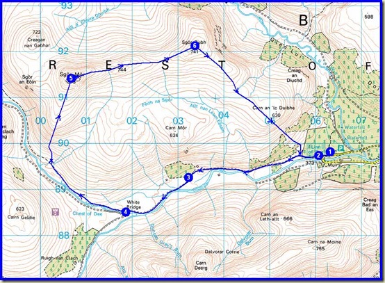
Thursday's route - 17km, 500m ascent, 4.25 hours

Saturday 21 April

Fortified by an excellent meal at Moorfield House Hotel, and by Dave and Angela’s fine breakfast, we felt able to tackle something hilly despite rather iffy weather.  Al’s original plan for a long day up Beinn Bhreac and Beinn a’ Chaorainn was discarded in favour of an easier route over An Socach, taking advantage of the luxury of having two cars at our disposal.

Sue chatted to the horses at Baddoch whilst the rest of us faffed with our equipment, before we set off at a cracking pace up the glen beside Baddoch Burn for about 6km.  Well, the others set a cracking pace; I was in ‘holiday mode’.

After catching them up when they stopped for elevenses, I watched them disappear into a cloud ahead as we ascended the fairly benign slopes of An Socach.  At least, they seemed benign to me so long as you kept to the left of a snow filled gully.  The others had apparently waited there, in a cloud, for me to turn up, so the 944 metre summit was deserted when I reached it.

I always knew they would turn up, as Al and Lyn had not been here before and Al needed to tick it off us ‘bagging’ list.

We were in and out of cloud as we descended to the north, but the long valley that is Glen Ey soon appeared for good.

Looking down to Glen Ey from An Socach

A steepish descent, during which Sue tried to wreck her overtrousers by bum-sliding over heather, took us to a delightful lunch spot, after which we continued into the long valley along deer trods, eventually crossing the Ey Burn cascade at the ruins of Altanour Lodge, from where an excellent track runs all the way, over 8km, to Inverey.

Four cyclists on hire bikes passed us, presumably having bagged the Munros - Carn Bhac and Beinn Iutharn Mhor.

Half way down Glen Ey, Sue spotted a big bird.  It was great to watch the golden eagle soaring for some time close above the slopes of Creag an Lochain before landing in a tree.  Oyster Catchers also accompanied us today, together with dippers, curlews, golden plovers, some ducks, and several smaller unidentified birds.

A couple of bridges over the Ey Burn later, and “we must be getting close to Inverey, mustn’t we?” by which time the sun had emerged.

On our way back to Craiglea B&B (Dave and Angela) we called in at Thornbank to visit Simon and Kat, who fed us with delicious žemlovka.

Visitors to Braemar may enjoy a visit to Thornbank, where Kat can apparently provide miraculous therapies for certain ailments – see here.  Sadly she won’t be in town during the imminent TGO Challenge, and Sue will be too busy cooking my tea to offer services in the ‘therapy room’!

Here’s our route for the day - 21km, 550m ascent, taking 6 hours including breaks.

Saturday's route - 21km, 550m ascent, 6 hours

The Moorfield provided more excellent nosh.  But we were the only customers, not that anyone seemed to mind or even look worried.

Sunday 22 April

Simon joined us on this last outing of the trip. After dumping some cars at the Spittal of Glenshee, we returned up the pass for an easy 35 minute stroll to reach our first Munro of the day, Carn Aosda.

Group on Carn Aosda (917m)

45 minutes later, on a pleasant but overcast day, we'd reached the ugly summit of The Cairnwell (933m), our second Munro of the day.

Returning to an old sign, we took the ridge to the south of Loch Vrotachan.

It's quite a broad ridge - no dangers here - with Carn nan Sac  a fairly short walk away, providing a mid point on the walk to our final Munro summit of the day.

There’s a good view to the south east from Carn nan Sac, beyond a prominent cairn, across to Creag Leacach, the other side of the A93 road.

There was snow lying above 850 metres or so, but although it was very soft it wasn't deep enough to hinder our progress.

A little over an hour after leaving The Cairnwell, our third and final Munro of the day was reached - Carn a' Gheoidh (975m).
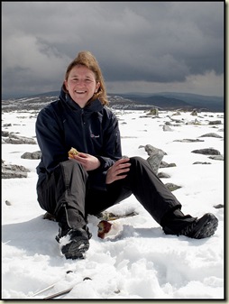
Lyn on Carn a' GheoidhAl on Carn a' Gheoidh

After a short break on the summit, we headed to a more sheltered spot for lunch - not that it was very windy – after admiring the view south, with Carn Mor and Ben Gulabin ahead.

The steep snow was too soft for glissading, but we soon reached the subsidiary summit, Carn Mor, where Lyn seemed to spend the whole time peeling off her overtrousers whilst the rest of us enjoyed our lunch.

We enjoyed the views towards Glas Tulaichean for the rest of our walk.

Glas Tulaichean from Carn Mor

A large group of ramblers approached from the south as we ambled off Carn Mor.  “We are the Dunperthing Rambling Club” announced their spokesman, “today we are going up Carn Mor.  Is it far to the top?” adding, under his breath:  “Which club are you in?  You don’t seem to have many members.”  I explained that we were a group of private individuals and that we had ‘permission’, and left it at that.

As Ben Gulabin got closer, a wide and brutal ascent path was revealed – it turned out to be as steep as the ascent up into The Prison in the Quiraing.  Thankfully it was almost as short and a little while later we were enjoying a siesta on our final summit of the trip - Ben Gulabin (806m) - on a warm April afternoon.

In the sun on Ben Gulabin (806m)

Having admired the views at length, we then headed off home, and as customary during the course of this week, the sunshine heralded a shower, so we just failed to reach the cars left at the Spittal of Glenshee before the rain came ...

Never mind, our clothes are all dry now!  I think.

Here’s the day’s route - 18km, 800m ascent, in a shade under 6 hours including breaks. (Three very easy Munros and a Corbett.)

Sunday's route - 18km, 800m ascent, 5.75 hours

There’s a fairly lengthy slide show here, if you can stomach it.

Phew!  I’ve had this posting hanging over me all week.  Time to move on…

Friday, 20 April 2012

Friday 20 April 2012 - SgĂ²r MĂ²r and SgĂ²r Dubh

Sam was more reliable than the previous night's Frenchies. This 'gap year' nineteen year old from Witney was finishing the second day of a JOGLE (John O'Groats to Lands End) bike ride when he arrived around 6pm. He rested whilst I cooked some pasta, then we strolled round to the Glen Hotel, where Chelsea's glorious victory last night over Barcelona had been forgotten in favour of a pub quiz with lots of intervals. Whilst Sam chomped on a venison burger we joined a friendly family from Birmingham, but we really weren't much help. I wasn't, anyway. We were one point away from the prizes in both the picture quiz and the main quiz. The man who had swaggered in with a huge trophy - Mastermind 2012 (Newtonmore) - was clearly on a roll and his team took the £25 first prize.

Today I enjoyed a slow start and a chat with Sue O, the proud owner of three lurchers, before taking the wrong route to Braemar. I'd forgotten that the main road from Tomintoul to Ballater was closed. Oops!

The morning was pretty wet, so I was happier passing through the downpours in the comfort of a car than I would have been on foot.

By the time I set off from Linn of Dee it was nearly one o'clock. At least I could carry my lunch in my stomach.

The sky tap was turned down to a dribble for most of my 17km clockwise circuit of Sgòr Mòr and Sgòr Dubh via White Bridge and the Chest of Dee. A pleasant circuit in a shade over four hours, during which I saw my first wheatears of the season. The 3km ridge between the two summits, in and out of cloud today, was very easy going, with finer views on a better day of the main snow clad Cairngorm massif. Deep heather on the steep ascent to and final descent from the ridge made for careful, slow going, apart from which it was pretty much of a romp, except that every time the sun came out it started to rain.

Today's summit picture is very much like yesterday's, minus Sue O and Harvey (sorry to confuse you, Alan), so today's image is of the River Dee near White Bridge, during one of the afternoon's brighter periods.

Sue B, Al and Lyn are due imminently to arrive here at Craiglea B+B in Braemar, and a jolly evening will be had at the Moorfield.

I may leave further reports from this trip until Monday, so don't worry (mother!) If everything goes quiet until then...

Have a great weekend, everyone.

Thursday, 19 April 2012

Thursday 19 April 2012 - Harvey's First Corbett

Today dawned fine and leisurely. Happily Sue found time to join me for a walk from Kingussie, together with four year old Harvey.

A by now overcast day saw us plodding slowly up Glen Gynack towards Pitmain Lodge, where a huge new building is going up.

Harvey's ablutions were dealt with and we continued on up the path to a conveniently positioned lunch hut. Elevenses revealed my failure to re-stock the shortbread box, but at least there was a piece for Sue. "Harvey wouldn't have liked it anyway" observed Sue, "he prefers hares or ptarmigan" she added later, as he strained on the leash in their presence.

As we rose up the slopes of Beinn Bhreac, the path that stops on the Ordnance Survey map continued all the way to the summit as we passed through a fresh snowfield that became even fresher as we passed through the flaky cloud.

A winding track then delivered us to the 878 metre summit of Carn an Fhreiceadain. It wasn't entirely clear where we were, so I turned on my Satmap GPS. It was intent on plotting a route, as the crow flies, from Skye to Westminster (700km - I'm sure someone might like to know). So Sue turned on her Garmin Geko which "always tells you where you are". It didn't, preferring to interrogate the user about its 'settings'. Eventually, after numerous random pressings of buttons, the Satmap gave us our location, on the correct path to the summit. It was just as well the gadget remained turned on, as we immediately set off in the wrong direction.

Anyway, the header image should confirm that Sue and Harvey, her placid rescued lurcher, did eventually make it to the top of Harvey's first Corbett.

The descent was easy, as we soon freed ourselves from the cloud and any precipitation reduced to a very light mizzle.

Three old but jolly men were ascending, the only people seen on the hill today, and after lunching in a pleasant spot by Allt Mor we continued on back to Kingussie after about 19km, 700 metres ascent, and 5 hours.

A very jolly little outing, and thanks go to Sue and Harvey for finding time to accompany me, and to Neil for not seeming to mind being left behind with the tough job of cleaning the hostel after last night's occupants. Apart from me a French couple had arrived at around 1.30am! So any mess was probably mine!

Wednesday, 18 April 2012

Wednesday 18 April 2012 - Beinn nan Caorach and Beinn na h-Eaglaise

An early start for the Dornbirn Crew had them heading off to Stirling via the ferry to Mallaig. They had enjoyed their food last night, at Coruisk House in Elgol, as had I - especially as Markus (in absentia) was treating me as a thank you for my help with his imminent Fort William to Cape Wrath route and maps. Thanks Markus, you are a star.

As for Sue's shortbread, it received an even greater accolade - voted 'best ever' by the Dornbirn Crew. And unlike other fayre, it wasn't affected by 'Skye Speed' (or lack thereof). Nor was the excellent breakfast at Seaview, where I reluctantly left Penny and Bill, a most entertaining 'double act' after a very pleasant stay at the B+B that they bought on impulse six years ago.

On reflection, on this beautiful morning, I might have reverted to yesterday's 'Glamaig Plan', but having enjoyed yesterday's visit to the Quiraing so much - I've been there many times but it never ceases to enthral me, The Table is one of my favourite places - I was happy to head back over the bridge and beside Loch Duich to Shiel Bridge.

The single track road over Mam Ratagan was busy. I paused for a number of 'photo stops' but the light or the trees always seemed to foil the 'perfect shot'!

Arnisdale welcomes walkers. There is plenty of parking by the seafront. I was today's only walker. Setting off at 10am, I headed around the two Corbett summits of Beinn nan Caorach and Beinn na h-Eaglaise in an anti clockwise direction - a straightforward five hour (15km, 1100m ascent) walk under the unceasing watchful bulk of Ladhar Beinn.

Reflections in the loch were indicative of a windless day, as a heron lazily flew over the greylag geese.

The call of a cuckoo filled the otherwise empty air as I ambled up the excellent stalkers path past the cascade of Eas na Cuingid.

No gloves needed today, just t-shirt and fleece, despite the summit snow.

The plaintive calls of a pair of golden plover rang out as I paused on the descent of Beinn nan Caorach to take advantage of the light for today's image. The second Corbett, Beinn na h-Eaglaise, is on the left, with Beinn Sgritheall's higher peaks to the right.

There were fine views of a vast array of summits from the 804 metre climax of the impressively narrow ridge of Beinn na h-Eaglaise.

After tea and shortbread on this second summit, an unrelentingly steep but safe descent past early lousewort and ptarmigan still wearing their white winter vests, led to a zone of dog violets and primroses. Lower down, lesser celandine, cuckoo flower, dandelions and gorse were all flourishing. A swan flew over the highland cattle - it wasn't mute, it was whooping.

Finally, a large herd of deer, one of several groups seen today, seemed quite at home in Glen Arnisdale near Corran.

After this enjoyable solo outing on the deserted hills above Arnisdale, the three hour drive to Newtonmore passed quickly. Perhaps I slept.

Tonight I enjoyed a seafood platter at the Glen Hotel, just across the road from the Hostel now being run by TGO Challenger Sue Oxley and her husband Neil. They were busy over Easter, but tonight I have the place to myself. I think I'll donate a 'single room supplement'.

Tuesday, 17 April 2012

Tuesday 17 April 2012 - The Quiraing

After an excellent spicy Bangladeshi meal at Kyleakin, we slept well but woke to drizzle and low cloud.

My plan to nip up Glamaig was discounted - fortuitously as it turned out, as Robert suffers from vertigo to a debilitating extent.

So after Bill and Penny's sumptuous breakfast at Seaview Guest House, we headed up past snow capped Glamaig, past The Storr and through Staffin to Bealach Ollasgairte.

The rain had by now stopped and we encountered just a bit of drizzle on the early stages of our walk past violets and daisies on the walk in to The Quiraing. By late afternoon in Broadford we have a very sunny 'Sea View'.

Visitors to Skye will probably be familiar with our itinerary - a 6 km jaunt along the good path to The Quiraing, which means 'fold' or 'pen'. To our right, an outcrop that I had always thought was The Prison. We climbed nearly to the summit, leaving vertigo stricken Robert cowering behind a rock near the bottom.

Back on the main path leading to Flodigarry, a small cairn at the high point marks the start of the steep path up to what I now know really is The Prison, which is enclosed by a jumble of needles, towers, pinnacles, gullies and cliffs.

Robert looked up and felt sick. So the three of us left him and headed off into this 'wonderland' to The Table, a horizontal platform of grass that is the centrepiece of The Prison. In days past, livestock was apparently hidden up here to conceal it from Viking raiders.

Lunch was taken on the lawn, under the watchful eye of some people on the main ridge - not far above us but pretty inaccessible from where we were. Beyond the lawn - lovely views, albeit slightly obscured by the showery weather.

It didn't take long to slither back down a gully under the watchful caw of a raven, back to Robert and back along the well repaired path to the bealach, where we were greeted by a coach load of mainly Japanese tourists mainly in wellington boots.

With time on our hands, we then enjoyed a further 4 km ramble up to the summit of Bioda Buidhe (466 metres), from near where the header image of the Dornbirn Crew was taken, with The Quiraing in the background. (Too easy for a quiz, Gibson!) We returned to be greeted by a kilted bus driver with a coach load of 'Wild and Sexy' passengers. The mind boggled!

A visit to The Quiraing is always a pleasure, and today's was no exception.

Monday, 16 April 2012

A Sunny Day for a Drive to Skye

With a few things thrown into a bag I managed to leave Timperley by 9am on a bright sunny morning.

And the sunglasses stayed on all the way to Seaview B+B in Broadford, with many stops for roadworks and snaps during the latter part of the journey. Sadly the best views always seemed to be directly into the sun. But can you recognise where today's snap was taken from?

Not even the Ben had a hat on, the visibility was excellent and the views were fine, with just a splash of recent snow on the higher summits.

Wolfgang, Jutta and Robert, the 'Dornbirn Crew' were already installed at the B+B, so I've just time for a mug of tea before we nip off for an Indian meal.

Snow is forecast, but there should be a walk tomorrow.

Monday 16 April 2012 - Another Trip!

Alpine Reflections

Today I’m booked into a B&B in Broadford, together with Austrian friends Wolfgang and Jutta, and Robert, a complete stranger with whom I’m sharing a room.

On Tuesday we’ll do something on Skye.

If anyone would care to join me, I have a few days to fill before meeting Sue in Braemar on Friday, as there seems little point in returning to Timperley.  I’m planning the following:

Wednesday – Beinn nan Caorach and Beinn na h-Eaglaise from Arnisdale.

Thursday – Carn an Fhreiceadain from Newtonmore Hostel.

Friday – Sgor Mor from Linn of Dee.

Call me or leave a message on mobile@topwalks.com if you fancy any of these.

Martin

I’d better get going!

Sunday, 15 April 2012

Saturday 14 April 2012 – The Calderdale Hike

Martin and Richard after the 26 mile hike

With Robert in Mallorca, and others lacking energy or interest, I’d set myself a modest target of eight and a half hours for this year’s Calderdale Hike, along a new 26 mile route.

That was until a call from John at the Austrian Alpine Club suggested we arrive at Crowden by 6pm for an evening I’d expected to start at least an hour later.  With Calderdale and Crowden both not much less than an hour’s journey from Timperley, that created a little time pressure.

So, with plans to travel directly to Crowden from Calderdale and meet Sue there if necessary, I jumped out of bed at 6.30, scraped the ice of the windscreen, and made it up to Sowerby Bridge in time to hand back last year’s trophy and get my kit checked before the 8am start for the short (26 mile) course walkers.

Here we are, milling around on the sunny morning before the 8am start of this year’s Calderdale Hike.

The Calderdale Hike - waiting for the start

Philip Whitaker (who I may have mistakenly maligned in the past for running – I apologise if that was incorrect, I don’t think he ran today) set off at a blistering pace.  He has very long legs. 

“Hello, I’m Richard.  Are you Martin?” asked a complete stranger.  He turned out to be a ‘blog stalker’ who had found my previous scribblings about this event, which he was entering for the first time.  Richard had reconnoitred some of the route, and he could match my pace, so that was very helpful.

Here he is on the descent to Hoo Hole near Mytholmroyd.

Descending towards Mytholmroyd

Philip disappeared ahead into the far distance.  We would never catch him – he finished over twenty minutes ahead of us, regaining the Veteran Walker trophy that he and I have both won on several occasions.  On the other hand, two youths and a couple were on our tails as we ascended to Stoodley Pike Monument, and a short cut on the way down from there took these four ahead of us until all six of us were held up for a few minutes by a farmer moving some sheep along the narrow path.  He got quite frustrated with our perceived impatience. 

We apologise…

After excellent refreshments at Lumbutts we negotiated our way through Todmorden and up to the golf club for the next checkpoint.

We nearly made the mistake of following the runners on the long course – they had started an hour later than us – but then realised we should turn in our tracks and return past the sad looking church at Hole Bottom, where the clock face has been replaced with an alarm box. 

The derelict church at Hole Bottom

Across the valley, Stoodley Pike Monument already appeared quite distant.

Stoodley Pike from Hole Bottom

By now the weather had changed, and we narrowly missed some sharp showers on what was now a rather grey day.  But it was good walking weather and we sped on at an admirable pace, leaving the young lads and the couple behind.  We didn’t see anyone on the 26 mile walk after Hole Bottom, about a third of our way along the route, but we were regularly passed by runners, including Richard’s doctor.

With a vast choice of routes between the checkpoints, we chose a blend of country lanes and moorland trods.  The latter were quite boggy as we crossed Heptonstall Moor to reach Blake Dean, where Richard had a longer than usual wait for me due to my longer than usual ablution stop on the moor, which thankfully was vacant at the time.

Moving quickly on, we enjoyed the very pleasant stroll past Hardcastle Crags to Gibson Mill, a National Trust property well known to Richard.

Gibson Mill near Hardcastle Crags

After failing to spot that the New Bridge checkpoint was hidden up a hill in the upper car park (we eventually found it) we continued, partly along the Calderdale Way, up to Delf End checkpoint, where the long course runners rejoin our shorter route, so from here we saw more people.

Here’s the support point at Delf End, putting on happy faces especially for the camera as Richard takes on board some liquid.  He was suffering a little up some of the hills by now, but still keeping up a good pace, and he had recced the route from here so he knew the way home.

Helpers at Delf End checkpoint

Manning checkpoints wasn’t the most pleasant of jobs this year, as the intermittent cold drizzle must have been a bit tiresome.  It was a day for down jackets if doing that job.

Nevertheless, by the time Richard and I reached the steep haul back up to Sowerby, the day had improved a bit and Richard had changed his leaky boots in favour of some nice clean trainers for the last few miles, which were largely on metaled lanes and a canal towpath.

Richard ascend to Sowerby

The sun attempted a reappearance as we passed Sowerby’s church on our way back to the cricket ground, completing the 26 mile route in 7 hours 11 minutes, with Philip the only short course walker to finish ahead of us.

Sowerby Church

Luckily our unexpectedly speedy pace left time for a meal and a beer at the cricket club – a tradition that I’d have been disappointed to have missed!

Here’s our route - 42 km, 1350 metres ascent, 7 hours 11 minutes.

Our route - 42 km, 1350 metres ascent, 7 hours 11 minutes

Our route - 42 km, 1350 metres ascent, 7 hours 11 minutes

All in all an excellent day out.  Thanks for your company, Richard, it certainly enhanced the day, hopefully for both of us, and I hope you can find a place in your office for the Clayhouse Shield that you won for being the fastest (non-veteran) walker to finish.  Well done!

This entry has been rather hastily written, due to time pressures, so apologies for that.  Last year’s report is here, and my 2009 report is here.

My Garmin gadget (not turned off for a few minutes after we finished) recorded our route as follows:

PS I did manage to get home to pick up Sue and get to Crowden by 6pm.

PPS Greetings, Michael!  Fancy doing this next year?

Friday 13 April 2012 - The Lancashire Trail – Part 7 – Whalley to Barley

Near the start of the Whalley to Barley section, near Whalley

This penultimate stage of the East Lancs LDWA’s Lancashire Trail ‘Plod’ will officially take place next Wednesday 18 April, but those of us who can’t get to that event enjoyed the privilege of joining Reg on his ‘recce’ of the route.

In the event, the original route from over thirty years ago was proven to have stood the test of time, unlike some of the earlier sections that had needed adjustments following Reg’s recce’s.

We started from Whalley in a jolly mood - Nancy, Jim, Norman, Reg and Martin, as pictured above on the ascent of Clerk Hill, on a rather overcast day that had the pessimists reaching for their waterproofs and the optimists (Reg and me) ignoring any moisture and relying on our fleeces.

A boiler with a big chimney was reminiscent of the early days of steam.  Norman, clearly the only person amongst us who was old enough to cast his mind back to those days, announced "I'm a Master Plumber, I can get this going."

"Press the button, Norman" said Jim.

Boiler men

A hasty retreat was made from Wiswell Moor Houses, from where the nearby hills to the south east were lounging under a light haze.

Did this fine sign herald the time for a decision?  Not really, the Nick of Pendle was our clear and easy objective.

Footpath sign

A good path led towards the Nick.  Suddenly, Norman and his cohorts turned on their leader - "It's gone eleven, why haven't we had a tea break?"

Rebellion

"Ok" replied Reg, and we all sat down.

From beyond the Nick of Pendle, expansive if dull views drew the eye far beyond the cement works of Clitheroe.

There was a good path by Ogden Clough, where the sun made a brief appearance.

The ascent of Pendle Hill beside Ogden Clough

Pendle Hill - 557 metres – was eventually summited.  The summit plateau was gained via a superb stone pathway, a great improvement over the eroded bogland that I recall from my youthful visits to this hill.  There were fine views in all directions, albeit a bit hazy, with the distinct outline of Ingleborough hiding behind Norman’s vast bulk.

On the summit of Pendle Hill, 557 metres

Norman (The Clown) tried to fly. "Oops" he exclaimed "I think I’m too heavy for this!"

Norman tries to fly

We met two reprobates with china mugs and large lunch boxes.  I hadn't seen Dave since I bought his old mountain bike from him last year, so we joined the jovial duo for lunch and a chat.

Lunch, with Dave and Alan

Norman and Nancy were tickled by Dave and Alan’s choice of crisp manufacturer.

A ticklish time with Lancashire Crisps

These two jokers were soon seen descending to Barley, hand in hand, with Clenched Buttocks (it’s a long story).

We passed a stream whose banks were loaded with Primula.

Primroses in Barley

Looking back to Pendle Hill, it seemed quite small to me, but I suspect it is the high point of this route.

A fine cobbled path led inexorably to the fleshpots of Barley – a restaurant and a pub, and a cafe…where we all enjoyed a coffee.

Coffees at Barley

Here’s our route - 12 km, 500 metres ascent, taking around 3-4 hours.

Our route - 12 km, 500 metres ascent, 3-4 hours

What a pleasant day.  I hope the actual ‘event’ proves to be as enjoyable for those who go along next week.

My photos from the day can be viewed as a slideshow, here.

Back to Lancashire Trail Index