Sue and Martin in Mallorca 2019

Sue and Martin in Mallorca 2019
On the Archduke's Path in Mallorca

Saturday, 15 June 2013

Saturday 15 June 2013 - Pyrenees GR10 - Day 1 - Timperley to Elsenham

Weather: warm and sunny
Interesting encounters: not a lot

There was an air of anticipation as we left the house this afternoon.  This will be the longest time I've ever been away from home. 

Will I get homesick? 

The journey went smoothly, everything was on time. There were no incidents.  Even Paul Thoreau would have struggled for ammunition. 

A tram from Timperley. 
A train from Navigation Road.
A Pendolino train to London Euston. 
London Underground Victoria Line to Seven Sisters. 
Anglia Regional train to Elsenham. 
Finally, a walk to our B&B - Stansted Lodge, aka Aspens.

So you can guess where we head for tomorrow! 

Had I realised earlier, the journey to Hendaye may have been better planned to take place entirely by train.  I suspect it would be cheaper than the grand total of £220 (for the two of us) that we've paid to travel by train and plane.  However, the B&B is very pleasant and we should get a better night's sleep than on a couchette. 

Sent from our GR10 trip - see here for our itinerary - will day 2 be more exciting? 

Friday, 14 June 2013

A Pyrenean Adventure

GR10route

Sue and I set off tomorrow – on the 16.06 from Navigation Road to Elsenham – on this year’s Alpine adventure, which is in the Pyrenees.

Having walked the HRP (Haute Randonnée Pyrénéenne) in 2004, our path on this occasion is the easier GR10 route on the French side of the Pyrenees.  It’s shown above on Traildino’s map, as a thin red line from Hendaye-Plage, on the Atlantic coast, to Banyuls-sur-Mer on the Mediterranean.

The whole trip will take about two months to cover 900 km (560 miles) in a rather leisurely fashion with plenty of rest days.  We will ascend a total of around 50,000 metres, topping out at about 2,500 metres.

Sue still can’t carry backpacking kit, so she is returning home from Luchon, approximately half way, after a month, as a tent is needed after that.  We have spent the last couple of days booking accommodation for ‘Phase 1’, so we are fairly committed to the itinerary that can be viewed here

I’ve also sorted out a bit of camping gear for ‘Phase 2’ and have today posted it to Luchon – thanks go to Mike and Annette Jones at Villa Portillon for agreeing to store it for me.

TGO Challenger Graham Brookes is planning to join me from Luchon for a wild couple of weeks, up to Vicdessos, following which I’ll enjoy my own and random bodies’ company for the stroll to the Med.

I’ll enjoy composing regular postings, though I still have much to learn regarding the S3 phone.  I hope you’ll enjoy reading them.

Regular readers may be familiar with this picture of one of our best camping spots from 2004 (there were lots of very good ones), by Lac d’Ansabere.

blog-080504-ansabere

Have a great summer, everyone.

Thursday, 13 June 2013

Tuesday 11 June 2013 – An Evening Stroll Around Delamere

1101Eddisbury

This evening walk was a similar route to that taken with Richard and Jenny on 7 September 2008, when I wrote about it in a little more detail, here.

This time we started from the Visitor Centre near Delamere Station, with Andrew, Bridget and Mary, and soon found ourselves admiring the views from the ramparts of Eddisbury Hill.  The header picture shows the immediate surroundings – looking down to Delamere and Blakemere Moss, but the wider view spanned the Cheshire plain, with the Peak District on the horizon and Jodrell Bank telescope just visible in the middle distance.

Here we are, after rounding Eddisbury Hill and joining the route of the Roman Road that used to link Manchester with Chester, the Watling Street..

1102group

Modern farmland has obliterated most signs of the ancient heritage of this area, but Eddisbury Hillfort is the largest and most complex Iron Age site in Cheshire, and there are well concealed remains of the later Roman presence.

The path eventually reached a junction where we turned right, and we were soon greeted by this unmistakeable evidence of the Sandstone Trail.

1103sandstoneTrail

After a couple of easy miles through pleasant woodland, I decided the assembled company might prefer not to go all the way to Frodsham on this occasion, so we turned back towards Delamere, passing Blakemere Moss just as hundreds of Black-headed Gulls were coming in from all directions to roost for the night.

1104Blakemere

This was an excellent breath of fresh air on a pleasantly warm evening, and very sociable to boot.

Here’s what my Garmin Gadget thought of the route, should anyone wish to follow in our footsteps:

Tuesday, 11 June 2013

Newgale Sands to Abercastle – June 2013

0165SolvaInlet5

This is basically an index page for our recent 70 km series of day walks based in St David’s.

Here are links to the individual postings made ‘from the trail':

You can click them in order, returning each time to this page by clicking on the Back button (the arrow pointing to the left at the top of the screen).

Day 1 – Newgale Sands to St David’s

Day 2 – St David’s to Whitesands Bay and back to St David’s

Day 3 – Whitesands Bay to Porthgain

Day 4 – Porthgain to Abercastle

I’ve done a couple of slide shows:

Mainly for those who were on the trip – 210 images here.

For those who are content with a few of the images – 71 images here.

Press the ‘Slideshow icon to see the slideshow, and to view the pictures on the full screen, pressing F11 may work.  Press ‘Esc’ to revert to the normal screen.  To go through the images at your own pace, hover over the bottom of the screen and press the ll ‘stop’ icon.  You should then be able to move through the images in your own time using the arrows on your keyboard. 

0131scene

Enjoy!

Monday, 10 June 2013

Friday 7 June 2013 – An Alderley Circuit, with Buttercups

0715view

Sadly, only Andrew was able to join me on a gloriously sunny summer’s day for this postponed (from snowy 22 March) ramble around Alderley.

Two and a half months make a huge difference.  Everything is now pretty dry, the buttercups and other flowers are in full bloom, and the trees are in full leaf.

0701woods

We started from the National Trust car park, wandering past The Wizard restaurant, whose former name, the Miners Arms, gives a clue to the industrial heritage of the area, to reach the site of the Armada Beacon.  There’s a plaque here now, but from 1779 to 1931 a square stone building adorned this spot, at 200 metres (650 feet) above sea level on the highest part of the Edge.

0702beacon

For many years the Beacon stood out above the trees on the western edge of the woods.  In earlier times, when the Edge was a bare and treeless heath, the mound was visible for miles around, and the Beacon appears on Saxton’s 1577 map of Cheshire.  It was no doubt used to signal to the Helsby, Frodsham and Runcorn beacons the coming of the Spanish Armada in 1588.

The square building on top of the mound, which was blown down on a windy December night in 1931, is said to have housed a huge iron pot full of pitch that could be lit at a moment’s notice to repel raiders.

These days the lush Cheshire countryside and woodland blocks most views when the trees are in leaf, though occasional glimpses of Manchester’s city centre buildings are gained through the hazy summer light.

0704bridge

Today our route took us to the north east of Mottram St Andrew, through field paths still laden with dew despite the hot weather, to cross the River Bollin by Mill Farm.

0706Bollin

Here the River Bollin has seriously eroded its banks, resulting in a long term diversion of the Bollin Valley Way – a 23 mile marked footpath from near the source of the river above Macclesfield to the point at which it drains into the Mersey/Manchester Ship Canal system near Lymm.

We found our way, having been this way before, and weren’t fooled this time by the routing of the path down somebody’s driveway.  Lunch was taken on return to the Bollin, from where we strolled up river, past Prestbury’s sewage works, to cross by a bridge near Spittle House.

The buttercups are stunning just now.

0709buttercups2

Our route took us up to Legh Hall, past some ponds, and along a path that had been carefully marked out across a field “to protect the privacy of the residents”.

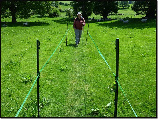
0711pond0712path1

It seemed a bit strange, but perhaps they have suffered from indiscriminate picnickers.  We gave them the benefit of doubt, though Andrew did complain that the path wasn’t wide enough for him!  (He hasn’t yet learnt how to comment on the blog, so can’t answer back!)

Further on, the path leading back to Alderley Edge has always been narrow, but unlike some Cheshire pathways, it’s protected from the farmer’s plough.

0714path3

We returned past the Engine Vein, pictured below, which a few years ago was an ugly open scar, where a line of early mining pits was excavated in around 1900.  After being fenced off, it now looks grassy and benign, hiding centuries of mineral excavation.

Numerous old tools, dating back as far as the Bronze Age (2500 to 800 BC) have been found hereabouts.  Many minerals are found here in the space of a few acres, including copper, lead, iron, zinc, silver, arsenic, silicon, barium, vanadium, and magnesium, in a variety of forms, mainly as thin films coating the pebbles and grains of the porous sandstone.  From the Engine Vein, later galleries and levels amounting to 22 miles in length, reach out beneath the Edge.

0717engineseam

There’s much more history to this place, but that’s enough for this instalment!

We were back at the car park soon after 2.30, after this most pleasant of bimbles – about 16 km (10 miles) with 250 metres of mainly unnoticed ascent, taking just over 4 hours.  Here’s the route:

0700route

Next – a 9 km evening walk on Tuesday (tomorrow) – meeting at 7.30 at the Information Centre near Delamere Station (SJ 546 703).  All are welcome.

Tuesday, 4 June 2013

Tuesday 4 June 2013 - Porthgain to Abercastle

Liz and Rachel had children to attend to at home, but the remaining eleven of us headed off to Porthgain in the school bus to complete this year's coast path adventure. 

The weather remained perfect - cloudless and warm. We didn't need to rush. Today we were to cover all of 8 km (5 miles) in two and a half hours, so time could be spent admiring the remains of the old brickworks and lime kilns, this being an area where much quarrying took place between 1840 and the 1930s.

There's also a bright white phallic tower on the headland beyond Porthgain, and further on, a stone circle at Aber Draw has the aura of a recent construction. 

Elevenses were taken beyond here, at the site of some ruined buildings. A seal swam along the coastline below us. A little further on, choughs were nesting in caves and crevices whilst a pair of Canada geese explored an inlet as if on their summer holiday. 

Fulmars and cormorants were also in evidence, amongst many other species, some of which have been referred to in earlier postings.

Today's cliff tops were swathed in bluebells as well as the usual Thrift, Sea Campion and Spring Squill. They were also adorned in places with a robust form of Red Clover and giant Foxgloves. 

Cattle were huddled into shady corners of their fields and all too soon we were huddled into a shady corner of Abercastle, waiting for the school bus. It was half an hour late; the driver got lost!

No matter, we enjoyed the moment before returning to Treleddyd-fawr and dispersing or staying on for more sun by the seaside. In our case the former - we dropped Andrew off in deepest Cheshire before getting home by 8 pm.

What a lovely trip. We'll try to upload a slide show before we head off again. 

Today's picture was taken on the final descent to Abercastle. 

Monday, 3 June 2013

Monday 3 June 2013 - Whitesands Bay to Porthgain

Well, not quite Whitesands Bay. We started from the cottage at Treleddyd-fawr and headed back along the lovely heathland path to rejoin the coast path at Penlledwen.

Another wonderfully sunny day saw us yet again admiring this route at its very best.

Out at St David's Head a homing pigeon befriended us.  Soon afterwards, after passing through orchid meadows, we came upon a tame kestrel. Nearby, after we'd passed through a corridor of tormentil, cowslips,  birds foot trefoil, primroses and bluebells, we watched as a gannet caught its lunch.  Spectacular.  A buzzard glided overhead whilst choughs and oystercatchers argued in the bay far below.  Black redstarts cackled at us from their viewpoints in the gorse. We failed however to spot any seals. 

Meanwhile, the burning sun blasted us from an azure sky. Much sun tan cream was required. Miss Application ruled ok - everyone has red bits.

A great black-backed gull toured the coast line. We watched through a haze of bluebells as it glided past the spectacular cliffs.

Lunch was taken near Aberdinas, then we eschewed Abereiddy in favour of Traeth Llyfn (pictured) where the two Sues and Liz enjoyed a swim.

The Shed at Porthgain provided a fitting end to the day by way of Cornish style cream teas for everyone. Then an old school bus appeared to deliver us back to Treleddyd-fawr, where we later reassembled for an evening of international cuisine and debate. 

What fun! About 18 km in not much less than 8 hours was today's impressive tally.

Sunday, 2 June 2013

Sunday 2 June 2013 - A Circuit from St David's

Another perfect summer's day found all thirteen of us back on the coast path from St Non's to Whitesands Bay (pictured).

We somehow managed to rendezvous at St Non's from our various lodgings, and once again we admired the artefacts and the stunning coastal views. 

Stonechats chatted in the gorse and jackdaws swooped and glided within the coastal inlets. A gannet floated uncertainly over the churning waters of Ramsey Sound and several parties of kayakers. 

Ox-eye Daisies dominated the verges of the path for a while, with Gorse and Thrift providing a panorama of yellow and pink. Heath Spotted Orchids and Common Star-of-Bethlehem had managed to colonise some damper areas.

Lunch was taken overlooking the Lifeboat Station at St Justinian. Swimming at Porthselau provided a diversion for Sue, Rachel, Liz and Sue, whilst the rest looked on as they shivered in the icy water. A more inclusive activity was the purchase of ice creams for most of the party from a kiosk at Whitesands Bay. Then we continued to Porthmelgan before heading up to Carn Han and on to the rented house at Treleddyd-fawr for tea and cake. 

The others stopped here, after 19 km in a good 8 hours, but while Andrew and Sue got a lift back to Y Gorlan, I explored some inland paths for another 6 km of late afternoon pleasure. They were little used and a trifle boggy, but very enjoyable. 

A quick turnaround saw us back at Treleddyd-fawr, this time for a barbecue and a convivial evening amongst friends. 

Saturday, 1 June 2013

Saturday 1 June 2013 - Newgale Sands to St David's

Having completed the South West Coast Path last year, Sue Emmett's ageing followers have this year tracked her to Pembroke, for a go at Wales. 

Today's walk was a complete contrast with last week's forlorn efforts around Fraserburgh. Perfect weather and footpaths have made for a wonderful day out in what must be 'World Class' scenery. Whatever words I now compose can't do justice to the quality of the landscape and its flora and fauna. 

After an interesting ride on an old school bus, especially commissioned by Sue E from the local transport museum to blend in with its passengers, thirteen of us set off from Newgale. Jacqui, Hilde and Anita immediately caused confusion by embarking in the wrong direction. Many years of "Keep the sea on your right" had perhaps ingrained to the extent that they were unable to adapt to the Welsh convention whereby the sea is on the left.

Eventually they realised their error and by the time elevenses was taken they had joined the rest of us - Sue, David, Sue, David, Betty, Liz, Rachel, Andrew, Gaynor and me. This was the last time we convened as a group today!

Sue and I soon fell behind. Flower photos were to blame. Sue continues to experiment with her new Canon G15 camera, and it takes time. 

The Gorse, as can be seen in today's image, is in fine fettle just now, with it's vivid yellow flowers. There are also large swathes of Thrift, Spring Squill, Sea Campion, Scabious and more. We watched Linnets and Stonechats forage in the gorse, and a Peregrine soared overhead for a while. 

Tea and cake outside a café overlooking the inlet at Solva was followed for Sue and me by lunch on a bench just above the village. People were jumping in off the quay. A family passed, carrying a kayak up the hill. "Extreme Kayaking" muttered dad.

We then caught up with some of the others and ambled along with them on the gorse bedded cliffs above the shimmering sea for the rest of the day. 

Before heading into St David's, some of us went down to the well and the chapel at St Non's. The well is said to have sprung up during a thunderstorm when St David was born around 500 AD. Its waters are alleged to cure infirmities. Anita tried to go for a swim, but it wasn't deep enough. The chapel is very small, with an exquisite stained glass window. 

Last night Sue, Andrew and I enjoyed nosh at the Farmers Arms before adjourning to meet the others at their de luxe residence a couple of miles away near the Youth Hostel. Tonight it's Bishops - just down the road from our B&B, Y Gorlan.

Just 19 km in 6.5 hours today. All very leisurely. Fabulous coastal scenery. 

Friday, 31 May 2013

Another Day, Another Trip

And where might we be tonight?  

Here's the view from our B&B.

(It can't be Scotland, of course, as it's not raining! )

Sent from 'abroad'

Thursday 30 May 2013 – Hail Storm Hill

3008sunset2

It was a lovely evening for this six mile exploration of Hail Storm Hill, just to the south of Waterfoot.

Sue and I set off from the otherwise deserted picnic spot at Waterfoot at 7.30 and after a false start through someone’s garden we headed relentlessly upwards, overtaking a couple of mountain bikers, past the gardens of Rake Head and onto Brandwood Moor.

3001Brandwood3002RooleyMoor

There is a single wind turbine on display as you rise to the south, but beyond the track junction, if you head towards that turbine, many more come into view.

Our mission to seek the summit of Hail Storm Hill took us first past Top of Leach’s trig point at 474 metres, which I’d visited before with Alan R and had a little difficulty persuading him that it wasn’t the highest point.

There’s a stone pillar here inscribed with the names of some of the local towns – Bacup, Whitworth, Rawtenstall, Haslingden and Rossendale, I think.

3003TopofLeach

The other direction, from a higher point, reveals the wind farm.

3004turbine

We walked to this other point that looked higher than Top of Leach, then through the shadow of the whirling blades and along the access track for a while, trying to minimise the amount of bog needing to be crossed to reach our target.  Just 800 metres of it from this direction.  Luckily it was fairly dry and no foot wetness was sustained.

Eventually we reached the summit – at 477 metres, the highest point in this area.  Marked by a massive cairn of about four stones.

3006HailStormHill3007sunset1

Heading north with good sunset views we passed through the mountain biking mecca of Cragg Quarry and soon regained the Pennine Bridleway, with good dusky views across Cowpe Reservoir to Bacup.

3009Cowpe

The Bridleway, which is also the Mary Towneley Loop at this point, took us nicely back to Waterfoot after just over two hours and a little more than 9 km with 276 metres ascent.  Our actual route and other data is shown below. (Click on ‘View details’ to do exactly that!)

An excellent venue for a summer’s evening stroll – a shame nobody else could join us…

Thursday, 30 May 2013

Tuesday 28 May 2013 – Around Rixton

2801cross

I took a bit of time out on Tuesday for a walk in the rain around Rixton.  I’d not been there before, although it’s just a few minutes away from Timperley, less than a mile beyond the Warburton Toll Bridge across the Manchester Ship Canal.

There’s plenty of space to park near The Cross at Hollins Green, and from The Cross you can head down a narrow path to the right of the cemetery.  This brings you out into the open fields pictured below.

2802tree

The footpaths around here are delightful, threading their way over streams and ditches and through fields that are lush with growing crops.

2803bridge

What a pleasant contrast to the pathless Aberdeenshire farmland that I could only observe from long tranches of tarmac last week.  Here in Cheshire, the lapwings seem as plentiful as they were further north, but I saw no oyster catchers today.

After crossing Dam Lane and enjoying more fields, I reached Moss Side Lane and turned right past the Brick Works.  The factory appeared to be thriving.

Rixton Brick Works

Beyond the factory, several entrances on the left draw one into the lush site (an SSSI) of Rixton Claypits.

2807claypitssign

Old pits, left after clay has been extracted for brick making, remain as a patchwork of woods, damp meadows and open water.  Orchids and yellow wort grow plentifully in the alkaline clay habitat.

2810claypits3

The abandoned clay workings that were last dug in the 1960s by Irlam Brickworks have enabled Rixton Claypits to become a Nature Reserve comprising lakes with islands, reedbeds and willow scrub, all rich in wildlife.  It’s a refuge for wildlife in an area dominated by light industry and agriculture.

2811bluebells

Huge numbers of plant and bird species can be found in the reserve, and at this time of year, as well as bluebells, the paths are lined by forget-me-nots and red campion.

2813claypits5

An information board, the support for which has been lovingly carved, explains that at least 18 species of damselfly (delicate – hold wings along their bodies when at rest) and dragonfly (larger – wings outstretched when resting) can be found hereabouts.  They are carnivorous, taking insects whilst on the wing.

2816sign3

There are loads of paths within the Reserve, and after a wander around them you can exit onto Manchester Road near a car park.  The paths follow the edge of the reserve, so the busy road is the other side of a hedge.

Returning to The Cross via Chapel Lane and School Lane, these buildings are passed.  They look a bit like mid European barns, but I think they are probably a legacy of the old brickworks.

2818farming

Here’s the route I took.  There are lots of footpaths hereabouts, so plenty of options.  It took me about an hour and a quarter for the 6 or so kilometres (4 miles).

2819map

Similarities to Aberdeenshire:

Damp hedgerows and empty paths….

Tuesday, 28 May 2013

Timperley

2701Canal

Sometimes it’s nice to be back home, beside a flower strewn canal towpath.

This picture was taken yesterday morning before the rain.  Which means that since then I’ve been quite happy to sit at home and plan the next trip, sort through a few photos and read a book.

Home can be a comparatively restful place.  It’s gone very green since I was last here.

Sunday, 26 May 2013

The Manchester 10km Run - A Great Success

26_103214_1fourrunners

Many readers will be aware that we were running today for the Levana School Partnership.  This posting is to thank those who have sponsored us, encourage those who haven’t to do so, and to report the results of our elite sub-team – pictured above.

We couldn’t really go wrong, as it was a perfect day for running, if a little warm.  I think we all wanted to come home inside an hour, and thankfully all four of us managed to achieve that aim.

For the record, our times were as follows:

Martin - 46.45
Mike - 50.38
Roger - 53.23
Sue - 58.27

There were just under 27,500 participants, of whom 12 managed to finish inside 30 minutes.  Presumably they had a clear run, whilst other runners presented our little team with some fairly solid obstacles.  I recall a rather large and ponderous Rubik’s Cube blocking my way for some time, for example.

Nell, pictured below second from left on the back row, has expressed her sincere thanks for all the donations.  She will be visiting the school in the next few weeks to check that all is well and that every penny is being spent wisely.

26_1022518runners

Thursday, 23 May 2013

Thursday 23 May 2013 -TGO Challenge Day 14 - Pennan Bay to Frazerburgh

Route: as planned apart from avoidance of some off road sections where I may not have been welcomed

See http:/www.topwalks.com/tgoc2013.html Day 14 for map

Distance: 20 km (Cum 370 km - 230 miles)

Ascent: 300 metres (Cum 10450)

Time taken: 3.9 hrs including 0.25 hrs stops

Weather: sunny periods, cold wind, seriously strong

Challengers encountered: 'Lilo' Pete Varley at the end (pictured); no other walkers were seen (as on most of the entire two week walk)

Total tally of Challengers seen since starting at Plockton:  5

We enjoyed Lilo's company last night. Unfortunately there was no room for him at the inn so he went off looking for B&Bs. The 'bad news', he reported, was that they were full. The good news: a passing dog walker had offered him a bed...

Research occurred.  Without wishing to cast aspersions on any of Pennan Bay's worthy residents, the chef kindly pointed dear Pete in the direction of a camping spot he had already sussed.

The bed at Pennan Bay Hotel was very comfy. This is the location where the film 'Local Hero' was shot.

I waited, after an excellent breakfast, until 9 o'clock for Lilo to turn up. He didn't. He had set off at 7.30 after a disturbed night. The strong wind had changed direction and become a gale.

Today the wind dominated. Even in the quiet country lanes every gust had the roar of an approaching juggernaut. 

It was a blustery endurance test to reach Frazerburgh. I chose to travel by roads. Down by the north coast eider ducks and seagulls bobbed on the waves. The smell of rotting seaweed and mouthfuls of sand were the reward for getting close to the sea.

Eventually, on the outskirts of Frazerburgh, Sue appeared and walked with me to the lighthouse museum. Reunited with Lilo, and pleased to be finished, we enjoyed tea and cake in the café before departing for Montrose for signing in and partying...

Sent from after the end of the TGO Challenge

Wednesday, 22 May 2013

Wednesday 22 May 2013 -TGO Challenge Day 13 - Turriff to Pennan Bay

Route: Not as planned. Adjusted to avoid off road sections where progress looked problematic, to minimise busy roads, and to add a pleasant off road section at the end

See http:/www.topwalks.com/tgoc2013.html Day 13 for map

Distance: 35 km (Cum 350)

Ascent: 650 metres (Cum 10150)

Time taken: 9.0 hrs including 1.5 hrs stops

Weather: bright, showery, bitterly cold, wind in face all day, full waterproofs to keep warm... are you getting the drift - not really very nice

Challengers encountered: none at the time of writing, and no non Challengers for that matter, except at the hotel. Lilo Pete is expected to appear at some point (late news - he arrived)

More of the same this morning.  But first an admission.  I failed to call in to Control on Monday.  Ian Shiel,  who as my vetter on several occasions has much experience of my incompetence, should perhaps have reminded me, but in the pleasure of the unexpected encounter with three people I knew, the phone call was never made. Sorry Control. 

Last night another conundrum concerned me.  'Lilo' Pete, the ballet dancing hairdresser, sent a message saying he was at Findhorn and would maybe see me at Pennan Bay tonight.  For those who know the local geography that's quite a hike. Anyway, he eventually faxed (or whatever you do these days) himself to Cullen, which seemed a more sensible and realistic location from which to start a day's walk to Pennan Bay. 

I noticed last night that after Wolfgang had so generously brought the sponsorship for the Levana School charity nicely up to its target, the target had been doubled. So further donations will be gratefully received!  (See 'charity' posting shortly before I set off on this walk, and a big thank you to all those who have already contributed.) 

Today:

A brief but intense shower ensured the tent went away wet.

I got going soon after 7am and before long I was enclosed in full waterproofs and, for the first time on this trip, thick gloves. There was an evil bitter wind.

The morning was spent walking to Gardenstown on the north coast. On the way I had dodged some off road sections that didn't look viable, and I managed to reduce the amount of busy roads. Lesser Celandine lined some of the verges, and the gorse seemed infested with flitting yellowhammers. At least they weren't flying backwards like the seagulls. 

Reaching the north coast (pictured) should have been a highlight. I had in mind a lengthy lunch in a nice pub or café. There was a small Spar shop. The place was deserted. Lunch was in a squall on a sheltered (but still windy) bench by the harbour wall.

The coast path to Crovie was brief but pleasant if you ignored the wind and rain. The sun appeared briefly.

My next objective was Troup Head to which a visit had been recommended by Roger B. Apparently there's an impressive gannet colony there. But the usual 'off road' problem thwarted me. Locked gates and barbed fences made it clear that visitors are not welcome. I'd been looking forward to a tramp along this north coast, but it's going to be a very limited one. 

Never mind, we are going to Pembroke next weekend.  Walkers are welcome on the stunning coast paths down there.

So I headed back in a big loop to join the B9031 road for the last lap of my tarmac trudge to Pennan Bay. I had plenty of time, and tiring quickly of the road I spotted an off road option that looked feasible, if extending my day by a good 4 km.

Suddenly I found myself on a nice earthen track, contouring through pretty gorse bushes Out Of The Wind. It was great. The walk up the Tore of Troup,  returning to the main road on the east side of the burn, has much to commend it. Especially as once I reached the main road I could cross straight over an stroll down to the Pennan Bay Hotel to check in and enjoy the best cuppa of the day. 

And this time I did remember to call Control, where Sue O and the team seemed in great form.

Sent from Pennan Bay with Sue and Pete and a pint of best

Tuesday, 21 May 2013

Tuesday 21 May 2013 -TGO Challenge Day 12 - Huntly to Turriff

Route: as planned plus via Turriff town centre

See http:/www.topwalks.com/tgoc2013.html Day 12 for map

Distance: 33 km (Cum 315)

Ascent: 460 metres (Cum 9500)

Time taken: 7.1 hrs including 0.75 hrs stops

Weather: varied from horrid rain to cold sunshine - 'all day gloves' and a bitter northern wind. Sheltered at camp though

Challengers encountered: none - just acknowledgements in passing from a variety of folk

You may be pleased to hear that there's not a lot to report today.

I paid my farewells to Ian, Alan and Fran and set off in unpleasant rain past scurrying tree creepers at 8am. I certainly felt better after failing to walk past the bakery, and even better when I found a viable if very muddy 'off road' section - and you had to be prepared to be friends with frisky bullocks.

After that the tarmac prevailed and the rest of the day was spent strolling along pleasant lanes in rolling Aberdeenshire farming and forestry country (pictured). If this had been in many other parts of the UK where the countryside is similar, there would have been a good choice of footpaths and ancient byways to follow. But here, any such thoroughfares have long since been tarmaced. The unsurfaced roads and paths that do exist generally lead to dead ends. 

A yellowhammer watched me for a while from a high wire, and a farmer informed me that I was 'a day behind'. He had seen three others pass this way yesterday. 

A glade of trees provided brief respite from the biting wind, to both myself and an even more weary David Brown 990.

I didn't stop much. The weather saw to that. So I found a tea shop in Turriff soon after 3pm. The cake was top notch.

The campsite is in a very sheltered position on the old railway line. I was even able to enjoy sitting outside for a while, but by 6pm I was forced to retreat to my tent to try to eat as much of my remaining food as possible as tomorrow a hotel has been booked. 

I've tried to find out how other bloggers are getting on, but apart from Gayle I can't seem to spot anyone who is making postings. I'm sure there must be lots out there, or is everyone else twittering? That's what those youngsters I met, Iain and Simon, were doing. 

Wow - I may have time to turn on my Kindle for the first time tonight! 

Sent from Turriff campsite