The main purpose of this blog is to keep in touch with friends and family, and maybe entertain others with common interests, particularly in relation to the outdoors. We hope you enjoy it, and your comments are valued....
Sue and Martin in Mallorca 2019
On the Archduke's Path in Mallorca
Thursday, 15 May 2014
Carn na Caim
Wednesday 14 May 2014 - TGO Challenge - Day 6 - Lochan na h-Earba to Dalwhinnie (for Newtonmore)
After a slightly disturbed night due to sleep not being on the agenda of the local bird population, especially one that made a frequent curlew like trilling sound, I woke to high cloud and a windless 6C.
The glassy lochan reflected a lovely skyscape.
Having decided to ease my day by omitting the aforementioned hills - they will form the basis of an excellent day walk sometime - I spent the first few hours strolling along pleasant lochanside then forestry tracks. Geese, dippers, curlew, various other birds, and distant red deer were my only company. The first human encounters of the day were Peter and Barbara, in Dalwhinnie, on their way to the distillery.
Geal Charn was sunlit in weather that again demanded t-shirt and suntan cream. It's pictured as the backdrop to my elevenses break.
Disconcerting forestry signs requiring authorisation for entry to a small area of deserted woodland were summarily defaced.
By late morning I'd reached Lochan na Doire-uaine, a small lochan edged by a fossilised forest. This led to a rocky defile that Markus and I had negotiated a few years ago during his fine Caledonian Trail walk. It was as I remembered. A bouldery mess with deep holes and no evident path. A vetter has apparently described it as an area slashed by the lashing of a dragon's tail. It looked to me like the 'other worldly' set from a dinosaur movie. There were traces of boot prints - probably belonging to Peter and Barbara.
Once through the defile, a small river appeared, the path slowly regained its composure, and I could enjoy a second lunch (my provisions inexplicably contained two tins of fish today) in the knowledge that I would be in time for the 16.09 bus to Newtonmore.
On the way I called in at the café for coffee and cake, and met Markus and Philipp who joined me on what turned out to be a private bus ride to Newtonmore, where we are TGO Challenge 'tourists', staying at Sue and Ali's bunkhouse.
There are too many to mention here and at Dalwhinnie, but my plan for a sociable Challenge has certainly been achieved.
In particular it was good to see Louise and Laura in good spirits, the Forfar trio, Sam and Richard, Emma, Peter and Jayme, to name but a few, not forgetting Ali, Sue (en route to Montrose) and Neil at the bunkhouse.
Wednesday, 14 May 2014
Tuesday 13 May 2014 - TGO Challenge - Day 5 - Annat to Lochan na h-Earba
Sun blazed down on the tent. It was 6am. Time to review my surroundings without it tipping down with rain. The bright red tent 100 metres away must be Stefan's. He soon appears. All muscles and underwear. He set off from Spean Bridge at 5pm last night to join the International Gathering that others missed. Arriving at midnight, Stefan was also on the tardy side. I shouldn't complain - I'd completely forgotten his commitment.
We spent a while catching up, before Stefan adjourned to prepare a lavish breakfast of black pudding, white pudding, sausage and pitta bread, with a pot of fresh coffee nearby. I expect he also had a carton of eggs! This may be the German's last Challenge for a while - he recently married his childhood sweetheart and they are expecting a mini Stefan. Congratulations to all concerned.
It has been a lovely day. One of the best Challenge days I can remember. I saw no other Challengers (tomorrow will be different) but there were a few folk on Creag Meagaidh and several walkers and mountain bikers on the track up to the lochan I'm camped beside.
The route up Creag Meagaidh from Annat (Turret Bridge) is long but very well graded. It was a delight in today's benign conditions. I took my time. Vistas of snow dappled mountains opened up in all directions. A pair of amorous ptarmigan completely ignored me. I dumped my sack and popped up Stob Poite Coire Ardair. Sod's law dictated that my camera battery expired during this excursion, so some opportunities were lost before I could return to the sack for a spare. No doubt Sue and I recorded similar scenes when we walked the entire ridge during the 2009 Challenge.
Up on Creag Meagaidh, Jim and Davy were celebrating Jim's hundredth Munro. Well done Jim!
The descent started gently, past the spot where Liz's gloves flew away a few years ago. It wasn't so windy today. My lack of research let me down once I reached a point below 700 metres where the substantial wall I was following turned right. I headed on down over pathless rough terrain with rock bands. There must be a Munroist's path somewhere but I didn't find it. So it was a tired man that ambled up the track to Lochan na h-Earba, and a relieved one who found a spring nearby and a brilliant camping spot at the end of the lochan.
Today's picture is from the ascent of Creag Meagaidh just above The Window. My attempts to photograph a flock of plovers (I think) and small mushrooms and butterflies were less successful.
Tuesday, 13 May 2014
A Sunny Morning
Monday 12 May 2014 - TGO Challenge - Day 4 - Gairlochy (Torness) to Annat
After bidding the Forfar trio farewell at the midge infested campsite, I saw just one person all day. That was Sam Hackett, in his tent at Turret Bridge, during the short break between the first shower and the continuous rain that arrived about a minute before I got the tent up. Having been both taken down and put up in rain, the Solar Competition 2 is just a little damp around the edges. It's pictured in the rain in this excellent sheltered spot by a chattering stream. In fact the stream is so talkative that I keep thinking people are walking past.
Sunday, 11 May 2014
Sunday 11 May 2014 - TGO Challenge - Day 3 - Sgurr Mhurlagain to Torness (Gairlochy campsite)
I forgot to mention that yesterday's picture was of the snow on the north side of Sgurr Mhurlagain. That hill isn't much higher than 850 metres, so the snow to the north of higher summits may be impressive.
Today's image is of Loch Arkaig, with Sam Hackett, during our elevenses break.
Having made the decision to descend from my misty but comfy camp, I treated myself to a lie in whilst the rain continued where it had left off when I went to sleep last night in the wet cloud in which I was still immersed.
I'd just converted an excruciatingly tough day into a very easy one.
It took an hour over easy ground, soon descending below the cloud base and disturbing numerous deer, to reach the quiet single track road that undulates alongside the north shore of Loch Arkaig. It proved quite pleasant to walk along after yesterday's roughness, and Sam was good company after he caught up with me, as were a trio from Telford - Alan, Anne and Nigel. I hope that those three reached Fort William in time for tea.
The tree lined loch was very pretty. This year the trees are more advanced than usual and are rich with foliage in all shades of green. As Sam and I enjoyed our half hour break, woodpeckers entertained us from above.
We reached the Clan Cameron museum at one o'clock after enduring the 'shower of the day' for about an hour. The museum opens from 1.30 to 4.30. So we took advantage of the large picnic bench outside and brewed up in comfort. The Telford trio were dining on Mountain House dried meals. They looked disgusting. "They are disgusting" quipped Nigel as he headed to the garden to use his as fertiliser.
We drifted off, one by one, after ice creams and an hour on the bench in the sunshine, having reverted to t-shirt attire.
The Great Glen Way was soon joined - a delightful woodland path skirting the western end of Loch Lochy. Great views down the loch that Sue will remember from 2009. Wood Sorrel and Wood Anemone line the path at this time of year, together with violets, bluebells and all the usual spring delights of these parts. There's also a concrete landing craft structure that was used for training purposes in WW2, and even one or two wrecks.
At Gairlochy lochs a surprise awaited. Apart from Sue and Chris Marshall, Markus and Philipp, the two Austrians, were there to greet me. I walked up to the campsite with them. Markus is just about coping with carrying Philipp's two kilo tripod, which has yet to be used.
It was something of another surprise to find Mike Gillespie and his two cohorts, Pat and Alan, on the site. I should have quipped "have you spent the past five years here?" but I didn't think fast enough. Is it really that long since Sue and I met Mike's team at this very spot?
We are a select band of four Challengers staying here tonight. Thanks for the company folks, albeit somewhat disrupted by midges then rain. And thanks for opening my can of strawberries - they were delicious with the chocolate custard!
A call to Alvar at Challenge control confirmed the rumour that Tim Wood had dropped out at Mallaig before starting. It's just not the same for him without Kate. I'm sure everyone who knows Tim will wish him and Marjorie well.
Alvar didn't mention any other problems, but then I received two messages. One from Markus to say they had chosen an easier route to Dalwhinnie so would not be seeing me tomorrow as planned. That's fine, I'm so glad they let me know. Also a message from Heather T-S who had been involved in an evacuation of a non Challenger to Glenfinnan this afternoon, when a bed and a food parcel was waiting for her in Spean Bridge. What bad luck - I do hope she's able to continue.
Saturday 10 May 2014 - TGO Challenge - Day 2 - Sgurr nam Meirleach to Sgurr Mhurlagain
A tough day over very rough ground. Began at 7.30 in mist and rain. It was a shame that the views from the summit of Bidean a'Chabhair (it's the one that looks like Sgurr na Ciche as you walk up Glen Dessarry) were somewhat limited. Care was needed. It was nearly 11 o'clock by the time I reached the Glendessarry path. There were numerous Challengers here - apparently there were over twenty tents in the vicinity of Sourlies bothy last night.
I bumped into a group from Macclesfield doing the Cape Wrath trail, then Jeremy arrived from Finiskaig having descended to the north rather than carry on along the ridge. Jayme and Peter may have done the same - I didn't see them today.
After discussing the Pyrenees with a couple from Sydney - these things just seem to happen - we continued along the boggy but not as bad as usual path to Glendessarry, by which time it had stopped raining and we could enjoy a leisurely hour for lunch.
Jeremy headed off to Kinbreack and I continued down the firm track with Ian and others. We met a Challenger coming up the track - "you're going the wrong way" we jested. "I'm not" he countered, hastily consulting his map. "Oops" he concluded.
I soon left the main drag to climb Sgurr Mhurlagain and bumped into Jim Taylor, resting on his way over to Kinbreack. "You know I'm ninety one" he enthused, during our long chat.
The sun illuminated the ascent, and it was t-shirt weather all the way, with great views. However, I could see lots of rain coming in, and it was quite late (for me), so I headed down to a likely looking stream and managed to set up camp just before the rain started. Four hours later it's still going strong and there's a red deer outside that seems to want to join me in my dry and cosy home. She's out of luck.
Saturday, 10 May 2014
Friday 9 May 2014 - TGO Challenge - Day 1 - Morar to Sgurr nam Meirleach
The day started with a quick breakfast in the presence of Jim Taylor, a 91 year old Challenger. I hope he makes it. Then I made my way to the 8 am bus. The driver kindly made arrangements for me to change buses at Arisaig so that I could be delivered to the entrance of Johnny and Val's campsite at Camusdarach.
A coffee there went down well. Jeremy Prall, a first timer from Sedbergh, turned up and stayed for a bacon butty whilst I signed out and started walking at 9.10.
A path to the beach saw me diverting from my Anquet blue line and splashing in Atlantic surf before heading on past some interesting architecture to Morar.
Jayme and Peter were strolling along. I joined them for the rest of the day. Heather and David joined us for the latter stages after we'd inadvertently overtaken them.
We found Jeremy later, not far from where I am now camped. He has a prime spot by a small lochan. J and P joined him there, whilst I moved to the other side of the hill to avoid Peter's snoring. H and D have carried on a little further, but 10.5 hours on the first day is quite enough for me, and I only just had time to finish my meal before darkness fell.
Friday, 9 May 2014
Lochailort to Morar
Thursday, 8 May 2014
Montrose to Lochailort
Wednesday, 7 May 2014
Bridge of Gaur to Montrose, not via The Hill of the Soggy Raspberry
Newtonmore to Bridge of Gaur
Tuesday, 6 May 2014
Ladykirk to Newtonmore
Monday, 5 May 2014
A Re-supply Service
Sunday, 4 May 2014
Another TGO Challenge Awaits
Today I will set off with a car full of re-supply parcels destined to be dropped off at various points on a rather wiggly route to Montrose, where I’ll park the car and get a train to Morar, taking 14 days to walk back to Montrose by a ‘low level’ (ie less than 12 Munros and Corbetts) route, starting next Friday.
That’s the plan, anyway. I’ll be posting brief entries along the way, which is shown roughly, together with my kit list, on this web page.
The esteemed route vetter who is shown above demonstrating a river crossing technique on last year’s Challenge, will be seen by many of us on this year’s event, hopefully proffering a tray of cakes…
And just before I go, some good news. Our swifts have made it back to their nest by this study window – I can hear them sorting out their belongings after having arrived overnight.
Meanwhile, Sue is sunning herself in Turkey on the Lycian Way – have fun Sue…
Saturday, 3 May 2014
Thursday 1 May 2014 – An Evening Walk around Goostrey
The long evenings and daylight walks until late have soon come around.
On Thursday a select little group met in the quirky pub near Goostrey station.
Sculptures adorn the car park.
As do some vintage cars. The Ford Anglia is nearly fifty years old.
After a delightful stroll through The Bongs, we wound our way past several farms to a spot where Andrew expounded on a new permissive path that loops through fields and bluebell woods.
The good people of Goostrey are very progressive, and have created this excellent new footpath. Here it passes through a field, but it’s mostly in woodland. Very smart stiles and sturdy signs are evidence of the planned permanence of the path.
Having started at 7.45pm, by 9.30 it was getting dark, but these longhorn cattle seemed quite happy to stand and stare, though the males seemed intent on locking horns with each other.
The bluebell woods on this walk were extensive and stunning. Well worth a visit when there’s a bit more light to illuminate them, but very pleasant even at this time of day.
Here’s the route we took, before and after beers at the Red Lion.
8 km, minimal ascent, allow 2 hours.
Happy Days!
Friday, 2 May 2014
Monday 28 April 2014 – The Mary Towneley Loop
Robert and I failed to complete this 75 km (47 mile) bike ride when we tried on 22 June 2012. The report is here.
This time we had near perfect weather and pretty dry surfaces. Mike was busy launching a new website, but Paul joined us to make up another trio.
We took our time, especially after setting off 45 minutes later than planned due to Robert’s carelessness with traffic.
So it was a cheerful Paul, Robert and Martin who set off at 9.15am, from the picnic car park at Waterfoot.
Here’s a map that I’ve gleaned from elsewhere, and thanks go to one John B Taylor for producing it. The route is basically a classic circuit of bridleways in the South Pennines area. It’s hilly – constantly undulating with 2000 metres or so total ascent. (My mapping software says 2350 metres, but my Garmin GPS says just 1820 metres.)
It took us an hour and a quarter, including a slight navigational mishap, to reach the memorial to Lady Towneley, who inspired the development of this bridleway route. I haven’t time today to go into its history, but there is lots of information, and reports of much quicker trips than ours, on the web if anyone is interested.
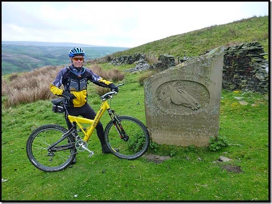
After two and a half hours we reached Can Clough Reservoir, with the weather great and the bikes all running smoothly. (If in my case rather slowly!)
A perfect day for a bike ride
Here are Paul and Robert on Black Moor, beyond Hurstwood Reservoir, with the upper Gorple Reservoir to their right.
We passed countless reservoirs on the 75 km ride.
Much of the route is very rough, and steep - this image is deceptive until you notice that Robert has had to dismount.
After four and a half hours we'd had lunch and were enjoying views towards Hebden Bridge before an excitingly steep descent to Charlestown.
Here we enjoyed our first crossing of the Rochdale Canal, after five hours on the bikes.
It's a long haul back up to the Mankinholes track. "Glad we don't have to go up to Stoodley Pike" we agreed.
There were many paths with differing qualities of cobbles, this one by Lumbutts, beyond where the cobbles stretched for miles.
At Bottomley, after nearly seven hours, we took a welcome break at our second crossing of the Rochdale Canal. Then the bridleway undulated more disconcertingly than ever, with some steep sections that even had Paul and Robert pushing.
Finally, we hauled ourselves up the last and very long ascent, up Rooley Moor to the highest point of the day.
Soon we came across this welcome sign - just 3 miles to go - by now we'd been on the bikes for over ten hours. The others had just returned from cycling holidays in Mallorca, but I hadn’t been out very much. My bottom was sore.
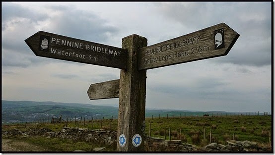
Those last three miles stretch off into the distance beside Cowpe Moss, with Robert and Paul just distant specks. Very pleasant cycling though, and we knew we were nearly home.
We completed the 75 km route in a little less than 11 hours, just before darkness fell. A fine day out. A local hostelry was deemed to be essential from a life-saving point of view, but after finishing the ride at around 8pm Paul and I weren’t home until well after 9 o’clock. Thanks go to Sue (and I imagine Jeanette) for having much needed food on the table more or less instantly.
The day really warrants a fuller report, but I’m afraid time has got the better of me. I’ll add any further comments/corrections that Paul or Robert would like to make.
Here’s a short slideshow with a few more pictures.
And here’s what my Garmin recorded – note that it has smoothed off some of the corners and the time of about 8 hours is ‘moving’ time. We took nearly 11 hours in total.
PS Robert informs me that one of his tyres expired on his way home. We were fortunate that it did this in his car and not during the ride!
Thursday, 1 May 2014
Sunday 27 April 2014 – A Lamaload Bimble
Sue W kindly organised this stroll in the Peak District. After assembling at Lamaload Reservoir at 10.15, 17 of us set off in the direction of Rainow on what Sue had advertised as an ‘11 mile bimble’.
Soon faced with serious route-finding decisions, we elected to go This Way.
It was a fine, sunny, April day as we admired the view north towards Rainow.
Arriving at the Gritstone Trail path that leads to the Saddle of Kerridge, with White Nancy already visible, we immediately diverted from it to ascend the steep side of Kerridge Hill to a trig point that some members of the party wanted to ‘bag’. (A point that regular readers may recognise from numerous previous visits.)
Time for a group photo – see above.
After only 4 km, an elevenses break was taken before we headed to the end of the Saddle, where White Nancy, a folly built around 1817 to commemorate victory at Waterloo, overlooks the old mill town of Bollington.
We descended quickly down the steep slope before heading east, now firmly on the Gritstone Trail for a few miles, with fine views of trees coming into leaf...
... and the bluebell woods near Berristall Hall.
Soon after passing a sheep with a very newborn lamb, a shouting guinea fowl, and three docile ducks, Sue W urged "Come on you lot, it's eleven miles", the first sign of anxiety over the time we would finish.
"I'm stopping for lunch" announced Colin, two minutes later.
Soon afterwards, we left the Gritstone Trail for good and took a diversion up an extra hill from Charles Head, thanks to a new permissive footpath that led to a short ridge with good views to Shining Tor, with Shutlingsloe just visible. We were careful not to disturb ground nesting birds like the snipe I nearly trod on.
From the ridge it was a sharp descent to Summer Close.
I'd expected to head straight to Shining Tor, but Sue W's 11 mile route took us away to the north east and Taxal Edge, where we lazed for a while at Windgather Rocks.
It's a pleasant stroll along Taxal Edge, above the Goyt Valley. Luckily Keith was making good progress after his illness, so he could just about manage 11 miles.
We rested at length above the Cat & Fiddle road at Shining Tor, the highest point in the area at 559 metres. "Is this bimble really 11 miles?" asked Graeme "... it seems like more…?"
Soon we were off and away on the last lap over Andrew's Edge, where Andrew wasn't waiting for us, and down to Lamaload in the afternoon sunshine.
Lamaload Reservoir, reached soon after 5pm, was glinting in the early evening light.
Here’s our route - 25 km with 750 metres ascent in 7 hours. "An excellent 11 mile bimble", announced Sue W. Nobody disagreed apart from a slight debate about the distance.
Then we all went home for tea. Thanks for organising, Sue, and it is indeed a most pleasant route. Visitors from Greater Manchester may find it more convenient to start from the Middlewood Way car park in Bollington.
There’s a slideshow (36 images) here.