Wednesday 15 April: I received this message:
Martin,
Are you planning on doing the Calderdale Hike on Saturday? I am planning a slow walk round.
Robert
Rob and I go back a long way - to UMIST days and our joint role as stalwarts of the Hiking Club's team for the Bogle Stroll. After the demise of our interest in that walk we gravitated to an annual workout in the much prettier countryside of Calderdale (the Bogle Stroll was an overnight road walk based on the A6 road). The Calderdale Hike has the added advantage, for old timers like ourselves, of being only half the distance of our previous annual workout.
I had been totally unaware that the hike was on, having missed it for the last few years. Somewhat surprisingly, I was free, and turned up to enrol at the start with about 250 like-minded souls who were walking or running either the 36 mile or the 27 mile course. Rob and I chose the latter, and being over 50 years old I enrolled as a 'Veteran Walker'. Rob still has a few years to go in the 'Man' category.
On Friday I had glanced at the map and visualised a route between the twelve checkpoints. There were lots of alternatives - part of the challenge is to navigate your way between the checkpoints, and the course changes every year. Walkers are not allowed to run. My Inov-8 Roclites that wore out after 291 kilometres had been intended for this sort of walk, but with that sort of performance I won't be going near Inov-8 again, so today, for this brisk stroll, I donned the Nike trainers given to me by Nick at Christmas, together with some trusty old '1000 mile' socks.
Our kit was checked and off we set at 8 am from Sowerby Bridge Cricket Club.

Beyond the Church Stile Inn, so welcoming back in October but now clearly a victim of the credit crunch...

...there's a quick way to the first checkpoint at Brearley Bridge - you go straight down the road to join the Rochdale Canal at Luddendenfoot. Everyone else went that way.
It's much more scenic, if longer, to drop from Sowerby straight down to the canal, so that's what Rob and I did.

Very pretty it was too.

We found ourselves totally alone on the canal towpath on a glorious morning.

It had started clear and cool, with gloves for me, but the 370 metre ascent out of Mytholmroyd to the checkpoint at Crow Hill Nook was abrupt and sweaty, leaving salt on parts of my body I would later regret. We had ascended more quickly than most, and continued amongst the vanguard that chose a variety of routes to get to the vicinity of High Brown Knoll, from which a steep descent led to the next checkpoint at Keighley Road. We chose 'The Tussock Way', having missed the proper path.

One 'walker' could be seen far ahead, jogging down beyond the trig point at High Brown Knoll. Rob knew that it was Philip Whitaker, who had shot off from the start and had won the Veteran Walker class last year.
[It is apparent that both he and Jan Hill, the fastest 'Lady Walker', regard jogging downhill as 'walking'. "You just have to jog down the hills, don't you?" said Jan, as she later caught us up near the finish. Hmmm.]
Anyway, secure in the knowledge that the veteran walkers trophy would go to Philip, and knowing that Rob was not too fussed about regaining the huge 'Fastest Man' trophy that he won last year...

...we continued just inside the timings that I'd calculated to be brisk but not excessively knackering. We had been joined by Luke, a gap year student, who had shot ahead of his mates and wasn't inclined to get his map out. We were happy to chat to him and show him our way.
By the time we reached Keighley Road, the fastest runners, who had set off an hour later than us, flew past - they were going nearly twice our pace. Here they are...

...and there they go...

There were some narrow downhill sections where we were baulked by some slow walkers who must have known a better route across the moors. "Runners coming!" we shouted, and they moved to one side, but not for long enough for us to slip past as well. Ah well, we were in no great hurry.
We breezed over Shackleton Moor to our next checkpoint at Walshaw Hamlet. There were loads of runners about, some fairly distinctive. The checkpoint was very busy. These points vary from an individual in a car, to a large gazebo with a selection of drinks and foods. A good feature of the organisation is the requirement to take a mug, thereby eliminating the potential blight of plastic cups being strewn around after each checkpoint. Here we enjoyed sandwiches, bananas and chocolate biscuits.
It was a wonderful day for a walk, warm in the valleys and cool enough high up to dry off any sweat without actually feeling cold.
The 36 mile runners headed off towards Widdop Reservoir, whilst those of us on the short course ambled off to Clough Hole Bridge. We had to amble; those people who go down hills very slowly and don't let you go past had rushed through the checkpoint and got ahead of us. Anyway, the climb up from Hebden Water soon disposed of them, leaving Rob, Luke and me back in our own private world. We passed a dead lamb on the sunken path. There were fewer runners around, and care was needed with navigation as whilst some folk had recced the route and knew all the short cuts, others were bimbling aimlessly but quickly enough to give an incorrect impression of knowing where they are. It's inadvisable to follow such folk, so it's important to pause occasionally and micro-navigate - walking quickly it's easy (for me, anyway) to lose track of where you are!
From Clough Hole Bridge we nipped up to the Pennine Way then relaxed briefly in some country lanes before heading over Staups Moor to the next checkpoint at well-named Great Rock, with views to Stoodley Pike Monument, just 2½ km away as the crow flies, but another 13 km along our designated route.

Here the support was basic but effective,

and as always there were jolly volunteers to clip our cards and record our numbers.

The next section along the scenic paths of the Calderdale Way was easy enough as far as Hole Bottom. By now Luke was finding it hard to keep up. He was relieved at our decision to descend directly to Todmorden to cross under the railway at an obvious spot and emerge onto the main A646 road opposite the cricket pitch. From here, instead of following marked paths we turned right and headed into a large park, beyond which a steep wooded bank led, pathless but direct, to a road across which a track led on up to Todmorden Edge.
We were over half way now, and as Rob and I hauled ourselves up the steep bank we heard a breathless cry from behind:
"I need to stop, guys, which way to the checkpoint?"
Luke was starting to cramp up. We waited for him to reach the tall mossy wall from which our 'directissima' route involved a jump down to the road below, and left him sitting on the wall with directions as to how to reach the Todmorden Edge checkpoint. After that he would be on his own, and without the assistance of others he may even need to expose his map!
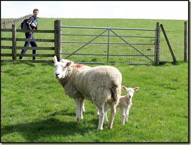
Todmorden Edge represented the western tip of our route. From here we turned abruptly east towards the beckoning monument on Stoodley Pike, some 5 km distant. The direct route leads down a road and back to Todmorden, but being in no particular hurry we ambled on along the Calderdale Way, on a jinky little route past some worried sheep
to Lumbutts, where the hike's most impressive support point was located in the foyer of the church. Sustenance was needed here, as beyond this point is the 220 metre haul up to the Pennine Way and the path north to Stoodley Pike Monument.

We made good time on this beautiful day and here we encountered some of the 36 mile runners who had passed us before Walshaw Hamlet. So they had continued to speed along at almost twice our meandering pace.
It was quite busy from now on, with 36 mile runners passing, and a few 27 mile runners catching us up but really only moving at our walking speed, which remained constant throughout the day. The cool breeze on Stoodley Pike was supplanted by a warm, sweaty descent to Withens Clough Reservoir. It was here that the accumulation of salty deposits became a little annoying...my small appendages becoming somewhat tender.
'Walker's Nipple'?
We thought the next section would be easy enough - down the lane to Cragg Vale then along the Calderdale Way to High Stones Hill. Unfortunately, down in Cragg Vale, whilst we paused to admire some pretty piglets,

Jan Hill jogged up. "I'll follow you" she said, "but it's not up there" (she pointed to the poorly marked Calderdale Way path) "it's up the road then up some steps." So up the road we plodded, against our better judgement, but Jan knows the area and had done a recce. Her route, for which she was admittedly very apologetic, took us on a dogleg into a disgracefully maintained farm (dodging the slurry in our trainers was quite an achievement) from which we eventually extracted ourselves onto the correct path. Thanks, Jan!
Some very pleasant paths then saw us romping along to the final checkpoint at Shaw's Lane,

then it was an easy half hour's road walk back to the finishing point at the Cricket Club. Jan fell back and made conversation with one of the runners who was struggling a little. I think our comments about not having run at all shamed her into holding back from running past us, and she certainly wasn't able to walk past.
Anyway, it was a lovely afternoon, and we all finished at around
3.35 pm, to applause from the assembled masses outside the Cricket Club. These 'masses' were runners who had finished, and various hangers on enjoying the sunny afternoon. We were in fine form, our trainers having proved ideal footwear, and unlike many others we had kept our feet dry.
For a small entrance fee we had enjoyed loads of support (food and drink) during the day, and now we could enjoy the mugs of tea and excellent baked potatoes and chilli, etc, etc, laid on in the clubhouse. More alcoholic rehydration fluid was also savoured, and Rob and I joined in the applause as Jan was awarded her 'Fastest Woman' trophy, recycled from an era when a much longer event was held over the entire Calderdale Way - that was discontinued many years ago because of the difficulty in marshalling checkpoints for 24 hour periods.

Rob enquired as to whether he had retained his 'Fastest Man' trophy.
"No, this year Philip entered as a man, not a Veteran, so you were second" was the reply.
So, most surprisingly, ten years after first collecting it, I am again privileged to be the proud possessor of the Heggers Trophy for the fastest veteran walker, which this year was accompanied by a bunch of bananas!

The trophy is carved out of wood from a loch gate on the Rochdale Canal, in memory of Tony Heginbotton (1947-1997):
"A staunch supporter of the Calderdale Hike
He walked the valleys, hills and moors
In all kinds of weather
With all kinds of people
And in all kinds of footwear
He enhanced every-ones life who he came into contact with."
It's rather more battered than when I last had it, but its maker doesn't want to refurbish it as "The damage is of historic significance as it was incurred in The Great Yorkshire Earthquake of a Couple of Years Ago"!

I think we must have been abroad.
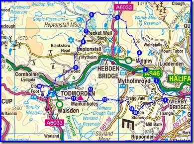
Here's today's route outline - 43 km with 1730 metres ascent in a shade over 7½ hours. A good workout, as expected, and a chance to catch up with Rob - thanks for letting me know about it, Rob.
PS Leaving the Cricket Club a good hour after finishing the walk, we were pleased to see that our erstwhile friend Luke had just finished. He was exhausted, and glad he'd not tried to keep up for any longer!


