Here are Martin and Bill enjoying the views from its rim.

We spotted a desert lizard:

And drove back to Maadi through the outskirts of Cairo.
 To enjoy refreshments on the roof of Bill and Alison's spacious apartment.

We spotted a desert lizard:
And drove back to Maadi through the outskirts of Cairo.
To enjoy refreshments on the roof of Bill and Alison's spacious apartment.
 Sue meets a 'local' outside the Step Pyramid
 We thoroughly enjoyed our day here, which included a visit to the Imhotep Museum, and some interesting roads to the Dahshur Pyramids - the Red Pyramid and the Bent Pyramid (pictured below).
 Bill was the ideal host, and Sarah an excellent companion for Sue and me.
 Our genial host is now about to whisk us off to a party, so that's all for now...
In the company of a man with his beard tucked around his ears, we shuttled off from Manchester's T3 to reach this brand new emporium - T5 at Heathrow.
The flight to Cairo was my first in a 747 (Jumbo) - it was delayed for an hour whilst two cats were removed from the hold because the heating had broken.
The wide luminous ribbon of the M25 belied the fact of a grey day in the UK. We were pleased not to have even thought about packing waterproofs for this 10 day trip - undertaken on the pretence of attending Selwa and Amro's wedding in Alexandria.
It was clear over the Alps, but after a spattering of lights as we passed over the Inn Valley, there wasn't much sign of life in the mountains.
The sparsely lit Adriatic coast was followed by a series of spindly roads leading to Athens, and then we were over Cairo, at midnight. Thursday night is their equivalent of Friday, and the huge city looked very busy below us.
BP's welcoming system efficiently 'immigrated' us, and with our 'hand luggage only' policy for this trip we soon sped through to a waiting car and the journey to Maadi, an affluent suburb to the south of Cairo, where Bill and Alison rent a spacious villa. It was 1.30 am, but Bill was up to greet us and show us around before we finally flaked out in the luxurious surroundings.
 View of the Wye Valley from Monsal Viaduct
Mark (Beating the Bounds) comments:
"Ruskin allegedly said that the view of the Lune valley from the churchyard in Kirkby Lonsdale was the finest in the world, but had he been to Monsal Head?"
I'm afraid he had been to Monsal Head, Mark. And he thought very highly of it. Until the railway came. This is what he said:
"You think it a great triumph to make the sun draw brown landscapes for you. That was also a discovery, and some day may be needful. But the sun had drawn landscapes before for you, not in brown but in green and blue and all imaginable colours, here in England. Not one of you ever looked at them, not one of you cares for the loss of them when you have shut the sun out with smoke so that he can draw nothing more, except brown blots through a hole in a box. There was a rocky valley between Buxton and Bakewell, once upon a time as divine as the Vale of Tempe; you might have seen the Gods there morning and evening - Apollo and all the sweet muses of the light - walking in fair procession on the lawns of it, and to and fro among the pinnacles of its crags. You cared neither for Gods nor cash (which you did not know the way to get) you thought you could get it by what the Times calls 'Railway Enterprise'. You enterprised a railroad through the valley - you blasted its rocks away, heaped thousands of tons of shale into its lovely stream. The valley is gone and the Gods with it, and now every fool in Buxton can be at Bakewell in half an hour and every fool in Bakewell at Buxton; which you think a lucrative process of exchange - you fools everywhere."
I'm glad I photographed that information board! I enjoyed transcribing it. There's food for thought, perhaps, with some present day analogies. It has to be said that time has largely healed the scars of the railroad, apart from the impressive viaduct.
Our next series of postings will be a mixture of 'Blackberries' and remote computer transmissions when we have access to them, so there won't be many images for ten days or so. But there will be a new 'label', and perhaps, temporarily, a few different readers / viewers. So we welcome any newcomers and hope we will be able to transmit on the 'big day' (Monday).
Before we go, we would wish Phil at Doodlecat our very best wishes and hope his imminent traumatic experience will cure his ailment, and we wish all those in the TGO Challenge hat at the weekend every success in being pulled out of that hat. We are also conscious of a number of other people who are currently hampered by health and other issues, and we wish you well. Finally, we trust Gayle and Mick will make it safely to Fort William - well done in anticipation.
 Having got my new boots, a short stroll from Monsal Head to break them in was in order. The view above greeted me.
Turning left down the Monsal Dale path, I soon reached the weir - a roaring torrent - no paddling across here today. Then over the narrow bridge and into the autumn sun, where leaves, like these Norway Maple (?) in Little Longstone, were nicely illuminated. 
Back up in Little Longstone, this 'phone box and the village pump next to it had also caught my eye.
The path follows the right (north) bank of the River Wye and rises to the Monsal Viaduct, from where the disused railway line disappears into a tunnel. A short climb leads back to Monsal Head, and the Hotel, which I took the opportunity to book for a Christmas Walk lunch on 14 December, to which everyone is hereby invited.
A slideshow of today's images (only 18) is here. No prizes for spotting the 'odd one out'!
And the chance encounter - as I set off towards the Dale I noticed a (proper) photographer setting up his tripod and huge large format camera. He was packing up when I returned half an hour later, and we chatted briefly before seeking refuge from a shower in our respective cars with our lunch boxes. This was Andrew, who is trying to make an income out of being a photographer. Have a look at his website. I wish you every success, Andrew; it was good to talk, and I think your picture galleries are great.
Those of you who follow these ramblings may recall two previous entries about these boots. On 3/10/07 and on 19/6/08, when I purchased a new pair to take to the Alps. Those who read the missives from the IBR (Italian Border Route) will know that the new Fugitive foots leaked from the outset. Luckily we only had 4 hours of rain (on the trail, that is) in two months of walking, so it didn't really matter.
[See below for digression.]
Anyway, on return the rather battered boots went back to Outside and they sent them to Asolo's UK people in Preston.
And yesterday I went back to Outside to collect my refund, replacements, or alternative boots. Yes, the Asolo people had done the honourable thing and admitted that there was a manufacturing fault with the boots I bought in June.
So I tried on some Aku boots (very light, but perhaps not as robust as the Fugitives, and rather too much arch support for me) and some Scarpas (nice and solid but a bit too roomy around the toes).
The Asolos, as usual, fitted perfectly, so I now have my third pair of Fugitive GTX boots. It was raining, so Mike at Outside gave them a quick spray and I wore the boots for the rest of the day. I felt like a stroll so went up to Monsal Head (see next posting). I needed to get home fairly early as Mrs B needed her car, but I did manage to break in the boots. They rubbed one of my ankles for the first kilometre, but were fine after that, and will be from now on. When I arrived home after an hour's drive I stooped to take off my trainers and found this view:
Will they last? I don't know.
Will they be comfy? Yes.
And I can always use Sealskinz to keep my feet dry. I'm not worried about the goretex liner, either - my feet obviously don't sweat as much as those of some of our esteemed gear reviewers.
A digression: Despite what Jim Perrin would have you believe:
'....This miserable summer, its sodden presence imposed over most of Europe....' he writes in the newly vamped TGO magazine, we really did spend over 400 hours exposed to the elements during our walk from Menton to Saas Fee, out of which it rained for 4 hours - that's half a day's rain in two months. Alright, we did observe rain from our tent and other shelters, but it was actually a magnificent summer where we were in the high Alps. I know Jim is unwell, and I have every sympathy for him in that respect, but why did he have to be untruthfully negative just to provide the headline that enabled him to write about 'rainy day pleasures'? Surely he could have approached the topic from a more positive stance?
And the new TGO magazine? We'll see how it goes, the first issue after a revamp is always going to be a 'flagship' effort. But I particularly enjoyed new writer Jamie Whittle's piece on Wilderness.

The other day my exercise on the bike was interrupted by Marian.
Marian lives in the old signalman's cottage at the Altrincham end of the disused railway that now forms part of the Trans-Pennine Trail for cyclists. The section by her cottage is currently closed for resurfacing. Marian joined me as I pondered the 'Path Closed' sign, and she volunteered an impromptu life story. It's nice to have time for things like this. She has lived in the 1-up, 1-down cottage (now extended a bit) for 54 years, during most of which time the railway operated. The line closed in 1985, some 4 years after the death of her husband, who I assume was the signalman. I suspect it was used for goods traffic only in its latter years - I don't recall using it to go from Manchester to Warrington in my early days of work before I had a car.
We bemoaned the fact that following closure the ballast had been removed; it's now needed for the cycle track.
Things have changed a bit during Marian's tenure at this place, but the same issues recur - hedge cutting, warnings of the dangerous bend in the road, potholes, the positioning of her driveway, her children (adults now with their own families, but still 'children' to Marian), worries about folk using the closed path, etc, etc.
A pleasant few minutes with a nice old lady - I tried hard to put a positive skew onto some of her worries.
The photo was taken with a box camera in 1960 at Stafford station. My old photo album has it captioned as 'Lord Kitchener' but this is actually 'Anzac', a Britannia Pacific class 4-6-2 engine built in the 1950's - one of the last steam engines to be built in Britain - at Crewe, I think.
There are some more fascinating facts here.
I remember taking the photo, but not in my wildest dreams did I imagine that one day I would be able to show it to the world at the click of a button!
 Pink anemonefish
Frogfish
On 9 October last year I posted an entry about a friendly heron. It's one of very few postings where I wasn't able to use one of my own photos.
Several herons live near the canal hereabouts. They are used to people. Sometimes they just let you walk past, but usually they wait until the passer-by is a few metres away before lifting off and gracefully gliding to a similar distance on the other side of the pedestrian, to recommence their fishing.
Today I was a bit quicker with the camera, and whilst this image may not be up to the standard of the one I borrowed last year, at least it's my own.


Timperley is a residential satellite of Manchester - the city centre being about 8 miles away, full of streets like this with the 3-bed semis, built on farmland in the 1930s, that are home to many of us.
Not terribly exciting, but judging by this shot most folk have employment, and beyond the houses on the right the Bridgewater Canal provides a green corridor to the countryside. Relatively short drives lead to the Peaks, Dales, Lakes, Snowdonia and the pleasant pastures of Cheshire and Lancashire.
It's a two minute walk to the tram station from here - the amenities of Manchester being about 20 minutes away.
Not at all a bad place to live.
Today the G10 came jogging down the canal towpath with me - these rather manky hawthorn berries being the best subject I could find for testing the camera. The test album (camera geeks only - and not really much use to them, I suspect) is here.

 Timperley Town Centre on a busy Wednesday morning
Last night we were due to go for an evening stroll from the Navigation Inn in Buxworth near Whaley Bridge.
Sue arrived home from work, damp from her bike ride, and announced that she was staying at home to edit her diving pictures (see some future blog, I hope).
Undeterred, I gathered my kit, winter boots and all, and made it to the porch.
Second thoughts!
I called Notchy - not at home - he'd already left. His mobile responded though - he hadn't gone far and was on an essential refueling trip. He sounded relieved at the opportunity to go home, and so I retreated from the porch, having escaped washing up duties.
The cats and dogs continued to bounce on the pavement outside whilst I emailed Peter to say we wouldn't be seeing him.
'I don't blame you, it is a foul night' he responded, from Whaley Bridge.
Apologies to anyone who did turn up, but 'you must be mad'.
This post describes the route I had originally planned before shortening it to a more manageable evening stroll.
 A Fraction of the Whole, by Steve Toltz, occupied me for the rest of the evening - a much better choice than the G10 camera manual lying alongside it!
In the background The One Show rattled on....in part about the very same book.
What a coincidence! It's an excellent read with a liberal sprinkling of dark humour.
 The 'Italian Border Route Slideshow' is coming on apace. Out of 1500 images taken, we shortlisted 500 and have now reduced that to around 160, which should be more than enough for an hour's show. I spent several happy hours today inserting notes into the PPT presentation.
'Victims' for this slideshow may contact us by a comment on this or any other posting, or via the 'Contact us' button on our website.
I was going to say something else here, but, believe me, I can't find the right words.
 Here's the first image - a flower in our front garden - 1/320 at ISO 800 and f4.0.
Seems ok to me!
Only camera geeks need read on:
I took two other pictures of flowers, and then indoors - 6 pictures of the same poster displayed on the monitor, using different ISO settings. For anyone interested (eg Robert, from ? - I don't recognise the language on your blog, Robert!) I have uploaded them to a Picasa album here. This album includes later experiments with the G10.
But I'm not an expert in this area - to find proper reviews of the G10 you should go elsewhere. Bill Lockhart's blog may be a good place to start. I for one will be following his reports on using this camera. I just hope I can get some photos even half as good as his. His comments on the G10 as at 19 October 2008 are here.
It was breezy outside - that's may be why the second flower (at 1/80) is poor. Rain forced me indoors where the camera was placed on its little tripod about 50 cm from the monitor. The 6 photos were taken using the AV setting and the different ISO settings from that dial. I don't have a remote shutter device, so just touching the camera may have resulted in the poor quality of the first 4 images. Those at ISO 800 and 1600 are crisper but the colours aren't as good.
I usually use photoshop to crop images and 'save for web' with a border and occasional adjustments. For the purpose of this test, the images are exactly as downloaded from the camera - set on large (4416x3312px) images.
What would you like me to do next by way of a test that is meaningful to you, Robert? I'm not used to doing this sort of thing!
22 October - here's another small album. The pictures were taken using SCN on the mode dial and then twirling the control dial to the appropriate setting (landscape, foliage, etc). No tripod was used, and the stitching is visible in the panorama shot (photostitch was used). The only adjustments were a bit of cropping. The sun was shining brightly on the information board, so I'm pleased that the text on it is readable. The train is a photo of a 48 year old faded 5" x 3" snapshot I took on Stafford station with an old box camera. There's a bit of reflection, and I appreciate that some effort in photoshop could improve this image; but it still looks better than the original!
5 November - I'll be putting some more images up - from our Egypt trip - soon, but these will be a mixture of G9 and G10 images. Meanwhile Bill Lockhart has some more images here, and Michael Reichmann has some observations on the G10 here. These two people appear to be respected photographers so I defer to their skills and recommend that those of you visiting this blog only for the purpose of seeking comments on the G10's performance should take heed of their observations and images, rather than my own.
However, I would add that I continue to enjoy my new purchase, it is so much better than my old S70.
 Well, what a surprise!
 A call from Kamera (Equipment Express) in Altrincham alerted me to their first delivery of the G10. They only had five, so I'm glad I got my name down early. The price was cheaper than expected, and as I already had a case, they kindly swapped that for a bigger memory card which indicated that it will fit over 1000 high resolution images.
The expected availability date, 31 October (see my earlier posting on the subject), was subject to change, and I assumed it would be a change for the worse. How refreshing to discover that they have actually underpromised on everything (except, I hope, quality).
I can't find any reviews of the camera, so have taken a bit of a flier I suppose, but it looks good to me.
I'm up to page 30 of the 300 page manual. The snap above was taken with the old Olympus C-220, but the G10 will soon be in action. Rather a lot more reading is necessary as well!
There are some links to images here.
I reported on last year's event here.
That was won in 2 hours and 6 minutes, by this chap, Stefan Macina.
Robert and I were over an hour behind him, in the third quartile of the field. This year there were nearly 400 (or so it seemed) participants. Arriving late, I failed to push my way down the narrow lane to rendezvous with Rob, who set off ahead of me and finished over 30 minutes ahead, in just over three hours. He 'walked' me in (it finishes with a steep hill) and explained that he had a new bike that had produced a bit of speed. He must be one of few people to go faster this year as despite the excellent weather the moors were very wet, with ankle deep mud in places that are often fairly dry. A section of the moor that can usually be cycled had to be walked this year - my attempts at cycling it were abandoned early due to spinning wheels and others walking past!
So a time of 3.32 was quite satisfactory. Yet again the riders who chose to walk down the technical sections were most courteous in moving over - for me these sections are the most fun - but my slow overall speed puts me amongst folk who despite their high spec bikes still prefer to walk. Others who did choose to cycle managed to strew themselves in bushes and moorland - I think perhaps they were trying too hard! But apart from a few scrapes and bruises nobody seemed too badly injured, though quite a few of us suffered from cramp.
I'll add the positions etc when they are published. (See here.)
I didn't take a camera, but after finishing took these snaps with our old Olympus C-220 camera - something of a museum piece.
Here's someone approaching the finish in Sowerby Bridge - the hill is quite steep.

The Church Stile Inn provides welcome refreshments.

From where stragglers can be encouraged.

And stories can be recounted (and new t-shirts admired!).

...time for another beer, I think.
Then it's home to find a hose pipe to wash down the old bike and the Innov8 Roclites, all of which were totally encrusted in mud this year.

Finally, a big thanks to the organisers, who provide frequent and very effective support points and who mark and marshall the course.
It means you don't need to take any food or drink with you. They really are very efficient.
Next year's event - on 11 October 2009 - is in the diary, and further information is on the CMBM website.

Here are a few images and additional observations and links, to supplement the postings made during this four day trip.
The photos are mainly from Sue's Canon G9, as my old Canon S70 finally died at the end of the first day, despite last week's repair.
Roll on the G10! Images until then will depend on my borrowing the G9.
Anyone planning to walk on the South West Coast Path (SWCP) would benefit from the SWCP Association's Guide Book. This is updated every year and was £8 well spent even for our 4 days on the route that is divided into nearly 80 sections.
DAY 1
Our stroll started in Plymouth.
 We tried unsuccessfully to get into the Mount Batten Tower.
This 30 foot high gun tower guarding the southern approach to Plymouth harbour was built in 1652 across the water from Plymouth Fort (now the Citadel). It was designed to accommodate 10 guns on its roof and was in use during the Second World War with two Quick Firing guns. We soon had the route ahead in view as we strolled south beside Batten Bay.

So, it's just 175½ miles to the end of this route....
After we had ignored a cafe at Bovisand Bay, lunch featured excellent nut cake from Markus Petter's fine food parcel.
Later, The Old Mill Café at Wembury provided further welcome sustenance.
On to Warren Point, with boats in the Yealm estuary. We negotiated that by taxi. 

DAY 2
Cellars B&B had a summer house with this lichen encrusted bench.
On the beach below, a £1m package of powder had recently been washed up. Smuggling and piracy remains a feature of the under life around here! 
The rain stopped as we started, but was still clouding our horizon. 
 The sun was shining by the time we reached St Peter the Poor Fisherman's church at Revelstoke, a rugged mediaeval church of Saxon origin set dramatically on a cliff above Stoke Bay. It has a monastic air. The aisle and the porch have finely carved wagon roofs of the late Middle Ages, but much of the rest is roofless. Abandoned around 1870 in favour of the new church built at Noss, dilapidation followed until rescue by the Trust a century later with support from a local group of Friends.
From Beacon Hill the route ahead appeared clear.
 The sheep encountered on this trip were very clean (freshly washed) and some had even been freshly shorn - reminding us that this is one of the warmest parts of the UK.
Butcher's Cove is full of rocks.

The River Erme presented a formidable barrier. Thick brown water flowing fast from Dartmoor made the crossing quite interesting!

 Much of this coastal corridor along which the finely constructed and maintained SWCP runs is now owned by The National Trust.
Happily we survived, and today's destination, Bigbury-on-Sea, is visible in the distance beyond Andrew. The iconic Burgh Island Hotel, was unfortunately out of our price range. DAY 3
DAY 3
We were soon on our way past the Sloop Inn and the lovely row of thatched houses beyond it. We turned sharply south after passing this boathouse.
 This arched rock was prominent for some considerable time before we reached the haven of Hope Cove.

Today ships were silhouetted on the steely blue water and the Eddystone Lighthouse loomed large on the horizon, about 18 miles away, with views extending to the coastline around Mevagissey - around 35 miles away in Cornwall. A 30 mile kayaking event to the lighthouse and back was being advertised. A tough challenge!
The view ahead shows the excellent path towards Bolt Head, beyond which the haven of Salcombe beckoned.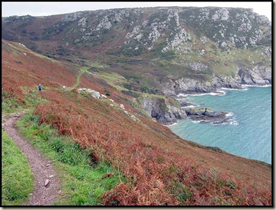
DAY 4
The superb path Sue and I followed to Prawle Point was totally deserted.
 The coastwatch station at the Point was being assiduously manned by volunteers.
We were relieved that we didn't meet the giant ants that built these! 
Here's the rough way ahead to Sleaden Rocks, on the way to Start Point. 
This adder was only about 6 inches long. 
And finally Start Point's lighthouse comes into view. 
The end of our 50 mile jaunt over 4 days - Torcross - is now in sight.
Strangely this sign indicates 168 miles to Poole. So we've come 6½ miles since leaving Plymouth!?

On a stormy night in January 1917 the fishing village of Hallsands collapsed into the sea. Today only these ruins remain. Natural disaster or political conspiracy? Find out more here.
One of the commonest and most colourful of the many flowers seen on this trip was Common Toadflax. 
Our journey, for the time being, ended in Torcross, just beyond this strangely named hostelry, where WG Grace appears to be slogging into the sea. 
Considering the time of year, the wildlife was abundant, with Martins and Swifts gathering for migration, little egrets in the Erme estuary, Red Admiral butterflies, stonechats and wheatears beside the paths, and oyster catchers and many gulls, cormorants and shags on the beaches and coastal rocks.
We noted about 30 bird species and 40 common flowers during our wanderings.


