The main purpose of this blog is to keep in touch with friends and family, and maybe entertain others with common interests, particularly in relation to the outdoors. We hope you enjoy it, and your comments are valued....
Sue and Martin in Mallorca 2019
On the Archduke's Path in Mallorca
Monday, 1 October 2012
Grayrigg Forest - Marilyn Number 998
More female company to come, Gibson.
Sent using BlackBerry® from Orange
Sunday, 30 September 2012
The Relative Hills of Britain
I was (relatively) unaware of ‘The Relative Hills of Britain’ until 8 July 2000, when I attended a friend’s celebration of the ascent of his 800th such Hill. During the course of this event a stranger called Alan Dawson thrust a Cicerone Guide into my hands in return for a modest sum. His book lists, in various ways, all the ‘Relative Hills’ of Britain. They are assiduously numbered, from 1 – Ben Nevis, to 1542 – Muldoanich (an obscure island off Barra).
The book, published in 1992, lists all British hills with a height of 500 feet relative to the height of the surrounding area. Alan christened them Marilyns.
A rather eccentric namesake of mine has slowly been ticking off his ascents of these summits, mainly in Scotland as he lives in Aberdeen. His tally currently exceeds 1000. I go up hills quite a lot, but I’ve only climbed 400 or so Marilyns, so this guy could be considered a bit of a fanatic. He contacted me recently to tell me he’d booked a few Travelodge rooms, with a view to climbing a few English and Welsh Marilyns. Would I like to come along?
We meet later at Kendal Travelodge. What exactly happens after that is anybody’s guess, but it is probable that we’ll climb a few Marilyns.
It should be fun – this blog may feature one or two summit shots. Feel free to skim over them if you get bored!
The picture, BTW, is from one of our bases during the course of the week, from where there is a vast array of nearby ‘Relative Hills’.
Friday, 28 September 2012
Jerzees Colours Mens Hydraplus Jacket – First Impressions
I was recently contacted by an up and coming (according to their website) local business, Polo-shirts.co.uk, part of the Quayside Group which is based in nearby Trafford Park.
“Would you be interested in reviewing some of our items of kit?”
After looking at their website, which states ‘The Quayside Group was established in 1995 and has since grown to become a leading online supplier of wholesale and personalised clothing’, I was pleased to receive this jacket for review.
Here are my initial observations:
The manufacturer’s product details and specification is provided at the foot of this posting. I do not take issue with them.
First impressions:
This garment is not one you will find in outdoor shops, and it isn’t suitable for backpacking as its weight of 740 gm is not exactly light (my ‘medium weight’ RAB jacket weighs 465 gm). The jacket is manufactured by Russell Intelligent Clothing and is basically a breathable PU coated nylon outer with a polyester lining. It doesn’t state the country of manufacture. The current price is £50.00 plus VAT and delivery, less if you order more than 10 jackets. That’s a fraction of the cost of the RAB jacket I used for the weight comparison.
On receipt I immediately donned the jacket to complete an errand on a wet day. It felt like a solid, effective shell, and on a later evening walk at a brisk pace its breathability seemed fine, with no condensation appearing, though I feel it isn’t likely to be as breathable as higher spec Goretex or eVent jackets.
The beading on the new fabric was fine, as you would expect.
Fit:
- the medium size fits my 38” chest with room to spare
- the jacket is comfortable without being snug
- the length is good
- the handwarming pockets are …. handwarming (note – I hadn’t fastened the velcro cuffs at this point)
- the hood folds away neatly, but the peak isn’t stiffened and hasn’t got a volume reduction cord, so it slightly obscures my vision when used in anger, but for the price of this jacket the hood may be regarded as a bonus
- the soft touch collar feels … soft – here’s another picture
- the arms are a good length, with effective velcro adjusters for the cuffs
- the drawcords for the hood and the hem are effective
- the YKK zips on the front and on the pockets are of good quality and have cord pulls for use with gloves. The small zip for the ‘discreet concealed decoration access at hem’ (presumably to give access for embroidering, etc) doesn’t work properly on my jacket, but I suspect most users probably wouldn’t even notice this zip
- the storm flap, secured by velcro, should be effective in most weathers, but there could be ingress in severe weather as the zips aren’t waterproof
- the main zip has a top ‘garage’ and a well designed internal rain flap
- the handwarming pockets are reasonably spacious and the external chest pocket will take a large ‘phone or GPS, but not a map unless folded. There are no internal pockets. So pocket space is limited compared with specific (and more expensive) hiking jackets
- at 740 gm, this is not a lightweight garment, but it’s certainly fit for use as a waterproof jacket for casual use and day walks
- a smart (by my standards) jacket ideal for casual use and for day walks, especially during the cooler months
- for energetic mountain days a more technical jacket may be preferable, but as a budget item this jacket may cope with most conditions
Alternatives:
- numerous manufacturers make similar products, but I’m not aware of any that are as robust as this one appears to be, for such a cheap price
- if you are looking for a cheap but solid waterproof jacket, I doubt you’ll find better value than this
- the jacket is ideal for going out in the rain all year round, and should be good for day walks from autumn to spring (it’ll be too hot for many summer days)
- the jacket is already my first port of call as my outdoor jacket - I’ll be using it for day walks, trips to town, and general casual use – you could do a lot worse than replace your tatty old day to day jacket with this excellent, at first sight, product.
Finally, given the discounts available for bulk orders, and the printing and embroidery services offered by Quayside Group, this jacket or one of the company’s other products may be ideal for those requiring garments for a team, company, or other group that may want (or be required) to wear the same clothing.
Incidentally, I notice that Alan Rayner has recently reviewed Polo-shirts.co.uk’s softshell product here. He likes it, and it appears at first sight to be at least as waterproof as the Hydraplus Jacket, though it lacks a hood and has a smaller chest pocket.
That’s it for now. I’ll add to this review when I have been using the jacket for a longer term.
Manufacturer’s Specification:
Jerzees Colours Men's Hydraplus Jacket
Water resistance to 2000mm (PU coating) breathability of 2000 g/m² per 24 hours, water repellent finish and critically taped seams for full weather protection Active fit: articulated elbows and raglan sleeves Stowaway 3 piece hood and soft touch inner collar Reverse YKK front zip with cord pull, double storm flap with additional Velcro closure Zipped hand warmer pockets with internal pocket for phone/MP3 Fully lined, with discreet concealed decoration access at hem Fully launderable: 30ºC wash (gentle cycle) and low temperature tumble dry (do not use fabric softeners)Thursday, 27 September 2012
Wednesday 26 September 2012 – Styal at Night
I didn’t really expect anyone else to come on this evening walk, so I wasn’t surprised when nobody turned up to join me for a beer in the quiet pub.
Sue is working feverishly at present, so reserved her evening out for a meal with Tim at Chilli Banana tomorrow (ie today). The lane through Styal was deserted and having set off on my walk I saw nobody on the normally busy paths. It was quite eerie at times in the dark woodland with the bulging River Bollin swirling at my feet and the smell of Himalayan Balsam wafting across my nostrils.
My planned 7 km route was abandoned as I knew it would pass through a very muddy farmyard, so instead a circuit via Twinnies Bridge seemed a short (4 km) but sound route choice. And so it was; despite all the recent rain the paths weren’t too muddy, and given the nearly full moon a torch was only needed in the more heavily wooded sections.
A short but very pleasurable excursion on familiar paths.
Here’s the route according to my Garmin gadget:
Wednesday, 26 September 2012
Sunday 23 September 2012 – East Lancashire LDWA’s 40th Anniversary Walk – The Two Crosses
I originally joined the Long Distance Walkers Association (LDWA) in the 1980s when there were around 2000 members. I rejoined last year, when membership had risen to over 7000. Regular readers will know that I’ve subsequently enjoyed outings with the South Manchester and East Lancashire LDWA groups – principally with the more active latter group, in particular its ‘Plodder’ faction.
This weekend the Association celebrated its fortieth anniversary with walks all over the country, so I was pleased to join the East Lancs Group for a stroll around the Two Crosses circuit. The group organises an annual Challenge Walk over this route, involving lots of people and numerous checkpoints. I took part in the shorter 18 mile version earlier this year (see here).
A rather disappointing turnout of nine walkers and a dog called Buzz set off from Tottington Library shortly after 8.30am. Dave was soon leading the way in archetypal LDWA fashion, head down at a fast pace in his ancient glued up trainers. The rest of us followed in hot pursuit past a mosaic cow on what may be the last day of the year on which Ken and Chris would be wearing shorts.
Bogs were soon encountered and were a feature of the day, with Dave zooming through them and the rest of us following in his wake, soon learning to choose our own drier routes rather than join him in the Wet Foot Society.
Shortly before we arrived at Affetside, Barbara leapt out in front of us, offering a rather poor excuse for her lateness, but at least boosting the turnout into double figures. The LDWA’s age profile has increased steadily over its forty years’ existence, so perhaps the membership felt 25 miles was a bit far, or perhaps they had done the Two Crosses walk too many times already! Having said that, today’s ‘elder statesman’ was the one who was consistently making the pace…
Can you spot the cross at Affetside, the first of the 'Two Crosses', on the right of the picture below? Here's our select group - Jake, Chris, Sue, Buzz, Gillian, Dave, Cathy, Ken, Peter, and Barbara.
Soon afterwards we were zooming through Jumbles Country Park, beside Jumbles Reservoir on an overcast late summer's day, with the dark green foliage waiting patiently for the first autumn frosts and winds. Luckily the impending monsoon – the most intense September storm in the UK for over thirty years – didn’t arrive until just after we finished the walk. As I write, 72 hours later, the rain has just stopped in Manchester!
After a while we encountered the bogs and marshes of Longworth Moor. Dave strode through them, pausing occasionally to wait for the rest of us as we picked our way through the dry bits.
An empty house, in the middle of nowhere near Old Man's Hill, had apparently recently been emptied of all contents of value before being abandoned by its owners and no doubt left to optimistic lenders to fight over its future.
Lunch was taken on a convenient couple of benches on the Witton Weavers Way path between Darwen Moor and Turton Moor.
Between the benches, a rather poorly hidden geocache in a plastic box held some modern artifacts, and a stone plaque mysteriously engraved "JPS LEFT MA??? 1894 ____ 1923" could perhaps be a relic from the area's recent industrial past, but I couldn’t find any reference to it in this wordy treatise.
Barbara made a short speech whilst we celebrated the 40th Anniversary with tea, brownies and jelly babies.
Cathy then tried to end her days in a ditch, but Jake and Ken managed to drag her out (see slideshow for picture). Ken had already taken a dramatic tumble when he fell off the path, and several others had also succumbed to the force of gravity in a variety of mishaps. I’ve already noted the aging profile of LDWA members; that was clearly in evidence today, albeit we only had one walking stick between us.
In true LDWA (Irregulars excepted) style, we strode past the Strawbury Duck and its ghostly residents (nobody else looked back).
We continued to trail in Dave's wake on the ascent to Edgworth Moor, with Winter Hill clearly in view beyond one of the many reservoirs around here.
Bull Hill, a HuMP, could have been the high point of this walk, but the LDWA isn't a 'bagging' group, so we skirted around the hill, which was possibly just as well as a convention of trail bikes was being held on the summit.
Eventually we reached the second cross, The Pilgrims' Cross on Holcombe Moor (see the top of this posting). Even Dave stopped to admire it, but I don’t think anyone else spotted the ghostly apparition on its top.
Peel Tower soon came fully into view, before our final descent of the day.
We headed quickly towards a rival group, but not even Dave could catch them, though he did briefly overhaul the lady in jeans who was just ahead of us at this point. It must have been scary for her!
"Time for another break" announced Jake, just as the jeans lady had been caught. That meant more brownies and jelly babies in the shelter of the tower. There was a moderately keen wind up on Holcombe Moor today.
Dave was soon dashing off again. He had very soggy feet by now.
The golden turrets below Peel Tower, in Ramsbottom, house a Muslim education centre from where delegates are apparently often seen around the tower, but not today.
It’s not far back to Tottington from here, and after a peculiar diversion through an overgrown field we rejoined the ‘proper’ route near where the last checkpoint is situated on the Challenge walk. Thankfully there was no maniacal barber masquerading as a Master Plumber to deflect our attempt to finish the walk before the rain, which we could see for the last hour or so, reached us. So the final section was achieved at a good amble, past a pig called Pepper, bringing to an end at 5.30pm this excellent day out in fine company.
I just wish I’d taken a photo of of Dave washing his feet in a bowl of hot water (from a flask brought specifically for that purpose) after finishing the walk.
There’s a 37 image slideshow here, for anyone interested.
Here's an approximation of the 25 mile (40 km) route with about 1000 metres ascent - taking 9 hours including an hour's breaks.
Monday, 24 September 2012
Friday 21 September 2012 – Ingleborough with Mick and Gayle
An email received from Mick and Gayle on Wednesday evening triggered this most enjoyable day trip to Ingleborough.
My day started with a visit to Bernie Bond, to deliver the photos taken when we met him and the lovely Janet on 21 July. Janet was at work, but Bernie kindly handed me a copy of ‘British Mining No 76 – Ingleton Coalfield’, a glossy monograph of the Northern Mine Research Society that traces the history of the coalfield from 1600 to its final abandonment in 1940. Bernie’s interest in the coalfield stems from his love of caving and from the discovery that on moving to Ingleton in 1983 he was living in a house formerly occupied by a colliery manager. Bernie made a huge contribution to the research that has resulted in the monograph, which I shall enjoy reading. Thanks Bernie.
Apart from a short stroll from Thornton Barn, where M&G had parked their van, to Ingleton, this was a repeat of the walk Sue and I enjoyed on 3 January 2009 – an anticlockwise circuit ascending Ingleborough via Crina Bottom and returning via Chapel-le-Dale, Scales Moor and Beezley Falls, for which we again managed to avoid paying, having arrived after the kiosk had shut. [The ‘Waterfall Walk’ is over private land and a charge of £5 is now made for the privilege of enjoying this excellent short walk.]
Today we saw just two people on Ingleborough before the final haul to the summit, from where a large group of very old people was descending, and various others were milling around on the top, some looking muddy enough to be on a ‘Three Peaks’ walk. Rather inconveniently, the final shower before a period of a few days’ good weather arrived as we approached the summit. Never mind, it wasn’t too inclement to take this self-timed photo.
No wonder your hands got cold, Gayle!
The furthest peak visible from the summit of Ingleborough is Manod Mawr in Snowdonia, 103 miles (166 km) away. We couldn’t spot that today, but many other landmarks were visible through the stiff breeze.
Once away from the summit we just saw a few folk approaching the summit, a workman at the chapel, a photographer on Scales Moor, and a family engaged in trying to fall into the river at Beezley Falls, so we had the paths more or less to ourselves. Which was just as well at one juncture when my trowel came in handy.
Up on Scales Moor, Mick was wondering how long the limestone pavement exposed after the last ice age 12,000 years ago would take to be completely ‘grassed over’.
Not in our lifetime, I suspect.
Especially not this glacial erratic, seen here with Ingleborough behind.
Those interested in such erratics and their formation may be interested in this Wikipedia link, and those interested in this region of North Yorkshire may enjoy reading a short document from the National Park Authority on the Yorkshire Moors and Fells.
We passed an isolated tree and, given the rather poor lighting, a hopeful photographer.
There has been a fair amount of rain here in recent days, so unsurprisingly the River Doe was in spate.
There are more ‘waterfall’ images in this slideshow, should anyone be interested.
Here’s our route – about 22.5 km, with 800 to 900 metres ascent (depending on whether you believe Garmin or Anquet) taking about 7 hours.
Here’s the Garmin version of data:
Friday, 14 September 2012
Thursday 13 September 2012 - GR54 Day 13 - Refuge de la Muzelle (2130m) to Bourg d'Oisans (720m)
Another great mountain day to bring the GR54 tour to a conclusion.
At 3am it was snowing outside our dormitory. By 7am we were shuffling our way from the dorm to the dining room for an ample breakfast. Some of those who had been keen to shoot off early on previous days were late risers today, notably the Belgian couple and three French, one of whom was probably still upset and depressed after losing his GPS yesterday. We do hope it turns up.
We established from the guardian that the route over Col du Vallon should be safe, and set off at 8.20. It was an easy 400 metre ascent to the col despite the fresh snow. JF and Steve went ahead, the three French followed, and the Belgian couple plus a fourth French descended (we think) via the easy path to Bourg d'Arud. The two jolly German campers followed us but they weren't seen again today.
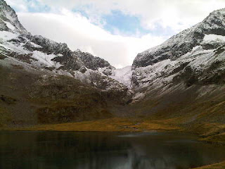
The top picture shows a view back towards the refuge from our ascent to the col. A winter wonderland.
Steve and JP were loitering at the col, but soon buzzed off whilst we found a sheltered spot to wait for Ken, who has a painful knee. It was quite cool in the snow at 2531 metres, though the wind was fairly light.
Great views.
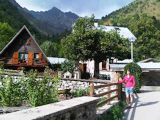
A careful, albeit easy descent led down towards Lac Lauvitel. All too soon we reached the lower margins of the snow, above 2000 metres, from where Sue is pictured (middle) with the hills beyond Bourg in the distance.
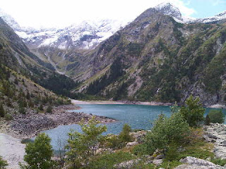
The three French caught and passed us as we continued over steep ground around rocky bluffs to reach Lac Lauvitel (pictured - bottom) at 11.20 am. We spent 45 minutes at this beautiful spot, where we enjoyed an early lunch of bread, cheese and salami - the uneaten portion of yesterday's packed lunch.
Resuming our route soon after 12, we paused to photograph a very bold marmot (visitors feed them here), before climbing a rocky path to gain more views of the lake. A well constructed path then descended steadily, and all of us removed layer after layer of clothing.
We continued into zones of shrubs, then trees, with a river flowing noisily beside the path. Our plan of stopping at La Danchère's buvette failed, as it was closed, but we looked into the small church with its mosaic glass windows, and ate our remaining supplies on a bench.
Back on the path after some adventures with a footballing dog, we passed huge 7 inch diameter mushrooms, then descended on the left bank of a river, coming out at the hamlet of Les Gauchiors.
Then it was a track through woodland in dappled sunshine, avoiding large puddles, for some way. But it was flat, easy walking, with a few flowers for interest, not far from the Romanche river.
The streets coming into Bourg d'Oisans were plain, but adorned with huge, colourful hanging baskets. So it was that at 4pm our 13 day GR54 circuit was closed and we joined Steve outside a street corner café for celebratory drinks.
Later, after the pleasure of rooms with baths in Hotel des Alpes, we enjoyed more beers, together with Steve and JF (who turns up like a bad penny at the very mention of alcohol), before all seven of us adjourned to La Muzelle for an excellent meal and a treat from Ken by way of some real bottles of red wine, a nice change from our usual litre pichets!
Then we had a good sleep before travelling home. As I write (10pm Friday) some are still travelling. Bon voyage, thanks for your excellent company over the past fortnight, and by the time you read this we hope you have arrived home safely.
Postscript
Previous Day
Back to Index
Thursday, 13 September 2012
The View from Refuge de la Muzelle
Top - on arrival at 11.30
Middle - after lunch
Bottom - late afternoon
The refuge has no heating, apart from our group of 12 plus three campers' body heat. So as I write this (6.30pm, and many folk are wandering around in blankets) we are looking forward to something warm coming from the warden's warm kitchen.
Tomorrow's return to Bourg d'Oisans could be something of a culture shock!
Next Day
Previous Posting
Back to Index
Wednesday 12 September 2012 - GR54 Day 12 - Valsenestre (1294m) to Refuge de la Muzelle (2130m)
Basically, a wet day in the Alps.
We woke as expected to leaden skies, and as usual our little group was last to leave the gite, at 7.50, half an hour earlier than usual. This gave us fifteen minutes before a light drizzle drew attention to the need to don our waterproofs.
It wasn't a day for long breaks. The 1350 metre ascent to Col de la Muzelle was a steady plod taking rather less than three hours. By the time we got there the party ahead of us was about to leave, having seen enough of the sleet that was today's meteorological feature at the col. There had been some respite on the way up, with good views back to Col de Côte Belle, pictured - top, just to the right of the bobble that is Côte Belle. In fact our waterproofs came off for a while.
The ascent to Col de la Muzelle is noted in Kev's guidebook as being up a potentially difficult shale cone. Since his book was published, according to Hélène, the path was closed for three weeks in 2010 to enable it to be widened sufficient to be negotiated with safety in all but the very worst weather. Accordingly, it presented no problems at all today.
We found a sheltered spot on the col, where Ken arrived late and left early. The views, it has to be said, were limited, but at least we weren't in cloud, nor was it particularly cold. Steve was appointed as group photographer, and he performed the task admirably - see middle picture (Ken was long gone).
A rare (and very brief) phone signal delayed my departure, as the opportunity to catch up with these postings couldn't be missed!
Refuge de la Muzelle was clearly visible beyond a nearby lake, and was reached in about 40 minutes from the col. By now the drizzle had turned to rain, and the weather deteriorated further after our 11.30 arrival at the refuge. The bottom picture was taken later in the day when the rain had stopped. A blanketed resident is to be seen on the balcony of the chalet style refuge.
We are with the same people as last night. A friendly crew.
Whilst we had picnic lunches from Valsenestre, the allure of hot meals proved irresistible, so we enjoyed omelettes and pasta carbonara, leaving the perishable part of our packed lunches until later, and the rest for tomorrow.
Next Day
Previous Day
Back to Index
Wednesday, 12 September 2012
Tuesday 11 September 2012 - GR54 Day 11 - Le Désert-en-Valjouffrey (1255m) to Valsenestre (1294m)
Whilst plying us with breakfast, Marie Claude told us that the village of Désert-en-Valjouffrey has only fifteen permanent residents plus a barking dog, a far cry from days of old - in the 1850s the population was apparently 200 to 300. The interesting house in which we were staying was built in 1788. Marie Claude's house may have been older - the dining room had a catacomb like ambience, with massively thick walls and huge broadening pillars supporting the floors above.
The forecast was for afternoon rain, so we got away at 8.30, expecting to get wet later. We didn't - the rain, just a brief shower, didn't arrive until after 5pm, so we enjoyed another sunny day on the GR54 trail.
The path up to Col de Côte Belle was unrelentingly steep until we got to some high, well graded zigzags. Having said that, we are 'match fit', so the 1050 metres only took us two hours.
There was a party in full swing at the grassy col. Lots of cameras were swapped and pictures taken.
Then Sue arrived, delayed by botanical diversions, and we had to start all over again.
We cracked open our packed lunches. The boiled eggs were delicious.
Our new found friends soon departed - we would all reconvene at the gite later - and we lingered for an hour at this great vantage point. Of particular interest was the view towards tomorrow's route over Col de la Muzelle. It looks easy enough until the final 200 metre ascent of a steep cone of black shale, grit and slate up to its 2625 metre crossing of the ridge linking Pic du Clapier du Peyron (3169m) and Roche de la Muzelle (3465m).
The top two pictures (I couldn't decide which I preferred, so I've included both) show the view towards the col (the lowest point on the horizon) from the start of our descent to Valsenestre.
Just 100 metres above the col, the summit of Côte Belle lurks enticingly. So much so that Sue, Susan and Roy felt obliged to visit it, for very similar views that Ken and I had from our spot on the col where we were guarding the bags against marauding Belgians.
Apparently the summit area was littered with large edelweiss plants.
The walk down featured an area of slate-like slabs - spiky and shattered, one of which precariously overhung the path. The vegetation increased as we got lower - shrubby stunted trees, then birch woodland, then larch, pine and fir trees.
Views towards the Col de la Muzelle steadily improved. We'll have enough to fill an album!
The rest of our packed lunches were scoffed at a path junction where we decided not to take advantage of the good weather to go over the col to Refuge de la Muzelle, but to risk that walk in tomorrow's forecast bad weather and descend to Valsenestre as planned today.
After passing some Belgian picnickers, we stumbled into the pretty village of Valsenestre at 2pm. The gite d'etape Le Béranger was very much open. 'JF' (Jean Francois - classical guitarist turned civil engineer), the Belgian camper, was enjoying a beer outside.
We soon settled into a relaxing afternoon at the gite (pictured - bottom, behind the tree), with the rest of the GR54 gang. There are twelve of us plus JF and two Germans who are camping nearby. The only other Brit is Steve, from Bristol.
Hélène is catering for us more or less single-handedly. She lives 'down the valley'. In fact all the summer 'residents' of this pretty spot live elsewhere. The whole steep-sided valley is shut in winter due to avalanche danger.
We enjoyed a fine meal at our 12 strong table, which became 13 when JF turned up in search of pickings - he's a 'poor student' - he got them. Cheers JF!
There's no signal here but a comment from Helen appeared at some point during the day. Hello Helen. This will probably therefore be one of a series of postings to be sent on Thursday, when we should get the first phone signal since Sunday lunchtime!
Next Day
Previous Day
Back to Index
Monday 10 September 2012 - GR54 Day 10 - Refuge des Souffles (1975m) to Le Désert-en-Valjouffrey (1255m)
Roy devised his own alarm system whereby the volume of his snores grew louder and louder until, at 7.15 precisely, they had woken everyone in the room including himself.
The couple running the refuge were a little strange; perhaps they were on something that made their behaviour a little erratic. Breakfast arrived in small quantities until more was requested, then it came with a smile. Some puzzlement was exhibited when the guardian arrived with our coffee, only to find we'd filled the only bowls provided with muesli. He simply waited for us to finish the muesli before pouring the coffee.
Sue's 'tea' arrived in the form of a jug of hot water. Eyebrows were raised when she was cheeky enough to ask for a tea bag. "Heathens" observed George, the Chilean Francophile.
By 8.20 we were ready to join the short string of trekkers who were heading for the Col de la Vaurze (2498m). It was another cloudless morning, with clear visibility thanks to last night's storm. The day remained sunny throughout.
For the first hour we enjoyed an undulating belvedere path that headed deep into a combe punctuated by rocky spurs and stream-cut gullies. Sue is pictured (top) crossing one of the spurs. A young Belgian couple soon overtook us, leaving just the campers behind us.
It was a delightful path (pictured - middle) in perfect weather. Soon the slope steepened for the final 400 metres up to the col, but the path hardly got any steeper at all, instead choosing ever lazier zigzags past recumbent sheep and hovering birds of prey to manoeuvre its way up the hillside and eventually reach the fine vantage point of Col de la Vaurze, from where our destination for the day was just visible as a collection of rooftops 1200 metres below us. There were of course many fine mountain views from this spot, including 3564 metre d'Olan to the east.
We were last to leave out of the little group of GR54 trekkers at the col. The descent was at first quick and easy, then care was needed to cross a few steep gullies. A grassy spur at 1900 metres provided a fine venue for a lengthy break, near a shepherd's hut with a tethered goat. Susan had a long chat with said animal but has so far declined to share the wisdom imparted to her.
The entire descent offered a clear view of tomorrow's route to Col de Côte Belle (pictured - bottom) and as we continued down to Le Désert we paused frequently to admire that view and the fine vistas north east to the ring of mountains at the head of the Vallée du Valjouffrey.
Lower down, we passed through ancient walled lanes lined with crocuses and red berries, beside meadows intermingled with piles of rocks (cleared to form the meadows) that made the area look like a golf course from above.
Our accommodation in Le Désert, booked by Sue back in June, was to be at the Bar des Écrins, which we guessed would also serve lunch. We arrived at 1pm to find it conclusively shut. Luckily, further down the road at Auberge l'Eterou, Marie Claude was able to offer us a three bedroomed holiday house in a nearby building, and half board and a packed lunch (the shop we'd hoped for was at Bar des Écrins) for €55 each. She lost an arm (so to speak).
Somehow we'd managed to overtake the rest of the GR54 brigade, and soon they were milling around outside our gated courtyard. We peeped over the fence to say hello and wish them well in their quest for lodgings and provisions.
Meanwhile, Susan, Roy and Ken managed to produce from the hidden depths of their bags enough bread, cheese and salami to provide plenty of lunch for the five of us.
Thanks, Alan R, for your comment (there may be more but we have no phone signal in Le Désert!). I don't think I'll have the Blackberry for much longer, and the negligible cost of postings and messages isn't a problem; and I've yet to enter the mysterious world of 'Apps'!
Later:
Five other trekkers were located at the gite that is apparently connected with the Bar des Écrins. It's some way from the Bar. We had no way of knowing. Anyway, it seems they may have taken our places at that gite. We aren't complaining. Whilst they had beer, we had three separate bedrooms and a well fenced garden in which Sue and I could spend an hour or two in our underwear whilst we washed and dried our trousers for the first time on the trip.
Ken could do his exercises (as if the walk wasn't enough!), and Susan and Roy strolled up to a cascade and back. Gulian seems to have gone home, and Jean Francois, the camper, has disappeared.
Later still:
Marie Claude's attentively served meal was most enjoyable - courgette quiche > two massive sausages and Dauphinoise potatoes > a selection of cheeses > chocolate cake and chartreuse ice cream, with the usual few pichets of red wine.
Excellent.
Next Day
Previous Day
Back to Index
Monday, 10 September 2012
Sunday 9 September 2012 - GR54 Day 9 - Refuge de Vallonpierre (2271m) to Refuge des Souffles (1975m) via Col de Colombes
Our longest day of the trip - on excellent paths throughout.
We were early to bed and early to rise for the basic hut breakfast. By the time we left at 7.15 it had been light for about thirty minutes and the sun was glinting enticingly on a distant summit. More photos were taken of the idyllically situated refuge and its reflection in the lake.
A switchback path got us down a few hundred metres, then a good undulating path over easy ground past a crowded but completely silent pen of sheep led eventually to Refuge du Clot, where the guardian jokingly asked for money when Sue wanted him in a photo of the refuge.
He charged just €1.30 each for our coffees - very reasonable. It looks a nice refuge, and several of those who we met at Chaumette stayed there last night, but its location doesn't compare with that of Vallonpierre.
Beyond Clot, a series of delightful paths led to La Chapelle-en-Valgaudemar. They took us down ancient walled lanes and through woodland where the sun's dappled light played with shadows on the tree-lined paths.
Open fields (pictured - top) and narrow ways etched into steep slopes also featured, and on the final approach to La Chapelle our eyes were drawn across the valley to the spectacular Cascade de Combefroide, beside which we would shortly ascend.
La Chapelle was buzzing with people. It's clearly a popular tourist destination. A pleasant little village with a food shop and a couple of cafés, one of which Sue and I utilised to enjoy a first lunch of what turned out to be deep fried potato croquettes.
Supplies duly replenished, we set out after a chat with Alain, and with another totally unconnected stranger. At Vallonpierre, Myriam had pointed out a route that she said was much better than that taken by GR54. We took it. Over Col de Colombes. It was a long, steepish, 1300 metre ascent, initially past the Combefroide cascade. This wasn't so spectacular close up, as you could only see a small part of it at any one time.
We climbed the first 900 metres at a good pace in less than two hours. There was lots of ling (heather) just about in flower to brighten our journey. Small birds of prey hovered nearby, and the constant chirping of grasshoppers and flitting of butterflies distracted us from the steadily increasing cloud cover.
Lunch (second instalment, usual fare) was taken at around 2000 metres beside a burbling stream, then we headed up the final 400 metres to the col. Susan and Roy (pictured - middle) zoomed on ahead whilst Ken was today's stalwart backmarker. There were fine views of other enticing higher paths leading to the Breche de Roland like Pas de l'Olan.
Skies were uniformly grey by the time we reached the 2410 metre col, where the others are pictured (bottom) shortly before the first drops of rain.
Col des Clochettes soon came into sight as we hastened past a small lake that in sunnier conditions would have seen some of our party baring all. We passed George, a Chilean who lives in Paris and Barcelona, and his lady friend Morgan. It drizzled a little as we descended to the small but perfectly formed Refuge des Souffles, which turns out to be virtually full tonight, with nearly 30 visitors. We again have a dormitory to ourselves!
After Roy had gone bilberry harvesting, and various ablutions had been achieved (washing clothes, showering, etc), we watched a storm outside before adjourning to the crowded dining room where we enjoyed the evening in the company of the aforementioned George and Morgan, and Peter from Malvern, the first Brit we have encountered since starting our walk over a week ago.
A number of the people we met at Chaumette two nights ago are here, together with a large guided party. Jean Francois, camping outside but dining in the refuge, confirmed our thoughts that the GR54 route from La Chapelle is not as good as our Col de Colombes route, due to a 'steep and hot wooded path with lots of flies' the way he came. Others agreed that the Colombes route is to be commended.
Comments:
Thanks everyone, they are appreciated. And sorry about the build up of postings - we went for over three days without a phone signal, a record for me in nearly five years of blogging.
Next Day
Previous Day
Back to Index
Sunday, 9 September 2012
Saturday 8 September 2012 - GR54 Day 8 - Refuge du Pré de la Chaumette (1790m) to Refuge de Vallonpierre (2271m)
Another fine mountain day. Short, but with three high passes.
Dawn was again cloudless, and it took a few hours for the clouds to start building, so most of the day was spent in bright sunshine. After the traditional breakfast (coffee, bread, jam) in this traditional refuge we set off last of the thirteen guests, just before 8.30.
We managed 300 metres of the well graded 800 metre ascent to the Col de la Vallette before emerging from the shade of the valley into the sun cream zone. The others are pictured here (top).
Kev's guidebook refers to some 'scrambly pitches and narrow ledges' which we hardly noticed on this fine day.
After using Gillian Price's guidebooks we had got used to a fairly relaxed attitude to any difficulties presented to Gillian; Kev Reynolds seems to me to be just a little more cautious with his descriptions. This is not a criticism of either author, just a comparison of styles. Anyway, today's walk brings several warnings from Kev, and as on many mountain walks a slip could have been painful. But careful negotiation of the good paths across steep scree in the fine weather presented no difficulties to our international group. It would undoubtedly be harder in wet conditions, and walking poles were certainly helpful today, especially in descent.
Col de la Vallette is only 50-60 metres below a small 'pap' which promised fine views. So we went up it. And there were. I even took a video, first of the trip. A great viewpoint. Sue, Susan and Roy are pictured here (middle).
Back at the col we met Alain, a Frenchman on a day walk. He was about to leave. We persuaded him to go up the pap.
Two more cols were then visited. The first, Col de Gouiran, involved only 120 metres of ascent and was very easy. The second, Col de Vallonpierre, involved steep shaley scree on both sides of its narrow crest. We lunched here and I lingered at the fine vantage point for an hour or so whilst the others ascended a further 130 metres along the shaley crest to Pic de Vallonpierre (2738m), from where they got a good view of today's refuge.
A French backpacking couple shared my perch on the col. They were still there long after we headed off. Perhaps they would camp in the idyllic area around the source of the Torrent de Vallon Plat.
It's good to see these genuine backpackers, as this whole area is eminently suitable for that activity, with huge numbers of idyllic sites, though fixed camping is not permitted in the National Parks, so you have to move on every day. Fair enough.
It was an easy walk down to the perfectly located Refuge de Vallonpierre, where climbers Myriam and Daniel have been guardians for nine years. Contrary to Kev's information this is a CAF refuge, built in 2000 and still looking very new. (Pictured - bottom.)
On reaching there at 2.30, two litres of tea were in order. We enjoyed that, and some cake etc, whilst gazing up to the summit of Le Sirac, flitting in and out of cloud some 1200 metres above us. The refuge nestles beside a small lake. There's a resident telescope on the patio, with which to view eagles as well as climbers on Le Sirac. Today there were four climbers - two couples who had set off at 7am and who returned at around 3.30, in plenty of time to go down to the valley.
There are 13 guests in the 39 bed refuge tonight. We are in a dormitory for nine together with a family of four, who like eight others didn't turn up, so it won't be as cosy as expected. My feet will be next to Ken's head, so hopefully he can be silenced without too much difficulty.
We enjoyed another excellent meal tonight, in the engaging company of two sisters, Manon and Anne, from Grenoble, the former an aspirant chemical engineer, whilst Anne works in land management. Hello to both of you if you read this.
Next Day
Previous Day
Back to Index
Friday 7 September 2012 - GR54 Day 7 - Refuge des Bans (2076m) to Refuge du Pré de la Chaumette (1790m)
A great mountain day in superb weather.
After breakfast involving lots of coffee and home made or locally produced jams and honey, we waved goodbye to Stéphane, forgetting unfortunately to record on film the refuge's solar oven (I'll have to delve into some Himalayan memories to locate a picture of something similar) or its outhouse, the view from which was the same as that on the last but one posting.
It was a cloudless day as we arose shortly before the 7.15 am dawn. The sun warmed us as we descended for an hour and a quarter back to Entre-les-Aygues, pausing frequently to admire the views back to the refuge, sited dramatically on a rocky outcrop.
Our path now rejoined GR54 for the rest of the day and beyond. A long bridge saw us safely across the Torrent des Bans, where we paused for a break in the sunshine before heading up the pleasantly shaded Vallon de la Selle - a long valley in which we commenced a 1200 metre ascent to the 2761 metre Col de l'Aup Martin.
We soon re-entered the Écrins National Park and were rejoined by the warm sun before we reached the Lacroix pastoral cabin, where two young shepherds seemed to have their hands full, with two large horses, half a dozen donkeys, a small but adventurous cat (it followed us up the hill) and substantial herds of cows and sheep.
Our first attempt at elevenses was abandoned due to excessive horse attention and slobber, but after the second and successful attempt we ambled on up the good path, with fine views (pictured - top) up the Selle's side valleys.
Lunch was taken on a grassy spur below the final 300 metre ascent over 'black scree' to the col.
Given the dry weather the ascent over the scree presented no difficulties at all, and we reached Col de l'Aup Martin soon after 2pm. The middle picture shows me at the col.
There were several others on the path today, and we joined one of them here - Gulian - walking GR54 like us, for the lovely contouring route to another col, Pas de la Cavale, before he went ahead on the final descent to tonight's refuge.
We paused at this second pass to admire a golden eagle, soaring so fast that Sue was unable to focus the binoculars on it, perhaps distracted by the din of squealing marmots, though I was able to catch it with the camera. Not a prize winning photo though.
Soon after starting our 1000 metre descent, the refuge came into view, but it would be a good two hours before we were down there enjoying beers in the warm late afternoon sunshine.
The zigzag path down had so many hairpins that it seemed like a walkers' answer to Italy's Stelvio Pass.
There were thirteen of us staying at the refuge. The rest were French. We were segregated. It was good to have a hot shower and a dormitory of our own, notwithstanding Ken's snoring, and the French were all very friendly, especially Gulian, who seems to be managing fine with trail shoes, and Jean Francois, who is camping nearby and seemed surprised that he was struggling to keep ahead of us today despite his heavier load. We must look very old!
After another good meal, darkness and bedtime arrived in quick succession. The end of another fine Alpine day.
Next Day
Previous Day
Back to Index
Thursday 6 September 2012 - GR54 Day 6 - Vallouise (1166m) to Refuge des Bans (2076m)
The predicted sunshine arrived today. Once again we spent little time on GR54 as we'd planned a side trip to the small Refuge des Bans, as insurance against bad weather.
So it was a leisurely departure from the pretty village of Vallouise, where the Thursday market provided all manner of enticing goodies for some of our party's lunches for the next few days. Food shops will be a rarity as we have now entered the more remote southern areas of the Écrins region.
Last night's gite accommodation was in the classic French style - cheap, homely, with good food (including a cassoulet with chicken and broccoli) and wine on the house. Well done Denis and Maryline.
A good track along the left side (right bank) of the Torrent l'Onde took us as far as a small campsite at Pont des Places, then we forsook GR54 in favour of Maryline's suggested path which continued on the right bank of the river. This made for an entertaining half hour or so, as the path narrowed and undulated before finally crossing a bridge to reach the tarmaced road near a small chapel. A few minutes along this quiet road (pictured - top) saw us reach the road head at Entre-les-Aygues, to which we will return tomorrow.
Before leaving Maryline's unsigned path we stopped abruptly to admire an adder that was sunbathing on the path. We don't often see snakes in the Alps. Today there were also lots of lizards about, whilst dippers and grey wagtails flew up and down the torrent, and nutcrackers, jays, willow tits and great tits were noisy in the woodland. Wheatears and redstarts followed our progress above the tree line.
My thermometer read 29C. It was hot going along the excellent path to the Refuge (pictured - middle, with the refuge hardly discernible in the distance), which we reached a couple of hours later, having taken a half hour break in the shade for lunch.
Sue and I had enjoyed a very modest lunch on the trail, so omelette and chips went down well with some cola, whilst the others duly supplemented their earlier cheese and baguette lunches with cold beers (pictured - bottom).
Refuge des Bans is 'guarded' by Alice and Stéphane, who makes excellent chips.
We met quite a few day walkers returning to their cars after lunch or snacks at the Refuge. But tonight just the five of us are staying. So we can choose our positions in the 22 bed dormitory. The washroom comprises an outside tap, and the lavatory is in an outhouse that may be interesting to locate in the dark.
This afternoon Ken went to play in some snow whilst the rest of us headed up a vertiginous path behind the Refuge. I soon gave up and stopped to compose this entry. The others went some way further but didn't gain a significantly different view to that from the refuge - see separate posting.
Next Day
Previous Posting
Back to Index
The View from our room at Refuge des Bans
(This posting was intended to be made on Thursday 6 September but has been delayed due to the lack of a signal in a remote mountain area.)